-
توجه: در صورتی که از کاربران قدیمی ایران انجمن هستید و امکان ورود به سایت را ندارید، میتوانید با آیدی altin_admin@ در تلگرام تماس حاصل نمایید.
You are using an out of date browser. It may not display this or other websites correctly.
You should upgrade or use an alternative browser.
You should upgrade or use an alternative browser.
تجزیه و تحلیل وضعیت جوی در سال زراعی 93-94 /فصل دوم( دي- بهمن-اسفند)
- شروع کننده موضوع heaven1
- تاریخ شروع
- وضعیت
- موضوع بسته شده است.

اون لگو رو چرا روی تهران زدی . دید تهران رو گرفتی :خنده1:
رو تهران که نيست
Amir Mohsen
متخصص بخش هواشناسی
قبلا بارها و بارها گفتم ولی باز هم میگم ، سامانه پیشرو از نوع upper level low pressure و این نوع سامانه ها چند stage دارند و اصولا با هسته هوای بسیار سردی همراهی میشن.
پیش بینی نحوه عملکرد این نوع از سیستم ها و نقاطی که تحت تاثیر قرار میده بسیار سخت و دشوار هست و همیشه این نوع سامانه ها بعنوان یک کابوس برای هواشناسان یاد شده.
دقت کرده باشید مدلها دائما در سر در گمی بسر میبرند!
این سامانه ها با پدیده هایی همچون: باران - تگرگ -برف و جبهه های گاستی با وزش باد بسیار شدید و گرد و خاک هم همراه هستند.
این نوع از سامانه ها باید در بازه زمانی کوتاه مدت و در واقع ساعاتی در زمان موعد باید تحلیل و بررسی بشه!
خطابم هم با اونهایی هست که خیلی زود نا امید میشن و آه و ناله سر میکنند و هم اونهایی که باید یک آپدیت خوب مست و شاد و مسرور !!!
خواهشا متعادل رفتار کنید و سعی کنید بیشتر تحلیل در مورد نحوه عملکرد این نوع از سامانه ها بدین تا اینکه بصورت لفظی با هم بحث و جدل کنید.
در مورد این سامانه سرچ کنید ، نقشه و یا تحلیل به اشتراک بذارید بعد اون موقع دید خوبی نسبت به تغییرات نقشه ها خواهیم داشت.
بله مارچ منظورم بود
هادی جان سلام
فوریه و در ادامه ماه مارچ فکر کنم منظورتون بود
فعلن آپريل بسيار بد پيش بيني شده
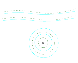
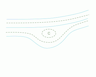
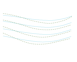
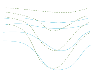
Upper Level Lows are closed cyclonically circulating eddies in the middle and upper troposphere. They are sometimes also called "cold drops", because the air within an Upper Level Low is colder than in its surroundings. The development of a typical Upper Level Low goes through four stages, during which a bottom of an upper trough is detached from the main stream, until it finally fills up or merges with another trough:
[h=2]2. Tear-off stage
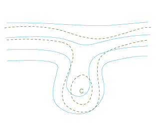
[h=2]3. Cut-off stage
[h=2]4. Final stage Within an Upper Level Low there is convection, unless the surface is very cold. The air near the surface is warm and the circulation is slowed down by the friction. The convection brings warm air and friction upwards. Consequently, the Upper Level Low weakens slowly.
For an example see Key Parameters. If the Upper Level Low is far from the main stream, it can dissolve solely by convection. This kind of development occurs mostly in southern areas; in Europe they can be found over the Mediterranean.
Upper Level Lows can be divided into two classes according to their size and lifetime:
- Upper level trough
- Tear-off
- Cut-off
- Final stage
- There is cold advection within the trough and warm advection on the ridge of the geopotential wave.
- The vertical axis of the trough has a backward-oriented inclination with height.
- The amplitudes of the waves increase; the wavelenght can decrease.
| Cyan: 500 hPa geopotential height, green: 500 hPa temperature | � |
|
|
[h=2]2. Tear-off stage
- The amplitudes of the waves increases further.
- The isohypses form an inverse omega-shape and the cold air flows into the middle of this omega.
- Often at the same time the ridge behind the main upper trough continues to move eastward quicklier than the trough, appearing to "fall forward".
- In the end of this stage the cold bottom of the trough is detached from the main stream.
[h=2]3. Cut-off stage
- The bottom of the upper trough is completely detached from the main stream forming a closed circulation.
- If there is a strong forward-falling ridge behind, it may also separate from the main stream and form an upper level high (a counterpart for the upper level low). This happens in most of the ULL cases.
- The cold core of the Upper level Low warms up slowly because of the diabatic warming of the sinking clod air.
- If a cold Upper Level Low is situated over a warm surface, convection arises within the core. This occurs especially over the Atlantic Ocean (Canarian Isles) and over the Mediterranean in summertime.
- Another location for convection is ahead of the low within the area of a thickness ridge.
[h=2]4. Final stage Within an Upper Level Low there is convection, unless the surface is very cold. The air near the surface is warm and the circulation is slowed down by the friction. The convection brings warm air and friction upwards. Consequently, the Upper Level Low weakens slowly.
- In most cases the Upper Level Low merges with the main stream before it has completely dissolved by the convection. Usually a large trough in the main stream approaches from the rear and catches the upper level low.
- The Upper Level Low can also merge with another Upper Level Low.
For an example see Key Parameters. If the Upper Level Low is far from the main stream, it can dissolve solely by convection. This kind of development occurs mostly in southern areas; in Europe they can be found over the Mediterranean.
Upper Level Lows can be divided into two classes according to their size and lifetime:
- small lows with a lifetime of 2-4 days
- big lows with a lifetime of 5-14 days
بررسی اثر انسو بر توزیع بارش فصلی ایران
http://geophysics.ut.ac.ir/JournalData/1388.4/ahmadi.pdf
http://geophysics.ut.ac.ir/JournalData/1388.4/ahmadi.pdf


با توجه به شاخصها، اين نوع اپديت كه وزن بارشها رو برد به سمت غرب واسه امروز كاملا طبيعي بود
و اما بترسيد از اپديتهاي پس فردا كه دگرگون ميشوند و وزن بارش رو مياره دوباره سمت خودمون
پس اي دوستان من در شمال شرق مبادا نگران باشيد و هراسي به دل راه دهيد زيرا پيروزي از آن ماست:گل:
و اما بترسيد از اپديتهاي پس فردا كه دگرگون ميشوند و وزن بارش رو مياره دوباره سمت خودمون
پس اي دوستان من در شمال شرق مبادا نگران باشيد و هراسي به دل راه دهيد زيرا پيروزي از آن ماست:گل:
با توجه به شاخصها، اين نوع اپديت كه وزن بارشها رو برد به سمت غرب واسه امروز كاملا طبيعي بود
و اما بترسيد از اپديتهاي پس فردا كه دگرگون ميشوند و وزن بارش رو مياره دوباره سمت خودمون
پس اي دوستان من در شمال شرق مبادا نگران باشيد و هراسي به دل راه دهيد زيرا پيروي از آن ماست:گل:
بارش هاي غرب و ترکيه شامل 2 موج هست اين موج و موج بعدي که از 3 شنبه هفته بعد وارد کشور ميشه
Scientists try to unravel warming’s impact on jet stream
- See more at:
http://m.thejakartapost.com/news/2015/02...XgeYS.dpuf- See more at:
A winter of strange weather and turbulent transatlantic flights has scientists asking: Has a predicted climate imbalance of the jet stream begun?
The Arctic is warming faster than other parts of the world, and scientists believe that is having a dramatic impact on the jet stream, which may be responsible for the unusual weather and stronger upper atmospheric winds of late.
On Jan. 8, thousands of Britons were left without electricity in the aftermath of the most violent storms to hit the isles in more than a century. British Airways flight 114 carried by strong winds journeyed from New York to London in a record five hours and 16 minutes.
Several jetliners flying from Europe to North America in recent weeks faced powerful headwinds, which forced them to make unscheduled mid-flight stops to refuel.
The jet stream — a narrow, variable band of westerly air currents miles above the Earth — is strongest in winter, when boundaries between hot tropical and cold polar air masses are most pronounced.
Currents can be even more turbulent at high altitudes flown in by jetliners some 10 kilometers above the Earth, where winds can reach 300 kilometers per hour.
Since 2012, researcher Jennifer Francis of Rutgers University in New Jersey has been trying to develop new scientific tools to study these “very messy” changes in the jet stream.
She revealed her preliminary findings to the Royal Society of Britain last fall.
“Last winter and this winter the jet stream has been unusually strong,” she said, adding that scientists expect more of the same in coming years.
“The Arctic melting,” she explained, “is happening very rapidly and it must be having an impact on the jet stream.”
But not every expert feels the same way.
Climate expert James Screen of the University of Exeter, who recently co-authored an as yet unpublished paper on the impact of Arctic warming on the jet stream, is skeptical of any direct link between the dramatic retreat of Arctic sea ice and more turbulent air travel.
“I have not seen any evidence to suggest a trend in the speed of the jet stream over the past few decades,” he said in an email.
He added, however: “That is not to say that climate change may not impact the jet stream in the future.”
The jet stream changes from year to year due to natural climate variability, Screen explained, so it is difficult to detect “robust trends.”
Reading University climatologist Paul Williams told AFP that “equator-to-pole temperature difference is decreasing in the bottom few kilometers of the atmosphere because of rapid Arctic warming.”
Research shows “evidence that the lower part of the jet stream is weakening as a consequence,” Williams said. But planes cruise at higher altitudes, where wind shears are believed to be strengthening.
More study is needed, he said, but the impacts on aviation in the coming decades “could be more clear-air turbulence, resulting in a bumpier ride for passengers.”
In motion: In summer 2010, a high-pressure area split westerly winds over Russia and Pakistan, causing extreme drought and floods.
- See more at:
http://m.thejakartapost.com/news/2015/02...XgeYS.dpufThe Arctic is warming faster than other parts of the world, and scientists believe that is having a dramatic impact on the jet stream, which may be responsible for the unusual weather and stronger upper atmospheric winds of late.
On Jan. 8, thousands of Britons were left without electricity in the aftermath of the most violent storms to hit the isles in more than a century. British Airways flight 114 carried by strong winds journeyed from New York to London in a record five hours and 16 minutes.
Several jetliners flying from Europe to North America in recent weeks faced powerful headwinds, which forced them to make unscheduled mid-flight stops to refuel.
The jet stream — a narrow, variable band of westerly air currents miles above the Earth — is strongest in winter, when boundaries between hot tropical and cold polar air masses are most pronounced.
Currents can be even more turbulent at high altitudes flown in by jetliners some 10 kilometers above the Earth, where winds can reach 300 kilometers per hour.
Since 2012, researcher Jennifer Francis of Rutgers University in New Jersey has been trying to develop new scientific tools to study these “very messy” changes in the jet stream.
She revealed her preliminary findings to the Royal Society of Britain last fall.
“Last winter and this winter the jet stream has been unusually strong,” she said, adding that scientists expect more of the same in coming years.
“The Arctic melting,” she explained, “is happening very rapidly and it must be having an impact on the jet stream.”
But not every expert feels the same way.
Climate expert James Screen of the University of Exeter, who recently co-authored an as yet unpublished paper on the impact of Arctic warming on the jet stream, is skeptical of any direct link between the dramatic retreat of Arctic sea ice and more turbulent air travel.
“I have not seen any evidence to suggest a trend in the speed of the jet stream over the past few decades,” he said in an email.
He added, however: “That is not to say that climate change may not impact the jet stream in the future.”
The jet stream changes from year to year due to natural climate variability, Screen explained, so it is difficult to detect “robust trends.”
Reading University climatologist Paul Williams told AFP that “equator-to-pole temperature difference is decreasing in the bottom few kilometers of the atmosphere because of rapid Arctic warming.”
Research shows “evidence that the lower part of the jet stream is weakening as a consequence,” Williams said. But planes cruise at higher altitudes, where wind shears are believed to be strengthening.
More study is needed, he said, but the impacts on aviation in the coming decades “could be more clear-air turbulence, resulting in a bumpier ride for passengers.”
In motion: In summer 2010, a high-pressure area split westerly winds over Russia and Pakistan, causing extreme drought and floods.
- See more at:
Winter 2014/2015: More Like Spring
By Blaise Keller, KDLT Weather Weekend Meteorologist, [email protected]
Published On: Feb 15 2015 09:22:53 PM CST
Share on facebook Share on twitter Share on google_plusone_share Share on pinterest_share More Sharing Services
Meteorological winter starts at the beginning of December and lasts through the end of February and, while we still have a couple weeks left, this winter hasn't felt quiet like it should. It's because we've been running above average and dodging snow as well... all thanks to the jet stream.
The jet stream, located about 30,000 ft above the surface, helps guide systems that impact our day to day weather. Typically during the winter months, the jet stream moves farther south, allowing for cooler air to move south as well. While the eastern portion of the United States has seen this, the central and western portion of the United States has been underneath warmer air quiet a lot over the last two months. When warmer air is underneath the jet, the jet responses by ridging or rising more north.
The warmer air underneath the ridge has allowed some places like Rapid City, Pierre and Valentine to climb to temperatures like 60s and 70s. Some of these places set new records in January as well as in early February. In addition to some places setting new records, temperatures for both day time highs and overnight lows were several degrees above normal.
Average Temperature Anomaly for January, 2015
Not only did the ridge bring us the warmer air, but it also kept most of the snow bringing systems to our east. The jet stream helps guide systems on their path across the United States; starting in the Pacific, the low pressure system gather moisture and ride the jet stream north into Canada. That's where the lows gather the cold air and continue their ride into the United States. Because we've been underneath the ridge, these system ride over us, leaving us with cooler air, maybe a dusting of snow while farther east gets more snow.
Snow Depth at Midnight, December 13th, 2014
With the last couple weeks of winter left, cooler air looks to return back to the Plains, but we'll miss out the snow. A cold front, on the back side of a low to our north, will travel south bringing cold air starting Tuesday. With gusty northwest winds, wind chills will range from 15 - 30 below, especially Tuesday night into Wednesday morning. Make sure you dress warmly and cover as much skin as you can to avoid frostbite.
It's felt like spring for some of us this winter, but it looks like Old Man Winter isn't giving up without a fight. Make sure you're staying warm out there, as we come to the end of the winter season.
Copyright © 2015, KDLT. All rights reserved. This material may not be published, broadcast, rewritten or redistributed.
Polar vortex to drive more Arctic air south
WEST MICHIGAN – I know the term polar vortex was used, abused, and over-used last year with a nasty, prolonged Arctic outbreak. Frankly, it seems these days everybody blames the polar vortex. That said, blame it again as reinforcing Arctic air will plunge south from Canada in to the Great Lakes Tuesday night through Thursday night.
While the polar vortex itself is a semi-permanent circulation at/around the north pole, lobes of Arctic air can break off and drop south in the the United States. The vortex itself is comprised of a huge cyclonic, counter-clockwise circulation that is clearly evident on 500 millibar weather maps about 18,000 feet above the surface. Take a look at that map below. Note the huge low and circulation of the vortex over James Bay in Canada. This forecast snapshot is valid for Wednesday morning.
On the next snapshot valid Thursday morning, the vortex and low are quite prevalent dropping further south and entrenching all of the Great Lakes and Northeast with an Arctic blast. See below.
As I told our other FOX 17 Meteorologists…I have not in 14 years of forecasting West Michigan weather ever seen atmospheric thicknesses of 488 meters. Recall that as the atmosphere heats up…like many other things, it gets thicker and hence thicknesses increase. As Arctic air plunges in, atmospheric thicknesses decrease. I’ve seen thicknesses around 492 to 498 (which is still very cold), but 488 is indeed rare. So yes…there is a relationship between temperature and atmospheric thickness. That said, meteorologists also examine temperatures about 5,000 feet above the surface. That would be called the 850 millibar level for you weather geeks. I also have not seen those temperatures at -26 to -28 degrees Celsius here in Michigan. For clarification, upper air charts/maps are always in degrees Celsius. To translate, -28 degrees Celsius would equal 18 degrees below zero Fahrenheit. At the surface, we likely wouldn’t get above zero! Take a look at the forecast model snapshot of 850 temperatures valid Thursday morning.
The above map also shows the wind direction…northwest to west/northwest over Michigan too. Since our forecast models are showing little/no temperature inversion on Wednesday/Thursday, the Arctic blast and waves of energy pivoting around the vortex may generate several inches of lake-effect snow, especially along/west of U.S. 131. In fact, I envision the possibility that some areas may see a foot or more from Tuesday night through Thursday night until the vortex, deep upper level trough, and core of Arctic air lift out of the region. It would be a very light, fluffy, small-grained snow. An FYI…a temperature inversion is where temperatures warm as you move upward in the atmosphere. With a high inversion around 10,000 feet or no inversion in place, snow/clouds can build upward and produce higher accumulations than inversions around 5,000 feet or less. Low temperature inversions actually help keep a lid on snow production and accumulation amounts.
I should also mention that the image attached to this story shows the polar vortex in place on Wednesday morning (upper level pattern), and the colors represent the air masses. Again, it’s rare that we see a light pink or white over the area. Note also that the Arctic air, polar vortex, unsettled weather, and increased snow chances are all associated with an upper level trough over the area. That trough allows the colder air to sink southward. The opposite of a trough is a ridge. Both are the same premise as a trough-ridge radio wave pattern. Troughs typically equal colder/unsettled weather, while ridges are typically quiet, uneventful weather.
Bottom line? Get ready for a potentially brutal week if these forecasts model verify! I expect accumulating lake-effect snow and even more brutally cold Arctic air for us this week. Get the complete forecast including temperatures, wind chills, satellite, and radar at
Weather | Fox17
Weather Gone Wild: Vicious Vortex; Crazy Cold; Savage Snow; Immobilizing Ice; Wicked Wind
February 15, 2015 by Jon Plotkin Leave a Comment
Share the Science!Share on Facebook0Pin on Pinterest0Share on Google+8Tweet about this on Twitter1Share on Reddit0Email this to someone
wild weather
The forecast for today calls for snow and wind in the northeast, freezing rain in the south, and cold just about everywhere. Forecast courtesy of NOAA.
The weather has turned so violent in the eastern United States that The Weather Channel has simultaneously-named storms Neptune and Octavia.
Decoded Science prefers to think of all that’s going on as an interconnected web of weather related to an unyielding polar vortex. We’re naming the event Yeti.
Weather will be weather and sometimes it will snow, rain, blow, and freeze. But the persistence of the pattern this winter defies any comparison with past weather, and has to be taken seriously as a warning of a fundamental change in the workings of the atmosphere.
The Polar Vortex Has Moved
The polar vortex is a circumpolar low pressure center normally aligned so that its most powerful manifestation is a jet stream across Canada. Occasional dips into the US are normally transient.
In recent winters, particularly the last two, the vortex has split into two and sometimes three centers, and they have taken residence in preferred locations. For the past two winters, one of those locations is south-central and southeastern Canada and the adjacent areas of the United States.
Dangerous Weather Event Dill Transitions To Yeti
Decoded Science recognized the persistent polar vortex over North America and named it Extreme Weather Event Dill. The primary risk at the time was from ice, but subsequently snow, wind, and cold have become major factors. We are renaming the expanded event Yeti.
The major meteorological phenomenon connected with Yeti is an unusually strong jet stream. Beneath the jet lies the greatest temperature contrast and thus the largest amount of potential energy. The energy is converted to wind via an atmospheric overturning that also produces precipitation.
Another Blizzard For Bost0n
As low pressure has developed offshore New England during the night, the wind has increased. With the new definition of blizzard requiring only frequent gusts to 35 miles per hour instead of sustained winds of that speed, Boston will easily reach the threshold of wind, reduced visibility (1/4 mile or less in falling or blowing snow), and duration (3 hours or longer).
What Makes Wind?
Wind is produced by a pressure gradient (change in pressure with distance), so as the pressure drops in the center of the storm, the wind increases.
Nature tries to restore the pressure balance by moving air from the area of high pressure to where it’s lower, but there’s a snag in the plan. The rotation of the earth introduces a force (the Coriolis force) which turns the wind at a right angle, so that it blows with low pressure on its left and high pressure on its right (in the northern hemisphere). Hence the well-known counterclockwise flow around a low pressure center.
How Much Snow With This Storm?
Boston has already broken its February snowfall record, and will add at least another half foot. Thundersnow squalls are occurring this morning with embedded very heavy localized snow, so it is possible that local accumulations will be closer to a foot.
Yeti’s Southern Border
Cyclonic activity generally takes place on the eastern side of a jet stream trough (dip). When the eastern edge of the trough lines up with the Atlantic coast, the potential energy available due to the contrast of cold continental air with warm oceanic air can lead to explosive cyclonic development — a nor-easter.
On the southern boundary of the trough, a different phenomenon occurs. Warm air from the Gulf of Mexico rides up over the cold air at the surface. The gentle lifting (compared to the violent lifting in a cyclone) produces steady precipitation.
When the atmosphere has a particular vertical temperature structure, the precipitation falls as freezing rain.
The air at ground level has to be below freezing in order to freeze surfaces on which the rain falls.
The air above the surface layer has to be above freezing.
The warm layer has to be thick enough to melt snow falling into it.
The cold layer near the surface has to be shallow enough so that the rain falling into it remains liquid (supercooled) until it hits the ground.
If the warm layer is too thin, the snowflakes will survive to the ground. If the cold layer is too thick, the raindrops will freeze and fall as sleet.
Where Will The Precipitation Fall As Freezing Rain?
A significant band of freezing rain will accompany Yeti as the cold air pushes through the deep south. Accumulating ice, heavy enough to break branches and cause power outages as tree limbs fall on power lines, could occur from Oklahoma through southern Missouri, Arkansas, southern Tennessee, Alabama, and Mississippi today, and move into Georgia and the Carolinas tonight and Monday, possibly lingering into Tuesday.
next week forecast
The temperature forecast for Wednesday through next Sunday indicates unrelenting cold for the eastern half of the US. Forecast courtesy of NOAA.
Yeti’s Enduring Legacy: Killing Cold
Because of its longevity, Yeti may ultimately be remembered more for its cold than snow, wind, or ice. Some highlights:
Boston has not recorded a daily high temperature above normal since January 25, and is forecast to do so only a handful of times before the end of March.
Chicago’s high temperatures will average 26 degrees below normal for the next five days.
Atlanta, where the average high is 56, will be below freezing all day Thursday.
At zero degrees, frostbite can occur within five minutes. Longer exposures produce hypothermia and death.
Did Global Warming Cause Yeti?
No single weather occurrence can positively be linked to global warming. However, an increase in extreme weather of all kinds is consistent with most models of the future weather given an increase in greenhouse gases.
How Long Will Yeti Last?
There is no indication that Yeti will leave the building soon, though the weather may not be as wickedly windy, savagely snowy, or immobilizingly icy later in the week. Still, temperatures are forecast to stay well below normal in the entire eastern half of the US for at least ten days, and more storms are inevitable.
Decoded Science will probably run out of alliterative phrases and The Weather Channel may run out of names before Yeti departs.
بارش هاي غرب و ترکيه شامل 2 موج هست اين موج و موج بعدي که از 3 شنبه هفته بعد وارد کشور ميشه
امروز و فردا اپديتهاي غرب خوبه و اما خوب اين تحليل كارشناسي منه
از پس فردا بايد تحول در اپديتها رو شاهد باشيم. من هنوزم به ادامه اميدواركننده شمال شرق اميدوارم
امروز و فردا اپديتهاي غرب خوبه و اما خوب اين تحليل كارشناسي منه
از پس فردا بايد تحول در اپديتها رو شاهد باشيم. من هنوزم به ادامه اميدواركننده شمال شرق اميدوارم
همين الان هم آپديت ها واسه شمال شرق عاليه
به جز جي اف اس همه مدل ها بيش از 40 ميل بارش زدن که فوق العادست
خداييش پستهاي حماسي ميزنم. ادم احساس غرور و وطن پرستي بهش دست ميدهبا توجه به شاخصها، اين نوع اپديت كه وزن بارشها رو برد به سمت غرب واسه امروز كاملا طبيعي بود
و اما بترسيد از اپديتهاي پس فردا كه دگرگون ميشوند و وزن بارش رو مياره دوباره سمت خودمون
پس اي دوستان من در شمال شرق مبادا نگران باشيد و هراسي به دل راه دهيد زيرا پيروزي از آن ماست:گل:
عجب كارايي ميكنم من:خجالت2:
آقا انسو 0.001 رفت بالا نه؟
همين الان هم آپديت ها واسه شمال شرق عاليه
به جز جي اف اس همه مدل ها بيش از 40 ميل بارش زدن که فوق العادست
.png")
- وضعیت
- موضوع بسته شده است.