• توجه: در صورتی که از کاربران قدیمی ایران انجمن هستید و امکان ورود به سایت را ندارید، میتوانید با آیدی altin_admin@ در تلگرام تماس حاصل نمایید.

مباحث عمومی هواشناسی

وضعیت
موضوع بسته شده است.

Dr.ben

کاربر ويژه
دکتر جان اینا چه نوع ابرایین؟؟ میدونی ؟قطب بری دکتر جان یخ میزنی که خیلی سرده,:خنده2:

نوع ابرها رو نمی دونم. ولی بچه ها دارن اینجا زندگی می کنن و خیلی هم راضی هستن!

نمای بیرونی ایستگاه:

aq2stqzseudmwowx995.jpg


نمای داخلی و گوشه ای از تجهیزات تحقیقاتی:

32fpllyiqgv85eob68av.jpg


جمعی از محققان:

5t4onpzn88tnyrn0ahlf.jpg


4nljwdby2f7sut6i01fd.jpg


ایشون هم از ساکنین اصلی هستند:

gbbklj8eodcqacx4wo22.jpg
 

Dr.ben

کاربر ويژه
فکر می کنم چون به دریا نزدیکه چندان هواش سرد نیست. چون این ایستگاه متعلق هست به کشور آلمان، این پیش بینی هم آلمانی شده:

gr1eddr48jmf2v9y2w7.jpg


amuqx4hu5r7mlfak85.jpg
 

Dr.ben

کاربر ويژه
همون طور که دیروز پیش بینی شده بود هم اکنون شهر دوست داشتنی Kimmirut در شمال شرق کانادا اولین برف تابستان امسالش رو تجربه می کنه و در حال سفید پوش شدنه. تصویر دقایقی قبل:

4fcejzyv4kefhmnve7n.jpg
 

Amir Mohsen

متخصص بخش هواشناسی
افزایش 60 درصدی وسعت یخهای قطب شمال در تابستان 2013

درود دوستان عزیز

امروز خبری رو در سایت پیش بینی وضع هوای مشهد منتشر کردم مبنی بر افزایش وسعت 60 درصدی یخ های اقیانوس منجمد شمالی در مقایسه با سال گذشته که خبر بسیار شادی آفرینی برای بنده بود.:


مقایسه وضعیت گستره پوشش یخهای قطب شمال و اقیانوس منجمد شمالی ، آگوست 2012 با آگوست 2013

c8lkjclct91n1hsps6tp.jpg


خوشبختانه گستره پوشش برف و یخ در محدوده اقیانوس منجمد شمالی در تابستان امسال در مقایسه با سال گذشته در حدود 60 درصد افزایش یافته است.


خوب حالا ببینیم که چرا وسعت یخ های قطب شمال افزایش پیدا کرده!!!!

نقشه زیر آنومالی ارتفاع ژئوپتانسیل در تراز 500 میلی بار از ماه ژوئیه تا ماه آگوست رو نشون میده که همانطوریکه ملاحظه میکنید در منطقه گرینلند آنومالی منفی و کاهش ارتفاع در تراز 500 میلی بار بوضوح دیده میشه:


151.238.159.10.251.8.35.20.png


اینهم نقشه دمای محقق شده در ناحیه اقیانوس منجمد شمالی در طول همین دوره که به شدت کاهش پیدا کرده است:


151.238.159.10.251.8.38.12.png


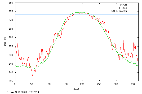
در نتیجه دمای سطح آب اقیانوس منجمد شمالی که سابقه اندازه گیری دماش بر میگرده به سال 1958 تاکنون، کاهش قابل ملاحظه یافته و باعث شده که وسعت یخ ها افزایش پیدا کنه.


Daily Mean Temperatures in the Arctic 1958 - 2013


meanT_2013.png


در نمودار بالا :

خط آبی= دمای انجماد آب

خط سبز: میانگین دمای سطح آب از سال 1958 تا 2013

خط قرمز= دمای ثبت شده در حال حاضر هست.

پس اطلاعات منتشر شده بر روی اینترنت 100 درصد واقعی - صحیح و البته بسیار خوشحال کننده است.:گل:

 
آخرین ویرایش:

Amir Mohsen

متخصص بخش هواشناسی
خوب این سایت ایتالیایی هم پیش بینی یک ماهه( اول سپتامبر لغایت 30 سپتامبر ) خودش رو در اولین روزهای سپتامبر منتشر کرده که خوندش خالی از لطف نیست:

تحلیل دماییش امیدوار کننده است:

اگر ایران رو از وسط به دو بخش تقسیم کنیم در نیمه غربی دمای هوا نرمال و در نیمه مرکزی-شرقی یک درجه خنکتر از نرمال خواهد بود

c4v87ugkon8q5lk62u0c.jpg


برای بخشهایی از شمال غرب هم بارش پیش بینی کرده در همین برهه زمانی.

برای مطالعه متن کامل مقاله مذکور بر روی لینک زیر کلیک نمایید:


http://www.isac.cnr.it/dinamica/projects/forecast_dpc/MONTHLY/month_201309.pdf
 

Amir Mohsen

متخصص بخش هواشناسی
پیش بینی فصلی هواشناسی روسیه!!!!!!!


SEASONAL FORECAST WITH 1-MONTH LEAD TIME
! Although this product is issued on regular basis it is important to be aware of its imperfection.
! Please take into account the skill maps to understand limitations of this forecast.
composite-tsrf-prob-glb-HMC.gif

composite-tsrf-prob-rus-HMC.gif

composite-prec-prob-glb-HMC.gif
composite-prec-prob-rus-HMC.gif


Amir Mohsen

متخصص بخش هواشناسی
جریانات در دریای کاسپین به شدت شمالی شده و بنظرم باید دوستان عزیز در سواحل غربی دریای کاسپین منتظر وزش باد شدید و طوفانی شدن دریا و تشدید بارشها باشند!!!!!!!!!!!!

20130908_17_14_det.gif
 

Amir Mohsen

متخصص بخش هواشناسی
[SIZE=+2][SIZE=+2]
Complete Track & SST
58.track.png


Current Track & SST
58.track.current.png


Forecast 925mb Wind Swath
58.windswath.png


Current Wind, SLP, and 500mb Analysis
58.slp.png
[/SIZE]​
[/SIZE]
 

Dr.ben

کاربر ويژه
سلام خدمت امیر محسن عزیز.
فعلا در رشت و جایی که ما هستیم سرعت وزش باد چندان محسوس نیست. بارون همچنان به شکل لایت در حال بارش هست.
 

Dr.ben

کاربر ويژه
درود دوستان عزیز

امروز خبری رو در سایت پیش بینی وضع هوای مشهد منتشر کردم مبنی بر افزایش وسعت 60 درصدی یخ های اقیانوس منجمد شمالی در مقایسه با سال گذشته که خبر بسیار شادی آفرینی برای بنده بود.:


مقایسه وضعیت گستره پوشش یخهای قطب شمال و اقیانوس منجمد شمالی ، آگوست 2012 با آگوست 2013

c8lkjclct91n1hsps6tp.jpg


خوشبختانه گستره پوشش برف و یخ در محدوده اقیانوس منجمد شمالی در تابستان امسال در مقایسه با سال گذشته در حدود 60 درصد افزایش یافته است.


خوب حالا ببینیم که چرا وسعت یخ های قطب شمال افزایش پیدا کرده!!!!

نقشه زیر آنومالی ارتفاع ژئوپتانسیل در تراز 500 میلی بار از ماه ژوئیه تا ماه آگوست رو نشون میده که همانطوریکه ملاحظه میکنید در منطقه گرینلند آنومالی منفی و کاهش ارتفاع در تراز 500 میلی بار بوضوح دیده میشه:


151.238.159.10.251.8.35.20.png


اینهم نقشه دمای محقق شده در ناحیه اقیانوس منجمد شمالی در طول همین دوره که به شدت کاهش پیدا کرده است:


151.238.159.10.251.8.38.12.png


در نتیجه دمای سطح آب اقیانوس منجمد شمالی که سابقه اندازه گیری دماش بر میگرده به سال 1958 تاکنون، کاهش قابل ملاحظه یافته و باعث شده که وسعت یخ ها افزایش پیدا کنه.


Daily Mean Temperatures in the Arctic 1958 - 2013


meanT_2013.png


در نمودار بالا :

خط آبی= دمای انجماد آب

خط سبز: میانگین دمای سطح آب از سال 1958 تا 2013

خط قرمز= دمای ثبت شده در حال حاضر هست.

پس اطلاعات منتشر شده بر روی اینترنت 100 درصد واقعی - صحیح و البته بسیار خوشحال کننده است.:گل:


ممنون از تفسیر کامل شما. امیر محسن جان به نظرتون این یه روند ادامه دار هست یا دوباره وضعیت پوشش برف به حالت سابق ( منظورم کاهش میزان پوشش برف هست) بر میگرده؟
 

Amir Mohsen

متخصص بخش هواشناسی
سلام خدمت امیر محسن عزیز.
فعلا در رشت و جایی که ما هستیم سرعت وزش باد چندان محسوس نیست. بارون همچنان به شکل لایت در حال بارش هست.

سلام بهزاد جان و تشکر از اطلاع رسانی خوب شما دوست خوبم.

ظاهرا از سمت استان اردبیل ،سرعت وزش باد افزایش یافته است:


The report was made 20 minutes ago, at 15:50 UTC
Wind 26 km/h from east/northeast
Temperature 16°C
Humidity 94%
Pressure 1016 hPa
Visibility 2000 m
Broken clouds at a height of 91 m
patches of fog


احتمالا از اواخر وقت امشب منطقه شما دریا طوفانی خواهد شد
 

Amir Mohsen

متخصص بخش هواشناسی
ممنون از تفسیر کامل شما. امیر محسن جان به نظرتون این یه روند ادامه دار هست یا دوباره وضعیت پوشش برف به حالت سابق ( منظورم کاهش میزان پوشش برف هست) بر میگرده؟

خواهش میکنم بهزاد عزیز

بنظرم این وضعیت تداوم خواهد داشت چون بارش شدید برف در این منطقه از شرق سیبری هم آغاز شده ، پس با این حساب شاخص SAI ( SNOW ADVANCED INDEX هم مثبت میشه و در نتیجه میشه به تقویت هوای سرد عرضهای شمالی و ظهور زمستان سرد و سخت در نیمکره شمالی امیدوار شد:

وضعیت فعلی بارش برف در شرق سیبری:

z14u5f9lbqrl8lu1auk.jpg


اینهم اطلاعاتی در مورد شاخص SNOW ADVANCED INDEX


Snow Advance Index: A New Tool for Predicting Winter’s Severity


Judah Cohen, PhD


November 14, 2011


Judah%20cropped.jpg


Snow Advance Index: A New Tool for Predicting Winter’s Severity

Researchers at AER have developed a new Snow Advance Index that could greatly improve the accuracy of winter seasonal forecasts. Based on research and testing, this index for the first time can accurately predict the severity of the upcoming winter. What makes this discovery so significant is that advances in seasonal forecasting have remained elusive, and for much of the United States seasonal forecasts are no more accurate today then they were decades ago.
Benefit to industry and government

Because weather impacts so many industries, this research and the inclusion of the Snow Advance Index in seasonal forecasts have direct benefit for businesses and government agencies that use long-range forecasts to optimize their operations and financial results and mitigate risk. Demonstrating this need, a recent report issued by the National Academy of Sciences on climate prediction concluded that more accurate climate forecasts would provide great benefit to society and would improve decision making from the agriculture to the energy sector.

Winter-Severity-Index-699x366.gif

Why has accurate seasonal forecasting been so difficult?

Significant improvements have been made in short term weather forecasting. People rely on the nightly broadcast of the seven day weather forecast, which is more often correct than not.
In contrast, making accurate seasonal forecasts continues to frustrate the large government forecast centers. Despite the use of ever more sophisticated climate models, the only demonstrable skill is that associated with the El Niño/Southern Oscillation (ENSO). Yet the temperature forecast accuracy related to ENSO is limited to western North America; and climate model forecasts for the Eastern US, Europe and East Asia remain no better than using past history or even a coin flip as a forecast tool.
Predicting the North Atlantic Oscillation or Arctic Oscillation (N/AO)

The scientific community acknowledges that a different climate phenomenon is strongly related to the weather in the Eastern US and Europe. It’s known as the North Atlantic Oscillation or Arctic Oscillation (N/AO) and is explained below.
Until now, the N/AO has been considered unpredictable; but this new Snow Advance Index developed at AER can, for the first time, predict the N/AO with a high degree of accuracy. Even more importantly, the Snow Advance Index predicts with unprecedented accuracy winter temperatures and thus the severity of winter weather in the Eastern US, Europe and East Asia. This is discussed below and shown in the Figure.
How the N/AO impacts temperatures in Eastern US, Europe and East Asia

The N/AO can be thought of as a winter severity index.

  • When the N/AO index is high, winters in the Eastern US, Europe and East Asia are milder or less severe.

  • In contrast, when the N/AO index is low, winters in the Eastern US, Europe and East Asia are more severe with increased bouts of cold weather and snowstorms.
The ability of forecasters to predict the N/AO, or winter severity index, would provide significantly improved temperature forecasts for the Eastern US, Europe and East Asia. Research at AER and other institutions has shown a statistical relationship between the Eurasian snow cover extent in October and the winter N/AO or the severity of winter weather.

  • When there is more Eurasian snow cover in October, the following winter N/AO is low and there is an increased frequency of severe weather in the mid-latitudes.

  • When there is less Eurasian snow cover in October, the following winter N/AO is high and there is a decrease in the frequency of severe weather in the mid-latitudes.
AER Researchers demonstrate how the Snow Advance Index predicts the N/AO

Until now only a moderate relationship has been demonstrated. However in a paper published in Geophysical Research Letters by myself and Justin Jones, a new Snow Advance Index is developed that is derived not from October mean snow cover extent, but rather as a function of how slowly or quickly the snow cover advances across Eurasia in October. This new Snow Advance Index is highly correlated with the N/AO or winter severity index (see Figure).

  • [HIGHLIGHT]When snow cover advances rapidly across Eurasia in October, this is an indication that the upcoming winter will be more severe for the Eastern US, Europe and East Asia.

  • When snow cover advances slowly across Eurasia in October this is an indication that the upcoming winter will be milder for the Eastern US, Europe and East Asia[/HIGHLIGHT].
Using the Snow Advance Index to improve Forecast Skill

Hindcasts or back testing of this new Snow Advance Index demonstrates great potential in both predicting the N/AO and improving winter temperature forecasts for much of the large population centers of the Northern Hemisphere.
This new Snow Advance Index will be used for the first time in the AER winter forecast for the winter season of 2011-2012.
The link between the N/AO and Winter Severity

The N/AO can be thought of as an index of high latitude blocking.

  • When the N/AO is high, high latitude blocking is much less frequent. The Jet Stream flows quickly from west to east carrying weather systems along quickly and acts as a divide between cold air to the north and warm air to the south. The Eastern US, Europe and East Asia, which lie in the mid-latitudes, experience long stretches of mild weather, as they remain cut off from cold, Arctic air masses.

  • When the N/AO is low, high latitude blocking is more frequent. The flow of air in the atmosphere is impeded or becomes blocked and the Jet Stream is diverted from its normal trajectory and meanders north and south around the high latitude blocking. Mixing of air masses occurs with warm air flowing north into the Arctic and cold air flowing south into the midlatitudes. The Eastern US, Europe and East Asia, which lie in the mid-latitudes experience more severe winter weather, as Arctic air masses repeatedly drive southward. Furthermore, the mixing of warm and cold air masses fuel storms and with more abundant cold air, the precipitation from these storms often falls as snow.
 
آخرین ویرایش:
وضعیت
موضوع بسته شده است.
بالا