-
توجه: در صورتی که از کاربران قدیمی ایران انجمن هستید و امکان ورود به سایت را ندارید، میتوانید با آیدی altin_admin@ در تلگرام تماس حاصل نمایید.
You are using an out of date browser. It may not display this or other websites correctly.
You should upgrade or use an alternative browser.
You should upgrade or use an alternative browser.
تجزیه و تحلیل وضعیت جوی در سال زراعی 93-94 /فصل اول( مهر- آبان-آذر)
- شروع کننده موضوع heaven1
- تاریخ شروع
- وضعیت
- موضوع بسته شده است.
Amir-Hossein
کاربر ويژه
Amir-Hossein
کاربر ويژه
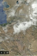
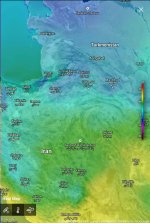
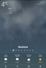
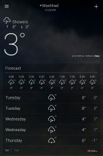
این یاهو ودر عجب تصاویر زیبایی برای زمینه ش استفاده میکنه
Sent from my MediaPad X1 7.0 using Tapatalk
Sent from my MediaPad X1 7.0 using Tapatalk
پیوست ها
-
 uploadfromtaptalk1415087625854.jpg144.4 کیلوبایت · بازدیدها: 10
 -
 uploadfromtaptalk1415087670919.jpg191.9 کیلوبایت · بازدیدها: 8
 -
 uploadfromtaptalk1415087704326.jpg318.1 کیلوبایت · بازدیدها: 8
 -
 uploadfromtaptalk1415087748669.jpg160.8 کیلوبایت · بازدیدها: 8
 -
 uploadfromtaptalk1415087786399.jpg103.3 کیلوبایت · بازدیدها: 9
Amir Mohsen
متخصص بخش هواشناسی
Amir Mohsen
متخصص بخش هواشناسی
بارشها از امروز در منطقه ما تشدید میشن و این روند خدا رو شکر تا 54 ساعت آینده همچنان ادامه خواهد یافت:


فرودگاه اردبیل نشون داده استعداد بی نظیری در کسب کمینه های پایین داره ، معمولا بارش فرودگاه اردبیل این چند ساله که دقت کردم کمتر ازشهر اردبیله و سرماش بیشتر ولی با وجود اینکه پوشش برفش معمولا کمه ولی اغلب کمینه هاش از همهمناطق استان اردبیل پایین تره
اما این دفعه عکسش اتفاق افتاده یعنی فرودگاه اردبیل پوشش برفش بیشتر ازسایر نقاط اردبیله ، همه اینها رو گفتم تا بگم ایستگاه فرودگاه اردبیل با توجه 1-به پوشش مناسب برفش 2- باتوجه به اقلیم خاصش (یک دشت وسیع که مابین دو رشته کوه تالش در شرق و بلندیهای سبلان درغرب قرار گرفته و این دشتهای بین دو رشته کوه بهترین حالت رو برای کسب کمینه پایین دارند)3 - و با توجه به سرمای شمالی این چند روز با اختلاف فاحشی( در حد اختلاف دهلی نو با مسکو!) نسبت به سردسیرات دیگه کشور در صدر خواهد بود حتی اجازه نفس کشیدن هم به رقبا نخواهد داد
اما این دفعه عکسش اتفاق افتاده یعنی فرودگاه اردبیل پوشش برفش بیشتر ازسایر نقاط اردبیله ، همه اینها رو گفتم تا بگم ایستگاه فرودگاه اردبیل با توجه 1-به پوشش مناسب برفش 2- باتوجه به اقلیم خاصش (یک دشت وسیع که مابین دو رشته کوه تالش در شرق و بلندیهای سبلان درغرب قرار گرفته و این دشتهای بین دو رشته کوه بهترین حالت رو برای کسب کمینه پایین دارند)3 - و با توجه به سرمای شمالی این چند روز با اختلاف فاحشی( در حد اختلاف دهلی نو با مسکو!) نسبت به سردسیرات دیگه کشور در صدر خواهد بود حتی اجازه نفس کشیدن هم به رقبا نخواهد داد
Amir Mohsen
متخصص بخش هواشناسی
Amir Mohsen
متخصص بخش هواشناسی
علیرغم اینکه فرودگاه در چند آپدیت اخیرش وضعیت جوی روفقط ابری اعلام میکنه ولی اینجا تو غرب بارش از دیشب ساعت 2 که شروع شده هنوز قطع نشده و همچنان مطلوب و پاییزی میباره

Amir Mohsen
متخصص بخش هواشناسی
Amir Mohsen
متخصص بخش هواشناسی
| THE 300 / 200 MB CHART |
METEOROLOGIST JEFF HABY
One of a forecaster's first thoughts when confronted with the 300/200 mb chart is the jet stream. The jet stream is a high velocity river of air that flows completely around the Earth at the mid-latitudes. During winter, the jet core is located generally closer to 300 millibars since the air is more cold and dense in the vicinity of the jet stream during the cool season. The 200 millibar chart is used for the jet stream in the warm season but either chart in most instances will suffice. Many hot air balloonists have tried to ride this river of air around the world with not much success for most. The river of air is not continuous. Embedded within the jet stream are higher velocity jet streaks. Jet streaks are segments of faster wind speed within the jet stream.
At 300 mb, the air density is much smaller than near the surface. A 100-knot wind at the 200/300 millibar level does not feel as strong as a 100 knot wind at the surface. Even though the density is smaller, these air currents have the power to drive the movement of storm systems and build troughs and ridges.
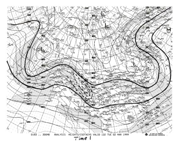
One jet streak can turn a beautiful Monday into a severe storm Tuesday, as we will see in an example later. Troughs and ridges are not only carved by warm air and cold air advection but also by the high momentum air of jet streaks. A significant jet streak has winds over 100 knots. Look at the 300 mb chart in this section labeled "Time 1". A jet streak exists from Colorado to Montana. The highest wind speeds in the jet streak (aka jet core, jet surge) are 130 knots (150 miles per hour) in southern Wyoming.
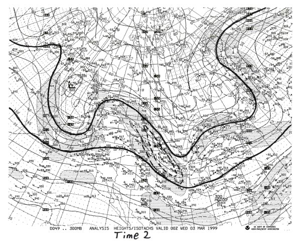
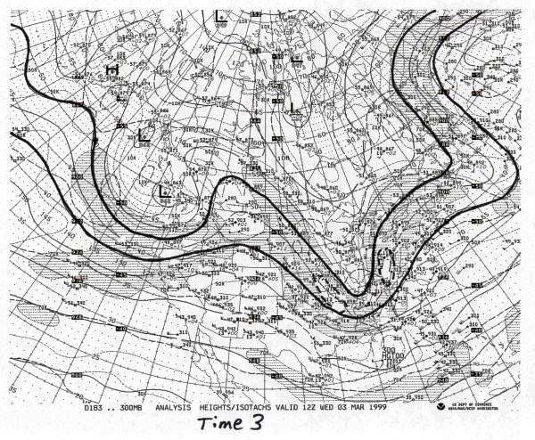
Parcels within the jet streak are diving to the southeast. The air's momentum forces a trough to develop across the Central US. In "Time 2", the chart from 12 hours later, the jet streak has moved further to the southeast and the associated trough is becoming more amplified. At "time 3" the jet streak has turned the corner and is in the base of the trough. The trough is at maximum amplification. The trough will now move to the east and eventually to the northeast. It is difficult to determine the four quadrants of a jet streak when one "turns the corner". Divergence and rising motion are strongest to the north of the jet axis, such as in Tennessee during highly curved jet streaks. RULE OF THUMB: If a jet streak exists on the left side of a trough and winds are stronger to the left of the trough (as it is in our example in "Time 1"), the trough will become more amplified with time and will "dig" in a southerly direction. If a jet streak exists on the right side of a trough and winds are stronger to the right of the trough, the trough will become less amplified with time and "lift out" in a northeasterly direction. If the winds are about the same on each side of the trough, it will stay at about the same amplification. This knowledge will make you a better forecaster! A jet streak progression is shown below.
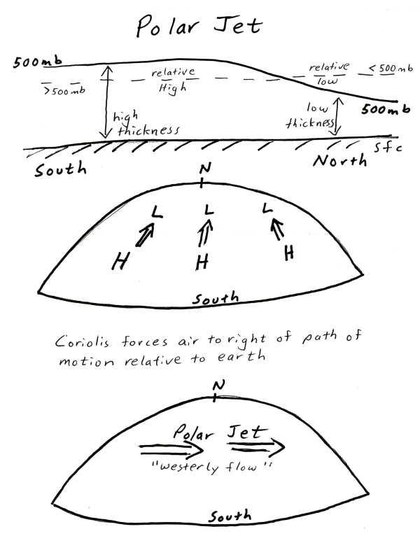
The jet stream is useful for the prediction of temperature. The jet stream divides colder air to the north from warmer air to the south. The transition between temperatures on each side of the jet is very abrupt. Heights are higher to the south of the jet and lower to the north. In the upper levels, this creates relatively high heights to the south of the jet and relatively low heights to the north. The Pressure Gradient Force flows from a southerly to northerly direction. However, the Coriolis force shifts the wind flow to the right of the path of motion. Therefore, the jet stream flows from the west to east. When a trough builds over a region it often indicates cooler temperatures due to cloudier weather and northerly winds. A ridge builds by low level (between the surface and 700-mb) warm air advection and upper level forcing (negative vorticity). Air in a ridge is sinking and is thus expanding and creating higher heights. Therefore, temperatures are warmer than normal in a ridge due to warmer temperatures and sunnier weather. This is especially true when a ridge occurs in high latitudes. Below is a diagram showing the development of the polar jet and the wind pattern the PGF and Coriolis produce.
Certain regions of jet streaks are more favorable for rising or sinking air. Where convergence occurs in the upper levels, sinking motion results. Where divergence (evacuation of mass) occurs in the upper levels, rising motion result. Convergence and divergence in a jet streak is caused by an imbalance of forces as a parcel accelerates into a jet streak then decelerates out of the jet streak. The depiction below shows the balance and imbalance of forces in a jet streak. Lets look at each of the 5 numbers and letters.
MOTION WITHIN A JET STREAK
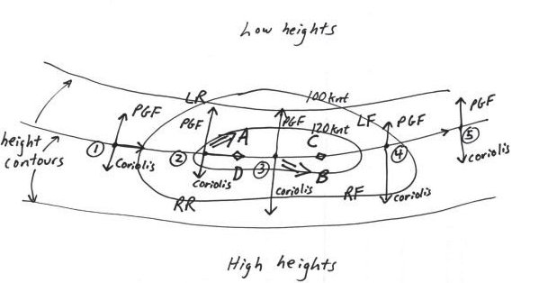
(1) Pressure Gradient Force and Coriolis are in balance. Wind is geostrophic (parallel to height contours)
(2) Parcel enters region of higher wind speed. This increases the Pressure gradient force at the same time the Coriolis has not been changed much. Wind will tend to flow toward the longest vector, which is the PGF. This causes convergence in the Left Rear Quad (sinking air at letter A) and divergence in the Right Rear Quad (rising air at letter D). The tropopause is just above jet stream level. Convergence at the jet stream level forces air to sink because the highly stable tropopause prevents air from rising.
(3) The Coriolis once again balances the Pressure Gradient Force.
(4) As a parcel leaves the jet streak it must decelerate. The Pressure Gradient Force weakens at the same time the Coriolis has not had time to adjust and decrease. This causes convergence in the Right Front Quad (sinking air at letter B) and divergence in the Left Front Quad (rising air at letter C).
(5) Pressure Gradient Force and Coriolis once again balance
This example has been for a jet streak in a zonal flow. A jet streak in a curved flow, such as the case when a jet streak is in the base of a trough, will have divergence and rising air to the north of the jet and convergence and sinking air to the south of the jet.
The jet stream is a powerful forecasting tool. Not that it can give exact highs/ lows/ and precipitation chances, but because it gives information such as when to expect the next storm system and whether temperatures will be above or below normal. It gives clues to how the upper levels will promote rising air or sinking air. It gives clues to the character of the next storm system. Jet streaks alone provide much information of how a trough or ridge will develop over the next couple of days.
WHAT TO LOOK FOR ON 300/250/200 chart:
(1) Jet stream
*The jet stream is a river of air with segments of higher speed winds embedded within the mean flow
*Areas North of jet stream tend to have cooler than normal temperatures especially in the mid-latitudes
*Areas South of jet stream tend to have warmer than normal temperatures, especially in higher latitudes
(2) Jet Streaks
*Rising air occurs in the right rear and left front quadrants of jets
*Sinking air occurs in the left rear and right front quadrants of jets
*Rising air occurs north of jet axis if jet is in a highly curved flow
*Winds over 120 miles per hour constitute a significant jet streak
*Upper level divergence enhances rising air, especially if warm air advection is occurring in lower levels of atmosphere
(3) General trough/ridge pattern
*Momentum of jet stream carves the trough ridge pattern. If the jet stream winds are greater on the LEFT side of a trough, the trough will become more amplified and move further south. If the jet stream winds are greater on the RIGHT side of a trough, the trough will become less amplified with time and move further north.
CURRENT 300 MB INITIALIZATION
CURRENT 250 MB ANALYSIS
CURRENT 200 MB ANALYSIS
Amir Mohsen
متخصص بخش هواشناسی
این نقشه برای ساعت 10:30امروز صبج و جت استریم قطبی و جنب حاره ای کاملا روی ایران با هم برخوردکرده اند و wind shear مطلوبی رو فراهم کرده اند، اگه به گزینه isotachs 300 نگاه کنیدمی بینی که jetstreak جنب حاره ای با افزایش سرعت 60 نات میتونه به عمیق تر شدن ناوه و ریزش هوای سرد به منطقه ما کمک شایان توجهی کنه و اون خطوط بنفش و آبی هم دامنه ریزش هوای سرد رو نشون میدن ، هر وقت اون خط بنفش به مشهد برسه قطعا بارشها بیشتر به شکل برف نمود خواهد داشت:


Amir Mohsen
متخصص بخش هواشناسی
[h=3]Waves on the jet stream - upper ridges and troughs back to Contents The Polar jet stream is readily picked out on upper-air wind charts, as in the example below. This is a Global Forecasting System (GFS) forecast model chart for windspeeds and direction of flow at the 300 hPa pressure level; in other words at an altitude a little higher than the summit of Everest and not far beneath the Tropopause. Highest winds are red, weakest blue. The most obvious thing that immediately catches the attention is that the jet stream doesn't always run in a straight, west-east line, even though that's the prevailing wind direction in the Northern Hemisphere.
 Graphic: model output plot - Wetterzentrale; annotation: author Instead, it curves north and south in a series of wavelike lobes, any one of which can half-cover the Atlantic. These large features, which are high-pressure ridges and low-pressure troughs, are known as Longwaves or Rossby Waves, of which there are several present at any given time along the Polar Front. A key ingredient in their formation is perturbation of the upper Troposphere as the air travels over high mountain ranges, such as the Rockies. Warm air pushing northwards delineates the high-pressure ridges. Cold air flooding southwards forms the low-pressure troughs. The two components to jet stream flow - west-east and north-south - are referred to as zonal and meridional flows respectively. The straighter a west-east line the jet stream takes, the more zonal it is said to be. The greater the north-south meandering movement, the more meridional it is said to be.
In addition to the Longwaves, there are similar, but much smaller ridges and troughs, known as Shortwaves. The chart above also shows how, locally, the jet stream can split in two around a so-called cut-off upper high or low, reuniting again downstream. Longwaves, shortwaves and cut-off highs and lows all have a strong bearing on the weather to be expected at ground-level. Several factors are important with regard to the Polar jet stream and its effect on weather. Again taking the UK as an example, the position of the Polar jet stream is of paramount importance. If it sits well to the north of the UK, residents can expect mild and breezy weather, and occasional settled spells. The Atlantic storms are passing by to the north, so they only clip north-western areas. However, if the Polar jet stream runs straight across the UK then the depressions will run straight over the country, with wet, stormy weather likely. If it sits to the south, depressions take a much more southerly course, bringing storms to Continental Europe, and, in winter, the risk of heavy snow for the southern UK, as the prevailing winds associated with low pressure systems that are tracking to the south of the UK will be from the east, thereby pulling in colder continental air.
 above: typical zonal (red) and meridional (orange) jet stream paths superimposed on part of the Northern Hemisphere. Extreme meridionality can bring very cold air flooding a long way south from the Arctic while warm air is able in a different sector to force its way into the far north. The most extreme version of this I have seen was on the morning of November 28th 2010: at 0600, parts of Powys (Mid Wales) were down to -18C, whilst at the same time Kangerlussuaq, within the Arctic Circle in Western Greenland, was at +9C - or 27C warmer!! Graphic: author
In highly zonal conditions, weather-systems move along rather quickly, giving rise to changeable weather. However, in highly meridional conditions, the Longwaves can slow down in their eastwards progression to the point of stalling, to form what are known as blocks. When a block forms, whatever weather-type an area is experiencing will tend to persist. During some winters, for example, a blocking ridge forms in the mid-Atlantic, with high pressure extending from the Azores all the way up towards Greenland. Provided the block is far enough west, it can induce a cold northerly to easterly airflow over NW Europe, a synoptic pattern that brings cold weather and, in recent winters, heavy snowfalls. To complete this section, here are a couple of Flash animations of different jet stream patterns by Skeptical Science team-member 'jg' that illustrate how the waves progress eastwards. First, zonal, with the longwaves moving through briskly: Next: meridional - the longwaves are progressing eastwards much more slowly in general. In a blocked scenario, imagine the 'pause' button has been pressed and the whole lot has stopped for a while: Now, let's move onto some of the important weather-forcing mechanisms that are associated with the jet stream and its wave-patterns. [h=3]Positive vorticity - a driver of severe weather - and the jet stream back to Contents Another important factor associated with any jet stream is vorticity advection. The jet flowing around a lobe of cold polar air (an upper Longwave or Shortwave trough), orientated north-south, first runs S, then SE, then E, then NE, then N - i.e. its motion is anticlockwise, or cyclonic. Watch a floating twig in a slow-moving river. As it turns a bend it will slowly spin. It's spinning because the water upon which it floats is spinning - it has vorticity. You can't necessarily see the water doing this but the floating twig gives the game away! Vorticity is a measure of the amount of rotation (i.e. the intensity of the "spin") at a given point in a fluid or gas. And, in the air rounding an upper trough, anticlockwise vorticity is induced. This is known as Cyclonic Vorticity (or frequently as Positive Vorticity).
 above: how the eastwards progression of upper ridges and troughs affects vorticity which in turn affects lift in airmasses. Areas of positive vorticity advection (PVA) occur ahead of approaching troughs, aiding severe weather development, whereas areas of negative vorticity advection (NVA) cause air to sink, inhibiting developments. Graphic: jg.
Positive vorticity in the upper Troposphere encourages air at lower levels to ascend en masse. Rising air encourages deepening of low-pressure systems, assists convective storm development and so can lead to severe weather such as heavy precipitation and flooding. As an upper trough moves in, air with positive vorticity is advected ahead of its axis in the process known as positive vorticity advection, usually abbreviated to PVA. Thus, to identify areas of PVA when forecasting, look on the upper air charts for approaching upper Longwave or Shortwave troughs: PVA will be at its most intense just ahead of the trough and that is where the mass-ascent of air will most likely occur. The reverse, anticyclonic or negative vorticity advection (NVA) will occur between the back of the trough and crest of an upper ridge, due to the same process but with a clockwise (anticyclonic) spinning motion induced into the air as it runs around the crest of the ridge. In such areas air is descending en masse instead of ascending. Descent is very adept at killing off convection and cyclonic storm development. Thus as the upper trough passes, severe weather becomes increasingly unlikely to occur. [h=3]Wind-shear - a driver of severe weather - and the jet stream back to Contents Wind-shear, involving changes in wind speed and/or direction with height, is an important factor in severe weather forecasting. Shear in which windspeed increases occur with height (speed-shear) is common, as you will notice when climbing a mountain: a breeze at the bottom can be a near-gale at summit-level. But in the upper troposphere the proximity of the Polar jet stream can lead to incredibly strong winds. Speed-shear is important in convective storm forecasting as it literally whisks away the "exhaust" of a storm, thus helping to prolong it: the storm's updraught and precipitation-core (downdraught) are kept apart, instead of the downdraught choking the updraught. It's a bit like an open fire drawing well. The strongest speed-shear occurs when the jet is racing overhead. In this environment, cumulonimbus anvils may stretch for many miles downstream due to the icy cirrus of the anvil being dragged downwind. When there's hardly any speed-shear the storm-tops have a much more symmetrical shape to them. Directional shear basically means that winds are blowing in a different directions at different heights from the surface. Drawing from my experience in weather-photography, I know that a warm early summer's day where the synoptic pressure-pattern gives a light northerly airflow at say 850 hPa, coupled with some instability, is a consistently productive set-up for thunderstorms and funnel-clouds. Why? Well, I live ten miles due east of the Welsh coast, surrounded by hill-country. As warm sunlight heats the lower Troposphere over the hills, air will begin to rise by convection: at the same time, a sea-breeze will set in, flowing west to east inland from the coast. These two air-currents will meet - or converge - along a linear front somewhere over the hills. Because the sea-breeze is relatively cool, along the front it undercuts and lifts the warm air, strongly aiding convective storm initiation. In addition, the developing storms are moving north-south along their steering flow but the air flowing into the western side of their updraughts - the sea-breeze - is coming in at right angles to that. That's a lot of low-level, rotation-inducing directional shear, more than sufficient for funnel-cloud development, something I have witnessed along sea-breeze fronts on a number of occasions. In situations where major instability (and therefore the potential for severe storms) is present, directional shear can be of critical importance in the formation of tornadic supercells, in which the updraught is rotating strongly from near ground-level all the way up to the top of the storm-cloud. These tend to be the most violent members of the thunderstorm family because of the persistence and strength of their updraughts.
 above: speed-shear revealed by a convective shower-cloud. High-speed upper winds are dragging the upper parts of the cloud well over to the R. below: speed and directional-shear revealed by a small supercell thunderstorm: the updraught is tilted R-wards so that the rain is falling well over to the R, several miles downwind from the updraught base. The seat of the updraught is indicated by the dramatically lowered rotating wall-cloud reaching halfway down to the sea from the overall cloud-base. This storm persisted for over 90 minutes as it tracked across over 100km of the seas and mountains of Wales. Photos: author.

[h=3]Jetstreak development along the jet stream - a driver of severe weather back to Contents
Within the overall, circumglobal ribbon-like wind-field of the Polar jet stream, there occur local sections with much stronger winds than elsewhere. These are called jetstreaks. They form in response to localised but major temperature-gradients, and they move around the lobes, following the troughs and ridges, and affect these in their passing, strengthening them as they move in and weakening them as they move out. They also influence the weather below even if moving in a fairly straight line when there are few longwave ridges/troughs about.
 Graphic: model output plot - Wetterzentrale; annotation: author
Fast jetstreaks with winds as high as 200 knots pull in air upstream (to their west) at what is called an Entrance Region and throw it out downstream (to their east) at what is called an Exit Region. These are further subdivided, as in the diagram above, into Left (to the north) and Right (to the south). Because the behaviour of air currents is determined by the interaction of the Coriolis effect and the pressure-gradient, the Right Entrance and Left Exit regions of jetstreaks are areas where winds aloft diverge, allowing air below to rise. This in turn further encourages storm development. In Right Exit and Left Entrance regions, the opposite occurs, with upper-level winds converging leading to air sinking and inhibiting storm formation. The reason why, in terms of storm development, it is divergence as opposed to convergence that is important at height (the opposite being the case at low levels) is because converging air at height cannot go upwards because of the effective ceiling provided by the Tropopause. There is only one vertical direction in which the air can freely go - downwards. What this means on the ground is that if your area is near to a developing low pressure system or a convectively-unstable airmass and an upper trough is approaching, with a jetstreak heading towards the base of the trough with its Left Exit region heading straight for where you are, you have the ingredients for explosive severe weather development. The low can deepen intensively to bring a storm system with tightly-packed surface isobars giving severe gales and flooding rains. Alternatively, convection may lead to the development of severe thunderstorms, because that critical combination of mass-ascent and high shear is in place.

In addition to the Longwaves, there are similar, but much smaller ridges and troughs, known as Shortwaves. The chart above also shows how, locally, the jet stream can split in two around a so-called cut-off upper high or low, reuniting again downstream. Longwaves, shortwaves and cut-off highs and lows all have a strong bearing on the weather to be expected at ground-level. Several factors are important with regard to the Polar jet stream and its effect on weather. Again taking the UK as an example, the position of the Polar jet stream is of paramount importance. If it sits well to the north of the UK, residents can expect mild and breezy weather, and occasional settled spells. The Atlantic storms are passing by to the north, so they only clip north-western areas. However, if the Polar jet stream runs straight across the UK then the depressions will run straight over the country, with wet, stormy weather likely. If it sits to the south, depressions take a much more southerly course, bringing storms to Continental Europe, and, in winter, the risk of heavy snow for the southern UK, as the prevailing winds associated with low pressure systems that are tracking to the south of the UK will be from the east, thereby pulling in colder continental air.

In highly zonal conditions, weather-systems move along rather quickly, giving rise to changeable weather. However, in highly meridional conditions, the Longwaves can slow down in their eastwards progression to the point of stalling, to form what are known as blocks. When a block forms, whatever weather-type an area is experiencing will tend to persist. During some winters, for example, a blocking ridge forms in the mid-Atlantic, with high pressure extending from the Azores all the way up towards Greenland. Provided the block is far enough west, it can induce a cold northerly to easterly airflow over NW Europe, a synoptic pattern that brings cold weather and, in recent winters, heavy snowfalls. To complete this section, here are a couple of Flash animations of different jet stream patterns by Skeptical Science team-member 'jg' that illustrate how the waves progress eastwards. First, zonal, with the longwaves moving through briskly: Next: meridional - the longwaves are progressing eastwards much more slowly in general. In a blocked scenario, imagine the 'pause' button has been pressed and the whole lot has stopped for a while: Now, let's move onto some of the important weather-forcing mechanisms that are associated with the jet stream and its wave-patterns. [h=3]Positive vorticity - a driver of severe weather - and the jet stream back to Contents Another important factor associated with any jet stream is vorticity advection. The jet flowing around a lobe of cold polar air (an upper Longwave or Shortwave trough), orientated north-south, first runs S, then SE, then E, then NE, then N - i.e. its motion is anticlockwise, or cyclonic. Watch a floating twig in a slow-moving river. As it turns a bend it will slowly spin. It's spinning because the water upon which it floats is spinning - it has vorticity. You can't necessarily see the water doing this but the floating twig gives the game away! Vorticity is a measure of the amount of rotation (i.e. the intensity of the "spin") at a given point in a fluid or gas. And, in the air rounding an upper trough, anticlockwise vorticity is induced. This is known as Cyclonic Vorticity (or frequently as Positive Vorticity).

Positive vorticity in the upper Troposphere encourages air at lower levels to ascend en masse. Rising air encourages deepening of low-pressure systems, assists convective storm development and so can lead to severe weather such as heavy precipitation and flooding. As an upper trough moves in, air with positive vorticity is advected ahead of its axis in the process known as positive vorticity advection, usually abbreviated to PVA. Thus, to identify areas of PVA when forecasting, look on the upper air charts for approaching upper Longwave or Shortwave troughs: PVA will be at its most intense just ahead of the trough and that is where the mass-ascent of air will most likely occur. The reverse, anticyclonic or negative vorticity advection (NVA) will occur between the back of the trough and crest of an upper ridge, due to the same process but with a clockwise (anticyclonic) spinning motion induced into the air as it runs around the crest of the ridge. In such areas air is descending en masse instead of ascending. Descent is very adept at killing off convection and cyclonic storm development. Thus as the upper trough passes, severe weather becomes increasingly unlikely to occur. [h=3]Wind-shear - a driver of severe weather - and the jet stream back to Contents Wind-shear, involving changes in wind speed and/or direction with height, is an important factor in severe weather forecasting. Shear in which windspeed increases occur with height (speed-shear) is common, as you will notice when climbing a mountain: a breeze at the bottom can be a near-gale at summit-level. But in the upper troposphere the proximity of the Polar jet stream can lead to incredibly strong winds. Speed-shear is important in convective storm forecasting as it literally whisks away the "exhaust" of a storm, thus helping to prolong it: the storm's updraught and precipitation-core (downdraught) are kept apart, instead of the downdraught choking the updraught. It's a bit like an open fire drawing well. The strongest speed-shear occurs when the jet is racing overhead. In this environment, cumulonimbus anvils may stretch for many miles downstream due to the icy cirrus of the anvil being dragged downwind. When there's hardly any speed-shear the storm-tops have a much more symmetrical shape to them. Directional shear basically means that winds are blowing in a different directions at different heights from the surface. Drawing from my experience in weather-photography, I know that a warm early summer's day where the synoptic pressure-pattern gives a light northerly airflow at say 850 hPa, coupled with some instability, is a consistently productive set-up for thunderstorms and funnel-clouds. Why? Well, I live ten miles due east of the Welsh coast, surrounded by hill-country. As warm sunlight heats the lower Troposphere over the hills, air will begin to rise by convection: at the same time, a sea-breeze will set in, flowing west to east inland from the coast. These two air-currents will meet - or converge - along a linear front somewhere over the hills. Because the sea-breeze is relatively cool, along the front it undercuts and lifts the warm air, strongly aiding convective storm initiation. In addition, the developing storms are moving north-south along their steering flow but the air flowing into the western side of their updraughts - the sea-breeze - is coming in at right angles to that. That's a lot of low-level, rotation-inducing directional shear, more than sufficient for funnel-cloud development, something I have witnessed along sea-breeze fronts on a number of occasions. In situations where major instability (and therefore the potential for severe storms) is present, directional shear can be of critical importance in the formation of tornadic supercells, in which the updraught is rotating strongly from near ground-level all the way up to the top of the storm-cloud. These tend to be the most violent members of the thunderstorm family because of the persistence and strength of their updraughts.


[h=3]Jetstreak development along the jet stream - a driver of severe weather back to Contents
Within the overall, circumglobal ribbon-like wind-field of the Polar jet stream, there occur local sections with much stronger winds than elsewhere. These are called jetstreaks. They form in response to localised but major temperature-gradients, and they move around the lobes, following the troughs and ridges, and affect these in their passing, strengthening them as they move in and weakening them as they move out. They also influence the weather below even if moving in a fairly straight line when there are few longwave ridges/troughs about.

Fast jetstreaks with winds as high as 200 knots pull in air upstream (to their west) at what is called an Entrance Region and throw it out downstream (to their east) at what is called an Exit Region. These are further subdivided, as in the diagram above, into Left (to the north) and Right (to the south). Because the behaviour of air currents is determined by the interaction of the Coriolis effect and the pressure-gradient, the Right Entrance and Left Exit regions of jetstreaks are areas where winds aloft diverge, allowing air below to rise. This in turn further encourages storm development. In Right Exit and Left Entrance regions, the opposite occurs, with upper-level winds converging leading to air sinking and inhibiting storm formation. The reason why, in terms of storm development, it is divergence as opposed to convergence that is important at height (the opposite being the case at low levels) is because converging air at height cannot go upwards because of the effective ceiling provided by the Tropopause. There is only one vertical direction in which the air can freely go - downwards. What this means on the ground is that if your area is near to a developing low pressure system or a convectively-unstable airmass and an upper trough is approaching, with a jetstreak heading towards the base of the trough with its Left Exit region heading straight for where you are, you have the ingredients for explosive severe weather development. The low can deepen intensively to bring a storm system with tightly-packed surface isobars giving severe gales and flooding rains. Alternatively, convection may lead to the development of severe thunderstorms, because that critical combination of mass-ascent and high shear is in place.
Amir Mohsen
متخصص بخش هواشناسی
وضع هوای گلمکان چناران
هوای حاضر ساعت: ۱۲:۴۵
پیش بینی ۳ روز آینده
هوای حاضر ساعت: ۱۲:۴۵
پیش بینی ۳ روز آینده

۴° c بارش برف جهت باد: جنوب شرقی |

سرعت باد: ۴ متر بر ثانیه, ۱۴ کیلومتر بر ساعت نم نسبی: % ۹۷ دید افقی: ۶۰۰۰متر بارندگی 24 ساعت گذشته: ۶.۴ میلیمتر بیشینه دما در 24 ساعت گذشته: ۱۸° c کمینه دما در 24 ساعت گذشته: ۴° c |

| � |
Amir Mohsen
متخصص بخش هواشناسی
فورکا میگه ساعت 3 بعد از ظهر وضعیت بارش اینطوریه


Amir Mohsen
متخصص بخش هواشناسی
Amir Mohsen
متخصص بخش هواشناسی
جی اف اس تا 48 ساعت آینده:


Amir Mohsen
متخصص بخش هواشناسی
تجمعی برف تا 54 ساعت اینده:


Amir Mohsen
متخصص بخش هواشناسی
تجمعی برف بر اساس هواشناسی کانادا:


- وضعیت
- موضوع بسته شده است.

