• توجه: در صورتی که از کاربران قدیمی ایران انجمن هستید و امکان ورود به سایت را ندارید، میتوانید با آیدی altin_admin@ در تلگرام تماس حاصل نمایید.

مباحث عمومی هواشناسی تابستان 1393

وضعیت
موضوع بسته شده است.

Amir Mohsen

متخصص بخش هواشناسی
ژانویه 1972 هم خیلی خیلی سرد بوده و ما یک دمای کمینه 27- در مشهد داشتیم:


xsi6n2t7if3x.jpg


rmbq2a5dagbt.jpg


مشهد در دسامبر 1971 در حدود 77.4 میلیمتر - ژانویه 1972 59.5 میلیمتر - فوریه 44.4 میلیمتر- مارچ: 66 میلیمتر بارش داشته!!!!!!!!!!!!!!! که همه اینها بارش بیشتر از نرمال محسوب میشند!!!

لانینا هم لانینا های قدیم !!!!!!!!!!!!
 

Amir Mohsen

متخصص بخش هواشناسی
وضعیت شاخص NAO در ماههای زمستان سال 1972


1972 1 -0.19 1972 2 -0.08 1972 3 0.35 1972 4 -0.38

در سال 1974 :

1974 1 1.05 1974 2 -0.60 1974 3 -0.43

اینهم وضعیت AO :


i9e7sea5o3j7.jpg
 

Amir Mohsen

متخصص بخش هواشناسی
حالا آدم میمونه النینو بهتره یا لانینا!!!

AO و NAO منفی مناسبه یا مثبت یا اصلا فاز خنثی مثل بالا!
 

DR WHO

کاربر ويژه
با اجازه بزرگترها هيچكدوم :خنده1:

سرماى 2008 از نوع بلاكينگ امگا بود و سرماى فرين امسال از نوع دوقطبىimage.jpg
 

Amir Mohsen

متخصص بخش هواشناسی
نقشه های بالا یک چیز رو ثبت میکنه و اون این هست که اگه یک سال سرد باشه هیچ دلیلی وجود نداره که سال بعدش هم سرد نباشه و انتظار گرما داشته باشیم!

اتمسفر خیلی پیچیده تر از این حرفهاست که بخوایم خیلی راحت در موردش اظهار نظر کنیم!
 

DR WHO

کاربر ويژه
نقشه های بالا یک چیز رو ثبت میکنه و اون این هست که اگه یک سال سرد باشه هیچ دلیلی وجود نداره که سال بعدش هم سرد نباشه و انتظار گرما داشته باشیم!

اتمسفر خیلی پیچیده تر از این حرفهاست که بخوایم خیلی راحت در موردش اظهار نظر کنیم!

نتايج بررسي توزيع بي هنجاري بارش فصلي کشور در فازهاي متفاوت فعاليت انسو، نشان مي دهد که در هيچ يک از فازها، توزيع بارش فصلي از الگو و روندي خاص تبعيت نمي کند. مقايسه بي هنجاري هاي بارش فصلي کل کشور و شاخص نينوي اقيانوسي نيز حاکي از آن است که هم علامت و هم شدت بي هنجاري هاي بارش در هريک از فازها متفاوت بوده و در سال هاي النينو (يا لانيناي) بررسي شده، هم بي هنجاري بارش فصلي مثبت و هم بي هنجاري منفي بارش وجود دارد.

نتيجه مهم آنکه فقط با تعيين فاز انسو نمي توان بي هنجاري بارش فصلي، چه از نظر علامت و چه شدت، را پيش بيني کرد. علت احتمالي مي تواند مربوط به برهم کنش پيچيده و غير خطي اثر انسو با ديگر پديده هاي بزرگ مقياس جوي و اقيانوسي مانند نوسان اطلس شمالي، نوسان مادن-جولين و مانسون باشد.
 

DR WHO

کاربر ويژه

Amir Mohsen

متخصص بخش هواشناسی
نتايج بررسي توزيع بي هنجاري بارش فصلي کشور در فازهاي متفاوت فعاليت انسو، نشان مي دهد که در هيچ يک از فازها، توزيع بارش فصلي از الگو و روندي خاص تبعيت نمي کند. مقايسه بي هنجاري هاي بارش فصلي کل کشور و شاخص نينوي اقيانوسي نيز حاکي از آن است که هم علامت و هم شدت بي هنجاري هاي بارش در هريک از فازها متفاوت بوده و در سال هاي النينو (يا لانيناي) بررسي شده، هم بي هنجاري بارش فصلي مثبت و هم بي هنجاري منفي بارش وجود دارد.

نتيجه مهم آنکه فقط با تعيين فاز انسو نمي توان بي هنجاري بارش فصلي، چه از نظر علامت و چه شدت، را پيش بيني کرد. علت احتمالي مي تواند مربوط به برهم کنش پيچيده و غير خطي اثر انسو با ديگر پديده هاي بزرگ مقياس جوي و اقيانوسي مانند نوسان اطلس شمالي، نوسان مادن-جولين و مانسون باشد.


Something possibly noteworthy... the last time a negative TNI became positive in the August/September/October time frame was 2010. Skimming through the data... this also happened in 1973, 1982, and 1988.
The years following those listed above all had TNI values above 1.

May 1973: -1.119
June 1973: -0.855
July 1973: -0.561
August 1973: -0.038
September 1973: 0.501

May 1982: -2.364
June 1982: -1.924
July 1982: -1.418
August 1982: -0.811
September 1982: 0.196

May 1988: -1.016
June 1988: -0.911
July 1988: -0.771
August 1988: -0.447
September 1988: 0.274

May 2010: -1.548
June 2010: -0.957
July 2010: -0.564
August 2010: -0.218
September 2010: 0.113

May 2014: -1.122
June 2014: -0.559
July 2014: -0.098
August 2014: ???
September 2014: ???

anomnight.8.21.2014.gif


In 1973, this happened during a moderate La Nina
In 1982, this happened during a moderate El Nino
In 1988, this happened during a moderate La Nina
In 2010, this happened during a moderate La Nina


Clearly, we aren't in any type of moderate ENSO pattern... so I'm not sure how this TNI "research" can help now. I just did this because I didn't realize we've been in a negative TNI phase this year... I thought it'd been positive all of this year until JD pointed it out. But now, seeing that the TNI is so close to becoming positive at this time of year, and assuming it'll stay positive for at least a season, I'm curious to see the impacts it'll have on the severe weather in the cold season and possibly into spring 2015.


The significance of TNI on severe weather: http://cpo.noaa.gov/sites/cpo/Webcasts/MAP...ns/1-15/Lee.pdf
 

Amir Mohsen

متخصص بخش هواشناسی
.

In addition, years such as 1974, 1999, 2008 and 2011 with La Ninas (usually moderate-strong) fading quickly throughout the Spring months towards neutral/El Nino, which tends to correlate nicely with a +TNI, have been very active/have had major tornadic events occur in them more commonly.


.


golil

کاربر ويژه
با سلام
امروز منطقه ما یکسره وزش باد داشت گاهی شدید هوایی با لکه های ابر که گاهی تا نیمه ابری هم پیش میره.
 

golil

کاربر ويژه
John Hammond discusses research that suggests a 30-year cycle in the Atlantic ocean is behind the slowdown in global warming.
 

Amir Mohsen

متخصص بخش هواشناسی
Daredevils Try to Outrun Monster Tidal Waves
Waves caused by a tidal bore create a popular spectator sport in the Chinese city of Hangzhou. collapse gallery


  • pc-140814-china-wave-01.nbcnews-ux-1280-900.jpg

    Xu Kangping / EPA

    1 Tide spectators react to a high wave hitting the bank of the Qiantang river in Hangzhou, China, on Aug. 13, 2014.


  • pc-140814-china-wave-04.nbcnews-ux-1280-900.jpg

    Reuters

    2 Onlookers run away as waves caused by a tidal bore surge past a barrier on the banks of the river in China's Zhejiang province.


  • pc-140814-china-wave-02.nbcnews-ux-1280-900.jpg

    Reuters

    3 Several people on a motorcycle try to take evasive action.


  • pc-140814-china-wave-05.nbcnews-ux-1280-900.jpg

    Reuters

    4 A group of people get up after failing to outrun the wave.


  • pc-140814-china-wave-03.nbcnews-ux-1280-900.jpg


Amir Mohsen

متخصص بخش هواشناسی
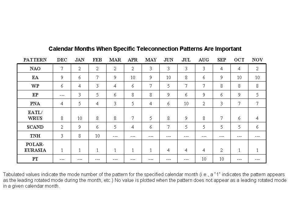
[h=2]East Atlantic/West Russia (EATL/WRUS)

teletab.gif


The East Atlantic/ West Russia (EATL/WRUS) pattern is one of two prominent that affects Eurasia during most of the year. [HIGHLIGHT] This pattern is prominent in all months except June-August, and has been referred to as the Eurasia-2 pattern by Barnston and Livezey (1987)[/HIGHLIGHT]. In Winter, two main anomaly centers, located over the Caspian Sea and western Europe, comprise the East Atlantic/ West Russia pattern.


A three-celled pattern is then evident in the spring and fall seasons, with two main anomaly centers of opposite sign located over western/ north-western Russia and over northwestern Europe.

The third center, having same sign as the Russia center, is located off the Portuguese coast in spring, but exhibits a pronounced retrogression toward Newfoundland in the fall.

The most pronounced and persistent negative phases of the East Atlantic/ West Russia pattern tend to occur in winter and early spring, with particularly large negative phases noted during the winters and early springs of 1969/70, 1976/77 and 1978/79.

Pronounced[HIGHLIGHT] positive phases [/HIGHLIGHT]of the pattern [HIGHLIGHT]are less common[/HIGHLIGHT], with the most prominent positive phase evident during late winter/ early spring of 1992/93.

[HIGHLIGHT]During this 1992/93 winter, negative height anomalies were observed throughout western and southwestern Russia, and positive height anomalies were observed throughout Europe and the eastern North Atlantic. [/HIGHLIGHT]

These conditions were accompanied by warmer and wetter than normal conditions over large portions of Scandinavia and northwestern Russia, and by much colder and drier than normal conditions over the eastern Mediterranean Sea and the Middle East.

[HIGHLIGHT]During MAM 1993, the area of negative anomalies over western Russia persisted[/HIGHLIGHT], the positive anomaly center over northwestern Europe became consolidated, and a negative anomaly center became established over the eastern North Atlantic. These conditions brought a continuation of warmer (colder) than normal conditions to Scandinavia (eastern Mediterranean Sea sector), and drier than normal conditions to much of Europe.


eawrussmap.gif


Amir Mohsen

متخصص بخش هواشناسی
این شاخص شرق آتلانتیک غرب روسیه نقش بسیار مهم و کلیدی در اقلیم ایران ایفا میکنه!!!!!!!!!
 

Amir Mohsen

متخصص بخش هواشناسی
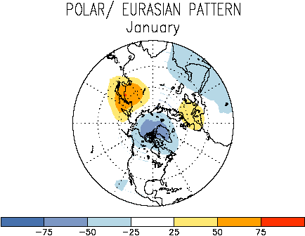
شاخص polar Eurasia تاثیراتش واقعا درجه 1 در اقلیم ایران هست:


این دقیقا توضیح میده که چرا زمستانهای دهه 1960 و 1970 اینقدر سرد و پر بارش بوده اند. برای ایران بررسی این شاخص و شاخص پست قبلی که شاخصی زمستانه هستند بسیار بسیار مهم بنظر میرسه:

[HIGHLIGHT]
The Polar/ Eurasian pattern appears only in the winter[/HIGHLIGHT], and is the most prominent mode of low-frequency variability during December and February.


The pattern consists of one [HIGHLIGHT]main anomaly center over the polar region[/HIGHLIGHT], and [HIGHLIGHT]separate centers of opposite sign to the polar anomaly over Europe and northeastern China[/HIGHLIGHT].

Thus, the pattern reflects major changes in the strength of the circumpolar circulation, and reveals the accompanying systematic changes which occur in the midlatitude circulation over large portions of Europe and Asia.

[HIGHLIGHT]
The polar/Eurasian pattern[/HIGHLIGHT] exhibits strong intradecadal and interdecadal variability, with several consecutive winters of a positive phase of the pattern often followed by several winters having a negative phase of the pattern. For example, the winters from 1964/65 through 1969/70 were dominated by a negative phase of the pattern, followed by a five-year period from 1971/72 through 1975/76 dominated by a positive phase of the pattern.

A negative phase then returned for much of the decade between 1976/77 and 1985/86, followed by a prolonged positive phase of the pattern from 1988/89 through 1992/93.

[HIGHLIGHT]These prolonged positive phases of the pattern reflected below-normal heights throughout the polar region and an enhanced circumpolar vortex, in combination with above-normal heights over much of Europe and eastern Asia.[/HIGHLIGHT]

In contrast, the prolonged negative phases of the pattern reflected above-normal heights throughout the polar region and a weaker than normal polar vortex, in combination with below-normal heights over much of Europe and eastern Asia.


poleurmap.gif

 
وضعیت
موضوع بسته شده است.
بالا