• توجه: در صورتی که از کاربران قدیمی ایران انجمن هستید و امکان ورود به سایت را ندارید، میتوانید با آیدی altin_admin@ در تلگرام تماس حاصل نمایید.

مباحث عمومی هواشناسی تابستان 1393

وضعیت
موضوع بسته شده است.

Amir Mohsen

متخصص بخش هواشناسی
آپدیت جدید هواشناسی کانادا:

7yb1e6wc4dlna7gp0nx.jpg
 

سیبری

کاربر ويژه
امروز هفتم شهریور ماه 93 ، 29آگوست 2014 مصادف است با سومین سالگرد بارش سنگین برف توچال و باران پاییزی پایتخت در شهریور رویایی 90
 

سیبری

کاربر ويژه
امروز هفتم شهریور ماه 93 ، 29آگوست 2014 مصادف است با سومین سالگرد بارش سنگین برف توچال و باران پاییزی پایتخت در شهریور رویایی 90

یاد ونامش گرامی


1 Anzali (Iran)100.0 mm
2 Rasht (Iran)53.0 mm
3 Ramsar (Iran)25.0 mm
4 Noshahr (Iran)15.2 mm
5 Semnan (Iran)12.1 mm
6 Tehran-Mehrabad (Iran)11.0 mm
7 Ghazvin (Iran)5.0 mm
8 Orumieh (Iran)4.0 mm
9 Zanjan (Iran)4.0 mm
10 Babulsar (Iran)2.9 mm
11 Kerman (Iran)2.1 mm
12 Iranshahr (Iran)2.0 mm
13 Sarab (Iran)2.0 mm
14 Maragheh (Iran)1.0 mm
24 hours amount precipitation. 08/29/2011 at 00:00 UTC
(67 of 67 stations)
 

Amir Mohsen

متخصص بخش هواشناسی
غالب مدلهای هواشناسی برای روزهای آینده وقوع آنومالی بارش با انحراف معیار بیش از 400 درصد افزایش برای بخشهایی از استانهای گلستان- شرق مازندران و برخی نقاط خراسان شمالی رو نشون میدن!

qap74j47zm5odlsc7s.jpg


خوب حالا علت چیست؟

مطابق با تصویر زیر سرانجام بلاکینگ عرضهای بالای جغرافیایی در حال تغییر هست و بنظر میرسه با مثبت شدن نوسان قطبی و همچنین منفی شدن شاخص PNA سرانجام اواخر تابستان 1393 داره به نیمه شمالی روی خوبش رو نشون میده !

rqs8d81gdct9qzqhywr.png
 

Amir Mohsen

متخصص بخش هواشناسی
دیشب رفته بودیم انتهای جاغرق و باور کنید شومینه زیر بعضی از تخت ها روشن بود !!!!!!!!!!!!!!!!!!!!!!!!!!!!! و ما هم که با لباس تابستانونی رفته بودیم از سرما می لرزیدیم!
 

سیبری

کاربر ويژه
پاییز90 از هفته اول شهریور رسما کلید خورد
زمستان 90 از نیمه آبان رسما کلید خورد

آغاز پاییز و زمستان 93 کی خواهد بود؟
 

Amir Mohsen

متخصص بخش هواشناسی
نظاره این الگو ها در نقشه ها ( غلبه تدریجی جریانات خنک و مرطوب شمالی) آدم رو شادمان میکنه:

4dz6pricfcn6lqpnklez.jpg


7ieloqqusygxutmgyv.jpg


cftxhbdryf6cfkvhcf.png
 

سیبری

کاربر ويژه
بلاشک قوچان یگانه شهر در سراسر فلات ایران است که هر رهگذر و مسافری رو مجاب میکنه در شامگاهان آغازین روزهای شهریور 93 لباس گرم بپوشند وکاپشن و جاکت بر تن نمایند
به امید خدا امشب از این صحنه های غرور آفرین عکس گرفته و در تاریخ به ثبت خواهم رسوند
وقتی ازسرمای شبانگاهی شهریور قوچان صحبت میشه فقط به دمای 7 یا 8 قوچان فکر نکنید بلکه سوز شرقی و بادهای مداوم شمالی روهم در اذهانتون به سرمای قوچان ضمیمه کنید
 

سیبری

کاربر ويژه
تابستون در قوچان مرده
آفتاب دیگه زوری نداره
گرما دیگه از کوی و برزن قوچان رخت بربسته
دشت قوچان داره آماده پاییز وزمستون میشه و این بهترین احساسه
امیدوارم آبی آسمان قوچان امسال به آبی سیبری بیشتر گره بخوره


2l7qonfg9gw8qldd48o.jpg
 

سیبری

کاربر ويژه
دیروز فهمیدم که من تنها نیستم!واز این بابت بی نهایت خوشحالم
دیروز فهمیدم که من در عشق به قوچان و سرمای اون تنها نیستم
دیروز فهمیدم که آب وهوای قوچان فقط برای من حقیر جالب نیست
دیروز فهمیدم که اولین چیزی که در ذهن هر تازه واردی ازقوچان به یاد می مونه سرمای اونه و این برای من خیلی لذت بخشه

قوچانی
|
ir.gif

|
19:51 - 1391/10/16
l_c_info.gif

52
184
پاسخ
comments.gif
شما که تیتر میزنی سرمای وحشتناک یه سر قوچان بیا شب ها دمای هوا 35 درجه زیر صفره بیشتر زمستان سردترین شب ایرانه که شما یه خبر ازش نمیزنید
مشاهده نظرات
نیمـــــــــــــــکت
مشاهده نظرات کی میگه قوچان سرده ؟؟!!
باشگاه مهندسین شیمی قوچان - بـــــــــــــــــــرزخ 3
 

سیبری

کاربر ويژه
البته نفس تابستون در مشهد کبیر هم دیگه به شماره افتاده و این روزها زائران از هوای خنک مشهد نسبت به شهرای خودشون حسابی متعجب و انگشت گزانند

مشهد چند روز پیش

xiwlw62w6ro1pp7l5fh.jpg
 

Amir Mohsen

متخصص بخش هواشناسی
[h=2]Climate study explores link between El Niño, the polar vortex and extreme cold outbreaks in Europe Posted on August 28, 2014 by Bob Berwyn
Cold snaps more likely during El Niño winters
How does El Niño affect weather in Europe?

Staff Report
FRISCO —El Niños don’t just affect anchovy fishermen in Peru and the ski resorts of the Sierra Nevada. The somewhat cyclical variation in equatorial Pacific sea surface temps can shift weather patterns worldwide, including in Europe, which may be more susceptible to extreme cold outbreaks in El Niño years, according to a new study led by a University of Colorado, Boulder researcher.
Other research has hinted at the connection, but the new paper is the first to show that El Niños might be linked with Sudden Stratospheric Warming events, when temperatures high in the atmosphere change radically, affect the polar vortex, a belt of winds that form a boundary between the cold Arctic and the temperate mid-latitudes. Sudden Stratospheric Warming weakens those winds, often leading to outbreaks of bitter cold Arctic air across Europe and possibly the eastern U.S.
Although it’s still not clear exactly how El Niño may influence the SSW events, the researchers said El Niño conditions could help forecasters know when to look for an Arctic blast.
When an El Niño event arrives every few years, it shifts the location of warm sea-surface temperatures and persistent showers and thunderstorms eastward across the tropical Pacific Ocean. The rising air forces rearrangements nearby, and the signals reverberate outward through the troposphere (the lowest few miles of the atmosphere).
Depending on location, this shifts the seasonal odds toward warm, cool, wet, or dry in many parts of the Americas, Asia, and Australia. The status of the El Niño–Southern Oscillation (ENSO) is one of the main tools used by U.S. seasonal forecasters in looking ahead to what a given winter might bring.
The new study, led by Amy Butler (University of Colorado Boulder/CIRES, is published in Environmental Research Letters, finds clear evidence for the link over the last half-century.
“Ours is the first study to examine the observations and really pull apart how El Niño can bring impacts all the way to the other side of the world,” said coauthor Clara Deser (with the National Center for Atmospheric Research. “It’s an interesting story, separating these stratospheric and tropospheric pathways.”
The combination of an El Niño event and an SSW appears to be especially conducive to outbreaks of Arctic air. Looking at the period November through March, the scientists found that seasonal temperatures across northern Eurasia plunged more than twice as far below average during an El Nino winter with at least one SSW as compared to an El Nino winter with no SSWs.
Looking at the period 1958–2013, the scientists also found that SSWs were more than twice as likely to occur during El Niño years as during neutral years.
“When you focus on those years, the stratospheric pathway emerges with great clarity,” said Butler.
SSWs can’t be predicted more than a few days in advance, and it’s not yet clear exactly how they form and how the influence of El Niño makes their way through the stratosphere. However, the new work suggests that forecasters could use the presence of El Niño to alert people that an SSW’s cold-inducing effects could be stronger than usual in northern Eurasia (and perhaps in eastern North America, although the current study doesn’t examine that problem directly).
According to Deser, “We can’t predict whether the sudden stratospheric warmings are going to occur, but we can say: If they do, this is what to expect.”
 

سیبری

کاربر ويژه
متاسفانه هواشناسی کشور در اقدامی غیر قابل توجیه فقط آمار مراکز استانها روتو بولتن روزانش قرار داده وایستگاه های دیگه رو حذف کرده
 

Amir Mohsen

متخصص بخش هواشناسی
علت اصلی وقوع ناهنجاری بارشی در جنوب شرق کشور برای روز های اولیه ماه سپتامبر:

iqhvd1s3xs06k3thhz3.png
 

Amir Mohsen

متخصص بخش هواشناسی
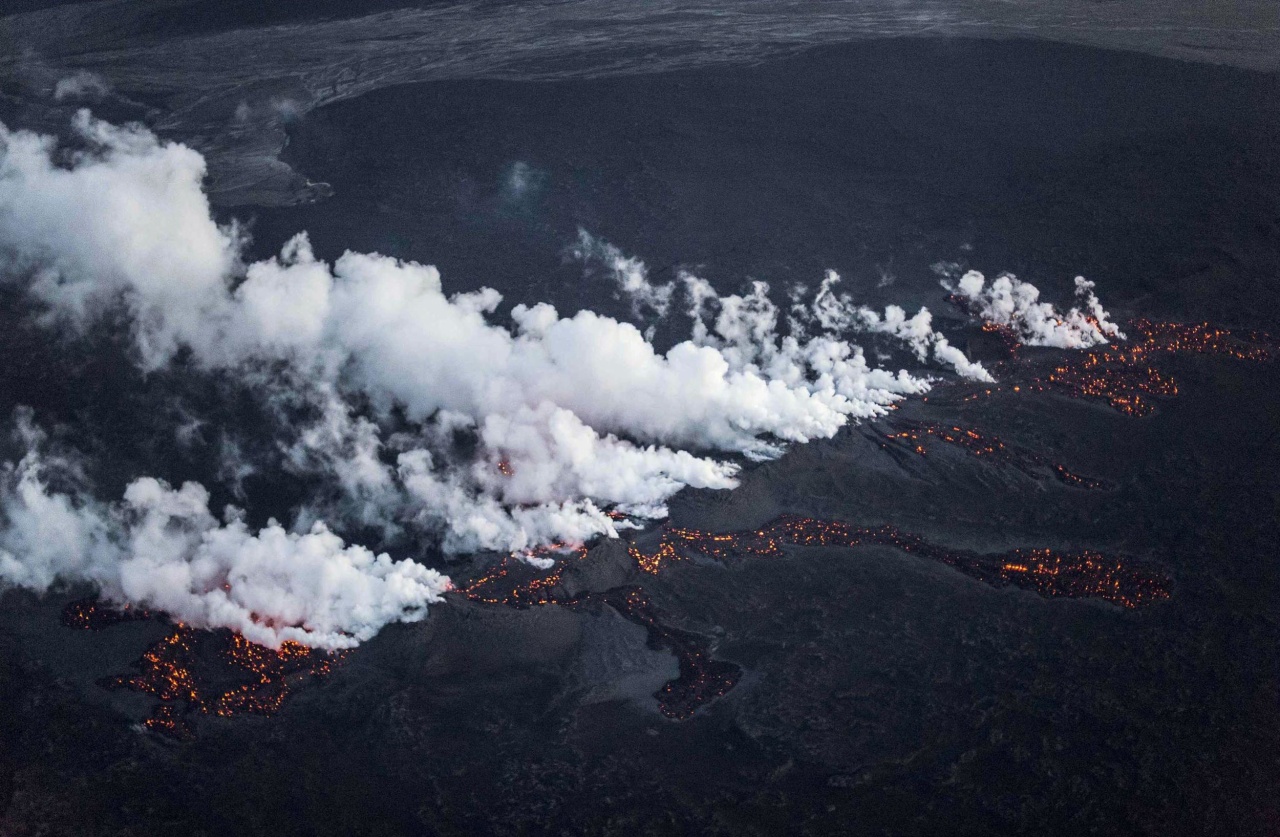
pc-140929-iceland-volcano-mn-1025_e994549174b9fc3bb20a5ac9629c001e.nbcnews-ux-1280-900.jpg

Marco Nescher / Reuters
3 hours


Iceland Volcano Erupts Along a Half-Mile Fissure
Magma flowed along a half-mile fissure Friday in a lava field north of the Vatnajokull glacier, which covers part of Iceland's Bardarbunga volcano system. Iceland raised its alert warning level to maximum on Friday after what it called a small eruption but said there was no sign of ash that could affect air travel in Europe.
 
وضعیت
موضوع بسته شده است.
بالا