-
توجه: در صورتی که از کاربران قدیمی ایران انجمن هستید و امکان ورود به سایت را ندارید، میتوانید با آیدی altin_admin@ در تلگرام تماس حاصل نمایید.
You are using an out of date browser. It may not display this or other websites correctly.
You should upgrade or use an alternative browser.
You should upgrade or use an alternative browser.
مباحث عمومی هواشناسی- خرداد ماه 1393
- شروع کننده موضوع heaven1
- تاریخ شروع
- وضعیت
- موضوع بسته شده است.
Amir Mohsen
متخصص بخش هواشناسی
2014 June Quick Look[h=3]Published: June 19, 2014A monthly summary of the status of El Niño, La Niña, and the Southern Oscillation, or ENSO, based on the NINO3.4 index (120-170W, 5S-5N)Use the navigation menu to navigate to the different forecast sectionsDuring May through mid-June the observed ENSO conditions remained near the borderline of a weak El Niño condition in the ocean, but the atmosphere so far has shown little involvement. Most of the ENSO prediction models indicate more warming coming in the months ahead, leading to sustained El Niño conditions by the middle of northern summer.
[h=3]Historically Speaking
-
Figure 1
[*]Figure 3
[*]Figure 2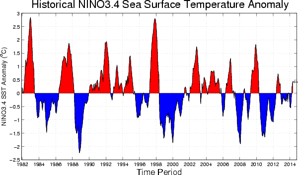
[*]Figure 4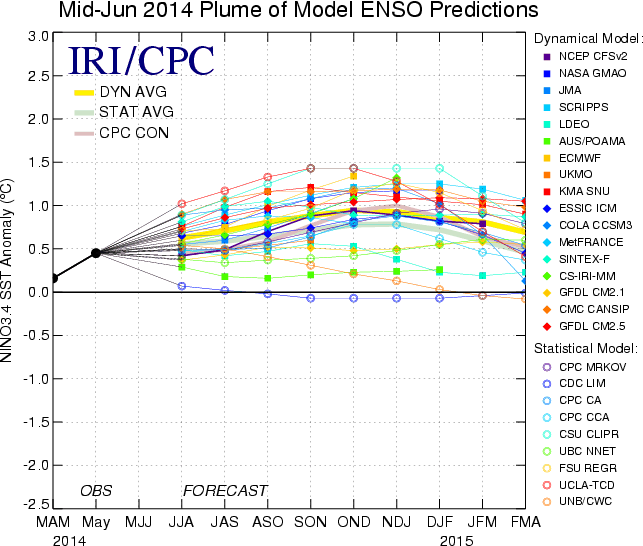
[h=3]Historically Speaking
- El Niño and La Niña events tend to develop during the period Apr-Jun and they
- Tend to reach their maximum strength during Dec-Feb
- Typically persist for 9-12 months, though occasionally persisting for up to 2 years
- Typically recur every 2 to 7 years
Amir Mohsen
متخصص بخش هواشناسی
No direct correlation between El Nino and Indian droughts: StudyJune 20, 2014 12:40 pm
http://indianexpress.com/article/bu...on-between-el-nino-and-indian-droughts-study/
http://indianexpress.com/article/bu...on-between-el-nino-and-indian-droughts-study/
Amir Mohsen
متخصص بخش هواشناسی
|
[TR]
[TD="class: blog_title, align: left"]El Nino By A Different Name Maybe[/TD]
[/TR]
[TR]
[TD="class: blog_content"]
There's been a great deal of discussion about the Pacific Ocean trends during the year 2014. Back in February, there were forecasts of an El Nino to form that would rival the super El Nino of the late 1990s. Jump ahead to mid-June, and while the is indeed some El Nino-related influence on weather patterns, the actual ocean conditions are not matching up quite as well. The biggest holdout, as many of you know, is the barometric feature known as the Southern Oscillation Index (SOI); this feature has stalled out in a neutral category.
(NOAA)
What is going on to keep the SOI from joining ranks, so to speak, toward the El Nino objective? There's not a definitive answer at this time, other than to say that the circulation pattern in the tropical Pacific has not gone into a prevailing west-to-east tendency. Certainly the water temperature is at El Nino levels; data kept for the eastern Pacific by my colleague Mike Palmerino show that the eastern Pacific region has a temperature trend of +1.5 deg Celsius above normal. That temperature level is in a moderate category for El Nino on temperatures.There is some question as to whether this event will become a hybrid type of El Nino--an entity known as "El Nino Modoki". (pronounced MOE-doe-kye) This type of El Nino definition is fairly new; first recorded in 1986. The name "Modoki" is Japanese for "similar, but different".In an El Nino Modoki, the Pacific water temperature pattern features a large pool of warm water in the central part of the ocean, with cooler conditions on both sides--South America on the east, and the Asian archipelago on the west. An El Nino Modoki is associated with some different trends than a typical El Nino--the most dramatic one being that, in an El Nino Modoki, hurricane threats to the U.S. mainland are greater than in a typical eastern Pacific-focused El Nino. As of this blog posting on Friday, June 20, 2014, I was not able to identify any definite impact references to agriculture in the U.S., South America, Australia, or Asia.
[HIGHLIGHT]
Is it possible that an El Nino Modoki is in the very early stages of forming? Yes, very tentatively.
[/HIGHLIGHT]
The Pacific temperatures right now are warm across the entire equator region, with the warmest values relative to normal just off the South America coast near Ecuador-Peru. So, right now, those water temperatures are not in an El Nino Modoki category. However, not too far to the south, there is a good-sized area of the ocean where the water temperature is running around one-half degree Celsius below normal. [HIGHLIGHT]This pool is not too far from the island of Tahiti, where one of the barometers for computing the SOI is stationed--so, perhaps this is why the SOI has been hovering near neutral. And, if the cooler-temperature pool expands northward, there could indeed be an El Nino Modoki forming--possibly.[/HIGHLIGHT]
I'm going to do more looking into the El Nino Modoki topic, particularly regarding its potential agricultural effects. I am especially curious as to the relationship to precipitation in the western and southern U.S., drought in Australia, and the performance of the India monsoon. We have seen indications of a traditional El Nino-related effect in some of these areas already; whether a developing El Nino Modoki would change that or not is definitely worth more study.
I'm going to do more looking into the El Nino Modoki topic, particularly regarding its potential agricultural effects. I am especially curious as to the relationship to precipitation in the western and southern U.S., drought in Australia, and the performance of the India monsoon. We have seen indications of a traditional El Nino-related effect in some of these areas already; whether a developing El Nino Modoki would change that or not is definitely worth more study.
[/TD]
[/TR]
Amir Mohsen
متخصص بخش هواشناسی
Amir Mohsen
متخصص بخش هواشناسی
Amir Mohsen
متخصص بخش هواشناسی
June 2014 Climate Briefing: El Niño Likely to Develop this Summer Posted by Justin Grieser on June 20, 2014
From the June climate briefing, given by IRI’s Chief Forecaster Tony Barnston:
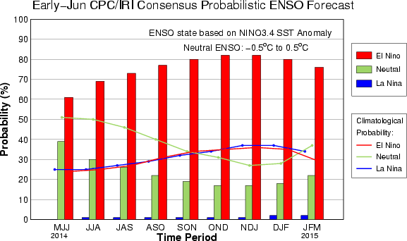
[h=3]Tony Barnston provides an overview of the briefing [h=3]Changes from last month’s briefing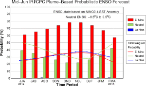 The IRI/CPC probabilistic ENSO forecast issued mid-June 2014. Note that bars indicate likelihood of El Niño occurring, not its potential strength. Unlike the official ENSO forecast issued at the beginning of each month, IRI and CPC issue this updated forecast based solely on model outputs. The official forecast, available at http://1.usa.gov/1j9gA8b, incorporates human judgement.
As the northern hemisphere summer gets underway, the El Niño Southern Oscillation (ENSO) shows signs of borderline neutral/weak El Niño conditions in the equatorial Pacific. However, conditions in the atmosphere remain ENSO-neutral. The Niño3.4 sea-surface temperature anomaly was +0.4ºC last week, just shy of the +0.5ºC threshold indicative of El Niño conditions and 0.1ºC lower than the anomaly seen in early May.
The IRI’s June ENSO forecast predicts a 60% chance of El Niño developing during the current June-August season, and a 75-80% chance by mid-autumn. These probabilities are a slight increase from the IRI’s May forecast, but marginally lower than NOAA/IRI’s forecast issued June 5.
The main reason these probabilities have not increased is the lack of atmospheric involvement in response to the ocean and in further nudging the ocean toward an El Niño state. Sea surface temperature anomalies are strongly positive in the eastern Pacific, which has already caused El Niño-like weather impacts along the coast of Peru. However, the Niño3.4 anomalies remain closer to normal compared to the warmer western and eastern portions of the Pacific basin.
The lack of a gradient in sea surface temperature anomalies is discouraging development of steadier wind flow from Indonesia from pushing the warm waters of the western Pacific eastward, which would be expected during developing El Niño conditions.
Although the atmosphere is lagging behind the El Niño-like sea surface temperature pattern, Chief IRI Forecaster Tony Barnston expects a stronger atmospheric response in the next one to three months. “Many El Niño events develop this way, where the atmosphere takes longer than the ocean to play ball,” he said.
While the likelihood of an El Niño developing by mid-autumn has increased, model forecasts are still uncertain about the strength of the event. Most models are predicting a moderate El Niño, with a slightly greater chance of a weak event than a strong one.
[h=3]Effects of El Niño on global seasonal climate forecasts [h=4]There’s a strong tilt of the odds toward low precipitation in Indonesia and northern South America…During the northern hemisphere autumn, above-normal rainfall is likely in southeastern South America and the greater Horn of Africa. Each month, IRI issues seasonal climate forecasts for the entire globe. These forecasts, which take into account the latest ENSO projections, indicate which areas are more likely to see above or below normal temperatures and rainfall. The latest forecasts show a moderate to high climate impact in areas most directly affected by ENSO events.
For the upcoming July-September season, Barnston noted there is a “strong tilt of the odds toward low precipitation in Indonesia and northern South America” compared with IRI’s May forecast. During the northern hemisphere autumn, above-normal rainfall is likely in southeastern South America and the greater Horn of Africa.
Scientists should know more each month about the chances for El Niño, its potential strength, and the climate impacts. Sign up here to get notified when the next forecast is issued, and in the meantime, check out #IRIforecast or use #ENSOQandA on Twitter to ask your El Niño questions. Our ENSO page has background information on links to our current forecasts.
http://iri.columbia.edu/news/june-2...riefing-el-nino-likely-to-develop-this-summer
From the June climate briefing, given by IRI’s Chief Forecaster Tony Barnston:
[h=3]Tony Barnston provides an overview of the briefing [h=3]Changes from last month’s briefing
 The IRI/CPC probabilistic ENSO forecast issued mid-June 2014. Note that bars indicate likelihood of El Niño occurring, not its potential strength. Unlike the official ENSO forecast issued at the beginning of each month, IRI and CPC issue this updated forecast based solely on model outputs. The official forecast, available at http://1.usa.gov/1j9gA8b, incorporates human judgement.
As the northern hemisphere summer gets underway, the El Niño Southern Oscillation (ENSO) shows signs of borderline neutral/weak El Niño conditions in the equatorial Pacific. However, conditions in the atmosphere remain ENSO-neutral. The Niño3.4 sea-surface temperature anomaly was +0.4ºC last week, just shy of the +0.5ºC threshold indicative of El Niño conditions and 0.1ºC lower than the anomaly seen in early May.
The IRI’s June ENSO forecast predicts a 60% chance of El Niño developing during the current June-August season, and a 75-80% chance by mid-autumn. These probabilities are a slight increase from the IRI’s May forecast, but marginally lower than NOAA/IRI’s forecast issued June 5.
The main reason these probabilities have not increased is the lack of atmospheric involvement in response to the ocean and in further nudging the ocean toward an El Niño state. Sea surface temperature anomalies are strongly positive in the eastern Pacific, which has already caused El Niño-like weather impacts along the coast of Peru. However, the Niño3.4 anomalies remain closer to normal compared to the warmer western and eastern portions of the Pacific basin.
The lack of a gradient in sea surface temperature anomalies is discouraging development of steadier wind flow from Indonesia from pushing the warm waters of the western Pacific eastward, which would be expected during developing El Niño conditions.
Although the atmosphere is lagging behind the El Niño-like sea surface temperature pattern, Chief IRI Forecaster Tony Barnston expects a stronger atmospheric response in the next one to three months. “Many El Niño events develop this way, where the atmosphere takes longer than the ocean to play ball,” he said.
While the likelihood of an El Niño developing by mid-autumn has increased, model forecasts are still uncertain about the strength of the event. Most models are predicting a moderate El Niño, with a slightly greater chance of a weak event than a strong one.
[h=3]Effects of El Niño on global seasonal climate forecasts [h=4]There’s a strong tilt of the odds toward low precipitation in Indonesia and northern South America…During the northern hemisphere autumn, above-normal rainfall is likely in southeastern South America and the greater Horn of Africa. Each month, IRI issues seasonal climate forecasts for the entire globe. These forecasts, which take into account the latest ENSO projections, indicate which areas are more likely to see above or below normal temperatures and rainfall. The latest forecasts show a moderate to high climate impact in areas most directly affected by ENSO events.
For the upcoming July-September season, Barnston noted there is a “strong tilt of the odds toward low precipitation in Indonesia and northern South America” compared with IRI’s May forecast. During the northern hemisphere autumn, above-normal rainfall is likely in southeastern South America and the greater Horn of Africa.
Scientists should know more each month about the chances for El Niño, its potential strength, and the climate impacts. Sign up here to get notified when the next forecast is issued, and in the meantime, check out #IRIforecast or use #ENSOQandA on Twitter to ask your El Niño questions. Our ENSO page has background information on links to our current forecasts.
http://iri.columbia.edu/news/june-2...riefing-el-nino-likely-to-develop-this-summer
Amir Mohsen
متخصص بخش هواشناسی
Looks like the atmosphere may finally start responding to this El Niño. Strength at this point remains anybody guess. Models have been slowly and steadily backing off on the strong El Niño idea.
Amir Mohsen
متخصص بخش هواشناسی
It appears the +IO anomalies are waning. Plus the negative South Pacific anomalies are weaker. This should hopefully bring us from a volatile(up and down) to a sustained -SOI.


Amir Mohsen
متخصص بخش هواشناسی
خوب داريم امروز 21 ژوئن يكي از 3 ماهه گرم مشهد رو با دماي 36 پشت سر ميذاريم. 2 ماهه گرم ديگه يعني جولاي و آگوست رو هم در ادامه پيش رو داريم. به آمار دمايي مشهد كه نگاه ميكردم ، بدون استثنا ميانگين جولاي دو درجه بالاتر از ژوئنه و آگوست هم مشابه ماهي هست كه در اون قرار داريم.
ميانگين ژوئن: 24.4
ميانگين جولاي :26.6
ميانگين آگوست: 24.8
پس خودتونو واسه روزهاي گرم و داغ مشهد اماده كنيد.
در ضمن فردا طولاني ترين روز سال هست. و انشالله اگه خدا بخواد كم كم ديگه اين روزهاي كش دار از پس فردا كوچيك ميشن.
جالبه بودنيد كه موعد غروب خورشيد فردا 19.53 هست كه تا 14 تير بدون تغيير و در همين ساعت رخ خواهد داد( به عبارتي روز فقط از طلوع كوچك خواهد شد.)
| Sat 6/21/2014 | 35° | 23° | 0 mm | 0 CM |
| ||||
|---|---|---|---|---|---|---|---|---|---|
| Sun 6/22/2014 | 36° | 22° | 0 mm | 0 CM |
| ||||
| Mon 6/23/2014 | 36° | 21° | 0 mm | 0 CM |
| ||||
| Tue 6/24/2014 | 34° | 20° | 0 mm | 0 CM |
| ||||
| Wed 6/25/2014 | 33° | 21° | 0 mm | 0 CM |
| ||||
| Thu 6/26/2014 | 36° | 24° | 0 mm | 0 CM |
| ||||
| Fri 6/27/2014 | 38° | 24° | 0 mm | 0 CM |
| � | |||
| � |
درود بر دوستان گرامی
این تایپیک همکنون در ساعات پایانی خرداد سال 1393 بسته خواهد شد ادامه بحث مباحث عمومی هواشناسی در تایپیک زیر خواهد بود
http://www.iranjoman.com/showthread.php?t=93852
در ضمن مباحث تخصصی هواشناسی مربوط به شاخص های دور پیوندی در تایپیک زیر دنبال خواهد شد
http://www.iranjoman.com/showthread.php?t=93851
موفق باشید :احترام::احترام::احترام::احترام:
- وضعیت
- موضوع بسته شده است.

