• توجه: در صورتی که از کاربران قدیمی ایران انجمن هستید و امکان ورود به سایت را ندارید، میتوانید با آیدی altin_admin@ در تلگرام تماس حاصل نمایید.

مباحث عمومی هواشناسی

وضعیت
موضوع بسته شده است.

Amir Mohsen

متخصص بخش هواشناسی
[h=2]Heavy Rain, Snow to Blast Korean Peninsula and China
depodwin.png
[h=6]By Dan DePodwin, Meteorologist [h=5]November 24, 2013; 6:11 PM
Share |

asia.jpg

The dry stretch of weather across the Korean Peninsula and northeastern China will come to an abrupt end through Monday as a strengthening storm brings heavy rain and snow to the region.
A disturbance will raced across central China through the first half of the weekend and gained strength as it nears the Yellow Sea.
Moisture drawn northward from the Pacific Ocean and East China Sea will interact with the storm, creating a swath of heavy precipitation from the Korean Peninsula into Liaoning and Jilin provinces of China into Monday, local time.
North of the storm track, heavy snow is expected as the moisture clashes with cold, Siberian air. Over 30 cm (12 inches) of snow can fall in the mountains of North Korea and far northeastern China.
To the south, milder air should promote mainly rain for South Korea as well as the southern tip of Liaoning province, including the city of Dalian.
650x366_11221758_chinastorm.jpg

Although the storm is expected to race northeast, rain amounts between 25 and 50 mm (1-2 inches) will be common. While widespread flooding is not expected, localized rainfall amounts over 75 mm (3 inches) can lead to some flooding concerns.
In the wake of the storm, winds will become strong, gusting to 80 kph (50 mph) along the western coast of the Korean Peninsula with 50- to 65-kph (30- to 40-mph) gusts farther inland across the peninsula.
A large area of cold air is expected to dive into the region by the middle of next week. Temperatures will be near 0C in many places including as far south as Seoul, South Korea.
Farther west, Beijing will escape the heavy rain and snow, but the chilly conditions should build into the area by Wednesday.


Amir Mohsen

متخصص بخش هواشناسی
[h=2]East Coast Winter Storm to Snarl Thanksgiving Travel
pydynowski.png
[h=6]By Kristina Pydynowski, Senior Meteorologist [h=5]November 24, 2013; 4:04 PM
Share |

vbraynob.jpg
An expert analysis on the impending snow headed to the East is given in the above AccuWeather.com video.
A major winter storm will unfold across the East Coast on Wednesday, threatening to create a nightmare for the millions of Thanksgiving holiday travelers--even those elsewhere in the U.S.
The same storm bringing snow and ice to New Mexico and the southern Plains to close out the weekend is set to spread heavy rain across the South and I-95 corridor Tuesday through Wednesday.
The storm has already been blamed for the deaths of eight people across the Southwest since Thursday, according to the Associated Press.
Substantial snow will unfold from the spine of the Appalachians to the St. Lawrence Valley and far northern New England.
650x366_11241605_travel.jpg

"The potential exists for a foot of snow to fall from Bradford, Pa., to Burlington, Vt.," stated AccuWeather.com Meteorologist Eric Wanenchak.
The timing of the impending winter storm could not come at a worst time with AAA projecting 43.4 million travelers during the Thanksgiving holiday weekend.
"The Wednesday before Thanksgiving will be the busiest single day of travel with 37 percent of travelers departing for trips Nov. 27," AAA stated in a press release.
[h=3]Heavy Rain for I-95 Corridor Wednesday Heavy rain set to inundate the South on Tuesday will spread across the Carolinas and up the Northeast's I-95 corridor late Tuesday through Wednesday to Washington, D.C., Philadelphia, New York City and Boston.
Even without snow in the forecast, AccuWeather.com Expert Senior Meteorologist Alex Sosnowski stated, "[The rain] would be enough to slow travel on the highways and delay a number of flights."
RELATED:
AccuWeather.com Travel Maps
Thanksgiving Day Weather
AccuWeather.com Winter Weather Center

Water ponding on roadways heightens the danger of vehicles hydroplaning when traveling at highway speeds, while downpours threaten to dramatically reduce visibility for motorists.
650x366_11241759_eastcoast.jpg

"Gusty winds would also factor in to delays along the coast," Sosnowski continued.
Worsening the situation is the fact that the rain will be heavy enough to trigger flash flooding in some communities. Coastal flooding is another concern along the Northeast coast.
[h=3]Snow from the Appalachians to St. Lawrence Valley Current indications put the corridor from the spine of the Appalachians to the St. Lawrence Valley and far northern New England at risk for travel-disrupting snow from this midweek winter storm.
The storm will likely be an all-snow event across northwestern Pennsylvania and western New York to west of Montreal, Canada.
650x366_11241922_snowmap.jpg

The rest of the area will see both rain and snow (likely the snow at the storm's onset, when sleet is possible in some communities, and backside). The timing of the final changeover to snow will range from late Tuesday night in the southern Appalachians to Wednesday night in the St. Lawrence Valley and far northern New England.
Snow amounts will be substantial enough to clog roads and create treacherous and slippery travel. As the storm strengthens on Wednesday, gusty winds will follow suit and whip the snow around--further reducing visibility for motorists.
In addition to Bradford and Burlington, the worst of the snowstorm may center on Syracuse, Montreal and stretches of Interstates 81, 86, 88, 87, 89 and 90. The snow will total 6 to 12 inches in this zone with locally higher amounts.
East of the heaviest snow zone, there could be a changeover from rain to a few inches of snow and slick travel along the I-81 corridor from Virginia to Pennsylvania and northeastward to Albany, N.Y., and central Maine.
AccuWeather.com meteorologists do not expect snow to reach the I-95 corridor.
[h=3]Southern Rain, Thunderstorms, Wind Rain and thunderstorms developing along the western Gulf Coast on Monday will spread eastward across the Deep South Monday night and to the Southeast and southern mid-Atlantic on Tuesday.
Travel delays on the I-10 and I-20 corridors are in store from Louisiana to Mississippi, Alabama, Georgia, South Carolina and northern Florida from rain-soaked highways and poor visibility from downpours.
The soaking rain and low-hanging clouds could delay flights at New Orleans, Atlanta, Charlotte and other airports in the region for travelers heading to their Thanksgiving destinations early.
Across southern Georgia and Florida, there is concern for the thunderstorms to turn severe Tuesday through Tuesday night.
As the worst of the storm shifts to the Northeast, more travel problems may unfold in the South on Wednesday due to lingering rain, wind and gusty winds.
[h=3]Rest of the Nation Much of the rest of the nation will have good travel conditions.
650x366_11241552_hd14.jpg

Beware, aircraft and flight crews originating from the South and Northeast could be delayed, perhaps causing ripple-effect problems with a few flights throughout the nation.
There will be bands of lake-effect snow over the Upper Midwest, due to fresh cold air moving in Tuesday and Wednesday. The lake-effect snow will gradually wind down in many locations on Thanksgiving Day.
While odds favor the snow streaming over areas south to southeast of the lakes, there is some concern lake-effect snow will sneak into Chicago and cause issues at O'Hare International Airport on Wednesday.
AccuWeather.com Expert Senior Meteorologist Alex Sosnowski contributed to the content of this story.


Miss zahra

متخصص بخش تکنولوژی
عی بابااااااااااا...چرا mrs زدی پس آبجی! فکر کردم بسلامتی خبری شده :خجالت2:
چه دردسری همه شیرینی می خوان نهههههههههههههههههههه :خجالت2:
پس زود عوض کنید با این شور و نشاط miss بیشتر بهتون میاد آبجی :خنده1:
ایشالا دفعه بعد خبر بهتری براتون داشته باشیم...این هفته که گرمم میشه..اگه پتانسیل آلودگی دارین آلوده هم میشه...ببخشید همش خبر بد گرفتین :ناراحت:

اشتباهی زدم دیگه:122:
سلامی دوباره:54:
چشم عوض میکنم:فرار:
ایشالا:دعا: اشکالی نداره:30: خوش خبر باشید:giggle::5:
1448387109.gif

چه خوبه:8:
 

Amir Mohsen

متخصص بخش هواشناسی
ao-nao_pos_vs_neg_0.jpg


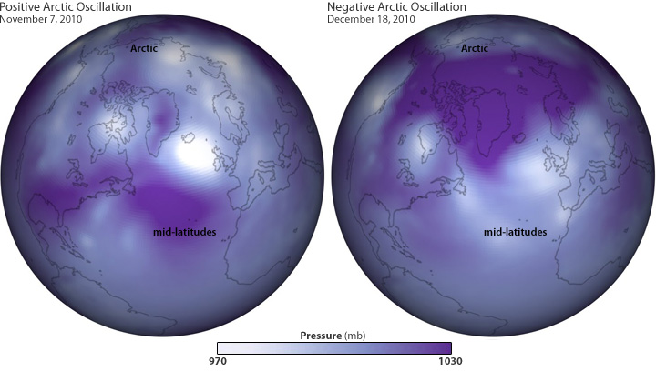
These maps show air pressure patterns on November 7, 2010 (left), when the Arctic Oscillation was strongly positive, and on December 18 (right), when it was strongly negative. These phases are the result of the whole atmosphere periodically shifting its weight back and forth between the Arctic and the mid-latitudes of the Atlantic and Pacific Ocean, like water sloshing back and forth in a bowl. (Maps by Ned Gardiner and Hunter Allen, based on Global Forecast System data from the National Centers for Environmental Prediction.) Large images: November 7 | December 18
 

Amir Mohsen

متخصص بخش هواشناسی
ao-nao2_pos_vs_neg_0.jpg


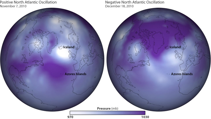
Air pressure on Nov. 7 (left) and Dec. 18, 2010. Same as the maps above, but labelled with features relevant to the North Atlantic Oscillation (NAO). The NAO is usually in phase with the Arctic Oscillation (AO)—both positive, or both negative—but their intensity may be different. On these dates, the AO was strongly positive on Nov. 7 and strongly negative on Dec. 18; the NAO was also strongly positive on Nov. 7, but only weakly negative on Dec. 18. Based on Global Forecast System data from the National Centers for Environmental Prediction.
It’s no coincidence that the regional-scale air pressure patterns linked to the North Atlantic Oscillation are visible in the same maps used to illustrate the Arctic Oscillation. The similarity makes sense: many meteorologists consider the North Atlantic Oscillation to be a “regional subset” of the Arctic Oscillation, which operates across the whole Northern Hemisphere.

End_Symbol_465_0.gif
Do you have feedback to offer on this or another article?
Let us know what you think.


Amir Mohsen

متخصص بخش هواشناسی
مجموع رخ داد بارش در نوامبر و دسامبر سال 2010

85696800154779126149.jpg


32446288843188104035.jpg


نتیجه:

با توجه به نقشه های شاخصهای nao و ao در فاز های مثبت و منفی در نوامبر و دسامبر سال 2010 و تطابق مجموع رخ داد بارش در ماههای نوامبر و دسامبر سال مذکور بر اساس مدل WRF ، اطلاق تاثیر پذیری اقلیم کل کشور از این شاخصها کاملا مردود میباشد و وقوع هر دو فاز مثبت و منفی شاخصهای مذکور تنها به رخ داد فراوانی درصد بارش در بخشهای محدودی از ایران میگردد.

صادقانه بگم که این شاخصها تنها بر اقلیم 10 درصد از ایران در مقوله بارش تاثیر گذار هستند!
 

هادی...

New member
در حالی که هیچ سایت ونقشه ای برای امروز بارش پیش بینی نکرده بود،هم اکنون درشاهین دژ شاهد رگبار نسبتا شدیدباران هستیم،این ابر خیلی زودرشد کرده وموجب رگبار شده،امیدوارم ایستگاه روهم این رگبار بگیره
 

DR WHO

کاربر ويژه
نتيجه گيرى :

خدا رو شكر كه پاييز امسال مثل پاييز ١٣٨٩ نشد

و

اينكه نميشه گفت AO مثبت بهتره يا AO منفى

بستگى به وضعيت ديگر شاخص ها داره

و اينطور كه به نظر مياد نوسان قطب شمال به اونصورت تاثير خاصى بر دما و بارش كشور نداره اما با اين حال بايد وضعيت ديگر نوسانات را هم ديد بعد ميشه گفت الان فاز مثبت مفيد هست يا منفى

استاد بى خيال اين نوسانات

نيمه دوم را درياب كه خبر آمد خبرى در راه است ...
 

arashz

مدیر بخش هواشناسی
ao-nao2_pos_vs_neg_0.jpg


Air pressure on Nov. 7 (left) and Dec. 18, 2010. Same as the maps above, but labelled with features relevant to the North Atlantic Oscillation (NAO). The NAO is usually in phase with the Arctic Oscillation (AO)—both positive, or both negative—but their intensity may be different. On these dates, the AO was strongly positive on Nov. 7 and strongly negative on Dec. 18; the NAO was also strongly positive on Nov. 7, but only weakly negative on Dec. 18. Based on Global Forecast System data from the National Centers for Environmental Prediction.
It’s no coincidence that the regional-scale air pressure patterns linked to the North Atlantic Oscillation are visible in the same maps used to illustrate the Arctic Oscillation. The similarity makes sense: many meteorologists consider the North Atlantic Oscillation to be a “regional subset” of the Arctic Oscillation, which operates across the whole Northern Hemisphere.

End_Symbol_465_0.gif
Do you have feedback to offer on this or another article?
Let us know what you think.


درود دوستان

این مولفه چه مثبت باشه چه منفی منطقه ما تحت تاثیر پرفشار هست، پس نباید روی این مولفه زیاد حساب کرد، همونطور که امیرمحسن عزیز گفتن شاید کمتر از 10% خاک کشور عزیز ما تحت تاثیر این مولفه باشه که به نظر باید نوار ساحلی شمالی کشور باشه.
 

alirezamousavi

New member
:mehdi:
slider_tgifsmiley.gif
explanation.gif
tribal2.gif
5yjbztv.gif
orjnfq.gif
bdayparty.gif
cauldronsmileyf.gif
shrk.gif
[FONT=tahoma, Arial, Helvetica, sans-serif][FONT=tahoma, Arial, Helvetica, sans-serif]
391219_bollywood1.gif
[FONT=tahoma, Arial, Helvetica, sans-serif][FONT=tahoma, Arial, Helvetica, sans-serif]
152017_j6332h.gif
28.gif
[FONT=tahoma, Arial, Helvetica, sans-serif][FONT=tahoma, Arial, Helvetica, sans-serif]
512019_treasuresmile3.gif
[FONT=tahoma, Arial, Helvetica, sans-serif][FONT=tahoma, Arial, Helvetica, sans-serif][FONT=tahoma, Arial, Helvetica, sans-serif]
722919_335d1dk.gif
fxsug7rwvcr2pk5nr0s.gif
:135:


:134:


:136:


:زمستان:


:پاییز:


:بهار:


:59:


:56:


:24:


:61:


:TAHEREH:


:adambarfy:
 

Amir Mohsen

متخصص بخش هواشناسی
درود امیر کوروش عزیز

کاملا با شما موافقم .

برای من همین کفایت که دیگه شما حمد و ثنای این شاخصها رو نمیکنید.

و برای آخرین مطلب در این خصوص باید عرض کنم که مطابق با نقش های مختلفی که بررسی کردم تاثیرات این شاخصها برای وضعیت دمایی کشور و ضخامت لایه 500-1000 میلی بار به شرح ذیل هست:

28926313000237225290.png


96529552467709031697.png


86917412451107094533.png


نتيجه گيرى :

خدا رو شكر كه پاييز امسال مثل پاييز ١٣٨٩ نشد

و

اينكه نميشه گفت AO مثبت بهتره يا AO منفى

بستگى به وضعيت ديگر شاخص ها داره

و اينطور كه به نظر مياد نوسان قطب شمال به اونصورت تاثير خاصى بر دما و بارش كشور نداره اما با اين حال بايد وضعيت ديگر نوسانات را هم ديد بعد ميشه گفت الان فاز مثبت مفيد هست يا منفى

استاد بى خيال اين نوسانات

نيمه دوم را درياب كه خبر آمد خبرى در راه است ...
 

Amir Mohsen

متخصص بخش هواشناسی
دیگه امیدوارم از این به بعد تفکرات سنتی و ملا لغتی در خصوص تاثیرات این شاخصها دیگه به کنار گذاشته بشه و از این پس محققان به دنبال بررسی مستدل و علمی شاخصهای تاثیر گذار بر اقلیم کشور باشند.

برای ما خراسانیها هم از این به بعد بررسی لحظه ای نوسانات PNA در معقوله تاثیرات دمایی بسیار پر اهمیت و ضروری بنظر میرسه چون فاز منفی این شاخص منجر به وقوع دمای سردتر از هنجار در منطقه ما میشه:گل:
 

aliwinter

Banned
اقای امیر محسن عزیز این مقالات علمی که قرار میدید ,ترجمه هم داشته باشه خیلی بهتر میشه
هم ما استفاده میکنیم همه شما ثوابشو میبرید!:خنده1:
هوای رشت مه آلوده دما12
 
وضعیت
موضوع بسته شده است.
بالا