-
توجه: در صورتی که از کاربران قدیمی ایران انجمن هستید و امکان ورود به سایت را ندارید، میتوانید با آیدی altin_admin@ در تلگرام تماس حاصل نمایید.
You are using an out of date browser. It may not display this or other websites correctly.
You should upgrade or use an alternative browser.
You should upgrade or use an alternative browser.
مباحث عمومی هواشناسی
- شروع کننده موضوع Amir Mohsen
- تاریخ شروع
- وضعیت
- موضوع بسته شده است.
Amir Mohsen
متخصص بخش هواشناسی
جی اف اس نسیت به آپدیت بامداد خیلی بدتر شده!
سلام
فرقی نکرده از دیشب تا حالا و ثابت مونده هادی جان:گل:
سلام
فرقی نکرده از دیشب تا حالا و ثابت مونده هادی جان:گل:
درود بر شما امير جان
ميزان بارش پيش بيني شده در مدل عددي صبح 11 ميل بود در حاليكه الان 8.7 ميل پيش بيني شده!
Amir Mohsen
متخصص بخش هواشناسی
We already know that a drought occurs when not enough rain falls to the ground. However, water vapor condenses only if air rises into the colder regions of the atmosphere. If the air doesn’t rise, then no rain will form. When there is high air pressure, air falls instead of rising. With the air pressing down in a high pressure zone, no currents of water vapor are carried upward. As a result, no condensation occurs, and little rain falls to earth. In addition, high-pressure areas push clouds and air currents downward and away, resulting in sunny, cloudless weather. Low-pressure systems see more cloudy, stormy weather.
Usually, however, we experience both high- and low-pressure systems. It is normal for a high-pressure system to pass over an area and move on, being replaced by a low-pressure system. However, when a high-pressure system is stalled, the sunny weather can drag on for days. If it keeps on going, the result is a drought.
High-pressure systems can be stalled by jet streams, wide bands of fast-moving air (up to 335 miles per hour) in the upper atmosphere. Masses of air that usually move from place to place can be locked in one area by jet streams.
Unusual currents of cold and warm water in the ocean can also stall a high-pressure system. In the Pacific, a warm water current known as El Nino brings low-pressure systems that cause hurricanes and other violent storms to North America, while a cold water current known as La Nina brings drought. In Asia, the opposite occurs, with El Nino bringing drought and La Nina stormy weather.
Or droughts occur because water vapor is not brought by air currents to the right areas at the right times. Water that evaporates from the oceans is brought inland by wind to regions where it is needed. However, sometimes those winds are not strong enough. In the eastern United States, moisture is carried up from the Gulf of Mexico by northward blowing winds. This moisture is then pushed by other winds until it reaches the Midwest. This water then falls to the ground, supporting the farms in that region. However, if the winds don’t blow at the right time, in the right direction, or with enough force, the moisture falls in other areas and that Midwest region suffers from drought. A similar phenomenon occurs in southeast Asia. Usually, summer winds known as monsoons carry water vapor north from the Indian Ocean inland, providing desperately needed rain. Sometimes, however, instead of blowing from north to south, they blow east to west. When that happens, the vapor doesn’t leave the Indian Ocean and many people suffer from the resulting droughts.
Mountains can prevent wind from blowing moisture to needed regions. As air is moving past a mountain range, it is forced to rise in order to pass over the peaks. However, as the air rises, it becomes colder and the vapor condenses into rain or snow. The rain then falls on that side of the mountain, known as the windward side (the side that is turned toward the wind). When the air mass finally makes it over the mountain, it has lost much of its vapor. This is another reason why many deserts are found on the side of a mountain facing away from the ocean. This phenomenon is known as the rain shadow effect.
Amir Mohsen
متخصص بخش هواشناسی
Amir Mohsen
متخصص بخش هواشناسی
Block (meteorology) From Wikipedia, the free encyclopedia
Jump to: navigation, search
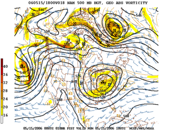

An example of an omega block over western North America in May 2006
Blocks in meteorology are large-scale patterns in the atmospheric pressure field that are nearly stationary, effectively "blocking" or redirecting migratory cyclones. They are also known as blocking highs or blocking anticyclones.[SUP][1][/SUP] These blocks can remain in place for several days or even weeks, causing the areas affected by them to have the same kind of weather for an extended period of time (e.g. precipitation for some areas, clear skies for others).[SUP][2][/SUP] In the Northern Hemisphere, extended blocking occurs most frequently in the spring over the eastern Pacific and Atlantic Oceans.[SUP][1][/SUP]
Similarly, in northern Europe anticyclonic blocks over western Russia and Scandinavia during the winter months can bring sub-zero easterly winds on their southern flanks, sometimes extending into the Atlantic Ocean and forcing the prevailing jet stream as far south as Portugal and Spain. Northern and Western European severe winters such as those of 1683–4, 1739–40, 1795, 1895, 1940, 1947, 1962–63, 1978–79, 1986, 2009–10 and December 2010 are caused by such blocks. Blocking highs were a key feature of the extreme winter droughts in southeastern Australia in 2006.[SUP][3][/SUP]
[h=2]Contents
[h=2]Impact of the polar vortex Main article: Polar cyclone
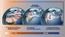

Polar vortex and weather impacts due to stratospheric warming
Polar cyclones are climatological features which hover near the poles year-round. They are weaker during summer and strongest during winter. When the polar vortex is strong, the Westerlies increase in strength. When the polar cyclone is weak, the general flow pattern across mid-latitudes buckles and significant cold outbreaks occur. Extratropical cyclones which occlude and migrate into higher latitudes create cold-core lows within the polar vortex.[SUP][4][/SUP] Volcanic eruptions in the tropics lead to a stronger polar vortex during the winter for as long as two years afterwards.[SUP][5][/SUP] The strength and position of the cyclone shapes the flow pattern across the hemisphere of its influence. An index which is used in the northern hemisphere to gage its magnitude is the Arctic oscillation.[SUP][6][/SUP]
[h=2]Omega blocks Omega blocks are so-named because the height fields with which they are associated in the Northern Hemisphere resemble an Ω, the uppercase Greek letter omega. They typically have a low-high-low pattern, arranged in the west–east direction.[SUP][2][/SUP]
[h=2]Rex blocks

An example of a rex block off the coast of North America in January 2007
Rex blocks consist of a high situated to the north (more generally, poleward) of a low. Very often both the high and the low are closed, meaning that the isobars (or constant geopotential height lines) defining the high–low close to form a circle.[SUP][7][/SUP] Rex blocks are named after the meteorologist who first identified them.[SUP][8][/SUP]
[h=2]Cut-off highs and lows See also: Cold drop
When an upper-level high- or low-pressure system becomes stuck in place due to a lack of steering currents, it is known as being "cut off". The usual pattern which leads to this is the jet stream retreating to the north, leaving the then cut-off system behind.[SUP][9][/SUP] Whether or not the system is of high- or low-pressure variety dictates the weather that the block causes. Precisely this situation occurred over the southwestern United States in late spring and early summer of 2007, when a cut-off-low system hovering over the region brought unusually cool temperatures and an extraordinary amount of rain to Texas and Oklahoma (see June 2007 Texas flooding), and a cut-off-high near the coast of Georgia that caused a drought in the Southeast that same year. If the block is a high, it will usually lead to dry, warm weather as the air beneath it is compressed and warmed; and rainy, cooler weather if the block is a low.[SUP][9][/SUP]
[h=2]Cold air damming

When warm air ahead of an oncoming storm system overrides cool air trapped east of a mountain range, cloudiness and precipitation can occur for prolonged periods of time
Main article: Cold air damming
Blocking of atmospheric systems near the surface of the Earth occurs when a well-established poleward high pressure system lies near or within the path of the advancing storm system. The thicker the cold air mass is, the more effectively it can block an invading milder air mass. The depth of the cold air mass is normally shallower than the mountain barrier which created the cold air damming, or CAD. Some events across the Intermountain West can last for ten days. Pollutants and smoke can remain suspended within the stable air mass of a cold air dam.[SUP][10][/SUP]
[h=2]See also
Jump to: navigation, search


An example of an omega block over western North America in May 2006
Blocks in meteorology are large-scale patterns in the atmospheric pressure field that are nearly stationary, effectively "blocking" or redirecting migratory cyclones. They are also known as blocking highs or blocking anticyclones.[SUP][1][/SUP] These blocks can remain in place for several days or even weeks, causing the areas affected by them to have the same kind of weather for an extended period of time (e.g. precipitation for some areas, clear skies for others).[SUP][2][/SUP] In the Northern Hemisphere, extended blocking occurs most frequently in the spring over the eastern Pacific and Atlantic Oceans.[SUP][1][/SUP]
Similarly, in northern Europe anticyclonic blocks over western Russia and Scandinavia during the winter months can bring sub-zero easterly winds on their southern flanks, sometimes extending into the Atlantic Ocean and forcing the prevailing jet stream as far south as Portugal and Spain. Northern and Western European severe winters such as those of 1683–4, 1739–40, 1795, 1895, 1940, 1947, 1962–63, 1978–79, 1986, 2009–10 and December 2010 are caused by such blocks. Blocking highs were a key feature of the extreme winter droughts in southeastern Australia in 2006.[SUP][3][/SUP]
[h=2]Contents
- 1 Impact of the polar vortex
- 2 Omega blocks
- 3 Rex blocks
- 4 Cut-off highs and lows
- 5 Cold air damming
- 6 See also
- 7 References
- 8 External links
[h=2]Impact of the polar vortex Main article: Polar cyclone


Polar vortex and weather impacts due to stratospheric warming
Polar cyclones are climatological features which hover near the poles year-round. They are weaker during summer and strongest during winter. When the polar vortex is strong, the Westerlies increase in strength. When the polar cyclone is weak, the general flow pattern across mid-latitudes buckles and significant cold outbreaks occur. Extratropical cyclones which occlude and migrate into higher latitudes create cold-core lows within the polar vortex.[SUP][4][/SUP] Volcanic eruptions in the tropics lead to a stronger polar vortex during the winter for as long as two years afterwards.[SUP][5][/SUP] The strength and position of the cyclone shapes the flow pattern across the hemisphere of its influence. An index which is used in the northern hemisphere to gage its magnitude is the Arctic oscillation.[SUP][6][/SUP]
[h=2]Omega blocks Omega blocks are so-named because the height fields with which they are associated in the Northern Hemisphere resemble an Ω, the uppercase Greek letter omega. They typically have a low-high-low pattern, arranged in the west–east direction.[SUP][2][/SUP]
[h=2]Rex blocks


An example of a rex block off the coast of North America in January 2007
Rex blocks consist of a high situated to the north (more generally, poleward) of a low. Very often both the high and the low are closed, meaning that the isobars (or constant geopotential height lines) defining the high–low close to form a circle.[SUP][7][/SUP] Rex blocks are named after the meteorologist who first identified them.[SUP][8][/SUP]
[h=2]Cut-off highs and lows See also: Cold drop
When an upper-level high- or low-pressure system becomes stuck in place due to a lack of steering currents, it is known as being "cut off". The usual pattern which leads to this is the jet stream retreating to the north, leaving the then cut-off system behind.[SUP][9][/SUP] Whether or not the system is of high- or low-pressure variety dictates the weather that the block causes. Precisely this situation occurred over the southwestern United States in late spring and early summer of 2007, when a cut-off-low system hovering over the region brought unusually cool temperatures and an extraordinary amount of rain to Texas and Oklahoma (see June 2007 Texas flooding), and a cut-off-high near the coast of Georgia that caused a drought in the Southeast that same year. If the block is a high, it will usually lead to dry, warm weather as the air beneath it is compressed and warmed; and rainy, cooler weather if the block is a low.[SUP][9][/SUP]
[h=2]Cold air damming


When warm air ahead of an oncoming storm system overrides cool air trapped east of a mountain range, cloudiness and precipitation can occur for prolonged periods of time
Main article: Cold air damming
Blocking of atmospheric systems near the surface of the Earth occurs when a well-established poleward high pressure system lies near or within the path of the advancing storm system. The thicker the cold air mass is, the more effectively it can block an invading milder air mass. The depth of the cold air mass is normally shallower than the mountain barrier which created the cold air damming, or CAD. Some events across the Intermountain West can last for ten days. Pollutants and smoke can remain suspended within the stable air mass of a cold air dam.[SUP][10][/SUP]
[h=2]See also
aliasgar57
کاربر ويژه
بارش برف ازبامداد امروز درشاهین دژ تشدیدشده ودما 1- درجست
سلام برهمه دوستان عزیز
خدارا به خاطر این رحمت های آسمانی شکرگزاریم.
با شادباش به دوستانی که در شهر محل سکونتشان بارش برف دارند ، تقا ضا میشود در صورت امکان تصاویر این لحظات زیبا را ارسال فرمایند.:گل:
سلام امیرجان
زدی تو کار آیرودینامیک و ایرفویل و هواپیما و ....:سوت:
Amir Mohsen
متخصص بخش هواشناسی
Wow
بهروز جان فریدونشهر ترکوند واقعا
هنوزم بارش برف ادامه داره آیا؟
Sent from my SM-N900 using Tapatalk
Wow
بهروز جان فریدونشهر ترکوند واقعا
هنوزم بارش برف ادامه داره آیا؟
Sent from my SM-N900 using Tapatalk
فعلا قطع شده،ولی آسمون گرفته هست،احتمال آغاز شدنش هست
خبرگزاری ایمنا: مشاور وزیر نیرو با اشاره به اینکه وضعيت كنوني زاينده رود مطلوب نيست و اكنون حجم ورودي و خروجي اين سد يكسان است، گفت: طی هفته گذشته سهم استان يزد از آب انتقالي به زايندهرود كاهش يافت و براي تامين آب شهر يزد به منابع آب زير زميني متكي شديم و اندكي افزايش شوري آب رخ داد.
شنبه ۲۳ آذر ۱۳۹۲ - ۰۹:۲۲
به گزارش ایمنا، حمیدرضا جانباز با اعلام كاهش ۱۰ درصدي مصرف آب كشور در ۶ ماه نخست امسال، اظهار داشت: با اطلاع رساني هايي كه براي كاهش مصرف آب انجام شد، مردم همكاري خوبي را در اين زمينه انجام داده اند.
وی افزود: اكنون در اصفهان چاه هاي فلمن را از دست داده ايم و كلا متكي به آب زاينده رود هستيم.
مشاور وزیر نیرو با بیان اینکه در نیمه نخست امسال بیشترین کاهش مصرف آب در تهران و اهواز بوده است، از افزایش مصرف آب در کرج و قم خبر داد و افزود: اراک تابستان سختی در پیش دارد و در استان کرمان وضعیت آب بحرانی است.
وی با بيان اينكه در نيمه نخست سال ۹۲ مصرف آب كشور حدود ۱۰ درصد در مقايسه با ۶ ماهه نخست سال ۹۱ كاهش يافته است، تصریح کرد: بيشترين كاهش مصرف در شهرهاي اهواز و تهران بوده است.
جانباز ادامه داد: متاسفانه در قم و كرج بيشترين ميزان افزايش مصرف در شش ماه نخست امسال رخ داده است كه مديريت مصرف در اين دو شهر بايد مدنظر قرار گيرد.
وی با بيان اينكه مشكل سامانه شرق تهران اندكي حل شده است، تصریح کرد: اگر روند بارش هاي كنوني ادامه يابد موضوع كم آبي برطرف مي شود و كماكان حفر چاه و بكارگيري چاه هاي مناطق نظامي و انتظامي ادامه دارد.
مدیرعامل شرکت مهندسی آبفای کشور با بيان اينكه اراک از مناطقي است كه احتمالا تابستان سختي را پيش رو خواهد داشت، افزود: تنها با استفاده از سد كمال صالح، مشكل اراک حل نمي شود و بايد با تدابيري اين مشكل را حل كرد.
وی با بيان اينكه در استان كرمان وضعيت آب بحراني است، افزود: در بيشتر شهرهاي استان كرمان مشكل كمبود و كيفيت آب وجود دارد و متاسفانه خط انتقال آب از سد صفا به كرمان پيشرفت كمي داشته و بعيد است ظرف دو سال آينده به بهره برداري برسد و اين مشكل بايد با حساسيت هاي لازم حل شود.
Amir Mohsen
متخصص بخش هواشناسی
هواشناسی کانادا همچنان اعتقاد داره که پیک بارشهای سامانه جدید بر روی شهرهای مشهد نیشابور -چناران - کلات نادر و شهر جدید گلبهار هست
http://expert-images.weatheronline....3/12/14/basis00/swas/rsum/13121818_2_1400.gif
Sent from my SM-N900 using Tapatalk
http://expert-images.weatheronline....3/12/14/basis00/swas/rsum/13121818_2_1400.gif
Sent from my SM-N900 using Tapatalk
Amir Mohsen
متخصص بخش هواشناسی
این مدل شدت سرمای پس از فعالیت سامانه پیشرو به شدت افزایش داده و سرمای غیر قابل باور و بیسابقه ای رو پیش بینی کرده
http://expert-images.weatheronline....3/12/14/basis00/swas/tmp2/13121818_2_1400.gif
Sent from my SM-N900 using Tapatalk
http://expert-images.weatheronline....3/12/14/basis00/swas/tmp2/13121818_2_1400.gif
Sent from my SM-N900 using Tapatalk
- وضعیت
- موضوع بسته شده است.


.jpg)
.jpg)
.jpg)
.jpg)

.jpg)


