-
توجه: در صورتی که از کاربران قدیمی ایران انجمن هستید و امکان ورود به سایت را ندارید، میتوانید با آیدی altin_admin@ در تلگرام تماس حاصل نمایید.
You are using an out of date browser. It may not display this or other websites correctly.
You should upgrade or use an alternative browser.
You should upgrade or use an alternative browser.
مباحث عمومی هواشناسی
- شروع کننده موضوع Amir Mohsen
- تاریخ شروع
- وضعیت
- موضوع بسته شده است.

نیست آقاجان نیست!
ابرتندری هست...رعدوبرق هست...همه چی هست...رطوبت لامصب نیست که بیادپایین!فقط یه tr!همین...افسوس از این همه رعدوبرق!
علی جان این حالت در خورستان کاملا طبیعی هست، ابر تندری اسفند به بعد بارش قابلی نداره مگر این که رطوبت واقعا درست و درمانی به همراه داشته باشه، یادش بخیر، سال 75 شب رفتم توی حیاط دیدم انگار خونه همسایه رو دارن با فلاش روشن میکنند! برگشتم پشت سرم رو نگاه کردم و WOOOOOOOOOOOOOOW!!!
دیوار رعد و برق بود که میومد به سمت اهواز! هر ثانیه بیشتر از 2 رعد وبرق میزد! تمام آسمان روشن بود! حیف که اون زمان مثل الان دوربین و لوازم فیلم برداری نبود، خلاصه توده ابر به شهر رسید وبعد از کلی سر و صدا و وزش باد شدید و گرد و خاک، بارش کمی نازل شد و تمام!
پس زیاد ناراحت نباش، فصل گرم خوزستان درحال شروع شدن هست و متاسفانه باید برای گرماهای شدید آماده بشید.
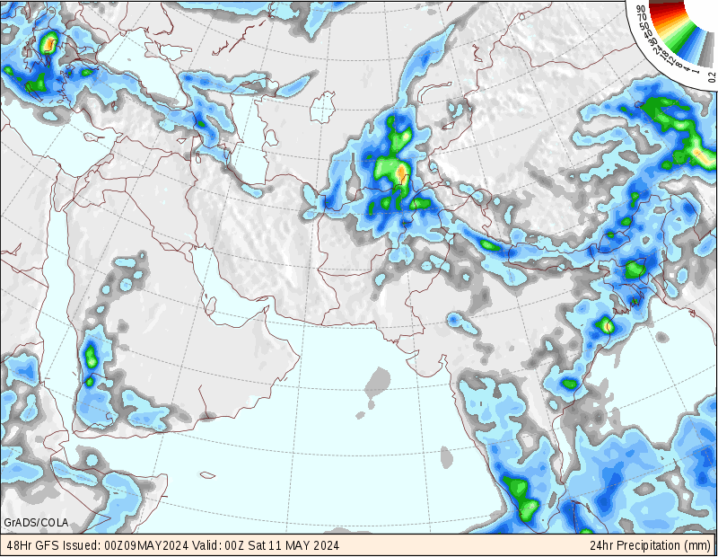
اون حفره بارشی دوباره سمت غرب تهران قرار گرفت!:ناراحت:
Amir Mohsen
متخصص بخش هواشناسی
من عاشق این تشابه مکانی و زمانی پدیده های جوی در شمال شرق ایران با شمال شرق امریکا هستم:
[h=2]Heavy Snow Headed Back to the Northeast
 [h=6]By Kristina Pydynowski, Senior Meteorologist [h=5]March 17, 2013; 1:19 PM
Share |
 An expert analysis on the snowstorm is given in the above AccuWeather.com video.
Yet another snowstorm is taking aim at the Northeast with northern New England and the St. Lawrence Valley bracing for the snowstorm's worst.
After rain and wet snow moves into the southern mid-Atlantic today, snow is set to spread northward from the central Appalachians to New England and the St. Lawrence Valley tonight through Tuesday night.
Enough cold air is even in place for snow and/or a wintry mix to occur across Virginia's Shenandoah Valley this evening through Monday morning.
RELATED:
AccuWeather.com Winter Weather Center
New England Flooding, Coastal Concerns
Upper Midwest Braces for Blizzard Conditions
Severe Weather Threat: Shreveport, Nashville, Birmingham
Disruptive is definitely fitting for this snowstorm with interruptions to daily routines and treacherous travel sure to unfold.
The snow will reach the western I-80 corridor in Pennsylvania by daybreak Monday and just north of the New York State Thruway and western Massachusetts by sunset Monday. By the start of Tuesday, the snow will have begun across the St. Lawrence Valley and most of northern New England.

For a larger version of this map, please visit the AccuWeather.com Winter Weather Center.
The storm will be gaining strength during that time, allowing it to unleash more than a foot of snow in the higher terrain of northern New England by Wednesday.
Widespread amounts of 6 to 12 inches are expected elsewhere across northern New England and the St. Lawrence Valley, including the cities of Burlington, Vt., Concord, N.H., Caribou and Bangor, Maine.
Similar totals (15-30 cm) are also in store for the neighboring Canadian cities of Montreal and Quebec City.

Farther to the south -- along and south of the northern shore of Lake Ontario, the eastern New York State Thruway, the northern Massachusetts border and the coasts of New Hampshire and Maine -- the snow will mix with or change to sleet and/or rain.
However, that will not prevent significant totals from being measured.
AccuWeather.com meteorologists still expect between 6 and 12 inches of snow to accumulate from the Twin Tiers of northern Pennsylvania/southern New York to the Berkshires of Massachusetts.
While heavier totals will be measured to the north and west, residents of Portland, Maine, will be digging out of 4 to 8 inches after the storm winds down Tuesday night.
"As we have warned about this past week, there is potential for the rate of the snow to be intense and the accumulation heavy and wet," stated AccuWeather.com Expert Meteorologist Alex Sosnowski.

"Enough wet, clinging snow can fall to down tree limbs and power lines in some areas," a danger that is greatest from Elmira, N.Y., and Lock Haven, Pa., to Portland, Maine.
Other cities in this threat zone include Binghamton and Albany, N.Y., Pittsfield, Mass., and Concord and Portsmouth, N.H.
Rain, meanwhile, will win out over the snow along the Interstate 95 corridor from Boston to New York City to Philadelphia to Washington, D.C., potentially leading to minor flooding issues in southern New England.
A coating to an inch in Washington, D.C., and Baltimore early Monday and 1-3 inches in Boston early Tuesday could still lead to slow and slick morning commutes. New York City will also see a coating to an inch of snow around sunset, but mainly on non-paved surfaces.
The timing of the snow and/or sleet falling in Philadelphia should prevent travel problems on roadways, but airline passengers should still prepare for flight delays.
[h=2]Heavy Snow Headed Back to the Northeast
Share |
Yet another snowstorm is taking aim at the Northeast with northern New England and the St. Lawrence Valley bracing for the snowstorm's worst.
After rain and wet snow moves into the southern mid-Atlantic today, snow is set to spread northward from the central Appalachians to New England and the St. Lawrence Valley tonight through Tuesday night.
Enough cold air is even in place for snow and/or a wintry mix to occur across Virginia's Shenandoah Valley this evening through Monday morning.
RELATED:
AccuWeather.com Winter Weather Center
New England Flooding, Coastal Concerns
Upper Midwest Braces for Blizzard Conditions
Severe Weather Threat: Shreveport, Nashville, Birmingham
Disruptive is definitely fitting for this snowstorm with interruptions to daily routines and treacherous travel sure to unfold.
The snow will reach the western I-80 corridor in Pennsylvania by daybreak Monday and just north of the New York State Thruway and western Massachusetts by sunset Monday. By the start of Tuesday, the snow will have begun across the St. Lawrence Valley and most of northern New England.
For a larger version of this map, please visit the AccuWeather.com Winter Weather Center.
The storm will be gaining strength during that time, allowing it to unleash more than a foot of snow in the higher terrain of northern New England by Wednesday.
Widespread amounts of 6 to 12 inches are expected elsewhere across northern New England and the St. Lawrence Valley, including the cities of Burlington, Vt., Concord, N.H., Caribou and Bangor, Maine.
Similar totals (15-30 cm) are also in store for the neighboring Canadian cities of Montreal and Quebec City.
Farther to the south -- along and south of the northern shore of Lake Ontario, the eastern New York State Thruway, the northern Massachusetts border and the coasts of New Hampshire and Maine -- the snow will mix with or change to sleet and/or rain.
However, that will not prevent significant totals from being measured.
AccuWeather.com meteorologists still expect between 6 and 12 inches of snow to accumulate from the Twin Tiers of northern Pennsylvania/southern New York to the Berkshires of Massachusetts.
While heavier totals will be measured to the north and west, residents of Portland, Maine, will be digging out of 4 to 8 inches after the storm winds down Tuesday night.
"As we have warned about this past week, there is potential for the rate of the snow to be intense and the accumulation heavy and wet," stated AccuWeather.com Expert Meteorologist Alex Sosnowski.
"Enough wet, clinging snow can fall to down tree limbs and power lines in some areas," a danger that is greatest from Elmira, N.Y., and Lock Haven, Pa., to Portland, Maine.
Other cities in this threat zone include Binghamton and Albany, N.Y., Pittsfield, Mass., and Concord and Portsmouth, N.H.
Rain, meanwhile, will win out over the snow along the Interstate 95 corridor from Boston to New York City to Philadelphia to Washington, D.C., potentially leading to minor flooding issues in southern New England.
A coating to an inch in Washington, D.C., and Baltimore early Monday and 1-3 inches in Boston early Tuesday could still lead to slow and slick morning commutes. New York City will also see a coating to an inch of snow around sunset, but mainly on non-paved surfaces.
The timing of the snow and/or sleet falling in Philadelphia should prevent travel problems on roadways, but airline passengers should still prepare for flight delays.
اون حفره بارشی دوباره سمت غرب تهران قرار گرفت!:ناراحت:
درود ارش جان . تهران پایین اون قسمت البرز هست که جهت رشته کوه عوض شده . حفره میوفته شهر ری به پایین .
Mohammad-rasht
کاربر ويژه
دی ماه 91
منبع:اداره کل هواشناسی استان گیلان
[TD]
[/TD]
[TD]
[/TD]
[TD]
[/TD]
[TD]
[/TD]
[TD]
[/TD]
[TD]
[/TD]
[TD]
[/TD]
[TD]
[/TD]
[TR]
[TD]
[/TD]
[TD]
[/TD]
[TD]
[/TD]
[TD]
[/TD]
[TD]
[/TD]
[TD]
[/TD]
[TD]
[/TD]
[TD]
[/TD]
[TD]
[/TD]
[/TR]
[TR]
[TD]
[/TD]
[TD]
[/TD]
[TD]
[/TD]
[TD]
[/TD]
[TD]
[/TD]
[TD]
[/TD]
[TD]
[/TD]
[TD]
[/TD]
[TD]
[/TD]
[/TR]
[TR]
[TD]
[/TD]
[TD]
[/TD]
[TD]
[/TD]
[TD]
[/TD]
[TD]
[/TD]
[TD]
[/TD]
[TD]
[/TD]
[TD]
[/TD]
[TD]
[/TD]
[/TR]
[TR]
[TD]
[/TD]
[TD]
[/TD]
[TD]
[/TD]
[TD]
[/TD]
[TD]
[/TD]
[TD]
[/TD]
[TD]
[/TD]
[TD]
[/TD]
[TD]
[/TD]
[/TR]
[TR]
[TD]
[/TD]
[TD]
[/TD]
[TD]
[/TD]
[TD]
[/TD]
[TD]
[/TD]
[TD]
[/TD]
[TD]
[/TD]
[TD]
[/TD]
[TD]
[/TD]
[/TR]
[TR]
[TD]
[/TD]
[TD]
[/TD]
[TD]
[/TD]
[TD]
[/TD]
[TD]
[/TD]
[TD]
[/TD]
[TD]
[/TD]
[TD]
[/TD]
[TD]
[/TD]
[/TR]
[TR]
[TD]
[/TD]
[TD]
[/TD]
[TD]
[/TD]
[TD]
[/TD]
[TD]
[/TD]
[TD]
[/TD]
[TD]
[/TD]
[TD]
[/TD]
[TD]
[/TD]
[/TR]
[TR]
[TD]
[/TD]
[TD]
[/TD]
[TD]
[/TD]
[TD]
[/TD]
[TD]
[/TD]
[TD]
[/TD]
[TD]
[/TD]
[TD]
[/TD]
[TD]
[/TD]
[/TR]
[TR]
[TD]
[/TD]
[TD]
[/TD]
[TD]
[/TD]
[TD]
[/TD]
[TD]
[/TD]
[TD]
[/TD]
[TD]
[/TD]
[TD]
[/TD]
[TD]
[/TD]
[/TR]
[TR]
[TD]
[/TD]
[TD]
[/TD]
[TD]
[/TD]
[TD]
[/TD]
[TD]
[/TD]
[TD]
[/TD]
[TD]
[/TD]
[TD]
[/TD]
[TD]
[/TD]
[/TR]
[TR]
[TD]
[/TD]
[TD]
[/TD]
[TD]
[/TD]
[TD]
[/TD]
[TD]
[/TD]
[TD]
[/TD]
[TD]
[/TD]
[TD]
[/TD]
[TD]
[/TD]
[/TR]
نقشه هاي هم مقدار
دی 91

نقشه هم نم نسبی

نقشه هم باران

نقشه هم دما
تا دی ماه فقط موجود بود.
منبع:اداره کل هواشناسی استان گیلان
| شهرستان |
[TD]
حداقل مطلق دما
[/TD]
[TD]
زمان وقوع
[/TD]
[TD]
حداکثر مطلق
دما
[/TD]
[TD]
زمان وقوع
[/TD]
[TD]
میانگین حداقل دما
[/TD]
[TD]
میانگین حداکثر دما
[/TD]
[TD]
میانگین ماهیانه
[/TD]
[TD]
نرمال
[/TD]
[TR]
[TD]
رشت
[/TD]
[TD]
3.0-
[/TD]
[TD]
27
[/TD]
[TD]
22.2
[/TD]
[TD]
19
[/TD]
[TD]
2.3
[/TD]
[TD]
12.9
[/TD]
[TD]
7.6
[/TD]
[TD]
7.8
[/TD]
[/TR]
[TR]
[TD]
انزلی
[/TD]
[TD]
0.8
[/TD]
[TD]
27
[/TD]
[TD]
22.4
[/TD]
[TD]
19
[/TD]
[TD]
5.0
[/TD]
[TD]
12.1
[/TD]
[TD]
8.6
[/TD]
[TD]
8.5
[/TD]
[/TR]
[TR]
[TD]
لاهیجان
[/TD]
[TD]
3.0-
[/TD]
[TD]
28
[/TD]
[TD]
21.8
[/TD]
[TD]
19
[/TD]
[TD]
1.9
[/TD]
[TD]
13.5
[/TD]
[TD]
7.7
[/TD]
[TD]
7.6
[/TD]
[/TR]
[TR]
[TD]
آستارا
[/TD]
[TD]
2.0-
[/TD]
[TD]
27
[/TD]
[TD]
16.4
[/TD]
[TD]
29
[/TD]
[TD]
2.0
[/TD]
[TD]
10.2
[/TD]
[TD]
6.1
[/TD]
[TD]
6.6
[/TD]
[/TR]
[TR]
[TD]
منجیل
[/TD]
[TD]
3.2-
[/TD]
[TD]
27
[/TD]
[TD]
20.0
[/TD]
[TD]
19
[/TD]
[TD]
3.4
[/TD]
[TD]
14.0
[/TD]
[TD]
8.7
[/TD]
[TD]
8.2
[/TD]
[/TR]
[TR]
[TD]
ماسوله
[/TD]
[TD]
6.0-
[/TD]
[TD]
7
[/TD]
[TD]
16.0
[/TD]
[TD]
9
[/TD]
[TD]
1.2
[/TD]
[TD]
9.4
[/TD]
[TD]
5.3
[/TD]
[TD]
_
[/TD]
[/TR]
[TR]
[TD]
تالش
[/TD]
[TD]
1.0-
[/TD]
[TD]
27
[/TD]
[TD]
22.6
[/TD]
[TD]
19
[/TD]
[TD]
4.0
[/TD]
[TD]
11.6
[/TD]
[TD]
7.8
[/TD]
[TD]
_
[/TD]
[/TR]
[TR]
[TD]
جیرنده
[/TD]
[TD]
8.0-
[/TD]
[TD]
27
[/TD]
[TD]
11.8
[/TD]
[TD]
4
[/TD]
[TD]
1.6-
[/TD]
[TD]
5.0
[/TD]
[TD]
1.7
[/TD]
[TD]
_
[/TD]
[/TR]
[TR]
[TD]
دیلمان
[/TD]
[TD]
12.0-
[/TD]
[TD]
27
[/TD]
[TD]
13.4
[/TD]
[TD]
4
[/TD]
[TD]
1.0-
[/TD]
[TD]
7.9
[/TD]
[TD]
3.5
[/TD]
[TD]
_
[/TD]
[/TR]
[TR]
[TD]
رودسر
[/TD]
[TD]
1.2-
[/TD]
[TD]
9
[/TD]
[TD]
22.2
[/TD]
[TD]
19
[/TD]
[TD]
3.2
[/TD]
[TD]
12.2
[/TD]
[TD]
7.7
[/TD]
[TD]
_
[/TD]
[/TR]
[TR]
[TD]
کیاشهر
[/TD]
[TD]
1.6-
[/TD]
[TD]
27
[/TD]
[TD]
21.2
[/TD]
[TD]
19
[/TD]
[TD]
3.5
[/TD]
[TD]
12.4
[/TD]
[TD]
8.0
[/TD]
[TD]
_
[/TD]
[/TR]
نقشه هاي هم مقدار
دی 91
نقشه هم نم نسبی
نقشه هم باران
نقشه هم دما
تا دی ماه فقط موجود بود.
من عاشق این تشابه مکانی و زمانی پدیده های جوی در شمال شرق ایران با شمال شرق امریکا هستم:
Heavy Snow Headed Back to the Northeast
By Kristina Pydynowski, Senior Meteorologist
March 17, 2013; 1:19 PM
Share |
An expert analysis on the snowstorm is given in the above AccuWeather.com video.
Yet another snowstorm is taking aim at the Northeast with northern New England and the St. Lawrence Valley bracing for the snowstorm's worst.
After rain and wet snow moves into the southern mid-Atlantic today, snow is set to spread northward from the central Appalachians to New England and the St. Lawrence Valley tonight through Tuesday night.
Enough cold air is even in place for snow and/or a wintry mix to occur across Virginia's Shenandoah Valley this evening through Monday morning.
RELATED:
AccuWeather.com Winter Weather Center
New England Flooding, Coastal Concerns
Upper Midwest Braces for Blizzard Conditions
Severe Weather Threat: Shreveport, Nashville, Birmingham
Disruptive is definitely fitting for this snowstorm with interruptions to daily routines and treacherous travel sure to unfold.
The snow will reach the western I-80 corridor in Pennsylvania by daybreak Monday and just north of the New York State Thruway and western Massachusetts by sunset Monday. By the start of Tuesday, the snow will have begun across the St. Lawrence Valley and most of northern New England.
For a larger version of this map, please visit the AccuWeather.com Winter Weather Center.
The storm will be gaining strength during that time, allowing it to unleash more than a foot of snow in the higher terrain of northern New England by Wednesday.
Widespread amounts of 6 to 12 inches are expected elsewhere across northern New England and the St. Lawrence Valley, including the cities of Burlington, Vt., Concord, N.H., Caribou and Bangor, Maine.
Similar totals (15-30 cm) are also in store for the neighboring Canadian cities of Montreal and Quebec City.
Farther to the south -- along and south of the northern shore of Lake Ontario, the eastern New York State Thruway, the northern Massachusetts border and the coasts of New Hampshire and Maine -- the snow will mix with or change to sleet and/or rain.
However, that will not prevent significant totals from being measured.
AccuWeather.com meteorologists still expect between 6 and 12 inches of snow to accumulate from the Twin Tiers of northern Pennsylvania/southern New York to the Berkshires of Massachusetts.
While heavier totals will be measured to the north and west, residents of Portland, Maine, will be digging out of 4 to 8 inches after the storm winds down Tuesday night.
"As we have warned about this past week, there is potential for the rate of the snow to be intense and the accumulation heavy and wet," stated AccuWeather.com Expert Meteorologist Alex Sosnowski.
"Enough wet, clinging snow can fall to down tree limbs and power lines in some areas," a danger that is greatest from Elmira, N.Y., and Lock Haven, Pa., to Portland, Maine.
Other cities in this threat zone include Binghamton and Albany, N.Y., Pittsfield, Mass., and Concord and Portsmouth, N.H.
Rain, meanwhile, will win out over the snow along the Interstate 95 corridor from Boston to New York City to Philadelphia to Washington, D.C., potentially leading to minor flooding issues in southern New England.
A coating to an inch in Washington, D.C., and Baltimore early Monday and 1-3 inches in Boston early Tuesday could still lead to slow and slick morning commutes. New York City will also see a coating to an inch of snow around sunset, but mainly on non-paved surfaces.
The timing of the snow and/or sleet falling in Philadelphia should prevent travel problems on roadways, but airline passengers should still prepare for flight delays.
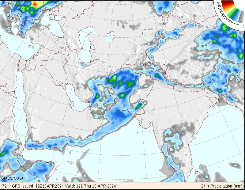
اوه اوه! بارش باران و بعد هم یخبندان! دشمن اصلی خطوط انتقال نیرو!
درود ارش جان . تهران پایین اون قسمت البرز هست که جهت رشته کوه عوض شده . حفره میوفته شهر ری به پایین .
محمد جان تاثیر منفی اش رو روی کل شهر میگذاره! دفعات قبلی هم همینطور شد.
ali.doosti
کاربر ويژه
علی جان این حالت در خورستان کاملا طبیعی هست، ابر تندری اسفند به بعد بارش قابلی نداره مگر این که رطوبت واقعا درست و درمانی به همراه داشته باشه، یادش بخیر، سال 75 شب رفتم توی حیاط دیدم انگار خونه همسایه رو دارن با فلاش روشن میکنند! برگشتم پشت سرم رو نگاه کردم و WOOOOOOOOOOOOOOW!!!
دیوار رعد و برق بود که میومد به سمت اهواز! هر ثانیه بیشتر از 2 رعد وبرق میزد! تمام آسمان روشن بود! حیف که اون زمان مثل الان دوربین و لوازم فیلم برداری نبود، خلاصه توده ابر به شهر رسید وبعد از کلی سر و صدا و وزش باد شدید و گرد و خاک، بارش کمی نازل شد و تمام!
پس زیاد ناراحت نباش، فصل گرم خوزستان درحال شروع شدن هست و متاسفانه باید برای گرماهایشدید آماده بشید.
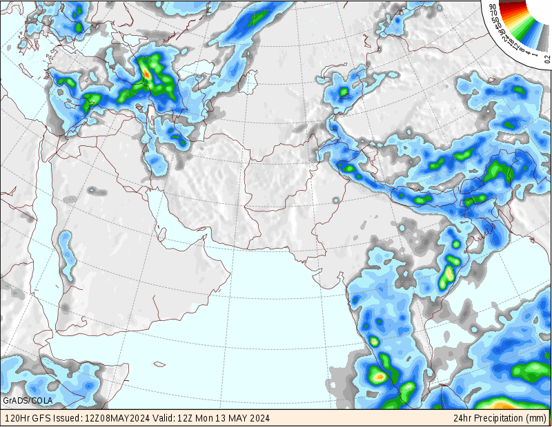
درود آرش عزیز
ولی برای دزفول ما فرورذین یکی از ماه های پربارشه و همین ابر اگر شرایط نرمال بود باران های دونه درشتو شدیدی راه مینداخت که صد تا زمستون به پاش نمیرسیدن!یه جای کار میلنگه...طبیعی نیست این چیزا!
البته یه ده دقیقه ای دوباره زد 1م.متری اومد!بایددید امشب چه گلی به سرمون میزنن...
البته هنوز وقت هست تا آخراردیبهشت ولی حیف این فرصت ها از دست بره...
محمد بجنورد
کاربر ويژه

درود آرش عزیز
ولی برای دزفول ما فرورذین یکی از ماه های پربارشه و همین ابر اگر شرایط نرمال بود باران های دونه درشتو شدیدی راه مینداخت که صد تا زمستون به پاش نمیرسیدن!یه جای کار میلنگه...طبیعی نیست این چیزا!
البته یه ده دقیقه ای دوباره زد 1م.متری اومد!بایددید امشب چه گلی به سرمون میزنن...
البته هنوز وقت هست تا آخراردیبهشت ولی حیف این فرصت ها از دست بره...
دزفول کلا آب و هوای بهتری نسبت به اهواز داره، حداقل 4-5 درجه خنکتر هست، برای همین هم درختان مرکبات اونجا بخوبی عمل میاد، اهواز درخت نفسش گرفته میشه! تنها درختی که اهواز خوب بار میده بعد از خرما، کنار یا همون سدر هست!
آخرین ویرایش:
محمد بجنورد
کاربر ويژه

بنظر میاد من اشتباه کردم!!!هواشناسی کشور درست پیش بینی کرده بود!!!{پیش بینی اختصاصیش واسه مشهد}

محمد بجنورد
کاربر ويژه
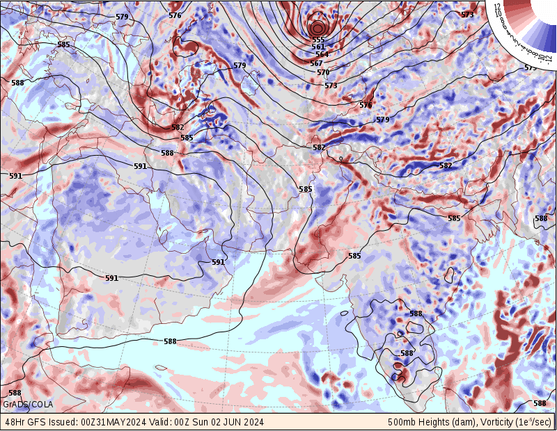
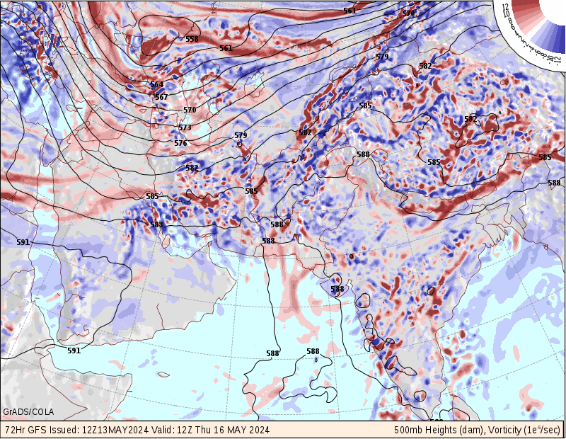
از اساتید عزیز درخواست میکنم که تحلیلی مختصر درمورد تراز500میلی بار ارائه دهند لطفا:گل::احترام:
Amir Mohsen
متخصص بخش هواشناسی
اوه اوه! بارش باران و بعد هم یخبندان! دشمن اصلی خطوط انتقال نیرو!
سلام آرش جان
دقیقا همینطوره:
سقوط درختان- قطع خطوط برق و ..................
از خصوصیات بارشهای برف در این موقع از سال هستند: مثل 17 اسفند مشهد
سلام آرش جان
دقیقا همینطوره:
سقوط درختان- قطع خطوط برق و ..................
از خصوصیات بارشهای برف در این موقع از سال هستند: مثل 17 اسفند مشهد
امیرمحسن عزیز فکر میکنم برای اون منطقه سرما بیشتر از بارش برف 17 اسفند ما هست و به همین دلیل صدمه بیشتری میزنه.
Mohammad-rasht
کاربر ويژه
اختلاف دمای بیشینه و کمینه امروز رشت 3.4 درجه سانتیگراد بود.
همچنین رشت با بیشینه 13.6 درجه سانتیگراد خنک ترین مرکز کشور در دمای بیشینه بود.
دمای فعلی:10 نسبت به دیشب همین موقع 1 درجه خنک تر شده.
تا اواسط هفته آینده اوضاع دمایی رشت خوبه و شاید در کل از نرمال این موقع از سال مقداری کمتر باشه.
همچنین رشت با بیشینه 13.6 درجه سانتیگراد خنک ترین مرکز کشور در دمای بیشینه بود.
دمای فعلی:10 نسبت به دیشب همین موقع 1 درجه خنک تر شده.
تا اواسط هفته آینده اوضاع دمایی رشت خوبه و شاید در کل از نرمال این موقع از سال مقداری کمتر باشه.
Amir Mohsen
متخصص بخش هواشناسی
به به به این میگن یک اخطاریه درست و حسابی و به موقع:گل:
دست این دوستان عزیز و زحمتکشون هم درد نکنه و خسته نباشند:گل:
محمد بجنورد
کاربر ويژه
به به به این میگن یک اخطاریه درست و حسابی و به موقع:گل:
دست این دوستان عزیز و زحمتکشون هم درد نکنه و خسته نباشند:گل:
ظاهرا گفتمان ها و مذاکرات جناب مهندس میری و امیر عزیز مثمر ثمر واقع شده!!!:خنده1::خنده1:
- وضعیت
- موضوع بسته شده است.