• توجه: در صورتی که از کاربران قدیمی ایران انجمن هستید و امکان ورود به سایت را ندارید، میتوانید با آیدی altin_admin@ در تلگرام تماس حاصل نمایید.

تجزیه و تحلیل وضعیت جوی در سال زراعی 93-94 /فصل دوم( دي- بهمن-اسفند)

وضعیت
موضوع بسته شده است.

rahsazan

کاربر ويژه
اطلاعیه شماره 29 مورخ 93/10/17

نقشه ها و مدل هاي هواشناسينشان دهنده نفوذجریانات ناپایدارجوی به سمت شمال شرق کشورمی باشد که پیش بینی می شود طی امروز و بویژه فردا( پنج شنبه 18/10/93 ) در برخی نقاط استان وزش بادنسبتاً شدیدتا شدید باشد( در نواحی شرقی و شمالی ، افزایش شدت وزش باد محسوس تر خواهد بود)
از بعداز ظهر فردا با شمالی شدن جریانات و تقویت سامانه ناپایدارجوی ، افزایش ابرناکی و کاهش محسوس دما در سطح استان حادث ، که افت دما در نیمه شمالی استان 10تا 12درجه و در نواحی جنوبی بین 8 تا 10 درجه سلسیوس پیش بینی شده است.


      • شروع بارش ها از بعداز ظهر فردا و از نواحی غربی استان خواهد بودکه بتدریج غالب نقاط خصوصا نیمه شمالی استان تحت تأثیر این سامانه قرار می گیرد .


    [*]بیشترین حجم بارش در نیمه شمالی استان و بشکل برف رخ خواهد داد.
    [*]ماندگاری هوای سرد در سطح استان، تا اواسط هفته آینده ادامه خواهد داشت.
    [*]در طی فعالیت این سامانه ، بعلت وزش باد (در برخی نقاط گردوخاک ) و در ادامه با توجه به بارش باران و برف ( کولاک برف ) ، تشکیل مه ، کاهش دید و لغزندگی محورهای مواصلاتی ، احتمال اختلال در سیستم حمل و نقل استان دور از انتظار نمی باشد.
    [*]


ماریا67

New member
سلام و درود
با توجه به این دریای خزر این چند روزه هوا گرم بود و امروزم بیشتر از پیشبینی ها هوا اون منطقه گرم شده بود و هوای سرد از روی این منطقه عبور میکنه و سمت ما میاد احتمال داره بارشها در شمال شرق و مشهد فراتر از پیشبینی ها باشه. اینو براساس تجربه میگم. ان شاءالله که همینطور بشه.
 

rahsazan

کاربر ويژه
وضع هوای ارومیه

هوای حاضر ساعت: ۱۳:۳۱
پیش بینی ۳ روز آینده


D_33_XL.png
۳° c
رگبار برف

جهت باد: جنوب غربی​
arrow1.gif
هوای حاضر | چهارشنبه ۱۷ دی

سرعت باد: ۶ متر بر ثانیه, ۲۲ کیلومتر بر ساعت

نم نسبی: % ۷۵

دید افقی: ۹۰۰۰متر

بارندگی 24 ساعت گذشته: ۰.۶ میلیمتر

بیشینه دما در 24 ساعت گذشته: ۱۲° c

کمینه دما در 24 ساعت گذشته: ۲° c
update.png
آخرین بروز رسانی: ۱۳۹۳/۱۰/۱۷ ۱۳:۲۱


از زمستون خواهش مندیم که ادای تابستون رو در نیاره و خودش باشه
ما بسی هوای خوب و بدون بارش داریم عین تابستونا :/
 

seyyedalireza

مدیر موقت
دمای مشهد بیست درجه خخخ الان توی تابستون هستیم . ولی این خبر یک خبر بسیار عالی برای ما هستش به قول قدیمی ها بعد از هر گرمای نا متعارف در زمستون منتظر برف شدیدی باشين
 

DR WHO

کاربر ويژه
UK weather warnings issued ahead of 'unusually strong' jet stream moving across the Atlantic
Gales of up to 80mph are expected to batter most of the UK by the end of the week.

Temperatures will alternate between freezing and mild because of an "unusually strong" 230mph jet stream, and several parts of the country can expect sleet as temperatures drop to -4c on Tuesday, with potential snow flurries by the weekend.


COLDEST WEATHER OF THE SEASON THIS WEEK! BRING ME SOME OF THAT “PURPLE”
Jan 4, 2015


Before I get to the good news, let me go ahead and get the nasty stuff out of the way. The weather thus far this winter has been the pits. We’ve had to resort to talking about how nice the snow was at Vail last week; we’ve had to continually talk about how great the snowmakers and maintainers at the various resorts are (and they are) AND we’ve had to talk about “cold weather being on the way” already more times this season that in the previous four or five years.
Saturday was a WET ONE and today doesn’t look a whole lot better.

2015-01-04-snow-dance.jpg
One of our long-time readers emailed me last night saying, “Mike, you guys have always done a fabulous job of keeping us informed about what to expect on the mountains. I know a few years ago when the weather was warm, you guys did a contest for snow dances. Maybe it’s time to think about doing one for this season.”
 

DR WHO

کاربر ويژه
امسال دقيقا همون پارساله با يه ماه تاخير

الان آذر ١٣٩٢

تمام حوداث پارسال جهان داره تكرار ميشه!!!!

Q: What's next?
A: Temperatures are expected to be lower than normal for days but could rise a bit by the end of the week.
"We have cold temperatures, but it's not like it never happened before," said Bob Oravec, a meteorologist with the Weather Prediction Center in College Park, Md. "It's typical for an Arctic outbreak."


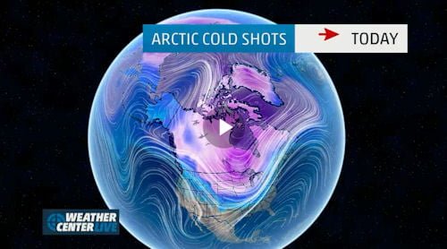
polar air to spill south, bringing the coldest weather of the season so far, reminiscent of last year’s polar vortex – on its exact one-year anniversary.
It won’t be quite as bad as 2014 – this is not the return of the full polar vortex but is a piece of that fridge whirlpool. It will feel as bad, said Pocono weather expert Ben Gelber, long-time East Stroudsburg resident and NBC meteorologist in Columbus, Ohio.
“What’s amazing to me is its happening to the day. Last year our true encounter with the polar vortex held temperatures to the single digits with wind chills of 24 to 32 below zero. And it all happened on Jan. 7. We had a 54 degree temperature drop in 24 hours last year between Jan. 6 and Jan.7,” Gelber said.
Wednesday and Thursday will be our bitterest days with temperatures falling through the teens with strong winds, snow showers and brutal wind chill values probably approaching minus 20 to minus 30 degrees.
"Wednesday night should be the coldest night with excruciating wind chills. Temperatures should drop to zero to minus 5 Thursday morning with wind chills of minus 10 to 20 below," Gebler said.
The weather could cause some school delays.
“It’s going to be a harsh reminder of the bitterness of last year.”


DR WHO

کاربر ويژه
  1. [h=3]Brutal Cold to Blast Eastern Half of US, Challenge Records in Midwestwww.accuweather.com/en/weather-news/brutal-cold...east-next.../39958655

    2 hours ago - In a weather pattern common for January, waves of arctic air will flow ... Africa; Antarctica; Arctic; Asia; Central America; Europe; Middle East ...


    In the news
  2. Snow falls in Middle East as strong winter storm strikes - Omaha.com: NationOmaha.com‎ - 4 hours ago

    Wintry weather is striking across the Middle East, bringing cold .... storm strikes · As snow moves out, 'dangerously cold air' on the way · As ...

    Is This What Polar Vortex 2015 Feels like in Boston?

    Nate Boroyan - City News Writer 01/06/15 @3:14pm in City News

    263
    flameScore.png


    streetcred.png
    streetcred

    twitter

    facebook.png
    facebook

    social_share.png
    share


    Screen-Shot-2015-01-06-at-2.01.58-PM-1024x555.png


    If you're outside at the moment, in Boston, you're doing it wrong. It's not the off-and-on snow flurries that are troublesome; it's the piercing cold, and how it makes your face – especially the skin around your eyeballs, nose and the top of your ears – instantly feel once you venture out into it that's the #worst. Polar Vortex, part deux.
    Except not really. A polar vortex – like the Polar Vortex of 2014 felt in Boston – is a giant bubble of wicked cold air, "typically the coldest air in the Northern Hemisphere," which parks itself over the polar region during the winter months. What causes cities such as Boston to feel the body- and mind-numbing effects of a Polar Vortex is, what meteorologists like yours truly would call Science, with a capital "S."
    The deathly cold hovering above the arctic can, according to Accuweather.com, get pushed down as far south as the U.S.-Canadian border, the northern plains, Midwest, and unfortunately – obviously – the Northeast. For this to happen, an uberpowerful high pressure system over dominating the Pacific, ranging all the way up to Alaska, or even the North Pole, has to disrupt the Polar Vortex and cause it to funnel cold air further south. #marketexpansion
    When polar-vortex colds launch in cities like Boston, they can linger for days at a time; we're forced to adjust to the frigidness for as long as the disruptor system over the Pacific keeps growing in strength. Fortunately, the freemarket state of Earth's atmosphere dictates this high pressure system won't last forever; weather patterns are regulate themselves – organically. "When the strong air from the Eastern or Western Pacific weakens and falls apart, the polar vortex will retreat into place near the North Pole," Accuweather.com states.
    So in Boston, where temperatures could feel as low as -25 degrees Thursday morning, are we allowed to call this Polar Vortex 2015? Technically, no.
    The International Business Times reports that the cold stream currently turning us all into walking ice zombies, at this moment, lingers about 4 to 9 miles above the Earth's surface, pulling in frosts blast from the Artic. Since the polar vortex is located 12 miles above the surface, up by the North Pole, well, Polar Vortex 2015 isn't a thing.
    It's cold and awful, right now. But it could be worse. #blessed
    #SMH
    Images/Public Domain


DR WHO

کاربر ويژه
[h=2]Brutal Cold to Blast Eastern Half of US, Challenge Records in Midwest
sosnowski.png
[h=6]By Alex Sosnowski, Expert Senior Meteorologist[h=5]January 7, 2015; 3:29 AM ET
More Sharing ServicesShare|Share on facebookShare on twitterShare on linkedin


In a weather pattern common for January, waves of arctic air will flow from the Midwest to the Northeast and South into the coming weekend.
The waves of arctic air coming in this week will be painful for those who have to spend time outdoors, unless properly dressed. In addition to the below-average temperatures forecast, AccuWeather.com RealFeel® Temperatures will be 15-30 degrees lower than the actual temperature at times.
RealFeel Temperatures will plunge well below zero at times in the Midwest and Northeast. The cold will spend multiple hours at dangerously low and life-threatening levels. The pattern will raise the risk of frostbite and hypothermia. Don't forget to bring any outside pets indoors to protect them from the bitter cold.
650x366_01052013_hd27-1.jpg

People in the South will want to make preparations to prevent pipes from freezing. Either insulate exposed pipes or shut off water and drain these vulnerable areas to avoid costly damage.
While the pattern this week will send some chilly air into the Deep South, it should not get cold enough for a damaging frost or freeze in central and South Florida.
RELATED:
Clipper System to Bring Burst of Snow and Delays for DC, Philly and NYC
Check AccuWeather MinuteCast® for Your Location
AccuWeather Winter Weather Center 2015

According to AccuWeather Chief Meteorologist Elliot Abrams, "Since temperatures dropped below freezing in New York City Monday evening, they may not get back above freezing until this weekend."
"In Chicago, it may not be until late next week before temperatures climb back above freezing."
The first blast of air sent temperatures below zero over the northern Plains and the Upper Midwest to start the week and caused temperatures to fall during the middle of the day in the coastal Northeast.
A second, stronger blast of arctic air rolled into the Midwest on Tuesday following a storm, known as an Alberta Clipper. The storm spread a swath of light to moderate snow from the northern Plains to the mid-Atlantic coast.
In many cases, air following the Alberta Clipper will bring the lowest temperatures since last winter spanning Wednesday and Thursday.
RealFeel Temperatures Tuesday night ranged in the minus 30s to minus 40s across the Dakotas, Minnesota, and Iowa.
650x366_01051653_hd33.jpg

Temperatures may struggle to get above zero F in Chicago and Minneapolis on Wednesday, where nighttime low temperatures will dip well below zero on multiple nights during the middle and second half of the week.
Record low temperatures set 70 to nearly 130 years ago will be challenged in parts of the Midwest on Wednesday night into early Thursday. The record at Chicago is minus 11 F, set in 1942 for Thursday morning. The record at Des Moines, Iowa, is minus 17 F set in 1886 for the same morning.
Temperatures will fall into the single digits in the central Appalachians on Wednesday and may drop below zero in Boston and along the New England coast by Thursday morning.
Highs will only be in the 20s in Washington, D.C., on Thursday despite sunshine.
Lows will be in the teens and 20s over much of the interior South for the middle and second half of the week. Highs will range from the upper 30s to the lower 40s from Jackson, Mississippi, to Birmingham, Alabama, Atlanta and Charlotte, North Carolina.
According to AccuWeather Senior Meteorologist Brett Anderson, "Rather than the pattern lock in for the remainder of the month, it looks like temperatures will moderate at mid-month from the Central states to the East."
Whether the warmup will last a couple of days or a week or more is uncertain at this time.
Warm and dry conditions are in store for much of the West into the coming weekend.
 

ali_kermanshah

کاربر ويژه
کم کم ابر های سیستم دارن از سمت غرب ظاهر میشن ...
 

پیوست ها

  • uploadfromtaptalk1420629868938.jpg
    uploadfromtaptalk1420629868938.jpg
    733.6 کیلوبایت · بازدیدها: 9

DR WHO

کاربر ويژه
Snow falls in Middle East as strong winter storm strikes

By HUSSEIN MALLA | Updated 10 minutes ago
ANJAR, Lebanon (AP) — Snow fell Wednesday across the Middle East as a powerful winter storm swept through the region, forcing Syrians who have fled their country's civil war to huddle for warmth in refugee camps.


The storm dumped rain and hail on Lebanon's coast and heavy snows in the mountains and central Bekaa Valley, where gas stations, banks, schools and most shops closed.

While the storm disrupted life for everyone, it proved particularly trying for the hundreds of thousands of Syrian refugees who live in tents and makeshift shelters in the Bekaa.

Near the town of Anjar, men used brooms and sticks to try to clear the heavy snow from the tops of refugee tents, fearing the weight might cause the shelters to collapse. Inside the tents, adults could be seen huddling around the wood burning stoves to try to keep warm.

Elsewhere, Palestinian authorities in the West Bank and Gaza Strip declared a state of emergency over the storm. An 8-month-old Palestinian infant in the Tulkarem refugee camp killed in a fire caused by a heating stove, Palestinian civil defense ministry spokesman Loae Bani Odeh said.

Snow accumulated in the Golan Heights and northern Israel. Schools across Jerusalem closed ahead of a forecast warning of 10 inches (25 centimeters) of snowfall.

In Syria, snow blanketed Qassioun Mountain, which overlooks Damascus. The snowfall also brought traffic to a near standstill in the capital, Damascus, and prompted the Education Ministry to shutter school and universities for two days.

Heavy fogs also blanketed parts of Pakistan on Wednesday morning. Pakistan's Civil Aviation Authority said officials temporarily closed Islamabad's Benazir Bhutto International Airport due to the weather, diverting incoming flights to Lahore.

___

Associated Press writers contributing to this report include Mohammed Daraghmeh in Ramallah, West Bank; Fares Akram in Gaza City, Gaza Strip; Daniel Estrin in Jerusalem; Ryan Lucas in Beirut; Albert Aji in Damascus, Syria; Merrit Kennedy in Cairo and Rebecca Santana in Islamabad.

___

Follow Hussein Malla on Twitter at www.twitter.com/hmalla72 .

This video player must be at least 300x168 pixels in order to oper
 
وضعیت
موضوع بسته شده است.
بالا