• توجه: در صورتی که از کاربران قدیمی ایران انجمن هستید و امکان ورود به سایت را ندارید، میتوانید با آیدی altin_admin@ در تلگرام تماس حاصل نمایید.

تجزیه و تحلیل وضعیت جوی در سال زراعی 93-94 /فصل سوم( فروردین- اردیبهشت-خرداد)

وضعیت
موضوع بسته شده است.

وحید - مشهد

کاربر ويژه
اطلاعیه شماره 26 دوشنبه مورخ 94/03/18 ویژه توفان دریایی 01A
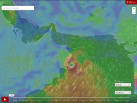
بررسی نقشه های پیش یابی هواشناسی و آخرین تصاویر دریافتی از ماهواره های هواشناسی بیانگر شکل گیری طوفان حاره ای در شمال اقیانوس هند با موقعیت 17 درجه و 55 دقیقه شمالی و 66 درجه و 30 دقیقه شرقی و در فاصله تقریبی 1300 کیلومتری شهرستان چابهار درجنوب شرق سیستان و بلوچستان است. سرعت متوسط باد درپیرامون این طوفان 75 و سرعت متوسط حرکت آن حدود 10 کیلومتر بر ساعت به سوی شمال غرب می باشد. با توجه به پیش بینی حرکت این طوفان به عرضهای بالاتر، از اواخر روز سه شنبه مناطق شرقی دریای عمان و از روز چهارشنبه تا پایان هفته جاری بیشتر مناطق دریای عمان مواج و طوفانی پیش بینی می شود. پیش بینی دقیق تر ارتفاع موج و سرعت باد در اطلاعیه روز سه شنبه مورخ 94/03/19 اعلام خواهد شد.
 

وحید - مشهد

کاربر ويژه
ks3nkokz4508vqkck.gif
 

mrdn

New member
فعلا نقشه ها در مورد طوفان تا حدودي اختلاف نظر دارند.ولي اميدوارم بارش هاي عالي و بدون خطري براي هموطنان جنوب كشور داشته باشه
 

tima ir

کاربر ويژه
سلام
در اپدیت قبلی مرکز اصلی این طوفان در این نقشه به سمت چابهار و تنگه هرمز حرکت میکرد و بیشترین فعالیت رو برای اواخر هفته اینده زده بود ولی فعلا به سمت غرب خودش و کشور عمان وامارات تغییر مسیر داده و به هر حال نواحی جنوبی شرقی کشور ما رو هم تحت تاثیر قرار خواهد داد .

30 ساعات اینده


96 ساعت اینده

 
آخرین ویرایش:

samann

کاربر ويژه
عاشق اين ركورد زني هاي امسالم. گويا در اخرين روزهاي خرداد ميخواد دماي مشهد به 40 برسه.
پارسال اگه اشتباه نكنم ماكزيمم دماي تابستون به 40 رسيد ولي امسال مثه اب خوردن نه در اواخر تير و اوايل مرداد بلكه در خرداد به 40 ميرسيم.
به گمونم بايد منتظر ركورد زني باشيم
 

mehrafarin

کاربر ويژه
Ashobaa – The most difficult storm to predict

June 11: Ashobaa has been one of the most difficult storm to predict. Meteorologists around the region of the Arabian Sea had to change their predictions and forecasts on the directions of the storm. This was the not just for the weather experts around the Arabian Sea, but also international experts.
In the case of Gonu and Phet the direction of movement was quiet clear pointed out weather forecasters in Oman. At the beginning of Ashobaa formation due to low pressure in the Arabia Sea the system looked like it would go towards Pakistan but now it is quite clear cut that Ashobaa will have land fall in South Sharqiyah and end at Masirah. The effect of the storm will contribute in rain in other parts of Oman including Muscat.
Global models based on numerical weather predictions with data collected from observations from satellite images, ships and others still gave indications that confused meteorologists. On the other hand in Oman there was Al Hajjar mountain effect that had already set in which is a regular summer feature.
At the onset Pakistan meteorologists were expecting the storm to reach Karachi. The Indian meteorologists predicted the storm to reach the western parts of India. Ashobaa had manoeuvred and steered to the direction of Oman.
“The tropical storm Ashobaa has been difficult to tract, which is not uncommon when it comes to tropical storms, because it not scientifically easy so far. There are still lot of question marks on getting the tracks of tropical storms and cyclones accurately. Statistically if we do a forecast of 24 hours we might get an error of plus or minus 60 km error in the track. So far we have been doing well,” said Dr Juma al Said al Maskeri, the Director-General of Meteorology at Public Authority for Civil Aviation.
“We expect the tropical storm to be degraded and move to tropical depression heading parallel to the coast and it might cross Masirah and Ras Madrakah,” said the DG of Meteorology.
As the report was being prepared Ashobba was once again changing its direction towards further South between Masirah and Ras Madrakah.
The director-general of meteorology said the Sultanate has already received good amount of rainfall from Ashobaa at several places in Sharqiyah, and especially in Masirah as well as South Eastern Coast in general. He said people should not just be worried about the rain and crossing wadis instead they should be worried about going into the sea. The fishermen have to take all cautions not to venture out into the sea. “Wave heights are really high over the Arabian Sea. The sea is really rough. At the same time the waves in the Sea of Oman are ceasing. Now it is moderate with the maximum wave height of three metres.”
While the storm moves on Muscat, Dakhiliyah, Al Wusta, Al Batinah just ought to receive effect of the storm in the form of rain.​

Ashobaa – The most difficult storm to predict | Oman Observer
 

mehrafarin

کاربر ويژه
Rainstorm Ashobaa Slams Oman With Historic Flooding

Tropical Cyclone Ashobaa has weakened to a tropical rainstorm and will track westward through Saturday as rain and flooding continue across Oman.
The warm waters of the Arabian Sea allowed Ashobaa to strengthen through Wednesday, though weakening has since occurred and will continue as Ashobaa due to dry air aloft and interaction with land.


650x366_06121354_hd29-1.jpg


Due to this weakening, Ashobaa will not pose any significant wind threat to Oman outside of gusts within thunderstorms.
Torrential rains have already caused flooding in eastern Oman. One of the hardest-hit areas has been Masirah Island where more than 225 mm (9 inches) of rain fell in only 24 hours. Normal yearly rainfall is around 40 mm (1.6 inches), so more than five years' worth of normal rain fell in only 24 hours.

A year's worth of rain has also fallen in areas from Sur to Filim with showers spreading farther inland across the nation. Rain and thunderstorms will continue to enhance the risk for flooding, especially in coastal communities through Saturday.
Despite weakening, the remnant low pressure can still result in life-threatening flooding as downpours can quickly turn dry roadways into fast flowing rivers.

Rainstorm Ashobaa Slams Oman With Historic Flooding
 

samann

کاربر ويژه
امروز 16 ژوئن مصادف با 26 خرداد ماه هست.
متوسط دماي حداكثر روزانه در سه ماه گرم سال يعني ژوئن، جولاي و آگوست در شهر مشهد به ترتيب : 32-34-33 هست
متوسط ، حداقل دماي شبانه در اين سه ماه به ترتيب 16-18-16 هست.
اين ميانگين 60سال اخير مشهد هست .
اما نكته قابل توجه اينه كه دماي حداكثر در 60 سال گذشته و 10 سال اخير خيلي تغيير نكرده، يعني گرمايش در دماي حداكثر در حد 1 درجه بوده . اما در مورد دماي حداقل قضيه متفاوته، به اين صورت كه ما در 10 ساله اخير شاهد دماهاي حداقل خيلي بالا بوديم به طوريكه در 10 سال گذشته نسبت به 60 سال اخير، دماي حداقل 3 الي 4 درجه رشد داشته.
دليل اين موضوع چيه؟
من فك ميكنم دليل اين موضوع رو بايد در افزايش تراكم جمعيتي و افزايش فعل و انفعالات شيميايي به واسطه ورود حجم زيادي دي اكسيد كربن و مونوكسيد كربن در اثر احتراق خودروهاي غير استاندارد ، سوخت غير استاندارد و ... جتسجو كرد.
به عبارتي ما در كلان شهر مشهد شاهد پديده گلخانه اي هستيم كه گازهاي گلخانه اي وارد شده به جو در طول روز اجازه تبادل حرارت دريافتي از خورشيد رو در شب به جو نميده و اين موضوع باعث افزايش دماي حداقل شبانه شده!!
حالا حسابشو بكنين اگه ما به همين منوال بخوايم توليد گازهاي گلخانه رو ادامه بديم در اينده با چه دماهاي شبانه اي مواجه خواهيم شد/؟؟؟
 

AFSORDE

کاربر ويژه
مقایسه میانگین دمای ماه های سال آبی امسال با مدت های مشابه سال گذشته.. (روستای نجف آباد اصفهان)

(19.7) مهر 92 * مهر 93 (20.1)
(11.5) آبان 92
* آبان 93(10.4)
(7.8) آذر 92 * آذر 93 (7)
(0.5) دی 92
* دی 93 (6.2)
(3.8) بهمن92 * بهمن 93 (9.1)
(10.3) اسفند 92
* اسفند 93 (8.3)
(14.1) فروردین 93
* فروردین 94 (14.7)
(19.8) اردیبهشت 93 * اردیبهشت 94 (20.2)
.
.
..

خرداد 93 * خرداد 94​​

خرداد 94:
حداکثر دمای خرداد امسال 36.4 --- حداکثر مطلق ثبت شده: حدود 39 درجه (خرداد 86) (حداکثر دمای ثبت شده در سال 1386 )
حداقل دمای خرداد امسال 15.8 --- حداقل مطلق ثبت شده: حدود 10 درجه

بارش تا امروز: 0 --- میانگین بارش: 2


وضعیت
موضوع بسته شده است.
بالا