• توجه: در صورتی که از کاربران قدیمی ایران انجمن هستید و امکان ورود به سایت را ندارید، میتوانید با آیدی altin_admin@ در تلگرام تماس حاصل نمایید.

مباحث عمومی هواشناسی

وضعیت
موضوع بسته شده است.

aliasgar57

کاربر ويژه

سئوال سخت در مصاحبه استخدام

مردی به نام استیو، برای انجام مصاحبه حضوری شغلی که صدها متقاضی داشت به شرکتی رفت. مدیر شرکت، به جاى آن که سین جیم کند، یک ورقه کاغذ گذاشت جلوی استیو و از او خواست برای استخدام، تنها به یک سوال پاسخ بدهد...

سوال این بود: شما در یک شب بسیار سرد و توفانى، در جاده اى خلوت رانندگى می کنید، ناگهان متوجه می شوید که سه نفر در ایستگاه اتوبوس، به انتظار رسیدن اتوبوس، این پا و آن پا می کنند و در آن باد، باران و توفان چشم به راه کمک هستند.یکى از آن ها پیر زن بیمارى است که اگر هر چه زودتر کمکى به او نشود ممکن است همان جا در ایستگاه اتوبوس غزل خداحافظى را بخواند.دومین نفر، صمیمى ترین و قدیمى ترین دوست شماست که حتى یک بار شما را از مرگ نجات داده است و نفر سوم، همسر آینده شماست که حالا با او در دوران نامزدی به سر می برید؛ اما خودروی شما فقط یک جاى خالى دارد، شما از میان این ۳ نفر کدام یک را سوار مى کنید؟ پیرزن بیمار؟ دوست قدیمى؟ یا نامزدتان را؟جوابى که استیو نوشت باعث شد از میان صدها متقاضى، به استخدام شرکت در آید. پاسخ این بود: من سوئیچ ماشینم را می دهم به آن دوست قدیمى ام تا پیر زن بیمار را به بیمارستان برساند، و با نامزدم در ایستگاه اتوبوس می مانم تا شاید اتوبوس از راه برسد.:خنده2::خنده2:
 
L_plot_weather_map.jpg
 

aznavar

کاربر ويژه
هم اکنون آموزش عکاسی کانال آموزش
خیلی برنامه جالبی هستش. تنظیمات شب رو از این برنامه یاد گرفتم
 

Amir Mohsen

متخصص بخش هواشناسی
Cutoff LowA closed upper-level low which has become completely displaced (cut off) from basic westerly current, and moves independently of that current. Cutoff lows may remain nearly stationary for days, or on occasion may move westward opposite to the prevailing flow aloft (i.e., retrogression).

"Cutoff low" and "closed low" often are used interchangeably to describe low pressure centers aloft. However, not all closed lows are completely removed from the influence of the basic westerlies. Therefore, the recommended usage of the terms is to reserve the use of "cutoff low" only to those closed lows which clearly are detached completely from the westerlies.
 

Amir Mohsen

متخصص بخش هواشناسی
nqcc12m0o8zoly15ktmw.jpg


mimosgl20zomh0ku3fk.jpg


Cutoff LowA closed upper-level low which has become completely displaced (cut off) from basic westerly current, and moves independently of that current. Cutoff lows may remain nearly stationary for days, or on occasion may move westward opposite to the prevailing flow aloft (i.e., retrogression).

"Cutoff low" and "closed low" often are used interchangeably to describe low pressure centers aloft. However, not all closed lows are completely removed from the influence of the basic westerlies. Therefore, the recommended usage of the terms is to reserve the use of "cutoff low" only to those closed lows which clearly are detached completely from the westerlies.
 

saeed hh

کاربر ويژه
نقشه ها خیلی به نفع تهران شدن در ادامه روزهای اینده قدرت تهران رو خواهید دید :قلیون:
 

Amir Mohsen

متخصص بخش هواشناسی
[h=2]
PostHeaderIcon.png
Cut-off Low
PostDateIcon.png
March 3rd, 2013 | Author: Bob Roitblat
a self-contained or closed, cold-core low pressure weather system that has separated from the jet stream’s westerly flow and that moves independently of it. A cut-off low may remain nearly stationary for days, or on occasion may move westward, opposite to the prevailing flow aloft. The weather conditions within a cut-off low are usually unstable and can produce significant precipitation. There are generally light winds to the south of a cutoff, in the northern hemisphere, and stronger winds to the north. Also known as a subtropical low. Compare to: cold eddie.
 

Amir Mohsen

متخصص بخش هواشناسی
Cut-Off Lows

waves_cutoff.gif
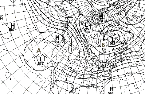
The chart at the left is an excellent example of a cut-off low. Low A off the California coast is equatorward of the main westerly flow that extends from the Gulf of Alaska into western Canada and then southeastward into the eastern United States. The cut-ff low is characterized by a cold core and slow movement. Cut-off lows can persist for days before being reabsorbed into the main westerly current. The areas off the Californias and in the Atlantic Ocean east of the Azores are favored regions for the formation of cut-off low centers.
Closed Contour Lows

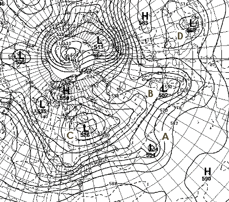
Closed contour systems that are embedded within the westerly current are called closed contour lows. These lows move with the westerly current and the closed contour may open or remain closed as the system changes intensity. On the chart at the right Low A and Low B are examples of closed contour lows.

Low C is also a closed contour low but is poleward of the main westerly current. It is associated with the long wave trough in the area. This type of low is often stationary but can migrate slowly in either an eastward or westward direction.

Low D is another closed contour low that is outside the main westerly flow. However, due to its location along a secondary track in the westerly flow, it is not classified as a cut-off low.
waves_closed.gif
Blocking
 

mohammadsadat

کاربر ويژه
ساخت بلندترین سد دو قوسی جهان(سد بختیاری) در لرستان آغاز شد

http://tasnimnews.com/Detail?id=36701

سلام سجاد جان:گل:
این وزارت نیرو دیگه شورشو درآورده و علی رغم هشدارهای پی در پی کارشناسای محیط زیست و منابع طبیعی هر جور دلشون بخواد پروژه ها رو تعریف میکنن
اگه دقت کرده باشی در جنوب شرق لرستان یه منطقه خالی شبیه به اونی که در غرب خرم آباده و در موردش صحبت کردیم، وجود داره که خیلی بزرگتره و قسمتی از استانهای اصفهان چهارمحال و خوزستان هم شاملشه. من همیشه از وجود چنین منطقه خالی ای در زاگرس خوشحال بودم و امید داشتم اونجا تبدیل به یه پارک ملی بزرگ و یه منبع درآمد پایدار واسه لرستان بشه.

یکی دو سال پیش جاده فرعی مسجد سلیمان بازفت شهرکرد تبدیل به جاده اصلی شد(در حالی که به گفته مردم همونجا اصلاً نیازی نبود و از همون مسیر اصلی ایذه نزدیکتر و بی خطرتره:سکوت:) و به این ترتیب جنوب شرق اون منطقه از بکری دراومد، حالا هم با احداث سد بختیاری در قلب اون منطقه خالی و احداث جاده دسترسی و رفتن مردم به اونجا دیگه خودت میدونی چه اتفاقی میفته
 

Amir Mohsen

متخصص بخش هواشناسی
[h=3]A Struggle for spring ,Is there any Hope?
Something just isn’t natural when Montana is warmer than portions of Florida come March 27th, or ever in that sense. So, why in the world has it been so cold and Spring has not shown its face? We are going to explain below.
Spring is arriving, slowly but surely. The average high temperatures have now risen into the lower fifties for many along I-95. However, Spring will be delayed this year (as you may have noticed before), as the cooler than normal temperatures continue from March into April, for at least the first half of the month of April. A brief warm up looks to commence around the turn from March into April, but this is short lived, as an impressive cold shot for April makes it’s way into the continental United States.
This cold shot is a product of a -EPO dip (a trough in the west coast promoting colder temperatures than normal) and a -NAO rebuilding once again (a blocking high pressure to the north), that is forcing a cold shot into the United States this week. We see in the image below that the -EPO and the -NAO are sure at work here. They are doing their dirty work on the temperatures throughout the atmosphere, and at 5,000 feet they are well below freezing for the majority of the United States. For a time, the -EPO will moderate, and allow a ridge to build in the West, ending their cold weather troubles temporarily. That still does not solve our problems in the Northeast!
There are also a few storm threats with this cold pattern that are showing up on the models. These need to be watched, as the threat for wintry weather for many may continue into even April. After this cold shot, a more sustained warm pattern looks to develop, but this sustained warm shot is continually getting pushed back on the models. Eventually, a sustained warmer than normal pattern will arrive, but it is difficult to define an exact date. We can only approximate when a good, long stretch of spring-like weather can come, after all it is Spring.
[h=3]Can the MJO bring us Warm Thoughts? Another good indication to see if we are going to climb out of this lingering winter pattern is the Madden Julian Oscillation (MJO). The MJO measures the strength and the position of tropical convection around the Equator and the International Date Line, which ultimately determines the positions of the troughs and ridges that govern the general state (warm, cold, settled, or unsettled).
Unfortunately, the MJO is looking to not be such a player from now until around two weeks in the future, as it is forecasted to be weak. We know this because the image shows the MJO Progression in the “Circle of Death”. The closer proximity to the center the modeled position is, the less influential the MJO is. With the MJO’s relaxed grip on the global pattern this gives more localized synoptic events to influence the pattern (low pressure systems, cold fronts etc…). Long range models are hinting at a warmer phase of the MJO re emerging during the second week of April, but given how far out in time it is, this will need to be readdressed in a future update.
Below, the team illustrates the little effect the MJO will have on the pattern (using the EURO MJO Forecast)
The latest models show a battle between high pressure that is trying to develop and consistent low pressure systems that constantly draw colder air down, squandering the effects if the ridge and weakening it.
Cold Air Firepower
The cold air does have some “firepower”. It has the backing of two teleconnections that will become a formidable opponent to any developing ridge. They are the North Atlantic Oscillation (NAO) and the Arctic Oscillation (AO).
North Atlantic Oscillation Explained
The North Atlantic Oscillation is a measure of a high pressure system’s location over Greenland and how much it backs up the atmosphere. If the NAO is positive, the atmosphere is free to swing system after system in a progressive fashion. No system has a dominant impact on the region for more than a few days. For you warm weather lovers that does not seem to be the case. The NAO is going to be negative. That means that the atmosphere will be blocked up due to that high pressure slowing the movement if the atmosphere to a slower rate than if the NAO was positive. This provides the chance to low pressure systems and troughs to hang around for a bit longer and establish a colder reign of our weather pattern. For the foreseeable future, the NAO is forecast to remain negative and provides the potential for a few more cold rain storms with perhaps a wintry hint to them.
Arctic Oscillation Explained
The other influential Teleconnection is the Arctic Oscillation. It is a measure of the amount of cold air that is available to descend into the Northeast and the Mid-Latitudes. That cold air can also be used for any low pressure and potentially support a rare April snow for some. When it is negative, cold air is available to or is already ******ed down to put the Northeast below average in the temperature department. Often times, a negative AO is accompanied by a trough, which increases the threat for precipitation.
Do they Remain Negative?
Latest models take the AO and NAO negative throughout the next two weeks, which promotes a general period of toughness and colder than normal weather. As soon as a ridge of high pressure tries to build in, there is another low pressure system that is quickly approaching.
A Graphical Summary
  1. The NAO will keep the low pressure systems blocked, and they are likely to impact the area, bringing repeated cold shots behind them.
  2. Ridges of high pressure (hints of a southeast ridge) are desperately trying to develop, but the progressive nature of the incoming low pressure systems is pushing the ridges out to sea before they can establish any warmer weather for the Northeast.
  3. The troughs are fueled by low pressure systems, which all look to situate themselves over the Northeast and result in below average temperatures.
In conclusion, expect colder than normal weather for the Northeast for the next two weeks, as the cold air has a chokehold on the region. Due to the three factors above.
We will explain if this is going to end in our spring outlook, which is coming this week. We will soon let you know when it is going to be released. Hint: A lot is going to have to occur to kick this cold spell out of the country.

 

mohamad_73

کاربر ويژه
تقریبا بیست میل بزای تهران و سی میل هم برای مشهد. برای سیستم بعد سیزده فروردین. هواشناسی انگلیس پیش بینی کرده

جالبه دمای تهران را اونموقع سه درجه زده!
ولی ای مپ ودر بارش دهم اوریل بود فک کنم پرونده و از شدت سرما هم کاسته
 

آرش-مشهد

کاربر ويژه
سلام دوستان آبدیت جدید نروژ و مدل ECM برای مشهد بارشای خیلی خوبی رو به همراه هوای سرد پیشبینی کردن. فقط از یه چیزی میترسم و اون گسترده نبودن بارشاست. مثلا همین نروژ تو آبدیت جدیدش بارش چناران رو تقریبا پرونده. برای قوچان هم حدود 4 میلیمتر برای سامانه اوایل هفته پیشبینی کرده. در ضمن GFS هم خدا رو شکر بارشا رو تو آبدیت جدیدش یکمی بهتر کرده.
 
وضعیت
موضوع بسته شده است.
بالا