-
توجه: در صورتی که از کاربران قدیمی ایران انجمن هستید و امکان ورود به سایت را ندارید، میتوانید با آیدی altin_admin@ در تلگرام تماس حاصل نمایید.
You are using an out of date browser. It may not display this or other websites correctly.
You should upgrade or use an alternative browser.
You should upgrade or use an alternative browser.
مباحث عمومی هواشناسی
- شروع کننده موضوع Amir Mohsen
- تاریخ شروع
- وضعیت
- موضوع بسته شده است.
Amir Mohsen
متخصص بخش هواشناسی
Speed and Directional Shear and Common Hodographs
There are four basic combinations of speed and directional shear that are commonly observed and produce severe weather. The combinations are consisted of two types of shear. Shear is simply the difference between two similar observations. In severe weather, we pay close attention to the “speed shear” and “directional shear” of a given atmospheric setup
Speed shear is the difference in wind speed that the atmosphere changes between two points, or heights. For example at the surface, the wind may be light at 3 knots, however at 900 Millibars, (2,500 feet in the atmosphere) the wind may be strong at 55 knots. Thus, the net change would be (55-3) to equal a speed shear value between the two layers to be 52 knots.
Directional shear is the change in wind direction between two points. In an example, at the surface the mean wind direction may be from the southwest, at 235 degrees. However at 2,500 feet it may be from the east at 90 degrees. To have a healthy severe thunderstorm, a finite combination of speed and directional shear must be present.
These will be explained in detail below:
1.) Weak Speed Shear – Weak Directional Shear
First, you are probably wondering “how do I read this thing?” Not to fear. Although intimidating, the hodograph is very easy to comprehend once you know how to read it.
The circular shape represents the 360 degrees that wind cal travel in. It is “sliced” into four main sections, each indicating North, East, South, or West.
(Note as these are just examples, no set orientation of the hodograph nor quantitative values of the degree measurements are given).
The small numbers, (1,2,3,4,5) are the measurements of the speed shear and the directional shear at given heights.
For example, “1″ may be read at 900 Millibars (2000 feet), and read (55kts @ 125 degrees).
The values (20, 40, 60, etc…) represent equal values of wind speeds for any degree of measured wind speed.
Figure 7: This figure shows the hodograph for weak speed shear – weak directional shear
We see that there is little speed or directional shear in the hodograph above, so lacking the two suggests that this setup will most likely produce a weak, short lived thunderstorm that will be of weak to moderate strength.2.) Strong Speed Shear – Weak Directional Shear
Figure 8: This figure shows the hodograph for strong speed shear – weak directional shear
In a situation where there is strong speed shear and weak directional shear, the thunderstorm certainly is being prevented from collapsing on itself. However, it is getting sheared apart by the strong winds from level to level. This setup produces short lived thunderstorms that are often not severe, and carry small hail as well as the threat for heavy rain.3.) Strong Speed Shear – Strong Directional Shear
Figure 9: This figure shows a hodograph for strong speed shear – strong directional shear
If you see this setup, watch out! This is a prime setup for dangerous supercells as well as tornadoes. The thunderstorm is well ventilated as well as a strong rotating mechanism defined by the strong directional shear. This setup also is the most likely to produce large hail, and damaging winds at the surface.
Amir Mohsen
متخصص بخش هواشناسی
امیدوارم که دوستان عزیز مطالبی روکه به زبان انگلیسی میذارم که در واقع زبان فراگیری آسان علم هست رو به دقت بخونند و به راحتی از کنارش گذر نکنند:گل:
خصوصا این مطلب بالا رو که در ارتباط با نقش سرعت ، وزش باد و تغییرات ناگهانی جهت وزش باد در ترازهای بالای جو که منجر به شکل گیری پدیده طوفان و رعد و برق میشه.
برای بررسی نمودار هودو گراف شما می تونید به لینک رادیو سوند شهرهایی که اطلاعاتشون به صورت روزمره منتشر میشه از طریق لینک زیر مراجعه کنید:
http://weather.uwyo.edu/upperair/sounding.html
92 ناهنجار
Banned
Amir Mohsen
متخصص بخش هواشناسی
Parcel - When we give mention to a parcel, all that we mean is a concentration of air. Think of the air inside of a balloon. Now, imagine that air but without the balloon’s skin. The air inside the balloon is the parcel of air.
Buoyancy and density - Buoyancy is everything in severe weather. It is important because air at a higher temperature is more buoyant and less dense. It can ascend through the atmosphere higher since it is lighter than colder air. Although this is a very drastic example, think of the warmer air as helium, and the colder air as oxygen. The less dense gas (helium) rises through the denser air (oxygen).
Lifted Condensation Level (LCL)
To start, a water vapor condenses when the temperature of the water vapor (or air parcel) matches a specific dewpoint. The Lifted Condensation Level (LCL) is the level in the atmosphere where a rising air parcel condensed, and forms the base of a cloud. The rising air cools at specific rates that are defined by several atmospheric parameters. They are called lapse rates. The steeper the lapse rate is, the faster the air parcel cools and condenses, and the lower the cloud base is. When there are steep low level lapse rates, the atmosphere is said to be unstable, and the cloud base forms closer to the ground. On the contrary, when the air parcel does not cool significantly with height, the atmosphere is stable, and there is an unfavorable environment for severe weather since the cloud base will be sufficiently higher than the low level lapse rates setup. The LCL is very important because one can estimate the instability of the low level atmosphere by just noting how close the cloud forms to the ground.
Convective Available Potential Energy (CAPE)
Don’t let the name scare you. Conceptually, CAPE is the amount of buoyant (or rising energy) that a parcel of air has. It is measured in Joules per Kilogram (J./Kg.), which is basically the amount of energy (given in Joules), per mass (kilogram) of air. If there is a lot of CAPE, an air parcel will rise faster through its environment and therefore create a bigger cloud as it is able to shoot higher up into the atmosphere before it loses its buoyant energy. If there is a low amount of CAPE, then the thunderstorm will not have a lot of energy and will be generally be smaller and weaker in size and intensity respectively.

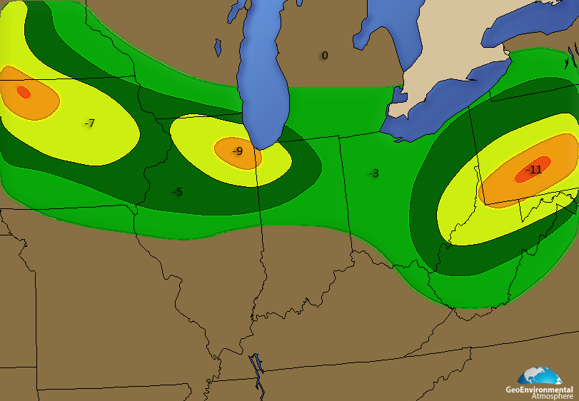
The Lifted Index is the temperature difference between the modeled temperature (produced by following various adiabatic lapse rates along the forecast soundings) and the actual (environmental) temperature. The bigger the difference (Ex. -10 C), the more unstable the atmosphere is. The warmer the rising parcel of the air (the more buoyant it is to its surroundings), the more unstable the atmosphere is.
Take the following example. At a specific air parcel rises, the modeled temperature says that its temperature should be at +10 C. It however, is at +17 C. The parcel then has more buoyant energy, and is able to rise farther up into the atmosphere than the colder air. It has a lifted index value of “-7”. (modeled temperature – environmental temperature). This is what is referred to as a negative lifted index value, and it a LI value of -7 would be supportive of strong to severe thunderstorms.
Helicity is the amount of corkscrew motion that the atmosphere produces. It is heavily influenced by the differences in the direction and magnitude of wind in the troposphere (this is assuming that speed shear favors severe weather). Simply, a large differential in the directions of winds in a very short distance will produce more helicity. High values of helicity will tend to aid in the rotation of the mesocyclones (rotating column of air in a thunderstorm). This concept will be explored more in-depth below.

Buoyancy and density - Buoyancy is everything in severe weather. It is important because air at a higher temperature is more buoyant and less dense. It can ascend through the atmosphere higher since it is lighter than colder air. Although this is a very drastic example, think of the warmer air as helium, and the colder air as oxygen. The less dense gas (helium) rises through the denser air (oxygen).
Lifted Condensation Level (LCL)
To start, a water vapor condenses when the temperature of the water vapor (or air parcel) matches a specific dewpoint. The Lifted Condensation Level (LCL) is the level in the atmosphere where a rising air parcel condensed, and forms the base of a cloud. The rising air cools at specific rates that are defined by several atmospheric parameters. They are called lapse rates. The steeper the lapse rate is, the faster the air parcel cools and condenses, and the lower the cloud base is. When there are steep low level lapse rates, the atmosphere is said to be unstable, and the cloud base forms closer to the ground. On the contrary, when the air parcel does not cool significantly with height, the atmosphere is stable, and there is an unfavorable environment for severe weather since the cloud base will be sufficiently higher than the low level lapse rates setup. The LCL is very important because one can estimate the instability of the low level atmosphere by just noting how close the cloud forms to the ground.
Convective Available Potential Energy (CAPE)
Don’t let the name scare you. Conceptually, CAPE is the amount of buoyant (or rising energy) that a parcel of air has. It is measured in Joules per Kilogram (J./Kg.), which is basically the amount of energy (given in Joules), per mass (kilogram) of air. If there is a lot of CAPE, an air parcel will rise faster through its environment and therefore create a bigger cloud as it is able to shoot higher up into the atmosphere before it loses its buoyant energy. If there is a low amount of CAPE, then the thunderstorm will not have a lot of energy and will be generally be smaller and weaker in size and intensity respectively.
Figure 4: In a series of figures below we start with this current figure which illustrates in color and value CAPE. The higher the CAPE value the better instability exists to produce severe thunderstorms. In this figure the best likelihood for severe storms would lie around 1200-1600 J/kg or 1600-2000+ J/kg.
Lifted Index (LI)The Lifted Index is the temperature difference between the modeled temperature (produced by following various adiabatic lapse rates along the forecast soundings) and the actual (environmental) temperature. The bigger the difference (Ex. -10 C), the more unstable the atmosphere is. The warmer the rising parcel of the air (the more buoyant it is to its surroundings), the more unstable the atmosphere is.
Take the following example. At a specific air parcel rises, the modeled temperature says that its temperature should be at +10 C. It however, is at +17 C. The parcel then has more buoyant energy, and is able to rise farther up into the atmosphere than the colder air. It has a lifted index value of “-7”. (modeled temperature – environmental temperature). This is what is referred to as a negative lifted index value, and it a LI value of -7 would be supportive of strong to severe thunderstorms.
Figure 5: Here we have placed lifted index values from (0) to negative values. As explained the the more negative the value presented the better chance for lift in the atmosphere, hence bettering for thunderstorm development. Note: Thunderstorms can approach cloud tops of well over 40,000 thousand feet and lift is a very important factor we must take into account.
HelicityHelicity is the amount of corkscrew motion that the atmosphere produces. It is heavily influenced by the differences in the direction and magnitude of wind in the troposphere (this is assuming that speed shear favors severe weather). Simply, a large differential in the directions of winds in a very short distance will produce more helicity. High values of helicity will tend to aid in the rotation of the mesocyclones (rotating column of air in a thunderstorm). This concept will be explored more in-depth below.
Figure 6: Helicity another major contributor to severe weather and especially tornadoes. Where the value is high we find the best shear and corkscrew motion to produce
92 ناهنجار
Banned
اینم رونمایی از بنده در لباس روستاییان :خجالت2:

سلام بر دوستان عزیز:گل:
سلام بر علی ، این مرد خوشتیپ و دلاور:احترام:
عکسهات خیلی (خععععلی) قشنگ بود
Amir Mohsen
متخصص بخش هواشناسی
دوستان لینک زیر رو در ارتباط با مطالبی که باید در ارتباط با پدیده طوفان و رعد و برق بدانیم رو در صفحه اول تالار هواشناسی قرار دادم. استدعا دارم در اسرع وقت این مطالب رو مطالعه کنید و اگه مطلبی به ذهن تون میرسه رو به این مبحث اضافه کنید:
Mohammad-rasht
کاربر ويژه
درود بر دوستان
امیدوارم به همه شما خوش گذشته باشه.
سیزده به در هوای گیلان عالی و دلپذیر خواهد بود.کاش مردم هم رعایت کنن و با طبیعت مهربان تر باشن.
امیدوارم به همه شما خوش گذشته باشه.
سیزده به در هوای گیلان عالی و دلپذیر خواهد بود.کاش مردم هم رعایت کنن و با طبیعت مهربان تر باشن.
Mohammad-rasht
کاربر ويژه
لندن تا دقایقی قبل گویا رگبار برف داشته!
زمستان اروپا امسال خیلی ادامه دار شده.
زمستان اروپا امسال خیلی ادامه دار شده.
Amir Mohsen
متخصص بخش هواشناسی
تو ایران فکر کنم شدید ترین طوفان و رعد و برق در اثر تغییر سرعت و جهت باد در ترازهای بالای جو ( SHEAR )مطابق شکل زیر رخ بده:
CASE 2: STRONG SPEED SHEAR, WEAK DIRECTIONAL SHEAR
This situation is often termed "unidirectional shear". The speed shear will allow the storm to move. The movement insures the storm will last longer than an airmass thunderstorm. Unidirectional shear often produces storms that form into lines (Mesoscale Convective Systems (MCS's)). Since the storm moves, outflow produces lift that enables new storms to grow on the storm's periphery. Over time, a line a storms result. These storms primarily produce small hail, weak tornadoes and heavy rain when they are associated with severe weather.
EXAMPLE HODOGRAPH SKETCH #2
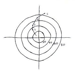
SKETCH 2: SE 19 knots @ 950 mb, SE 35 knots @ 850 mb, SSE 45 knots @ 700mb, S 70 knots @ 500 mb, SSW 85 knots @ 300 mb
ترنادوها و Super Thunderstorm های معروف آمریکا هم بر اساس الگوی زیر شکل میگیره:
CASE 2: STRONG SPEED SHEAR, WEAK DIRECTIONAL SHEAR
This situation is often termed "unidirectional shear". The speed shear will allow the storm to move. The movement insures the storm will last longer than an airmass thunderstorm. Unidirectional shear often produces storms that form into lines (Mesoscale Convective Systems (MCS's)). Since the storm moves, outflow produces lift that enables new storms to grow on the storm's periphery. Over time, a line a storms result. These storms primarily produce small hail, weak tornadoes and heavy rain when they are associated with severe weather.
EXAMPLE HODOGRAPH SKETCH #2

SKETCH 2: SE 19 knots @ 950 mb, SE 35 knots @ 850 mb, SSE 45 knots @ 700mb, S 70 knots @ 500 mb, SSW 85 knots @ 300 mb
CASE 4: STRONG SPEED SHEAR, STRONG DIRECTIONAL SHEAR
This situation can produce single-cell super-cells. This is the best situation in order to produce a rotating updraft. The speed shear enables the storm to move quickly and helps keep the updraft and downdraft separated while the directional shear helps rotate the updraft into the storm. These storms can produce large hail, strong tornadoes and heavy rain.
EXAMPLE HODOGRAPH SKETCH #3
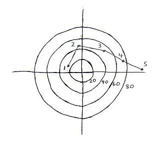
SKETCH 3: ESE 24 knots @ 950 mb, S 43 knots @ 850 mb, SW 52 knots @ 700mb, WSW 77 knots @ 500 mb, W 95 knots @ 300 mb
This situation can produce single-cell super-cells. This is the best situation in order to produce a rotating updraft. The speed shear enables the storm to move quickly and helps keep the updraft and downdraft separated while the directional shear helps rotate the updraft into the storm. These storms can produce large hail, strong tornadoes and heavy rain.
EXAMPLE HODOGRAPH SKETCH #3

SKETCH 3: ESE 24 knots @ 950 mb, S 43 knots @ 850 mb, SW 52 knots @ 700mb, WSW 77 knots @ 500 mb, W 95 knots @ 300 mb
Amir Mohsen
متخصص بخش هواشناسی
Amir Mohsen
متخصص بخش هواشناسی
Amir Mohsen
متخصص بخش هواشناسی
چرا ما یک همچین سایتی و نقشه هایی نداریم!!!!!!!!!!!!:تعجب2::ناراحت:
http://twister.sbs.ohio-state.edu/models
http://twister.sbs.ohio-state.edu/models
چرا ما یک همچین سایتی و نقشه هایی نداریم!!!!!!!!!!!!:تعجب2::ناراحت:
http://twister.sbs.ohio-state.edu/models
بهتره زمانی که من آنلاینم این سوال ها رو نکنی! و گرنه همون جواب های خوب خوبو میدم:نیش:
رودخانه فهلیان:این رودخانه که مهمترین رودخانه ی شهرستان ممسنی است ، ازبه هم پیوستن رودخانه ی شش پیرورودشیربه وجود آمده است که پس ازعبور ازکنارکوه قلعه سفید، وارد منطقه ی فهلیان میشود. این رودخانه پس ازمشروب ساختن اراضی وسیع، ازمیان دره ای عمیق به نام تنگ آبجان یا آبجونه می گذرد ودرناحیه ای به نام گوشه ی بردنگان بارودخانه کتی کور دروغزن یکی میشود .پس ازآن ، ازدره ای ژرف عبورمیکند ودرناحیه ی امام ضامن درغربی ترین ناحیه ی ممسنی به رودخانه ی پیظرین می پیوندد ورودخانه ی زهره را تشکیل میدهد. سپس به سوی جنوب امتداد یافته و مرزطبیعی بین ممسنی وناحیه گچساران را به وجود می آورد. همینک و با تقسیمات جدید کشوری و تبدیل شدن بخش رستم از توابع سابق ممسنی به شهرستان، پل فهلیان که بر روی رود فهلیان قرار دارد مرز طبیعی میان دو شهرستان محسوب میشود به نحوی که نصفی از آن متعلق به شهرستان رستم و نصف دیگر متعلق به شهرستان ممسنی میباشد.
تصاویر:

و

و

- وضعیت
- موضوع بسته شده است.


