• توجه: در صورتی که از کاربران قدیمی ایران انجمن هستید و امکان ورود به سایت را ندارید، میتوانید با آیدی altin_admin@ در تلگرام تماس حاصل نمایید.

مباحث عمومی هواشناسی

وضعیت
موضوع بسته شده است.

Amir Mohsen

متخصص بخش هواشناسی
[h=2]Washington D.C. Winter Outlook 2013-2014 Updated July 10, 2013 by Meteorologist Rob Guarino:گل:


Screen_Shot_2013-07-10_at_11.08.54_AM.png


dca_snow_extremes.png


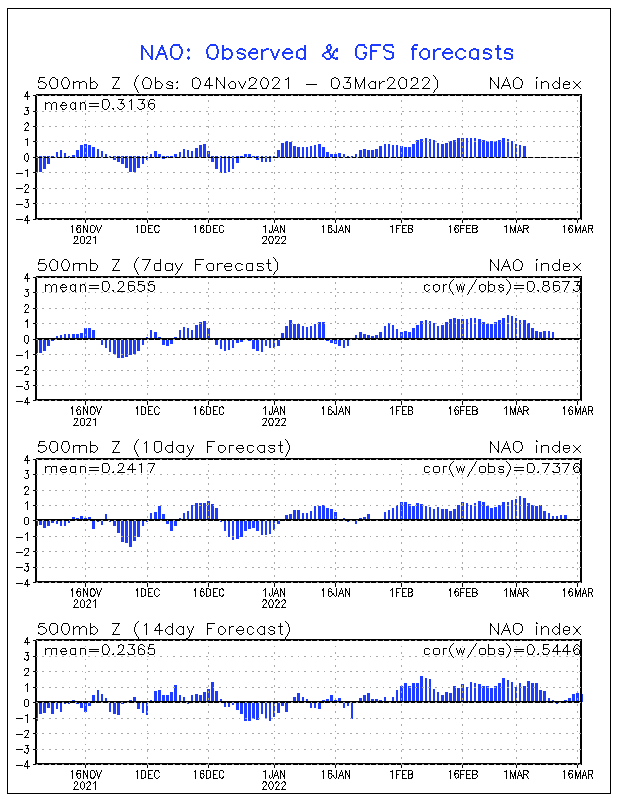
The NAO or North Atlantic Oscillation is simply a "blocking" pattern that allow for cold air to slow down and allows LOW pressure to form off the coast and have time to explode into snowstorms. It bascially is the traffic cop of weather. Slow the pattern down and the odds of a juiced up system getting into Baltimore increase.

The AO or Arctic Oscillation is like the traffic cop of Arctic Air and last winter the Arctic never got past the stop sign. This is a fickle index because to much Arctic air and all the storm get pushed south into the Carolinas..not enough and well you have what happen last winter. Put the NAO and AO in sync and a nice dose of moisture and you lean toward of the historic winter of 2009-2010.
----------------------------------------------------------------------------------------------------------------------------------------
HOW MUCH FOR WASHINGTON DC METRO ?
DC_SNOW.png
Screen_Shot_2013-07-10_at_11.22.23_AM.png


Amir Mohsen

متخصص بخش هواشناسی
[h=2]New York City Winter Outlook 2013-2014 July 6, 2013 Update by Meteorologist Rob Guarino

Share this


Screen_Shot_2013-07-01_at_3.50.50_PM.png
ao.jpg

Last Winter the cold stayed North This Winter we see shots of cold

nyc_snow_graph.jpg

nyc_central_park.jpg

Take a look at the snow decline the last 150 years. This is due to the growth in NYC as it becomes a bigger heat island and to a degree a climate change cycle we are in right now. You can also see on the light blue dots it's rare to go back to back winters under 10" at Central Park.
THE 2013-2014 NYC METRO WINTER OUTLOOK
El Nino will be a bigger factor this winter as will a few other features in Dec-Jan-February
1. NAO Index 60%
2. AO Index 30%
3. Snow Cover in Canada & USA 10%
Screen_Shot_2012-11-13_at_10.48.56_AM.png
Screen_Shot_2013-07-01_at_3.59.12_PM.png


Amir Mohsen

متخصص بخش هواشناسی
امیر محسن
یعنی نیویورکی ها معتقدند زمستون امسالشون می تر کونه ؟

نوید جان

آپدیت امروز پیش بینی فصلی برای زمستان امسال در آمریکا حکایت از وقوع النینو- فاز منفی نوسان اقیانوس اطلس شمالی و حتی مثبت شدن شاخص POD داره که این به معنی وقوع زمستان سرد و پر برف در نواحی شرقی و خصوصا جنوب شرقی آمریکا داره .
 

ali_kermanshah

کاربر ويژه


نوید جان

آپدیت امروز پیش بینی فصلی برای زمستان امسال در آمریکا حکایت از وقوع النینو- فاز منفی نوسان اقیانوس اطلس شمالی و حتی مثبت شدن شاخص POD داره که این به معنی وقوع زمستان سرد و پر برف در نواحی شرقی و خصوصا جنوب شرقی آمریکا داره .

از روی این میشه در مورد زمستان اروپا و خاورمیانه پیشبینی کرد ؟؟
النینو که فکر کنم معمولا باعث بارش بیشتر و سرمای کمتر نسبت به لانینا میشه
 

Amir Mohsen

متخصص بخش هواشناسی
حالا این یکی خیلی جالبه!!!!!!!!!!!!!


[h=2]Denver (Ski areas too) Winter Outlook 2013-2014 July 9, 2013 Update

Share this


[h=3]
Screen_Shot_2013-07-09_at_5.49.25_PM.png
[h=3]

El Niño and La Niña are part of a climate pattern called ENSO (El Niño Southern Oscillation) that occurs across the tropical Pacific Ocean on average every five years. El Niño is characterized by above average temperatures in the Pacific while La Niña refers to below average temperatures. In Colorado, El Nino years tend be wetter than average.
The summer monsoon is strengthened bringing more afternoon thunderstorms and in the winter, El Nino tends to bring above average snowfall to the southwest and central mountains but Denver and the Front Range can see below average snowfall. The effects of La Nina can vary widely across Colorado but typically drier conditions are observed during La Niña years.
So it's looking more and more like the Winter of the El Nino...but what does that mean for Denver and the Rocky Mountains ? El Nino can be a fickle run through the higher elevations of Colorado due to the track of a storm...how much moisture the storm packs... and will that moisture equate to BIG SNOWS in the Denver Metro Area.
Denver can a wide array of weather from winter to winter with days in the 70's and sunshine to full blown blizzards just a few hours later. The same has been said for entire winters the past 150 years.
big_snow_denver_FINAL.jpg
little_snow_denver_FINAL.jpg
Due to where Denver sits Colorado tends to get both the La Nina and El Nino storms tracks but both can bring a wide range of moisture. Denver does better with the El Nino track simply because the moisture source comes from the Deeper Warmer Waters of the Pacific Ocean.
EL_NINO_VS_LA_NINA_LARGE.jpg

EL_NINO_VS_LA_NINA_SMALL.jpg
Denver looks to do well this winter...I expect an active JET and at least 2-4 blockbuster storms. This means snowfall for Denver will ABOVE AVERAGE.

CLIMATOLOGY FOR DENVER METRO LAST 100 YEARS
Snw Days MonthInchesNotes
5.0January 7.0"temps swings
5.3February 5.7" snow base
5.8March10.7"surprise !
4.1April 6.8" late hitters
0.6May 1.1" rare events
0.5September 1.3" northern cold
1.8October 4.0"halloween
4.9November 8.7" common
5.3December 8.5" christmas !
33.3Year53.8" enjoy !


So this is kinda of a split forecast right now. I like the ski areas of Colorado and even Utah to have a decent ski season with above average snowfall but not a blockbuster snowfall this winter...just enough to make a good season not one of the great ones.

These are what I like to call the "BIG" 3. Thay all play off each other but the El Nino is like the GAS Gauge. The NAO (North Atlantic Oscillation) is a bigger factor for East Coast Snow but it can block or slow down a pattern across the USA and make for some back building snow in Denver and along the front range of the Rockies. Expect this to happen at least 2 this winter with that WILDCARD October big snow now possible...Can anyone say TRICK OR TREAT smell my snowy feet ?
The AO or Arctic Oscillation will bring just enough cold air this winter to make the Ski Regions of the Rockies happy and keep the skiers and boarders coming back for more !
So how does this all play out at this point for Denver ?
The ski areas of Colorado ?
Screen_Shot_2013-07-09_at_5.20.28_PM.png
Enjoy the outlook for snow and check back for updates and possible changes as we get closer to winter itself. A special "Hello" to my Aunt in Golden and cousins in Highlands Ranch. See ya this winter at the slopes ! NEXT UPDATE IN AUGUST.
 

Amir Mohsen

متخصص بخش هواشناسی
این نقشه جت استریم نیمکره شمالی امروز رو ببینید!!!!

تقریبا میشه دامنه نفوذ سرما رو در ماههای پیشرو حدودی حدس زد:

jetstream_norhem_00.gif
 

saeed hh

کاربر ويژه
از روی این میشه در مورد زمستان اروپا و خاورمیانه پیشبینی کرد ؟؟
النینو که فکر کنم معمولا باعث بارش بیشتر و سرمای کمتر نسبت به لانینا میشه

این فرضیه که فقط النینو و لانینا تو اب وهوای یک منطقه تاثیر دارند به کل رد شده!!
 

ali_kermanshah

کاربر ويژه
این فرضیه که فقط النینو و لانینا تو اب وهوای یک منطقه تاثیر دارند به کل رد شده!!

بله دوست عزیز این مطلب را میدونم

به طور مثال شاخص هایی مثل nao و ao هم بر آب و هوا منطقه ی ما تاثیر دارن و

تا اونجای که اطلاع دارم شاخص انسو در فصل پاییز بیشتر از زمستان تاثیر داره
 

saeed hh

کاربر ويژه
من امیدوارم اگه قرار هستش مثل دو سال گذشته پاییز پربارش و ناهنجار باشه و زمستون خشک بشه مثل پارسال نشه مثل دوسال قبل بشه ناهنجاری بارشی بیوفته روی جنوب البرز !!

البته امیدوارم همه جا روند عادی خودشونو بگذرونند!

  • :گل:

    هومن امدم:خنده1:


Amir Mohsen

متخصص بخش هواشناسی
با توجه به رفتار اینروزهای جت استریم اون چیزیکه فعلا از نقشه ها بر میاد بداینگونه است. حالا باید تا ماههای اینده صبر کنیم ببینیم شرایط چطور میشه|:

unto9d7bru8pbo02ifw5.jpg
 

ali_kermanshah

کاربر ويژه
دوستان

کسی در مورد لوازم جانبی جدیدی که برای گوشی ها و تبلت های هوشمند اندرویدی و اپل طراحی شده و شامل یک آنتن است و با کمک اون میشه یک استگاه هواشناسی ایجاد کرد اطلاعاتی داره ؟؟
 
وضعیت
موضوع بسته شده است.
بالا