• توجه: در صورتی که از کاربران قدیمی ایران انجمن هستید و امکان ورود به سایت را ندارید، میتوانید با آیدی altin_admin@ در تلگرام تماس حاصل نمایید.

مباحث عمومی هواشناسی

وضعیت
موضوع بسته شده است.

ali_kermanshah

کاربر ويژه
اگه جلگه منظورت باشه از نظر دمای و بارش تابستانه مثل اکثر نقاط سواحل شمالی هستش. تفاوت شرجی‌اش چندان چشمگیر نیست. اما دمای زمستانش اندکی بالاتره و برفش مثل سایر نقاط جلگه‌ای مازندران از جلگه‌ی گیلان کمتره. از سال 76 تا 86 در مازندران خصوصن مرکز و شرقش برف چندانی نباریده بود.

حالا اگر بخواهیم میزان بارش برف سالانه چند سال اخیر کرمانشاه و شهر نوشهر را مقایسه کنیم کدوم بیشتره ؟؟
 

ماهان.

کاربر ويژه
هوا امروز به نسبت سرد شده. دمای فعلی (ساعت 12) 18.1+‌ درجه‌ست که نسبت به دیروز در همین ساعت تغییر خاصی نکرده و نسبت به پریروز 6 درجه سردتر شده.
 

ماهان.

کاربر ويژه
حالا اگر بخواهیم میزان بارش برف سالانه چند سال اخیر کرمانشاه و شهر نوشهر را مقایسه کنیم کدوم بیشتره ؟؟

ای بابا علی جان شکست‌نفسی می‌کنیا. مظلوم‌تر از نوشهر گیر نیاوردی که با کرمانشاه مقایسه‌اش کنی؟ :D
مسلمه که برف کرمانشاه خیلی خیلی از نوشهر بیشتره!
 

ali_kermanshah

کاربر ويژه
ای بابا علی جان شکست‌نفسی می‌کنیا. مظلوم‌تر از نوشهر گیر نیاوردی که با کرمانشاه مقایسه‌اش کنی؟ :D
مسلمه که برف کرمانشاه خیلی خیلی از نوشهر بیشتره!

اخه ممکنه پاییز و زمستان آینده اونجا باشم برای همین داشتم یه حساب و کتابی می کردم :خجالت2:
 

navid-mashhad

کاربر ويژه
سمت هزار مسجد امروز هم تمام ابریه
دیروز که درگز و کلات ترکوندن !!

کلن این دو ایستگاه احتمالن بارش تابستانشون نسبتا قابل باشه اما آماری در دست نیست
ایستگاه سینوپتیک درگز 1386 و کلات 1388 تاسیس شدن
 

ماهان.

کاربر ويژه
اخه ممکنه پاییز و زمستان آینده اونجا باشم برای همین داشتم یه حساب و کتابی می کردم :خجالت2:

خب بارون زیاد می‌بینی. چالوس فکونم برفش یه خرده بیشتره. من دو سال دهه‌ی 70 رو چالوس بودم. برف‌های بهمن 72 و آذر 73 رو یادم می‌آد اونجا. هر دو بالای 30 سانت بودن. ولی الان خیلی کمتر برف می‌باره مازندران. اینطور که به نظر می‌آد از زمستون پارسال گیلان هم وارد فاز کم‌برفی شد!
 

navid-mashhad

کاربر ويژه
فاصله بین چالوس و نوشهر 5 متره:خنده2:
این دو تا باید با هم کنار بیان بشن 1 شهر

یک ویو خوب هم برای عکاسی از شهر داره
کمربندی نوشهر که تهش میشه کمربندی چالوس - از اون بالا نوشهر و چالوس و دریا دیده میشه
 

ali_kermanshah

کاربر ويژه
خب بارون زیاد می‌بینی. چالوس فکونم برفش یه خرده بیشتره. من دو سال دهه‌ی 70 رو چالوس بودم. برف‌های بهمن 72 و آذر 73 رو یادم می‌آد اونجا. هر دو بالای 30 سانت بودن. ولی الان خیلی کمتر برف می‌باره مازندران. اینطور که به نظر می‌آد از زمستون پارسال گیلان هم وارد فاز کم‌برفی شد!

فکر کنم اولین تغییری که اساس کنم شرجی بودن هوا باشه !! که البته به گرد و خاکی نبودن هوا می ارزه

البته کرمانشاه هم بعد از برف 40 سانتی دی 86 یه چند سالیه وارد فاز بی برفی شده !! :تعجب2:
 

ali_kermanshah

کاربر ويژه
محمد پور میگفت گردوغبار تو راه هستش با این گرما چه شود!!!

بله متاسفانه الان که نقشه های گرد و خاک را نگاه کردم 2 تا هسته گرد و خاک روی عراق در حال تشکیل شدن و حرکت به سمت ایرانه

هسته شمالی به سمت غرب و تا حدودی شمال غرب و هسته جنوبی هم به سمت جنوب غرب در حال حرکته !!!

http://oiswww.eumetsat.org/IPPS/html/MSG/RGB/DUST/EASTERNAFRICA/
 

Amir Mohsen

متخصص بخش هواشناسی
درود دوستان

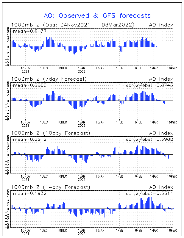
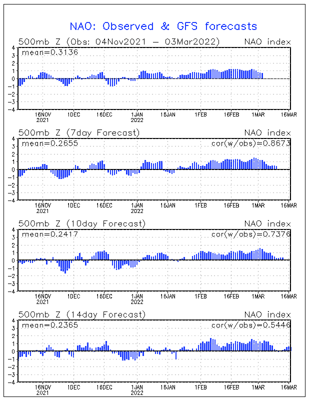
ظاهرا شاخصهای AO و NAO مجددا از 16 جولای به بعد روند مثبت شدن به خودش میگیره و این احتمال وجود داره از اون تاریخ به بعد ما شاهد آغاز دور جدید از بارش و کاهش دما در سطح کشور باشیم:


nao.mrf.gif


ao.mrf.gif
 

Amir Mohsen

متخصص بخش هواشناسی
چند تصویر برتر از آذرخش:

bay-bridge-lightning-120515.jpg


This gorgeous 20-second exposure of lightning striking the Bay Bridge in San Francisco went viral in April 2012.


Catatumbo-lightning-111118.jpg


Where Lightning Strikes Way More Than Twice


ig10_lightning_01_02.jpg

Bolt of LightningCredit: AP Photo/Mike MeadowsAutomobile lights seem to head in and out of a bolt of lightning in the northern Antelope Valley near Palmdale, California. The lightning ignited numerous small fires.


ig10_lightning_07_02.jpg


ig10_lightning_09_02.jpg


ig10_lightning_shuttle_02.jpg
 

hasan1

کاربر ويژه
سلام مجدد به همه دوستان

این هم عکسی از دمای قم دقایقی پیش :ناراحت:

g5z1t8vb4fejgxejetwb.jpg


اونوقت بگید هوای شهرتون گرمه!
 

Amir Mohsen

متخصص بخش هواشناسی
Massive Iceberg Breaks off Pine Island Glacier in Antarctica
  • Published: July 10th, 2013

repostus_bttn_shrt_embed.png


By Michael D. Lemonick
Follow @MLemonick
An enormous slab of ice, about a quarter the size of Rhode Island and some 200 feet thick, has broken away from Antarctica, according to German researchers.
The event, which was recorded by radar aboard Germany’s orbiting TerraSAR-X satellite, was not unexpected. In 2011, a NASA satellite noted that a huge crack had appeared in the ice shelf at the outlet of the frozen continent’s Pine Island Glacier. “At some point, it had to happen,” said Angelika Humbert, a glaciologist at the Alfred Wegener Institute in Bremerhaven, Germany, in an interview. “It’s a very normal process.”

www-climatecentral-org-images-uploads-gallery-PineIsland-GlacierCrack-1-650x425.jpg
www-climatecentral-org-images-uploads-gallery-PineIsland-GlacierCrack-2-650x425.jpg
www-climatecentral-org-images-uploads-gallery-PineIsland-GlacierCrack-3-650x425.jpg
www-climatecentral-org-images-uploads-gallery-PineIsland-GlacierCrack-4-650x425.jpg
www-climatecentral-org-images-uploads-gallery-PineIsland-GlacierCrack-5-650x425.jpg
www-climatecentral-org-images-uploads-gallery-PineIsland-GlacierCrack-6-650x425.jpg


  • www-climatecentral-org-images-uploads-gallery-PineIsland-GlacierCrack-1-100x65.jpg
  • www-climatecentral-org-images-uploads-gallery-PineIsland-GlacierCrack-2-100x65.jpg
  • www-climatecentral-org-images-uploads-gallery-PineIsland-GlacierCrack-3-100x65.jpg
  • www-climatecentral-org-images-uploads-gallery-PineIsland-GlacierCrack-4-100x65.jpg
  • www-climatecentral-org-images-uploads-gallery-PineIsland-GlacierCrack-5-100x65.jpg
  • www-climatecentral-org-images-uploads-gallery-PineIsland-GlacierCrack-6-100x65.jpg
Pine Island Glacier, July 8, 2013
Credit: DLR.


In fact, as Humbert noted, comparable calving events have happened here before —in 2001 and 2007 and “probably many times before that, although we didn’t have satellites in place to see it,” she said.
It’s not even the largest such event: a slab of ice nearly the size of Connecticut broke away from the Ross Ice Shelf in 2000, and floated around for a decade before it finally broke up. Strictly speaking, therefore, scientists can’t lay the blame for this breakup on global warming.
But global warming is clearly having a huge effect on the Pine Island Glacier itself, a massive river of ice that drains about 10 percent of the West Antarctic Ice Sheet.
This new iceberg won’t raise sea level at all, since it was already floating when it broke away. If the entire sheet were to melt or slide into the ocean, however, sea level would go up by 11 feet — and while that's not likely to happen soon, the combination rising air and water temperatures is destabilizing the ice, both from above and from below.
Of the two, melting from below could prove more problematic. Massive glaciers like the Pine Island grind their way downhill against underlying bedrock, and when they reach the sea, they keep grinding against the seafloor until the water becomes deep enough for the end to start floating.
The transition from grinding to floating is known as the grounding line, and as warm water eats at the ice from below, that line moves back toward the land. That means more floating and less grinding, and the reduced friction can allow the glacier itself to flow faster.
And in fact, Humbert said, “(The Pine Island Glacier) has been melting underneath the entire tongue of ice, and in particular close to the grounding line. “
At the same time, satellite observations have noted that the glacier has been accelerating in its flow to the sea.
The new iceberg, so big that it’s more properly described as an ice island — broke off more than 50 miles from the grounding line, and can’t be directly related to the melting happening there.
But that’s partly because scientists don’t fully understand glacier dynamics, said Humbert. Changes in the velocity of ice flow, she explained, can have effects on the entire glacier.
“You have a lot of stresses in there, which have an effect on calving,” she said. “We’re seeing a change in the entire system. We’re continuing to investigate what’s going on.”

 

ali_kermanshah

کاربر ويژه
یاد فیلم روز پس از فردا افتادم که داستانش با ترک خوردن یه کوه یخ بزرگ در قطب شمال شروع شد !!
 
آخرین ویرایش:

ماهان.

کاربر ويژه
فاصله بین چالوس و نوشهر 5 متره:خنده2:
این دو تا باید با هم کنار بیان بشن 1 شهر

یک ویو خوب هم برای عکاسی از شهر داره
کمربندی نوشهر که تهش میشه کمربندی چالوس - از اون بالا نوشهر و چالوس و دریا دیده میشه

ولی خب برف‌شون مقدار جزیی فرق داره. چون نوشهر شهر بندریه و چالوس از دریا چند کیلومتری دورتره. مثل مرکز شهر رشت و فرودگاه رشت. فرودگاه رشت 5 کیلومتر شمال شهره و به دریا نزدیک‌تره. اوایل آذر 90 که رشت 25 سانت برف باریده بود، توی فرودگاه فقط 1 سانت برف ثبت شد و بیشتر بارش بصورت بارون بود!!
 

mohamad$

کاربر ويژه

یعنی مثلا اقلیم مشهد مدیترانه با باران بهاره هست و سنندج که دماش همش بالای 40 میره کوهستانی سرده و تهران نیمه بیابانی سرد و ایلام نیمه بیابانی گرم با بارش سالانه 600 ؟:خنده1: میخوام ببینیم این نقشه ها رو کی طراحی میکنه:سوت:
 
وضعیت
موضوع بسته شده است.
بالا