
You are using an out of date browser. It may not display this or other websites correctly.
You should upgrade or use an alternative browser.
You should upgrade or use an alternative browser.
مباحث عمومی هواشناسی
- شروع کننده موضوع Amir Mohsen
- تاریخ شروع
- وضعیت
- موضوع بسته شده است.
Amir Mohsen
متخصص بخش هواشناسی
بنابر آخرین اطلاعات در بازه زمانی 11 الی 15 نوامبر طوفان برف در انتظار شرق آمریکا خواهد بود!
Amir Mohsen
متخصص بخش هواشناسی
.
And in the tropics, we officially have the most powerful tropical system globally for the entire year. It’s name is Haiyan, and it’s headed toward ~100 million people in the Philippines. Satellite estimations are showing winds around 175mph (with higher gusts) and a central pressure around 920mb as of Wednesday evening. This perfectly-formed tropical beast will make landfall in the central province of Leyte Friday. That’s the same area recovering from a deadly M7.1 earthquake that struck in October. Some slight weakening is expected, but it will still pack a dangerous punch upon landfall.
Super-Typhoon Haiyan Loop from CIMSS
Amir Mohsen
متخصص بخش هواشناسی
Now there’s some chatter about[HIGHLIGHT] snow next week[/HIGHLIGHT], and it’s not completely unfounded. Some models are oscillating back and forth with a potential storm that could cut across the northern Ohio Valley and toward the mid-Atlantic. And a few runs have also suggested a coastal storm for New England with yes, snow, even in a place like Boston. Before you run out and buy bread and eggs, I wouldn’t get too ramped up just yet.[HIGHLIGHT] Models tend to have greater error over longer time periods, and the confidence of next week’s setup is quite low. There is also limited blocking over the North Atlantic and the NAO will still be in a + phase during the storm timing. That would suggest a storm slipping out to our south more likely and then OTS. Take a look at a comparison of 12z models today. It tells the story of how all over the place solutions can be with a low-confidence pattern and a storm more than 7 days out. ECMWF – pretty much nothing. GFS – blockbuster[/HIGHLIGHT].
In any case we’ll be keeping an eye on it, and expect to hear some talk [HIGHLIGHT]about potential storminess for the next few days before we get a clearer picture.[/HIGHLIGHT] [HIGHLIGHT]The one thing that intrigues me most is that both the AO (Arctic Oscillation) and NAO (North Atlantic Oscillation) tank after the event next week.[/HIGHLIGHT] Typically, that would[HIGHLIGHT] suggest a lot of cold headed our way for the 2nd half of the month, and a November that when all is said and done is well below average.[/HIGHLIGHT] [HIGHLIGHT]Big events also tend to take place when teleconnections change dramatically. So even if we get nothing out of next week, chances are *something* large will happen, somewhere, mid-to-late November. Stay tuned[/HIGHLIGHT]!
In any case we’ll be keeping an eye on it, and expect to hear some talk [HIGHLIGHT]about potential storminess for the next few days before we get a clearer picture.[/HIGHLIGHT] [HIGHLIGHT]The one thing that intrigues me most is that both the AO (Arctic Oscillation) and NAO (North Atlantic Oscillation) tank after the event next week.[/HIGHLIGHT] Typically, that would[HIGHLIGHT] suggest a lot of cold headed our way for the 2nd half of the month, and a November that when all is said and done is well below average.[/HIGHLIGHT] [HIGHLIGHT]Big events also tend to take place when teleconnections change dramatically. So even if we get nothing out of next week, chances are *something* large will happen, somewhere, mid-to-late November. Stay tuned[/HIGHLIGHT]!
Amir Mohsen
متخصص بخش هواشناسی
اینهم یک عکس دیگه از طوفان فلیپین!!!!!!!!!!!!!!!!!!!!!!!
بدرود تا بعد
بدرود تا بعد
Amir Mohsen
متخصص بخش هواشناسی
باز مجبور شدم بیام
جی اف اس و نیروی دریایی در اقدامی کاملا زیبا ، آپدیت بینظیری کردند
جی اف اس و نیروی دریایی در اقدامی کاملا زیبا ، آپدیت بینظیری کردند
alirezamousavi
New member
کاش که یکبار هم شده از این طوفان ها در ایران اتفاق بیفته ایا میشه بهنظر شما؟
Amir Mohsen
متخصص بخش هواشناسی
کاش که یکبار هم شده از این طوفان ها در ایران اتفاق بیفته ایا میشه بهنظر شما؟
نه عزیز جان نمیشه
اونا وسط اقیانوسها و در مناطق استوایی رخ میدن ولی ایران در منطقه ای با آب و هوایی خشک و نسبتا بیابانی واقه شده!
بقول معروف ما کجا و اونا کجا
محمد بجنورد
کاربر ويژه
عجب آبدیتی کرد نیروی دریایی واسه ما!!
Amir Mohsen
متخصص بخش هواشناسی
بنظر میرسه از آخرین روزهای ماه دسامبر یعنی 27 دسامبر به بعد یک سامانه فعال وارد کشور میشه که بارشها غالبا به شکل برف هست و سامانه هسته سردی هم داره:
رباط کریم:
بقول دوست عزیزمون روستای نجف آباذ:
رباط کریم:
بقول دوست عزیزمون روستای نجف آباذ:
Amir Mohsen
متخصص بخش هواشناسی
خرم آباد:
Amir Mohsen
متخصص بخش هواشناسی
کاشمر:
Amir Mohsen
متخصص بخش هواشناسی
قزوین:
Amir Mohsen
متخصص بخش هواشناسی
متئوگرام سبزوار در ماه دسامبر پیشرو:
بد شانسی ما مشهد رو نداره!!!!!!!!!!!
بد شانسی ما مشهد رو نداره!!!!!!!!!!!
برترین تصاویر روز دنیا:
1 of 4
Rare solar eclipse
Credit: NASA/NOAA
On Nov. 3, the moon passed in front of the sun, blocking its light in a rare celestial event known as a hybrid solar eclipse. The hybrid eclipse began as an annular, or "ring of fire," eclipse along the path of totality, then shifted to a total eclipse, as the sun became fully obscured by the moon.
The celestial event, which was visible from eastern North America to the Middle East, was also spotted by the Suomi NPP satellite in orbit. The satellite snapped this image of the moon's shadow over the Gulf of Guinea, extending into western Africa. Three orbits of the Suomi NPP satellite are displayed in this image, each separated by approximately 97 minutes. [Related: The 7 Most Famous Solar Eclipses in History]

درود بر همه دوستان
تهران متاسفانه هوا بسیار آلوده و سنگین شده، باورش مشکله اما صبح هوا خیلی بهتر بود اما الان وضعیت جالب نیست!
هر بار که عکسی از خورشید گرفتگی میبینم، ناخودآگاه میرم به سال 1999 و آخرین گرفت قرن بیستم و 1 دقیقه و 33 ثانیه طلایی که در اصفهان شاهد گرفت خورشید بودم، به جرئت میتونم بگم هیچ چیزی در دنیا زیباتر از دیدن خورشید گرفتگی نیست، دیدن افق که با انواع رنگها نقاشی شده به همراه ستاره هائی که در وسط روز در آسمان قابل مشاهده میشن و در وسط این تابلو زیبا و جادوئی، خورشید رو میبینید که مثل همیشه نیست، یعنی شبیه هیچ چیزی که تا اون موقع در طول زندگیتون دیدید نیست!
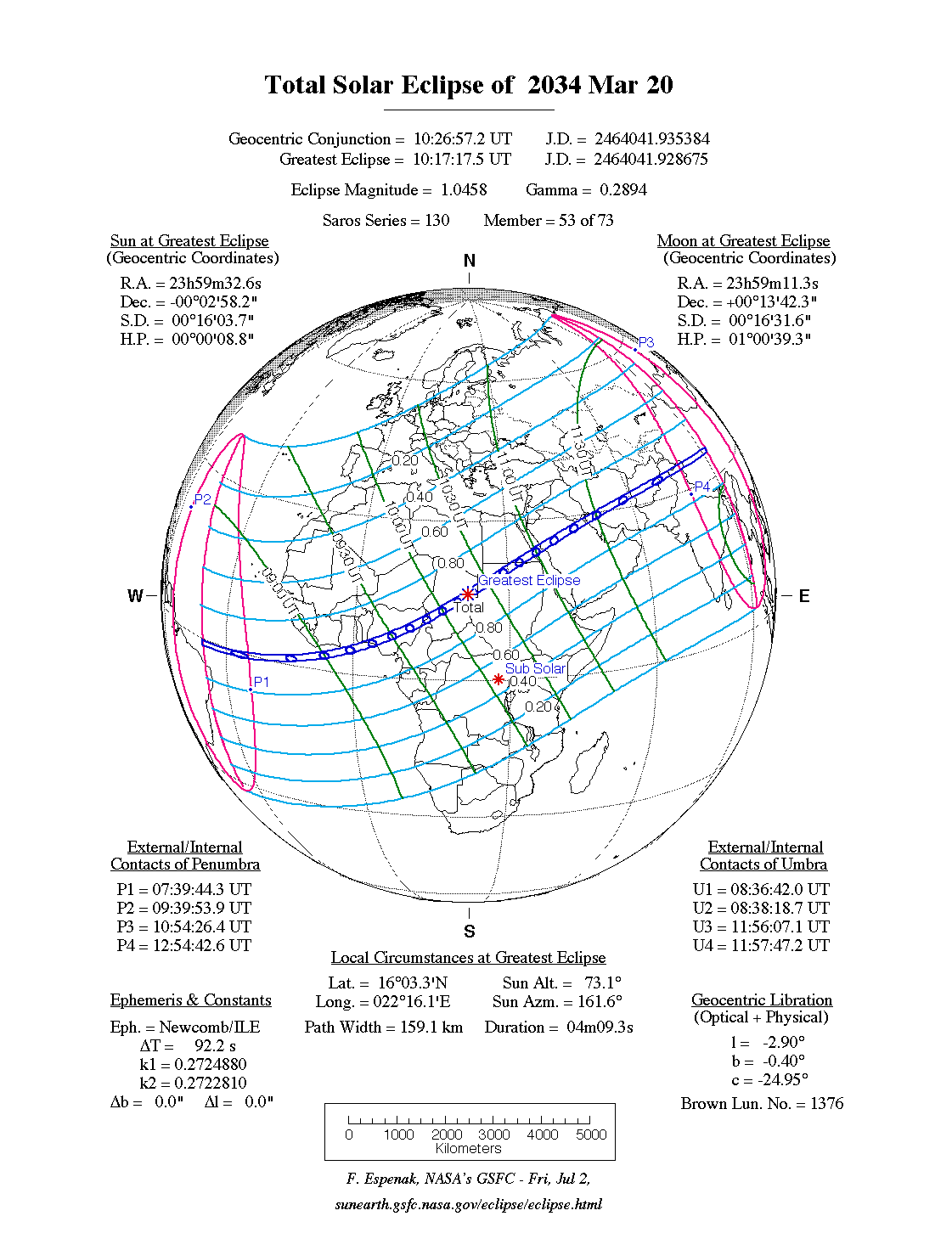
امیدوارم اونقدر عمر کنم تا گرفت روز دوشنبه 30 اسفند سال 1412 رو در کنار مقبره کوروش کبیر در شیراز رصد کنم.
نقشه گرفت آخرین روز سال 1412 هجری شمسی:
- وضعیت
- موضوع بسته شده است.