• توجه: در صورتی که از کاربران قدیمی ایران انجمن هستید و امکان ورود به سایت را ندارید، میتوانید با آیدی altin_admin@ در تلگرام تماس حاصل نمایید.

مباحث عمومی هواشناسی

وضعیت
موضوع بسته شده است.

Amir Mohsen

متخصص بخش هواشناسی

[h=2]3.6 Tropical Circulation and Precipitation Distribution The large-scale circulation features in the tropics affects the distribution of precipitation over tropical ocean basins and nearby continental regions. In general, the subtropical eastern ocean and nearby continent are dry. Moving westward, the subtropical ridge and trade wind inversion weaken, clouds grow taller, and precipitation intensity and amount increase as depicted schematically in Fig. 3.62. The major exception to this rule is the Indian Ocean where monsoon westerlies dominate.
precip_ocean.jpg

Fig. 3.62. Idealized distribution of precipitation influenced by the subtropical highs, ITCZ and trade wind inversion.
The wettest regions are found over the western tropical ocean basin, the result of pooling of warm surface waters driven by the trade winds. The warmest ocean is the tropical western Pacific, a region known as the Tropical Warm Pool. Heavy precipitation over nearby land results from evaporation from the warm ocean and water vapor being advected downstream. Moderately wet regions are found to the north and east of the very wet areas. Figure 3.63 confirms the conceptual pattern of precipitation and prevailing flow for the tropical Atlantic and Pacific during July and as well as the southeast Indian Ocean during January.
seasonal_mean_precipitation.jpg

Fig. 3.63. Seasonal mean precipitation (shaded, 925 hPa horizontal wind vectors, and 500 hPa geopotential heights (contoured every 10 dam) for (a) Jun-Aug and (b) Dec-Feb. Precipitation data from Xie and Arkin (1997) for the period 1979-1999; wind and geopotential height data from ERA-40 for the period 1962-2001. (from Chang et al. 2005)[SUP]35


اینهم لینک اصلی مطلب که بسیار مفید و آموزنده است:

http://www.goes-r.gov/users/comet/tropical/textbook_2nd_edition/navmenu.php_tab_4_page_6.0.0.htm

[/SUP]


Amir Mohsen

متخصص بخش هواشناسی
Key features of the WAM are the Sahara Heat Low, the cool SSTs and strong gradients of SST in the Gulf of Guinea, the Sahara Air layer (SAL), the ITCZ, and the mid-tropospheric African Easterly Jet (AEJ)[SUP]63,64[/SUP] (Fig. 3.48).
west_africa_atlantic_a.jpg
west_africa_atlantic_b.jpg

Fig. 3.48. (a) Major large-scale features and (b) key synoptic and mesoscale weather systems of the West Africa monsoon and the tropical Atlantic. The inset in (a) is a schematic of N-S vertical cross section along the Greenwich Meridian highlighting the heat low-AEJ-ITCZ system, the SAL (yellow shade), and meridional variations in the atmospheric boundary layer. (Adapted from Parker et al. 2005)[SUP]65[/SUP]
 

Amir Mohsen

متخصص بخش هواشناسی
sthp_winds_jan.jpg


sthp_winds_july.jpg


Fig. 3.14. Mean pressure systems and representative wind vectors at the surface for (a) January and (b) July. The red dashed lines represent the equatorial trough (and monsoon trough over Asia).
 

Amir Mohsen

متخصص بخش هواشناسی
mean_200hPa_wind_vectors.jpg
60 m s-1).">
Fig. 3.15. Mean wind vectors at 200 hPa in December-February (upper) and June- August (lower). Note stronger jetstreams in the winter hemisphere (orange > 60 m s[SUP]-1[/SUP]).
 

Amir Mohsen

متخصص بخش هواشناسی
هوا یه طور خاصی شده بنظر یا میخواد یک رگبار شدید برف بزنه یا اینکه به شدت سرد بشه

ولی به هرحال هوا نسبتا تاریک شده و باد سردی هم میوزه!
 

Amir Mohsen

متخصص بخش هواشناسی
اینجا هم دونه های برف هر از گاهی باریدن گرفتن و البته دونه های برف خیلی سنگین هستند و با سرعت زیادی به سمت زمین میان.
خدا رو شکر آسمون هم خیلی گرفته است:

meteogram_celcius.cgi
 

Amir Mohsen

متخصص بخش هواشناسی
دما سنج من دمای هوا رو 1.68+ سانیگراد نشون میده و فشار سطح دریا 1020 میلی بار - رطوبت 75 درصد
 

Amir Mohsen

متخصص بخش هواشناسی
اینجا هیچ خبری نیست ولی:

[h=4]Current weather observation
The report was made 17 minutes ago, at 13:25 UTC
Wind 7 km/h from south/southeast
Temperature 1°C
Humidity 93%
Pressure 1025 hPa
Visibility 1500 m
Broken clouds at a height of 305 m
Overcast at a height of 2438 m
light snow and mist
 

rainrain

New member
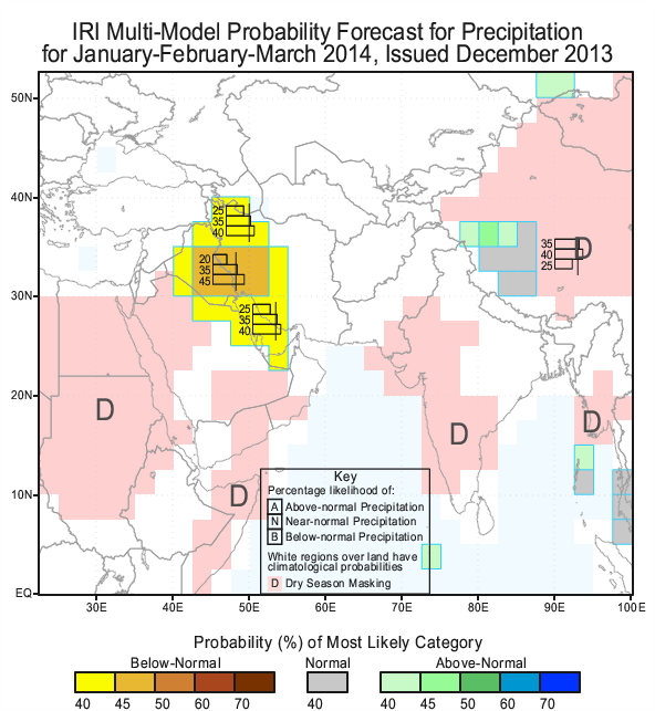
استاد امیر محسن عزیز چشم انداز بارش سه ماه زمستان برا کل کشور چطوره؟اخه پیش بینی هواشناسی کشور برا نیمه غربی کشور بارش زیر نرمال در نظر گرفته.

JFM14_MEa_pcp.gif
 
وضعیت
موضوع بسته شده است.
بالا