-
توجه: در صورتی که از کاربران قدیمی ایران انجمن هستید و امکان ورود به سایت را ندارید، میتوانید با آیدی altin_admin@ در تلگرام تماس حاصل نمایید.
You are using an out of date browser. It may not display this or other websites correctly.
You should upgrade or use an alternative browser.
You should upgrade or use an alternative browser.
مباحث عمومی هواشناسی
- شروع کننده موضوع Amir Mohsen
- تاریخ شروع
- وضعیت
- موضوع بسته شده است.
Amir Mohsen
متخصص بخش هواشناسی
آخرین وضعیت پوشش برف تا دیروز:

وضع خیلی جاها امسال خرابه !!!!!!!!!!!!
اروپا رو تا حالا تا این حد بدون برف دیده بودید!!!!!!!!!!!!!!!

وضع خیلی جاها امسال خرابه !!!!!!!!!!!!
اروپا رو تا حالا تا این حد بدون برف دیده بودید!!!!!!!!!!!!!!!
درود بر همگی
به نظر من باید بیشتر از اینکه ناراحت این شد که چرا بارش کم شد دنبال علت گشت.
اگه ما بدونیم برای چی مدل ها به یکباره این بارش رو کم کردند دفعه بعدی شاید خودمون قبل از آپ جدید مدل ها بتونیم حدس بزنیم!
امیر محسن جان نظر شما چیه؟ دمای انسو که تغییر چندانی نکرده. mjo هم که فکر نکنم باعث این تغییرات شدید شده باشه. آیا پای AO و NAO وسطه یا شاخص اسکاندیناوی یا چیز دیگه ای؟
آیا باز هم امکان بازگشت به اون حالت وجود داره؟
ببین امروز 13 ژانویه است و نقشه ها گرفتار نحسی 13 شدند :خنده1:
ولی یه چیزی بگم چشم انداز روشنه و ما که نگران نیستیم.
هر چی خدا بخواد همون میشه!
سلام.
آقا امیرمحسن آن روشنایی نیست آن سرابی از نور و روشنایی است.
بعد یادتون هست به شما گفته بودم این نقشه ها صد بار رنگ عوض می کنند و امسال سال نحس و افتضاحی برای شمالشرق است و قول هم می دهم تا آخر سال زراعی وضعیت همینطور پیش برود.:قاطی::کسل::75::گل:
Amir Mohsen
متخصص بخش هواشناسی
ما که بدون قندشکن هم دیدیم! :خنده1:
Amir Mohsen
متخصص بخش هواشناسی
لینکها و تصاویرش با قند شکن دیده میشه حسن عزیز
Amir Mohsen
متخصص بخش هواشناسی
As before we are currently seeing the lowest level of solar activity in terms of sunspots in the last 170 years. - See more at: http://notrickszone.com/2014/01/12/...-seen-such-a-weak-cycle/#sthash.xOBXBSQa.dpuf
Amir Mohsen
متخصص بخش هواشناسی
درود بر همگی
به نظر من باید بیشتر از اینکه ناراحت این شد که چرا بارش کم شد دنبال علت گشت.
اگه ما بدونیم برای چی مدل ها به یکباره این بارش رو کم کردند دفعه بعدی شاید خودمون قبل از آپ جدید مدل ها بتونیم حدس بزنیم!
امیر محسن جان نظر شما چیه؟ دمای انسو که تغییر چندانی نکرده. mjo هم که فکر نکنم باعث این تغییرات شدید شده باشه. آیا پای AO و NAO وسطه یا شاخص اسکاندیناوی یا چیز دیگه ای؟
آیا باز هم امکان بازگشت به اون حالت وجود داره؟
تحلیل شما چیه از این وضعیت حسن جان؟
Amir Mohsen
متخصص بخش هواشناسی
The Observatory ‘Polar Vortex’ That Caused Record Cold Is Related To Solar Activity, Not Man-Made CO2
Google translation + light editing, excerpt:
We summarize the claims of global warming promoters as: For the bitter cold in the United States, from the “Polar Vortex”, you can thank global warming, because the temperature increase, faster and more intense at polar latitudes (just north of the other) reducing the temperature differential along latitudes is slow and deflects the jet stream, which is a stream of strong winds aloft that separate the polar air from the middle latitudes. This slowdown and deviation may favor the persistence and intensity of events such as those of these days.
Well, the air movement from west to east, that is, along the latitude, is defined technically as zonal flow. The polar jet is its engine, and the track, and flows at about 9,000 meters above sea level in the area of contact between cold polar air and the temperate mid-latitudes. An area whose position oscillates also important in the short and medium time scale, for instance days or weeks, but that fluctuates much less if one analyzes over longer periods. Similarly, of course, varies the intensity of this stream, which, however, always in the long period, being generated neither more nor less than from differences in mass and temperatures, is much less variable. Unless, as writes Holthaus, there is half of the global warming.
…Before going, however, note with joy that the average generic catastrophism has decided to use a climate skeptic thesis, namely that an increase in temperature decreases the latitudinal gradient. Since all the weather events are generated by a gradient, namely, a temperature difference, a decrease should NOT increase intense events connected to it. But let’s get to the point. The one below is a chart that I asked him to prepare a Colarieti Carlo Tosti, the signature of our winter outlook ( here the last ). It is the zonal velocity (ie flow west-east) to the latitude and the altitude where it usually blows the polar jet over the whole circumference of the globe. The whole calculated for the entire period of data available on NOAA reanalysis, ie from 1948 to the present day. Data was superimposed on a curve that describes the trend, the period is about 60 years.
What we see now is:
This is an example, like many other similar pieces of literature of how poor assurgendo resist the role of ‘established facts’, simply because the contents continue to be cited by the professionals of the impending catastrophe.
- Date: 12/01/14
- The Hockey Schtick
Google translation + light editing, excerpt:
We summarize the claims of global warming promoters as: For the bitter cold in the United States, from the “Polar Vortex”, you can thank global warming, because the temperature increase, faster and more intense at polar latitudes (just north of the other) reducing the temperature differential along latitudes is slow and deflects the jet stream, which is a stream of strong winds aloft that separate the polar air from the middle latitudes. This slowdown and deviation may favor the persistence and intensity of events such as those of these days.
Well, the air movement from west to east, that is, along the latitude, is defined technically as zonal flow. The polar jet is its engine, and the track, and flows at about 9,000 meters above sea level in the area of contact between cold polar air and the temperate mid-latitudes. An area whose position oscillates also important in the short and medium time scale, for instance days or weeks, but that fluctuates much less if one analyzes over longer periods. Similarly, of course, varies the intensity of this stream, which, however, always in the long period, being generated neither more nor less than from differences in mass and temperatures, is much less variable. Unless, as writes Holthaus, there is half of the global warming.
…Before going, however, note with joy that the average generic catastrophism has decided to use a climate skeptic thesis, namely that an increase in temperature decreases the latitudinal gradient. Since all the weather events are generated by a gradient, namely, a temperature difference, a decrease should NOT increase intense events connected to it. But let’s get to the point. The one below is a chart that I asked him to prepare a Colarieti Carlo Tosti, the signature of our winter outlook ( here the last ). It is the zonal velocity (ie flow west-east) to the latitude and the altitude where it usually blows the polar jet over the whole circumference of the globe. The whole calculated for the entire period of data available on NOAA reanalysis, ie from 1948 to the present day. Data was superimposed on a curve that describes the trend, the period is about 60 years.
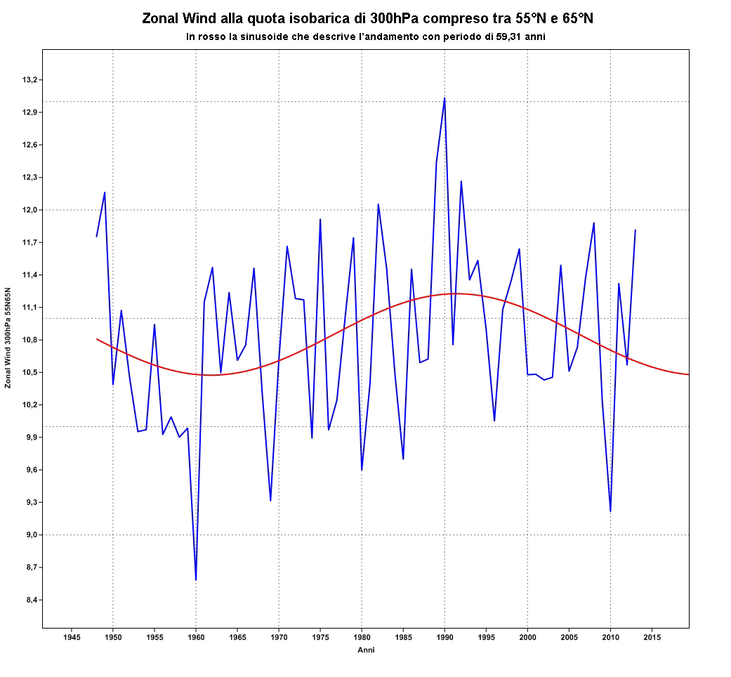
|
| Zonal flow over past 66 years shows the natural 60-year climate oscillation, with total absence of a long term trend. |
- a strong interannual variability;
- a total absence of trend;
- the minimum speed in the vicinity of vintages historically cold;
- the maximum speed in the historically warm years;
- speed lower on average in cold weather
- higher average speed during warm periods, always from the same dataset.
- period of about 60 years (also found in many other datasets of atmospheric parameters, including temperatures [and ocean oscillations]) coincident with that of the solar activity.
This is an example, like many other similar pieces of literature of how poor assurgendo resist the role of ‘established facts’, simply because the contents continue to be cited by the professionals of the impending catastrophe.
محمدرضا ...
New member
دوستان پیش بینی اکیوودر رو واسه سه شنبه چهارشنبه ببنید نظر بدین دیوونه شده پنجاه سانت برف
Amir Mohsen
متخصص بخش هواشناسی
A polar vortex, flooding and 50-degree heat: World is hit by extreme weather Monday 13 Jan 2014 6:00 am
Winter wonderland? Niagara Falls turned white in the recent cold weather (Picture: Reuters) Talking about the weather is as British as standing in a queue for too long or saying ‘sorry’ for something you haven’t done.
But even by British standards, there has been an awful lot of talk about the weather in the past few weeks. It’s difficult to find time to talk about anything else, given the recent storms and floods that have torn their way across the country.
Unfortunately, 2014 has brought tragedy and misery for many people who have lost loved ones or their homes. A number of people have been killed and thousands have had their homes flooded in the severe weather, as more than 100 flood warnings were put in place last week.
The devastation has led to calls for the government to do more to prevent the kind of flooding that is becoming a regular occurrence – it has pledged almost £400m a year to fight the problem, but some climate experts believe more needs to be spent on Britain’s flood defences.
But the conversation about weather has gone global in recent days, because it’s not only Britons who have suffered. In the US and Canada, more than 200m people were caught up in freezing conditions, believed to be caused by a polar vortex – a pattern of strong winds that has brought a mass of cold air. On just one day last week, the temperature in all 50 US states fell below freezing.
MORE: Polar vortex pictured from space
Another different weather extreme could be found in Australia, where temperatures rocketed to the 50C mark, just days after it was revealed that 2013 had been the hottest year in the nation’s history. In October, New South Wales was ravaged by a series of bushfires.
MORE: Cooked bat corpses falling from the sky in Australia
But are periods like the past week or so, filled with differing extreme weather patterns in different corners of the world, freak occurrences or the new norm?
‘The atmosphere globally is all connected, so we shouldn’t be entirely surprised if we get extreme weather in one place and another place at the same time,’ said Doug Parker, professor of meteorology from the school of earth and environment at the University of Leeds.
‘There is some evidence of global connections. The Australian heatwave is perhaps linked to what is happening to us. It’s like throwing a stone in the pond – if you’re having an event somewhere in the Earth’s atmosphere, then it causes waves to move out and they can move across the globe. If you have a big disturbance somewhere, like a storm, then that will cause changes in the atmosphere away from it and those changes move outwards around the world.’
Prof Parker pointed out that there is already a well-established link – another special relationship, almost – between weather systems Britain and in the US. The recent storms here have been caused by a jet stream crossing the Atlantic.
‘Our weather comes from that direction,’ he said. ‘You can get a seesaw effect across the North Atlantic – it’s called the North Atlantic oscillation. Quite often, if we’re getting one kind of weather, North America might be getting the opposite. That’s kind of what we’re seeing at the moment. They’ve had severely cold temperatures and we’re quite mild. Those temperature changes go hand in hand with the winds. In these conditions, the jet stream is pointing at us and firing these storms across us. They’re riding along the jet stream, effectively.’
Scientists cannot be definite on whether or not we are going to see more instances of severe weather like this in the near future, said Prof Parker, but when it does come, it will be hard-hitting.
‘One of the expectations with a warming climate is the storms that we get will be more intense, deliver more rain and have stronger winds,’ he said.
GALLERY: Polar vortex grips US and Canada
MORE: First floods then the snow for Britain
‘The big open questions are to do with the frequency of those storms and where they occur. We might get fewer of them or we might get more of them. One way of looking at climate change is to think that our climate will become more like those of warmer countries that we know.’
He said the public are beginning to ask the same questions about weather patterns as the scientists, and that they are becoming more interested in what exactly is happening in the atmosphere, illustrated by the recent interest in the polar vortex.
‘It’s a scientific term that we use a lot and the media have picked up on it – for some reason, it sounds kind of exciting,’ said Prof Parker. ‘Polar vortices are just one of those phenomena that move around.’
Although future weather events cannot be accurately predicted, there is a fear that fairly stable periods in Britain could be a thing of the past.
‘We seem to have had season after season of intense events,’ said Prof Parker. ‘We had some really cold winters a few years ago and we came from a period of drought in the UK into a period of really intense flooding – and that rainy season was record breaking. We don’t seem to have had a season that has been unremarkable for quite a long time.’
But he said there is still uncertainty about what exactly is behind the recent extreme weather around the world.
‘Scientists are wondering if this is just a roll of the dice. If you roll the dice a lot of times, occasionally you get three sixes in a row… or is it something where the dice is weighted by climate change?’
تحلیل شما چیه از این وضعیت حسن جان؟
راستش من خودم هم دارم از شما مطلب یاد میگیرم و سواد آنچنانی برای تحلیل نقشه ها ندارم.
ولی با توجه به اون چیزی که به نظرم میرسه نه شاخص انسو باعث این تغییرات شده و نه MJO
من احتمال بیشتر رو به تغییرات در شاخص های AO و NAO میدم. آیا استنباطم درسته؟
این وضعیت کنونی شاخص های AO و NAO
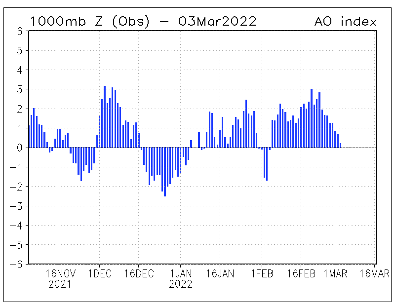
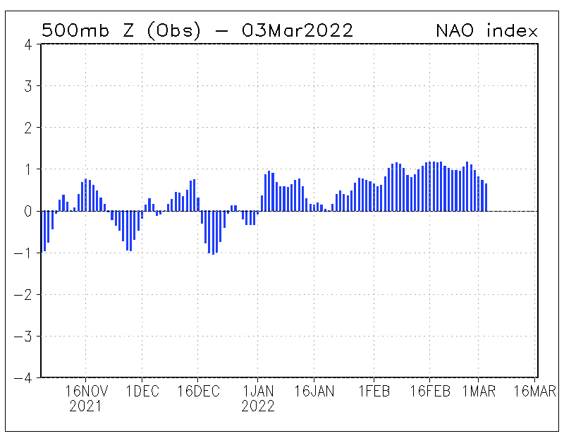
البته یه چیزی بگم از شما شنیده بودم که قبلا گفته بودید این شاخص ها در افت و خیز دمایی تاثیر دارند ولی در بارش تاثیر چندانی ندارند. پس دراینصورت این شاخص ها هم تقریبا میشه گفت نمیتونن تاثیر گذار باشند. پس چه عوامل دیگه ای میمونه واسه اثرگذاری؟


البته یه چیزی بگم از شما شنیده بودم که قبلا گفته بودید این شاخص ها در افت و خیز دمایی تاثیر دارند ولی در بارش تاثیر چندانی ندارند. پس دراینصورت این شاخص ها هم تقریبا میشه گفت نمیتونن تاثیر گذار باشند. پس چه عوامل دیگه ای میمونه واسه اثرگذاری؟
به تمام ایرانی ها درود
امسال کل ایران دارای بارش هست از اون سال هایی که زمستون معنا داشت سال 92 بود ایولا
بازم میگم امسال سال خیلی رویایی برای ایران هست
زمسون باید مثل 92 باشه برف همیشه بیاد در حد 3 سانت ولی ادامه دار باشه نه اینکه 40 سانت بیاد 40 روز بی بارش
خدایا شکر
امسال کل ایران دارای بارش هست از اون سال هایی که زمستون معنا داشت سال 92 بود ایولا
بازم میگم امسال سال خیلی رویایی برای ایران هست
زمسون باید مثل 92 باشه برف همیشه بیاد در حد 3 سانت ولی ادامه دار باشه نه اینکه 40 سانت بیاد 40 روز بی بارش
خدایا شکر
Amir Mohsen
متخصص بخش هواشناسی
راستش من خودم هم دارم از شما مطلب یاد میگیرم و سواد آنچنانی برای تحلیل نقشه ها ندارم.
ولی با توجه به اون چیزی که به نظرم میرسه نه شاخص انسو باعث این تغییرات شده و نه MJO
من احتمال بیشتر رو به تغییرات در شاخص های AO و NAO میدم. آیا استنباطم درسته؟
خواهش میکنم حسن جان شما استاد ما هستید.
ولی در مقوله بارش تاثیرات NAO و AO رو ازتون خواهش میکنم فراموش کنید . این دو شاخص بارها و بارها گفتم که تاثیر چندانی در بارش ما ندارند مثال میخواید :
زمستان و پاییز سال گذشته که ما در هر دو فاز مثبت و منفی این شاخصها بارشهای خوبی داشتیم
پس اگر اندکی تامل کنیم با توجه به تناقض این دو شاخص تاثیر آنچنانی به شکل بارش در گستره جغرافیایی اقلیمی ایران نباید متصور بشیم . مگر در برخی نقاط شمال غرب و یا تا حدی جنوب شرق!!!
این موضوع بارها و بارها در اینجا گفته شده ولی متاسفانه باز هم دائم مطر میشه.
- وضعیت
- موضوع بسته شده است.

