رشت مقدس در بهاری ترین فرمت

سلام و درود فراوان به جناب محمود. خوب و سلامت هستید؟
رشت مقدس در بهاری ترین فرمت
سلام و درود فراوان به جناب محمود. خوب و سلامت هستید؟
درود آرش جان
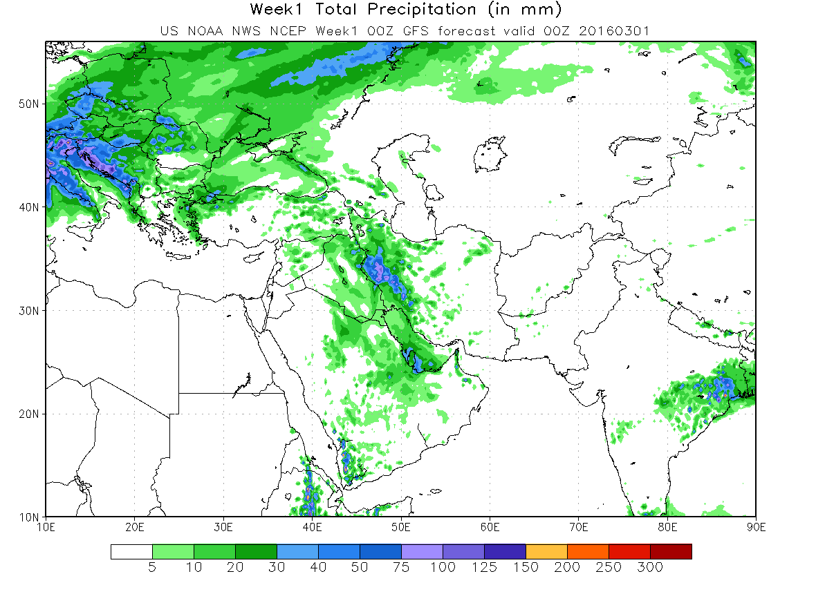
انشاء الله که اصفهان هم بارشیهای بسیار خوبی رو دشت کنه!
در ارتباط با سامانه 4 فوریه باید عرض کنم که دیشب یک مقاله بسیار مهمی گذاشتم و متاسفانه دوستان به اون مقاله توجهی نکردند!!!!!!
توصیه میکنم که این مقاله بسیار مهم رو به دقت بخونید و ترجمه کنید:
Stratospheric Phenomenon Is Bringing Frigid Cold to U.S
736 164 444 16
- Published: January 18th, 2013
By Andrew Freedman
Follow @afreedma
An unusual event playing out high in the atmosphere above the Arctic Circle is setting the stage for what could be weeks upon weeks of frigid cold across wide swaths of the U.S., having already helped to bring cold and snowy weather to parts of Europe.
Forecast high temperatures on Monday, Jan. 21, from the GFS computer model.
Click to enlarge the image. Credit: Weatherbell
This phenomenon, known as a “sudden stratospheric warming event,” started on Jan. 6, but is something that is just beginning to have an effect on weather patterns across North America and Europe.
While the physics behind sudden stratospheric warming events are complicated, their implications are not: such events are often harbingers of colder weather in North America and Eurasia. The ongoing event favors colder and possibly stormier weather for as long as four to eight weeks after the event, meaning that after a mild start to the winter, the rest of this month and February could bring the coldest weather of the winter season to parts of the U.S., along with a heightened chance of snow.
Sudden stratospheric warming events take place in about half of all Northern Hemisphere winters, and they have been occurring with increasing frequency during the past decade, possibly related to the loss of Arctic sea ice due to global warming. Arctic sea ice declined to its smallest extent on record in September 2012.
An Arctic cold front was sliding south from Canada on Friday, getting ready to clear customs at the border on Saturday and Sunday, bringing an icy chill to areas from the Plains states through the Mid-Atlantic by early next week, including what promises to be a chilly second inauguration for President Obama. Temperatures in Washington on Monday are expected to hover in the low 30s, only a touch milder than Obama’s first inauguration, when the temperature was 28°F.
Reinforcing shots of cold air are likely to affect the Upper Midwest, Great Plains and into the East throughout February, with some milder periods sandwiched in between.
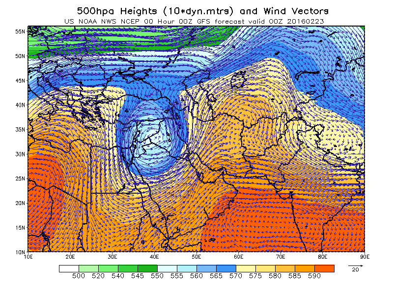
Sudden stratospheric warming events occur when large atmospheric waves, known as Rossby waves, extend beyond the troposphere where most weather occurs, and into the stratosphere. This vertical transport of energy can set a complex process into motion that leads to the breakdown of the high altitude cold low pressure area that typically spins above the North Pole during the winter, which is known as the polar vortex.
The polar vortex plays a major role in determining how much Arctic air spills southward toward the mid-latitudes. When there is a strong polar vortex, cold air tends to stay bottled up in the Arctic. However, when the vortex weakens or is disrupted, like a spinning top that suddenly starts wobbling, it can cause polar air masses to surge south, while the Arctic experiences milder-than-average temperatures.
During the ongoing stratospheric warming event, the polar vortex split in two, allowing polar air to spill out from the Arctic, as if a refrigerator door were suddenly opened.
An animation showing the evolution of the stratospheric warming event. The contours show absolute heights and the shading are height anomalies in the middle stratosphere, or about 16 miles above the surface. The height anomalies are a good proxy for temperature anomalies in the stratosphere with red representing high heights or warm temperatures and blue low heights or cold temperatures. You can see at the beginning of the loop a cohesive polar vortex along the coast of Northern Eurasia and then this area of higher heights or warm temperaturs rush poleward from Siberia into the polar vortex splitting it into two pieces, one over Eurasia and one over North America. The dramatic rise in heights or temperatures over the Pole is the sudden stratospheric warming. The result is that pieces of the polar vortex move equatorward and with it the associated cold temperatures. Usually something similar occurs in the troposphere in the ensuing weeks. Credit: AER/Justin Jones.
When the sudden stratospheric warming event began in early January, that signaled to weather forecasters that a cool down was more likely to occur by the end of the month, since it usually takes many days for developments in the stratosphere to affect weather in the troposphere, and vice versa.
“For reasons I don’t think we fully understand, the changes in the circulation that happen in the stratosphere [can] descend down all the way to the Earth’s surface,” said Judah Cohen, director of seasonal forecasting at Atmospheric and Environmental Research (AER) in Massachusetts.
As the polar stratosphere warms, high pressure builds over the Arctic, causing the polar jet stream to weaken. At the same time, the midlatitude jet stream strengthens, while also becoming wavier, with deeper troughs and ridges corresponding to more intense storms and high pressure areas. In fact, sudden stratospheric warming events even make so-called “blocked” weather patterns more likely to occur, which tilts the odds in favor of the development of winter storms in the U.S. and Europe.
Cohen was the lead author of a 2009 study that found that sudden stratospheric warming events are becoming more frequent, a trend that may be related to an increase in fall snow cover across Eurasia. The increase in snow cover has in turn been tied to the rapid loss of Arctic sea ice, since the increase in open water in the fall means that there is more atmospheric moisture available to fall as rain or snow.
Cohen and his colleagues at AER have been using an index of Eurasian snow cover during the month of October in order to make seasonal weather forecasts for the following winter, and he said that by using this technique, they successfully predicted the ongoing stratospheric warming event 30-days in advance.
“As far as I know this is a first and has huge implications for intraseasonal predictions,” he said.
Computer model forecast for February, showing widespread cooler than average conditions in much of the U.S.
Click to enlarge the image. Credit: Weatherbell.
Cohen’s research has also pointed to stratospheric warming events as one of the reasons why the second half of recent winters in the Northern Hemisphere have turned out to be colder than the first half.
“Scientists about a decade ago predicted that stratospheric warmings would become less frequent with climate change, however, just the opposite has happened and they have become more frequent. There is a positive trend in stratospheric warmings since the turn of the century and I have argued this is contributing to more severe winters,” he said.
When the vortex becomes dislodged from the pole, Cohen said, it can lead to a flow of air that is more north to south than west to east. “So when the warm air rushes the pole it displaces the cold air over the pole and forces it equatorward,” Cohen said.
This has major implications for U.S. winter weather.
High temperatures in North Dakota and Minnesota may not make it above zero Fahrenheit on Sunday and Monday. If Minneapolis records a high temperature below zero it will end its record-breaking streak of four years without such an occurrence. By Tuesday, the cold air will have spilled into Kentucky and Maryland as well as New England. And the long-range outlooks suggest that February is going to be a colder-than-average month from the Upper Midwest to the East Coast, although there may be brief breaks from the cold depending on the prevailing storm track.
Anthony Artusa, a seasonal climate forecaster at the National Oceanic and Atmospheric Administration (NOAA), said the cold air spilling southward for the inauguration may mark the beginning of a long-lasting cold period that is related to the stratospheric warming event. “It does look like this could be the early effects of it,” he said during a conference call with reporters on Thursday.
سلام بهراد جان خوبی؟ خیلی دلم براتون تنگ شده چه خبرا نیستی ؟
البته میدونم درگیر درسا و کارای پایان نامه و امتحان جامع هستی
از امیر مسعود خبری نداری؟؟
انشاا.... که موفق باشید و موید داداش بهزاد:گل:ممنون خوبم. امیدوارم شما هم سلامت باشید. به امید خدا از ترم آینده 2 تا کلاس ارشد دارم که برای تدریس باید مطالعه خیلی زیادی داشته باشم. من حدود 10 روز قبل با امیر مسعود تلفنی صحبت کردم درگیر درس و امتحان بودن.

با اين حساب بارش ها از 15 بهمن به بعد طبق مدل هاي فعلي از سر گرفته خواهند شد پس ديگه روياي برف براي پايتخت به سراب مبدل شد. در صورت بارش برف در نيمه دوم ماه با توجه به موقعيت زماني همانند دي هيچگاه نخواهد بود.
زمستان 91 در اذهان پايتخت نشينان به منفورترين و پست ترين زمستان تاريخ تهران مبدل شد.

با اين حساب بارش ها از 15 بهمن به بعد طبق مدل هاي فعلي از سر گرفته خواهند شد پس ديگه روياي برف براي پايتخت به سراب مبدل شد. در صورت بارش برف در نيمه دوم ماه با توجه به موقعيت زماني همانند دي هيچگاه نخواهد بود.
زمستان 91 در اذهان پايتخت نشينان به منفورترين و پست ترين زمستان تاريخ تهران مبدل شد.


لعنتی چنبره زده:|نرمال آرايش ارتفاع ژئوپتانسيل 500 ميلي بار
آرايش ارتفاع ژئوپتانسيل 500 ميلي بار در 19 ژانويه 2013
ناهنجاري
آرايش ارتفاع ژئوپتانسيل 500 ميلي بار در 19 ژانويه 2013