• توجه: در صورتی که از کاربران قدیمی ایران انجمن هستید و امکان ورود به سایت را ندارید، میتوانید با آیدی altin_admin@ در تلگرام تماس حاصل نمایید.

مباحث تخصصی هواشناسی و بررسی تاثیرات شاخصهای دور پیوندی و مولفه های اتمسفری در تابستان و پاییز و زمستان 1393

DR WHO

کاربر ويژه
A Super-Strong El Niño Is Now Off the Table. Here’s What That Means.
32
By Eric Holthaus
The world’s average temperature is breaking records, and India’s monsoon is in shambles. Borderline El Niño conditions are already here. How much worse will it get?


New data released Thursday by the International Research Institute for Climate and Society—a climate forecasting partnership between Columbia University and NOAA—shows that while ocean temperatures in the tropical Pacific are still above normal, the atmospheric response has so far been sluggish. After an impressive ramp up earlier this year, that means the coming El Niño is increasingly likely to fall a bit flat.


It’s a bit unusual for a building El Niño to dawdle as this one has. On Thursday, forecasters at the IRI scaled back forecasts a bit:


We have a 'holding pattern' on #ElNiño development, say Barnston. Probability a bit lower now than what we projected it to be last month.


— IRI (@climatesociety) July 17, 2014
What’s going on is relatively straightforward: El Niño is a phenomenon that occurs simultaneously in the ocean and atmosphere, usually initiated by a subsea sloshing of warm water toward the typically cooler Eastern Pacific. That part has already happened. Since the Pacific is so huge, the gradual emergence of a big swath of warmer-than-normal water during an El Niño eventually prompts something else: a reversal in the local trade winds, which can shift weather patterns worldwide. That’s the part we’re still waiting on. This process needs a reinforcing shot of westerly winds (counter the trade winds’ typical direction) to help dampen the cold water that normally springs up from deep below the ocean’s surface in the East Pacific. So far, the westerly winds have not come, and cold water is beginning to eat away at the burgeoning El Niño.


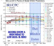
According to the IRI, the most likely scenario now is a weak-to-moderate El Niño:


While forecasts of strength still have uncertainty, we think a weak or moderate event more likely than a strong one, and more likely than no event at all. A weak event now appears just slightly more likely than a moderate one.
Multimodel ensemble showing #ElNiño development likely for August-September-October period. #IRIforecast pic.twitter.com/2FqbrEFyqG


— IRI (@climatesociety) July 17, 2014
The Australian Bureau of Meteorology—which like the United States hasn’t yet declared official El Niño conditions—was even more blunt in its update (PDF) earlier this week: “If an El Niño were to occur, it is increasingly unlikely to be a strong event.”


Just because a moderate-to-strong El Niño event is now less likely than a few months ago doesn’t necessarily change its expected impacts, however. Among the clearest climate signal for the second half of the year? An especially confident outlook for drought in Indonesia:


Expected climate impacts, even with weakened #ElNiño signal, haven’t really changed. #Indonesia #IRIForecast pic.twitter.com/RNxZu2MCAQ


— IRI (@climatesociety) July 17, 2014
Though rainfall across Southeast Asia has been roughly average in recent months, there’s evidence that El Niño will tip the scale toward drought. If a big drought does occur, it could have profound and lingering consequences worldwide. Large-scale Indonesian forest fires linked to the huge 1997-1998 El Niño released the equivalent of about one-quarter of the world’s human-caused carbon emissions that year. A recent study found Indonesia has now surpassed Brazil as the epicenter of global deforestation, thanks in part to the explosion of palm oil plantations there.


Another interesting development in India is that the Indian Ocean Dipole—a periodic oscillation of ocean temperatures that influences the important monsoon circulation—is moving in the opposite direction of a typical El Niño years, increasing the odds of a poor rainy season there. On Thursday, the Indian Meteorology Department announced (PDF) that monsoon rains had finally reached the entire country, though cumulative rainfall is still running a whopping 37 percent below normal.


Meanwhile, in California, new data on Thursday showed the state’s epic drought has continued to worsen. More than 80 percent of California is now classified as under “extreme” or “exceptional” drought. The prospect of a weaker El Niño bodes poorly for heavy drought-busting rains along the West Coast this winter.
 

Amir Mohsen

متخصص بخش هواشناسی
July Climate Briefing: El Niño Still Not Fully Developed Posted by Justin Grieser on July 18, 2014
From the July climate briefing, given by IRI’s Chief Forecaster Tony Barnston:
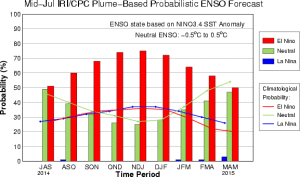
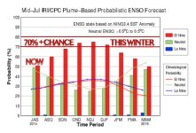
[h=3]Tony Barnston provides an overview of the briefing [h=3]Changes from last month’s briefing The latest model runs have reduced the chance of an El Niño developing by late summer in the Northern Hemisphere. The probability of an El Niño forming during the current July-September season is slightly above 50%, down from about 65% a month ago.
The IRI/CPC probabilistic ENSO forecast issued mid-July 2014. Note that bars indicate likelihood of El Niño occurring, not its potential strength. Unlike the official ENSO forecast issued at the beginning of each month, IRI and CPC issue this updated forecast based solely on model outputs. The official forecast, available at http://1.usa.gov/1j9gA8b, incorporates human judgement.

The reason for this reduction is that the above-normal sea surface temperature (SST) pattern in the tropical Pacific has weakened slightly since June. “About a month ago, the SST anomalies both near the International Date Line and off the coast of South America were stronger,” explained IRI Chief Forecaster Tony Barnston. Last week, the Niño3.4 sea surface temperature anomaly was +0.3ºC, down from +0.4ºC in early June.
While the current +0.3ºC anomaly indicates neutral ENSO conditions, model forecasts still predict a 75% chance of an El Niño developing by late autumn in the Northern Hemisphere. These probabilities are a slight decrease from IRI’s June forecast and slightly lower than the joint NOAA Climate Prediction Center/IRI forecast issued on July 10.
[h=3]Could an El Niño still develop? Despite the stalling sea surface temperature pattern in the tropical Pacific, several of the best climate models still expect a weak to moderate El Niño to develop later in 2014. “We still have an accumulation of positive heat content in the central and eastern tropical Pacific, which should eventually lead to more warming at the surface,” Barnston explained during the briefing.
The atmospheric pattern over the tropical Pacific, however, continues to resemble ENSO-neutral conditions. Since late spring, westerly wind bursts near Indonesia – which help push the warm waters of the western Pacific eastward toward South America – have become weak to non-existent. Until the atmosphere responds, an El Niño will be slow to develop over the coming months. Barnston therefore believes a weak El Niño is just slightly more likely than a moderate one.
[h=3]Effects of El Niño on global seasonal forecasts Each month, IRI issues seasonal climate forecasts for the entire globe. These forecasts take into account the latest ENSO projections and indicate which areas are more likely to see above or below normal temperatures and rainfall.
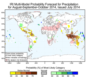
Although an El Niño has yet to develop, the climate impacts are still expected to resemble those of a weak to moderate El Niño. For the upcoming August-October period (image right), the forecast continues to show a strong likelihood of drier than normal conditions over Indonesia, and a 40% chance of below-average rainfall over western India. Wetter than average conditions are still expected over southeastern South America later this year, while northern South America shows a moderate tilt of the odds toward below-normal rainfall.
Scientists should know more each month about the chances for El Niño, its potential strength, and the climate impacts. Sign up here to get notified when the next forecast is issued, and in the meantime, check out #IRIforecast or use #ENSOQandA on Twitter to ask your El Niño questions.
 

Amir Mohsen

متخصص بخش هواشناسی
سلام

النینو نمرده است و مدلهای پیش بینی حکایت از گرم شدن دمای آب در ناحیه نینو 3.4 در پاییز 2014 دارند!

در اقیانوس آرام امواجی وجود دارند که در حال حاضر النینو رو پنهان کرده اند! سر در گم و نگران نباشید با حرکت شرق سوی افقی و تدریجی این امواج سرانجام در پاییز پیشرو تجمع آبهای گرم از پهنه غربی اقیانوس به سمت شرق این اقیانوس به حرکت در خواهند آمد و دمای آب در ناحیه نینو 3.4 افزایش خواهد یافت و النینو بوقوع خواهد پیوست!


به این امواج ، امواج کلوبن میگویند!

امواج کلوین دارای دو فاز میباشند:

1- downwelling

2-upwelling

در فاز شماره یک تجمع آبهای گرم در غرب اقیانوس آرام به تدریج به سمت شرق اقیانوس حرکت خواهد کرد.downwelling

فاز شماره 2- در این فاز آبهای سرد زیر سطحی اقیانوس آرام به سمت سطح و شرق اقیانوس آرام پمپاژ میشود و منجر به سرد شدن دمای آب نینو 3.4 میشود ما در حال حاضر در فاز شماره 2 قرار داریم ( upwelling):

مشاهده پیوست 57585
چشم انداز النینوی پیشرو:


مشاهده پیوست 57584
 
آخرین ویرایش:

DR WHO

کاربر ويژه
With each monsoon season India waits with bated breath for forecasts from the India Meteorological Department and other international forecasting agencies. This year’s forecast suggested a weakened monsoon, and sure enough for five weeks the monsoon has failed to provide the deluge that is expected.


For India, the monsoon rains typically last from June to September and contribute a whopping 80% of the annual rainfall total. Indian society is therefore finely tuned to the monsoon for its agriculture, industry and water supply for drinking and sanitation. If spread evenly over the whole country, the total rainfall during summer amounts to around 850mm. This year has seen a substantial deficit so far, currently standing at about 37% below normal and close to the large deficit in experienced in 2009, which was, like 2002 before it, a year of substantial drought, bringing reduced crop yields and hitting the country’s whole economy.


Now in mid-July, the forecast looks set to improve. The monsoons' advance northwards across the country has been particularly slow, leading to lack of water for agriculture and prolonged heatwave conditions – in Delhi a week or so ago I experienced temperatures near 40°C due to the absence of rain. In some regions, farmers have had to plant alternative crops that require less water due to the lack of rain, and authorities have diverted irrigation to drinking water, exacerbating their problems.


Anatomy of the monsoon


The monsoons are the biggest manifestation of the effects of the annual seasonal cycle on the planet’s weather. During spring and summer, the difference between the rapid warming of the Earth’s surface and the slower warming of the nearby ocean generates a tropospheric temperature gradient – a strong gradient in air temperature from north to south of the equator, seen in South Asia most strongly over northern India and the Tibetan Plateau. This temperature gradient stretches far up into the atmosphere forming a difference in pressure, stretching from high pressure over the southern Indian Ocean to low pressure over India. The result of this pressure gradient is the seasonal winds we know as the monsoon, which carry moisture to supply the monsoon rains across Asia.


Storm clouds coming. PlaneMad, CC BY-SA
The onset of the monsoon rains typically comes at the beginning of June, with the weather front stretching from the southwest Indian state of Kerala across the ocean to cover the states in the far northeast of India. For Indian society, and especially farmers, knowing about any variation in the intensity and duration of the monsoon and when it will start is vital. The progression of the monsoon across the country normally takes around six weeks, reaching the border of India and Pakistan by around mid-July. In September, the monsoon withdraws in the opposite direction, and as a result northwest regions experience a much shorter monsoon season and consequently greater pressure on water resources.


Change is coming


So why has it been happening? While a full study won’t be carried out until after the season, it is likely that it relates to El Niño – a warming of the central-to-east Pacific Ocean along the equator that happens every few years, changing seasonal weather patterns in many parts of the world but particularly around Indian and Pacific Ocean regions.


For India, El Niño is generally associated with monsoon drought. The remote interaction with the monsoon (known as teleconnection) is caused by a disruption to the normal trade winds in the Pacific and Indian Oceans, known as the Walker Circulation after Sir Gilbert Walker, a British meteorologist in India who sought to predict when the monsoon would fail.


Rising air and enhanced rainfall meet over the warm ocean surface during El Niño, much further east than Indonesia as is usual. But what goes up must come down, and these shifts in the circulation lead to descending air over India, which reduces the strength of the monsoon. Research has also established that El Niño can delay the monsoon’s onset, shortening the duration of rains over India.


A major concern is that the monsoon will be changed by global warming. However, all the indications from our climate models are that the Indian monsoon will continue to supply the region with strong seasonal rainfall. In fact most suggest that greater concentrations of atmospheric carbon dioxide will bring more, rather than less, rain. So far, so good – but the monsoon’s rains are not a statistical average spread equally on each day and in each location. Model simulations also suggest that tropical rainfall will tend to be heavier when it occurs, with potentially longer dry periods between rain events. Both of these factors have important implications for water resources, including crop damage as well as increased flooding.


With El Niño conditions forecast to grow in the Pacific throughout the rest of 2014, the full impact on this summer’s monsoon will depend on if the forecast comes true and the location of where El Niño occurs. What we can’t yet say with any certainty is how El Niño’s link to and effect on the monsoon will change under warmer future climate conditions – we only know that greater extremes of variability are likely, and a more variable monsoon may be a problem.
 

DR WHO

کاربر ويژه
رویداد النینو ونوسان جنوبی یکی از مهمترین وشاخص ترین رویدادهایی است که منجر به ظهور ناهنجاریهای بزرگ آب وهوایی در بسیاری از نقاط جهان می شود واین مساله ارتباطات ازراه دور شناخته شده است . پدیده نوسان جنوبی برای اولین بار توسط والکر درسال1923 ارائه گردید. گردش والکر،گردش اتمسفری،درصفحه ای عمود براستوا می باشد که باصعود هوا درشرق ارام استوایی شکل می گیرد وهمراه با آن دمای سطحی شرقی وبادهای غربی فوقانی به موازات استوا درسطح وسیعی از حوزه ارام استوایی ایجاد می شود .درواقع گردش والکر واکنش اتمسفر به گرادیان دمای سطح دریا درطول استوا ،میان دماهای پایین درشرق ارام استوایی می باشد وقویا در ارتباط با رویداد انسو است. درشرایط عادی منطقه،در غرب ارام حاره ای به واسطه با دمای تجارتی جنوب شرقی نسبتا ارام،گرمایش حاصل تشعشع خورشیدی موجب گرم شدن ابهای اقیانوس می شود. به طور همزمان با دمای تجارتی جنوب شرقی موجب فرارفت ابهای گرم به سمت غرب می شوند . بنابراین در غرب ارام حاره ای یک انباشتگی از ابهایی بادماهای بالا به وجود می اید وتراز دریا دراین منطقه بالاست . حال به دلیل تنش باد شرقی درارام استوایی حرکتی به سمت قطب درلایه اکمن اقیانوسی ایجاد می شود ودرطی آن به دلیل پیوستگی ،فراجهندگی آب سرد درنواحی مرکزی شرقی آرام استوایی به وجود می آید که این علتی بروجود زبانه آب خنک در نواحی مرکزی و شرقی آرام استوایی می باشد. بدین ترتیب در شرایط عادی منطقه درغرب ارام استوایی آبهای سطحی با دمای بالا ودرمرکز شرق آرام استوایی زبانه ای از آبهای سطحی بادمای پایین وجود دارد. بنابراین در شرق آرام استوایی پر فشار سطحی و در غرب آرام استوایی کم فشار سطحی شکل می گیرد و به دلیل گرادیان فشار به وجود امده ،حرکتی از شرق به غرب در سطح و به موازات استوا ایجاد شده و بدین سان گردش والکر که ماحصل گرمایش ادیاباتیک در نواحی استوایی است، شکل گرفته است و گاهی این گردش حاکم بر گردش هادلی در منطقه می شود. همراه با بادهای تجارتی جنوب شرقی قوی، گردش والکر شدت یابد اما قدرت گردش والکر با دمای سطح دریا در شرق آرام استوایی نیز در ارتباط است. به این ترتیب زمانیکه دماهای سطحی دریا در شرق آرام استوایی پایین تر از حد نرمال است (شرایط عکس الینو که لانینا نام گرفته است.) بادهای تجاری و گردش والکر در قویترین وضعیت خود قرار دارند. تحت این شرایط شرق استرالیا، اندونزی و هندوستان از هوای مرطوب و باران زا برخوردارند و در شرق آرام استوایی شرایط هوای خشک حاکم است. و این شرایط عادی منطقه می باشد. اما زمان وقوع رویداد enso یعنی شرایط غیر عادی منطقه زمانی است که گردش والکر ضعیف شده است و به دنبال آن هوای خشک و کم باران حاکم می شود.
برلاژ در سال 1966 پدیده نوسان جنوبی را چنین تعریف کرد:پدیده نوسان جنوبی، افت و خیزی از شدت گردش جو و جریانهای اقیانوسی بین حاره ای است. این افت و خیز گسترده شده بر اثر تبادل هوا بین پر فشار جنوب شرقی اقیانوس آرام و کم فشار استوایی اندونزی همزمان تولید می شود. دوره تناوب این پدیده از یک تا پنج سال متغیر بوده و مقدار متوسط آن تقریبا 30 ماه است.
نوسان جنوبی در دمایی که دمای سطح آب دریا در شرق حاره ای اقیانوس آرام گاهی در یک دوره زمانی یک ساله یا بیشتر خیلی گرمتر از متوسط آن می شود، با پدیده النینو همراه است. از نظر تاریخی النینو را پدیده مربوط به سواحل پرو در ایام کریسمس می دانند. ماهیگیران بندر پایتا در پرو این پدیده را "کورنیته دل النینو" و انگلیسی ها آن را "جریان فرزند مسیح" می نامند.
از اپرات متعدد انسو که بیشتر مورد توجه قرار گرفته تا ثیر بر میزان و توزیع بارش است. در سواحل غربی امریکای جنوبی و امریکای مرکزی در هنگام وقوع رویداد انسو، افزایش یا کاهش بارش سالانه دیده می شود
در فصل پاییز به دنبال رویداد انسو، بارش های شدید طوفانی در مرکز ارژانتین، اروگوئه، پاراگگوئه و جنوب برزیل رخ می دهد. در کالیفرنیا در دوره 95-1985 بیست وچهار رویداد سیل و طوفان در ارتباط با وقوع انسو دیده شده است. در افریقا 12 سال از بیست سالی که خشکسالی گزارش شده بوده است، همراه با انسو بوده است.
ارتباط انسو و ضعیف شدن مونسون تابستانی، باظاهر شدن خشکسالی در اسیا و اقیانوسیه ظاهر می شود. در ژاپن ناهنجاریهای بارش اغلب مثبت است. جنوب استرالیا هنگام وقوع النینو تا 85 درصد رویدادها با خشکسالی همراه است و در هاوایی 82درصد وقوع النینو، همراه باخشکسالی است .
اثرات تغییرات دما،هنگام وقوع النینو در مناطق حاره ناچیز است ولی در کشورهای واقع در عرضهای میانی و بالاتر نابهنجاری دما بسیار قابل ملاحظه است. با وجود ابهاماتی که در مورد نقش انسو در اقلیم خاورمیانه و ایران به این صورت است که جریانات اب گرم در غرب اقیانوس آرام متمرکز می شوند،با دمای تجارتی و جریاهن والکر نیز قوی است،به واسطه صعود هوای مرطوب تا ارتفاع زیاد در منطقه کم فشار اندونزی بارش فراوانی ریزش می کند و به دلیل قوی بودن کمربند همگرایی بین حاره ای در این منطقه، بادهای شرقی تا مسافت زیادی به طرف نیمکره شمالی و جنوبی پیشروی نموده و پر فشار جنب حاره ای به طرف قطب متمایل می گردد. در نتیجه کمربند بادهای غربی در بخش کوچکی محدود شده و ناوه قطبی به سمت قطب و نیمکره متقابل جمع می شود که پیامد این سازوکار، مداری شدن جریانات غربی و کاهش بارش در ایران و خاورمیانه است. متقابلا هنگامی که آب گرم اقیانوس آرام استوایی به سمت شرق برگشت می کند و جریانات غربی حاکمنیت می یابد،به واسطه دور شدن جریانات آب گرم و ایجاد شرایط پر فشاری در غرب اقیانوس کمربند همگرایی بین حاره ای و جریانات والکر تضعیف می شود. این عامل باعث می شود که فعالیت پر فشار جنب حاره ای در نیمکره شمالی و جنوبی در غرب اقیانوس آرام تضعیف شده و به سمت استوا عقب نشینی می کند، لذا تمام قسمتهای عرضهای میانه و مدیترانه تحت تسلط کمربند بادهای غربی قرار می گیرند.
همچنین این عامل موجب گسترش ناوه قطبی به طرف عرضهای پایین تر سوق می یابد. البته باید در نظر داشت که به واسطه دور بودن خاورمیانه و ایران از منطقه مذکور و نیز پیچیدگی خاص این منطقه و مدیترانه، در ظاهر ارتباط شدیدی بین ناهنجاریهای اقلیمی خاورمیانه و ایران با پدیده انسو دیده نمی شود ولی مطالعات بر ارتباط محسوس بین آنها دلالت دارد به طوریکه بعضی سالهای مرطوب در ایران از جمله سالهای1986،1982،1976،1972،1969 بادوره گرم یا الینو مصادفند و برخی خشکسالیها، مانند سالهای 1988،1978،1973،1970،1966 با دوره سرد یا لانینا همزمان می باشد.

بررسی پدیده جغرافیایی (ال نینو )

مقدمه :
امروزه هر از چند گاهی از رسانه های مختلف واژه"ال نینو" را می شنوید. این واژه بدون شک برای مردم برخی کشورها تغییرات ناگهانی جوی و بروز طوفان و سیلاب و متقابلا برای اهالی برخی نقاط جهان وقوع خشکسالی و حتی اتش سوزی را تداعی می کند. لغات اسپانیایی ELL-NIN -YO&LA-NIN-YA
به اختصار EL-NINO&LA-NINA (ال نینو و لانینا ) گفته و نوشته می شود. ماهیگیران بندر پایتا (PAITA)در کشور پرو اسامی اخیر را به نوعی جریان جوی و اقیانوسی شرق آرام استوایی اطلاق میکنند. به علت همزمانی وقوع این جریانها در حوالی کریسمس اهالی بومی کشورهای پرو و اکوادور انها را به ترتیب "ال نینو" (یا پسر بچه مسیح ) و "لانینا"(یا دختر بچه مسیح ) نامگذاری کرده اند. این اسامی برای مردم این کشور تداعی کننده برکات یا زیانهای گوناگون است؛ به طوریکه "ال نینو" سبب بروز طوفان و سیلاب و کسادی فعالیت ماهیگیری و برعکس "لانینا" مقارن با هوای خنک و رونق فعالیت ماهیگیری می باشد. تداوم این پدیده ها از دسامبر تا مارس و آوریل طول می کشد .
در فرهنگ علوم زمین پدیده اقیانوسی ال نینو مقارن با ظهور جریان آب گرمی است که در مرکز و شرق آرام استوایی در حوالی پرو و اکوادور در طول ماههای ژانویه تا مارس به وقوع می پیوندد و در اثر آن کمربند همگرایی درون حاره ای به جنوب استوا و به مجاورت کشورهای مذکور سوق می یابد.
بررسی پدیده ال نینو:
اگرچه نام ال نینو چند سالی است که بر سر زبانها افتاده،اما ماهیگیران اهل پرو و اکوادور که در آبهای کرانه شرق اقیانوس آرام به دنبال ماهی می گردند، قرنها ست آنرا می شناسند. هر سه یا هفت سال در ماههای دسامبر و ژانویه آبهای ساحلی این کشورها ناگهان گرم می شوند و تعداد ماهیها در آن، به میزان قابل توجهی کاهش می یابد،ماهیگیران امریکای جنوبی به دلیل همزمانی این پدیده با جشن میلاد مسیح به آن "ال نینو"می گویند که در اسپانیایی به معنای"پسر بچه" یا مسیح کوچک است.
به طور معمول بادهای تجاری اقیانوس آرام از شرق بهغرب می وزند. این بادها آبهای گرم سطحی را نیز با خود به غرب می کشند و آنها را در ناحیه عمیق واقع در شرق اندونزی و شمال شرقی استرالیا انباشته می کنند. به این ترتیب در شرق اقیانوس،آبهای سرد می توانند از عمق به سطح بیایند ویک اختلاف دمای سطحی بین شرق و غرب اقیانوس بوجود بیاورند؛در این شرایط بیشترین تبخیر در غرب اقیانوس اتفاق می افتد که به ایجاد جبهه های کم فشار مرطوب و بارندگی در مناطق مجاور می انجامد.
با آغاز بهار در نیمکره شمالی، بادهای تجاری ضعیف می شوند و این فرایند را دچار اختلال می کنند. اما معمولا در این هنگام، بادهای موسمی آسیایی به کمک بادهای تجاری می آیند و اختلاف دمای حساس اقیانوس دوباره برقرار می شود. تا اینجا همه چیز خوب پیش می رود ولی بعضی اوقات به دلایلی که هنوز کاملا شناخته نشده اند، بادهای تجاری تقویت نمی شوند یا حتی از غرب به شرق می وزند. به این ترتیب آبهای گرم سطحی در ناحیه عمیق غربی شروع به حرکت به سمت شرق می کنند. در شرق، این آبها مانند یک پوشش عمل کرده و از بالا آمدن آبهای سرد عمیق جلوگیری می کنند و به این ترتیب اختلاف دمای شرق و غرب اقیانوس بسیار کم می شود.
بدون آبهای سرد، دمای اقیانوس شرقی و مرکزی 2تا 6 درجه افزایش می یابد و ال نینو متولد می شود. در سالهای عادی، جریانهای سرد عمیقی می توانند به سطح بیایند و مواد غذایی ارزشمند آبهای عمیق را نیز با خود بیاورند. فیتوپلانکتون ها که در آبهای سطحی زندگی می کنند برای بقا ، به این مواد محتاج اند و ماهیها به فیتوپلانکتونها، بنابراین وقتی آبهای گرم ال نینو جلوی پمپاژ این مواد غذایی را می گیرند، هماندیده ای روی می دهد که ماهیگیران این منطقه با آن به خوبی آشنایند و اما اثرات ال نینو تنها به این موارد موضعی محدود نمی شود. وقتی در یک ال نینوی شدید آبهای گرم به شرق می آیند، دما و رطوبت بیشتری در این نواحی واردجو می شود و این یعنی جابجایی توده های کم فشار به شرق.
به این ترتیب الگوهای آب و هوایی این نواحی کمی به شرق منتقل می شود. توده های هوای مرطوبی که قبلا اندونزی، هند، استرالیا را تحت تاثیر قرار می دادند به شرق می روند و در جنوب چین، کالیفرنیا و آرژانتین طوفان و سیل راه می اندازند و در عوض مناطق قبلی را دچار خشکسالی می کنند و این یعنی خسارت با همه روشهای ممکن.
رویداد ال نینو و نوسان جنوبی یکی از مهمترین و شاخص ترین رویدادهایی است که منجر به ظهور ناهنجاریهای بزرگ آب و هوایی در بسیاری از نقاط جهان می شود و این مساله ارتباطات از راه دور شناخته شده است. پدیده نوسان جنوبی برای اولین بار توسط والکر در سال 1923 ارائه گردید.
هواشناسان و اقیانوس شناسان جهان در سالهای اخیر مطالعات زیاد و دقیقی در مورد مکانیسم ایجاد ال نینو و تاثیرات متقابل جو و اقیانوس انجام داده اند، به ویژه مطالعات گسترده ای در ارتباط با ناموزونی دما در سطح دریا و نوسانات فشار و فشار جو در سالهایی که ال نینو رخ می دهد انجام گرفته است؛ مجموعه این تغییرات را به نام نوسانات جنوبی می نامند ، با کلمه اختصاری (ENSO ) ؛ که تمامی این کلمه مخفف شده کلمات : OSCILLATION ELNINO SOUTHERN باشد، بیان میکنند؛که ترکیبی ازدو کلمه ال نینو و نوسانات جنوبی است. برای نخستین بار والکر(1932م) و سپس بیلس(1937م) بر وجود نوسانی در فشار سطح و مقیاس جهانی اشاره کردند و آنرا نوسان جنوبی SO نامیدند. بدین سان SO یک الگوی ارتباط از راه دور جهانی (یا به اصطلاح پیوند از دور ) در اتمسفر است و به دلیل تمیز آن از سایر الگوهای ارتباط از راه دور (به ویژه نوسا نات اطلس وآرام شمالی ) جنوبی نامیده شده است.
مرکز عمل SO توسط یک گردش مداری شرق به غرب در امتداد صفحه استوا همراه با صعود هوا در غرب اقیانوس آرام و نزول هوا در شرق اقیانوس آرام به یکدیگر مربوط می شود، و به این ترتیب گردشی شکل می گیرد که توسط بژرگنس(1969) گردش والکر نامیده شد.
تعریف:
برلاژ در سال1966 پدیده نوسان جنوبی را چنین تعریف کرد: پدیده نوسان جنوبی ، افت و خیزی از شدت گردش جو وجریانهای اقیانوسی بین حاره ای است. این افت و خیز گسترده شده بر اثر تبادل هوای بین فشار جنوب شرقی اقیانوس آرام و کم فشار استوایی اندونزی همزمان تولید می شود. دوره تناوب این پدیده از یک تا پنج سال متغیر بوده و مقدار متوسط آن تقریبا سی ماه است.
نوسان جنوبی در دمایی که دمای سطح آب دریا در شرق حاره ای اقیانوس آرام گاهی در یک دوره زمانی یک ساله یا بیشتر خیلی گرمتر از متوسط آن می شود، با پدیده ال نینو همراه است .

دلایل وقوع ال نینو:
گردش والکر:گردش اتمسفری، در صفحه ای عمود بر استوا می باشد که با صعود هوا در غرب ارام استوایی و نزول هوا در شرق ارام استوایی شکل می گیرد و همراه با ان با دمای سطحی شرقی و بادهای غربی فوقانی به موازات استوا در سطح وسیعی از حوزه ارام استوایی ایجاد می شود. درواقع گردش والکر واکنش اتمسفر به گرادیان دمای سطح دریا در طول استوا، میان دماهای پایین در شرق ارام استوایی می باشد و قویا در ارتباط با رویداد انسو است .
این گرایان دما چگونه شکل می گیرد؟
در شرایط عادی منطقه،در غرب آرام حاره ای به واسطه دمای تجارتی جنوب شرقی نسبتا ارام ، گرمایش حاصل تشعشع خورشیدی موجب گرم شدن آبهای اقیانوس می شود.
به طور همزمان با دمای تجارتی جنوب شرقی موجب فرارفت آبهای گرم به سمت غرب می شوند بنابراین در غرب ارام حاره ای یک انباشتگی از آبهای با دماهای بالا به وجود می آیند و تراز دریا در این منطقه بالاست . حال به دلیل تنش باد شرقی در آرام استوایی حرکتی به سمت قطب در لایه اکمن اقیانوسی ایجاد می شود و در طی آن به دلیل پیوستگی ، فراجهندگی آب سرد در نواحی مرکزی و شرقی آرام استوایی به وجود می اید که این علتی بر وجود زبانه آب خنک در نواحی مرکزی و شرقی آرام استوایی می باشد.
بدین ترتیب در شرایط عادی منطقه در غرب آرام استوایی آبهای سطحی با دمای بالا و در ومرکز شرق آرام استوایی زبانه ای از آبهای سطحی با دمای پایین وجود دارد.
حال در نواحی استوایی توزیع فعالیتهای همرفتی قوی در اتنمسفر به میزان زیادی به همگرایی بادهای تجاری و دمای سطح دریا بستگی دارد، به طوریکه منطقه همگرایی درون حاره ای
(ITCZ-INTER TROPICOL CONVERGENCE ZONE)
ومنطقه همگرایی آرام جنوبی
(ZONE –SPCZ CONVERGENCE SOUT PASIFIL)
بر روی مناطقی واقع شده اند که دارای آبهای سطحی با دمای بالاتر از 27 درجه سانتیگراد می باشد.
بنابراین در غرب ارام استوایی توسط بادهای تجارتی همگرایی و در نتیجه صعود هوای گرم و مرطوب اتفاق می افتد و به دنبال آن در اثر فعالیتهای همرفتی و بارندگی، گرمای نهان به طور گسترده ای در اتمسفر فوقانی آزاد می شود و در این حال زمینه ای مساعد جهت یک شارژ برگشتی به سمت شرق و به موازات استوا در اتمسفر فوقانی پدید می آید و در پی آن هوای خشک در شرق آرام استوایی نزول می کند. بنابراین در شرق آرام استوایی پر فشار سطحی و در غرب آرام استوایی کم فشار سطحی شکل میگیرد و به دلیل گرادیان فشار به وجود آمده ، حرکتی از شرق به غرب در سطح و به موازات استوا ایجاد شده و بدین سان گردش والکر که ماحصل گرمایش آدیاباتیک در نواحی استوایی است، شکل گرفته است و گاهی این گردش حاکم بر گردش هادلی در منطقه می شود. همراه با بادهای تجارتی جنوب شرقی قوی گردش والکر شدت می یابد؛ اما قدرت گردش والکر با دمای سطح دریا در شرق آرام استوایی نیز در ارتباط است به این ترتیب زمانیکه دماهای سطحی دریا در شرق آرام استوایی پایین تر از حد نرمال است(شرایط عکس ال نینو که لانینا نام گرفته) بادهای تجاری و گردش والکر در قویترین وضعیت خود قرار دارد. تحت این شرایط، شرقاسترالیا ، اندونزی و هندوستان از هوای مرطوب و باران زا برخوردارند و در شرق آرام استوایی شرایط هوای خشک حاکم است و این شرایط عادی منطقه می باشد.
اما زمانی وقوع رویدادENSO یعنی شرایط غیر عادی منطقه زمانی است که گردش والکر ضعیف شده است و به دنبال آن هوای خشک و کم باران حاکم می شود.

مشخصات ال نینو:
در طول پدیده ال نینو بادها در استوا بر روی اقیانوس از غرب به شرق می وزند. این بادها در سطح آب اقیانوس جابجا شده و آبهای گرم سطح اقیانوس را که بوسیله خورشید در مناطق حاره ای حرارت دیده اند،به سواحل غربی شمال و جنوب قاره امریکا می اورند. به دنبال آبهای گرم بارندگی نیز به سمت مشرق متمایل می شود،به همراه سیل در پرو و خشک سالی در اندونزی و استرالیا.
نشانه کلیدی ال نینو؛افزایش دمای غیر عادی در امتدادو هر دو طرف خط استوا در اقیانوس آرام مرکزی و شرقی است. این جریان هر چند سال یک بار با یک گرمایش عظیم و غیر معمول همراه می شود،به طوریکه در این حال دمای سطح دریا حداقل برای چند ماه پیاپی در 3 تا 5 محل ساحلی بالای حد نرمال می رود و در پی آن دمای سطح دریا برای یک سال ویا حتی بیشتر به صورت غیر عادی باقی می ماند و برای برگشت به شرایط عادی منطقه، حداقل تا ژانویه یا مارس آینده زمان لازم است. ال نینو اصولا تغییراتی در موقعیت تندبادها به وجود آورده و موجب پدید آمدن رفتارهای آب و هوایی غیر معمول در کره زمین می گردد. تغییرات در تندبادها که توسط ENSO صورت می گیرد بر آب و هوا نه تنها در شمال و جنوب قاره امریکا ،بلکه در نقاط دور دستی همچون افریقا و نواحی جنوبگان تاثیر می گذارد. در حالت عادی آب وهوای نواحی گرمسیری منطقه غرب دارای دمای بیشتر از ده درجه سانتیگراد نسبت به سواحل شرق پرو و اکوادور می باشد.
فشار هوا در بالای ابهای گرم کاملا پا یین است، هوای مرطوب برخاسته ازمنطقه باعث تشکیل ابرهای سنگین و بارانهای شدیدی، مشابه بارانهای جنوبی شرق اسیا، گینه نو و شمال استرالیا می شود؛ که نهایتا منچر به افزایش بارندگی در مناطق چنوبی امریکا وپرو وخشکسالی در قسمت غربی اقیانوس آرام؛ که استرالیا و کشورهای مجاور را نیز تحت تاثیر قرار می دهد؛ می گردد. در طی یک رویداد ال نینو نابهنجاریهای دمای سطح دریا، سطحی به وسعت 5میلیون کیلو متر مربع را در طی مراحل انتقال تا تکامل پوشش می دهد.
نوسان جنوبی: به طوری که می دانیم گردش عمومی جو شامل سه سلول اصلی است؛ که سلول نیمروزان (MERIDONAL CELL ) و هادلی (HADLIY ) محور اصلی آن میباشند. در منطقه حاره ای و بین حاره ای سلول هادلی علاوه بر حالت نیمروزان از شکل زناری / کمربندی (ZONAL) نیز برخوردار است که این وضعیت با توجه به توزیع مراکز پر فشار جنب حاره، زبانه کم فشار استوایی و جریانهای اقیانوسی، سلولهای جداگانه ای را ظاهر می کند.
این سلولها درواقع معلول صود و نزول هوا در امتداد مدارات عرضهای جنب حاره ای است؛ برای مثال از نزول هوا در پر فشار غرب امریکای جنوبی در مجمع الجزایر تاهیتی (ISLAND TAHITI ) در موقعیت ریاضی "17 درجه جنوبی و 15درجه غربی" و صعود در زبانه کم فشار اندونزی-داروین (DARWIN LOW) در موقعیت ریاضی "7تا12درجه جنوبی و 130 درجه شرقی ".
تغییرات فشار این مراکز در آرام استوایی برای اولین بار توسط گیلبرت واکر در 23-1922 به عنوان نوسان جنوبی شناسایی و تعریف شد. نوسان جنوبی در واقع یک حرکت الاکلنگی فشار هوا در مقیاس جهانی بین غرب و شرق آرام استوایی است.
سلول هادلی و جریان واکر تحت تاثیر تغییرات فشار هوای این مراکز قرار گرفته و دگرگونی های خاص خود را ایجاد می کنند. واکر با محاسبه پراکنش فشار هوا بین مناطق فوق الذکر یک شاخص عددی به دست آورد که به شاخص نوسان جنوبی موسوم است. شاخص مثبت بیانگر فشار زیاد هوا در تاهیتی و فشار کم در حوالی اندونزی و داروین استرالیا و شاخص منفی بیانگر فشار نسبتا زیاد هوا در حوالی اندونزی – داروین و فشار تقریبا کم در حوالی تاهیتی می باشد.
مرحله شاخص مثبت (بالا): در این حالت همان طور که ذکر شد، فشار هوا در جزایر تاهیتی بیشتر از ناحیه داروین و اندونزی است، و کم فشار درون حاره ای در مناطق اخیر قوی بوده و باعث بارشهای شدیدی در جنوب شرق آسیا و شمال استرالیا می شود. با توجه به حرکت زناری سلولهای فرعی دیگر در هندوستان، افریقای مرکزی و آریزونای امریکا نیز بارشهای زیادی به چشم می خورد، متقابلا در پرو، اکوادور و غرب اقیانوس هند و جنوب اقیانوس اطلس بارشها به طور فاحشی کاهش می یابد. در طول این مرحله بارشها در غرب امریکای جنوبی نیز کاهش می یابد، لذا دوره اوج آن به پدیده "لانینا" می انجامد.
در این مرحله فشار هوا در اندونزی و داروین بالاتر از حد متوسط و در شرق و مرکز آرام استوایی کاهش می یابد و منطقه بارشها از غرب آرام به مرکز و شرق آن انتقال می یابد. در این حالت کشورهای پرو، اکوادور، مناطق جنوبی اطلس و آریزونای امریکا کاهش بارش را تجربه می کنند. شاخص های بسیار پایین این دوره با "ال نینو" مصادف است. ارقام نوسان جنوبی با توجه به دمای سطح دریاها و گردش عمومی جو تغییرات فصلی و سالانه ای را نشان می دهد که در واقع دربرگیرنده شرایط عادی است. تشدید این شرایط به مرحله شاخص بالا می انجامد (لانینا)، ولی جابجایی الگوهای زناری فشار و جریانهای اقیانوسی باعث تحقق شرایط شاخص پایین و پدیده ال نینو می شود. ظهور این پدیده نظم زمانی خاصی نداشته و تکرار انها بین 2 تا 10 سال (ودقیق تر 3 تا 7 سال و متوسط 5 سال) طول می کشد. در سالهای عادی غالبا در غرب آرام استوایی و جنوب شرق آسیا آب، گرم و در شرق اقیانوس آب سرد است که این حالت ناشی از جریانهای اقیانوسی به ویژه جریانهای پرو (Peru Current ) و همبولت (Humbolt Current ) می باشد. ساز و کار جریانهای دریایی شناخته شده است ولی به طورخلاصه انرا می توان بالا آیی (Upwwelling ) آب سرد عمقی در مناطق شرقی حاره، حرکت به طرف مرکز و غرب، گرم شدن تدریجی و رسیدن به نواحی غربی و سرمایش و نهایتا فرونشینی به اعماق در عرضهای بالا در نظر گرفت که نیروی کوریولیس سبب چرخش ساعتگرد آن در نیمکره شمالی و پاد ساعتگرد در نیمکره جنوبی می شود.
بالا آیی همزمان آب سرد عمقی در کناره غربی آمریکای جنوبی و حرکت آن به طرف غرب اقیانوس، سبب پایداری هوا و بروز شرایط واچرخندی و درنتیجه استمرار آب و هوای خشک کشورهای پرو و اکوادور می شود. به دلیل این ساز و کارها عمق کژدمایی در نواحی اخیر بالا بوده و آب گرم فقط چندین متر مربع سطح دریا را پوشش
می دهد.
بالا آیی آب سبب به سطح آمدن مواد عمقی مغذی و وجود ماهیان زیاد و رونق فعالیت ماهیگیری در این مناطق است. متقابلا در غرب آرام به دلیل وجود آب گرم، عمق کژدمایی بسیار پایین تر قرار می گیرد. به علت حرکت آب از شرق به غرب آرام و روند گرمایشی آن تا شمال استرالیا و جنوب شرق آسیا و انباشتگی آب و عدم تخلیه کافی، سطح دریا در مناطق اخیر نسبت به شرق بالا می آید که مرحله اوج آن همزمان با پدیده لانینا می باشد. فقط در سالهای ال نینو، ناموزونی مذکور تقلیل یافته و سطح آرام استوایی به حالت تراز برمی گردد.
جریان مداوم آب گرم و تجمع شدید آن در غرب آرام سبب تقویت کم فشار درون حاره ای در این ناحیه شده است و در نهایت به علت عدم تعادل بین ورود و خروج آب گرم سازوکار پس زدگی جریان آب به طرف شرق رخ داده و زبانه ای از آب گرم سطحی به سمت مرکز و شرق آرام انتقال می یابد که در طی این مراحل، بالا آیی در شرق به تدریج مختل شده و علائم ال نینو آشکار می شود. در خلال این فرآیندها دمای شرق اقیانوس بین 1 تا 4 درجه سلسیوس گرمتر شده و عمق کژدمایی تا حدود 150 متر پایین می رود. در خلال رسیدن آب گرم به شرق، زبانه کم فشار درون حاره ای از شمال خط استوا به جنوب لغزیده، بر آبهای گرم منطبق شده و بارشهای سنگین در شمال غرب آمریکای جنوبی آغاز می شود. نظرها در مورد برگشت آب گرم به طرف شرق متفاوت است، به طوریکه برخی از دانشمندان تغییر الگوی جریانهای اقیانوسی و عده ای توزیع مجدد فشار آزام استوایی را دلیل این پدیده می دانند. چون جریان شرقی واکر ناشی از فشار هوای منطقه حاره است؛ لذا تضعیف و تغییر آن (غربی شدن) باید بدوا ناشی از تغییر اوضاع هیدروکلیماتولوژی اقیانوس باشد که علت آن می تواند جابجایی به شرق زبانه آب گرم و یا روند تغییرات فشار هوا در ناحیه داروین و اندونزی باشد. توضیحی که برای حرکت آب گرم به شرق ارائه می شود باید تلفیقی از سازوکار تجمع و برگشت آب گرم و نیز تاثیر وقوع بارشهای فراوان در غرب آرام باشد؛ بدین صورت که ابتدا در اثر ورودی زیاد و خروجی کمتر آب گرم، بارشهای زیادی در اندونزی و شمال استرالیا اتفاق می افتد که نقطه اوج آن با مرحله لانینا مصادف است؛ لازم به توضیح است که در لانینا به علت تمرکز آب گرم در مرکز و غرب آرام میانگین کلی دمای اقیانوس پایین تر از حالت عادی بوده و برخی آنرا دوره آرامش اقیانوس آرام در نظر می گیرند. ریزشهای فراوان در دوره آغاز تا پایان مرحله لانینا و قبل از آن نهایتا دمای سیستم اقیانوس _جو در حوضه کم فشار داروین_ اندونزی پایین آورده و این آغازی برای افزایش فشار هوا در بخش وسیعی از منطقه و ایجاد بادهای غربی (بدوا به طرف آرام استوایی ونهایتا تاشرق آن) می شود. بادهای غربی استوایی و آب برگشتی به صورت یک مجموعه به هم بافته به طرف شرق حرکت کرده و سرانجام سیستم کامل جریانهای اقیانوسی-جوی غربی در منطقه فوق حاکم شده و تا پایان مرحله ال نینو وجود دارد. لازم به ذکر است که: ناهنجاریهای شدید سطح آرام غربی بویژه در مرحله لانینا و لزوم برگشت به حالت تعادل خود نیز همراه با سازوکارهای فوق الذکر (باد غربی و زبانه آب برگشتی) در ایجاد پدیده ال نینو موثر می باشد. این حالت مشابه امواج سش(Seiche Wave امواج ایستا) بوده ولی سازوکار آن حالت ترکیبی بین امواج انتقالی و ایستا را نشان می دهد. بنا به عقیده برخی دانشمندان این حرکات آب ناشی از امواج کلوین(Kelvin ) یعنی تلفیقی از اثرات دینامیکی دمایی آب و نیروی کوریو لیس می باشد. با توجه به این توضیحات آنچه مسلم است تغییر فشار هوا و گرایش به شاخص پایین نوسان جنوبی نسبت به برگشت آب در الویت بوده و سازوکار موجبه آن نیز سرمایش نسبی آب گرم غرب آرام استوایی به دلیل ابر آلودگی بالا و بارشهای فراوان در مرحله لانینا و اندکی بعد از آن می باشد. متقابلا در شرق آرام با وجود بالاآیی آب سرد عمقی به دلیل هوای صاف و ساعات آفتابی بالا، بویژه در حوالی پر فشار غرب آمریکای جنوبی در طی دوره تکرار(تقریبا 5سال) آب به نسبت گرمتر شده و کم فشار می شود؛به ویژه در تاهیتی.
با این تفسیر توالی مراحل شاخص بالا و پایین وبروز ال نینو و لانینا را می توان بدین گونه در نظر گرفت؛که ابتدا لانینا اتفاق می افتد و متعاقب آن در فاصله زمانی نسبتا کوتاهی ال نینو نیز صورت می گیرد.
ولی فاصله زمانی بین وقوع ال نینو تا لانینا بیشتر است. در هردو پدیده نقش سرویس دهی آب گرم منطقه مرکزی اقیانوس آرام استوایی از اهمیت زیادی برخوردار است وتداوم هر کدام به ایجاد و ذخیره سازی آب گرم در این منطقه بستگی دارد.

روش محاسبه و اندازه گیری پدیده ال نینو:
برای مطالعه پدیده ال نینو از فرایند"پیوند از دور" استفاده می شود. طی این فرایند اقلیم شناسان با استفاده از روابط آماری مانند همبستگی و گراسیون رابطه احتمالی موجود بین تغییرات عناصر اقیمی نقاط مختلف جهان را شناسایی و بررسی می کنند. این نوع پیوندهای دور و روابط، تحت نام عمومی شاخص قرار می گیرند،مانند شاخص وزش مداری بادهای غربی، یا شاخص آتلانتیک شمالی.
یکی دیگر از شاخصها، شاخص نوسان جنوبی(Soi) است که توسط واکر به شرح زیر محاسبه شده است:
SOI=Pt-Pd
که در آن Pt نشانگر فشار سطح دریا در ایتگاه تاهیتی و Pd فشار سطح دریا در داروین است.
هر قدر فشار تاهیتی بیشتر باشد،نشان می دهد که پرفشار پرو بیشتر از حد معمول به طرف شمال جابجا شده است و جریان آب سرد پرو بیشتر به استوا نزدیک شده است.
شاخص نوسان جنوبی تغییرات و وابستگیهای پراکندگی فشار را در تابستان نیمکره جنوبی در اقیانوس آرام اندازه می گیرد. اندازه های بالای آن نشان می دهد که شیب فشار سطح دریا بین شرق و غرب اقیانوس آرام شدیدتر است. اندازه های کمتر شاخص نشان می دهد که پر فشار، پرو را نمی پوشاند.
نوسانهای اب و هوایی ایران و پدیده انسو:
انسو ( ENSO ) نشانگر یک سازو کار جهانی بوده و لذا تاثیرات آن فرا تر از یک قاره یا یک کشور است. با جا بجایی و تغییر جهت جریانهای هوا در آغاز و اثنای دوره ال نینو (شاخص پایین) ولانینا (شاخص بالا) مناطق مختلف تحت تاثیر دگرگونی قرار می گیرند. هر چند این دگرگونی ها در عرضهای حاره وجنب حاره رو به استوا شناخته شده ولی در نواحی دیگر مثل مدیترانه، خاورمیانه وایران تاثیر گذاری آنها هنوز در پرده ابهام است. همان گونه که می دانیم ایران کشوری با آب وهوای خشک تا نیمه خشک می باشد، که بین عرضهای25 تا40 درجه شمالی قرار گرفته است، وبه علت دارا بودن اشکال گوناگون ناهمواریها، نسبت به دیگر کشورهای خاورمیانه از آب وهوای متنوعی برخوردار است. البته این حالت تنها ناشی از تنوع ناهمواریها نبوده؛ بلکه بیشتر از جریانهای جوی در مقیاس جهانی و سینوپتیکی نشات می گیرد. در مورد تاثیر پدیده انسو در آب و هوای کشور ابتدا باید اذعان کرد که دوری و نزدیکی مناطق مختلف با ناحیه شرق آرام استوایی در میزان تاثیر گذاری موثر است و بدیهی است که بین میزان تاثیر و دوری از منطقه فوق رابطه معکوس وجود دارد. جون شاخص نوسان جنوبی در حال حاضر تنها شاخص عددی مورد استفاده برای مطالعه انسو و سازوکارهای ال نینو و لانینا در واقع یک فرایند فیزیکی در رابطه با آن است، لذا در بررسی پدیده انسو فعلا جز نوسان جنوبی، کمیت دیگری وجود ندارد.
یک مقایسه ساده آماری که بین خشکسالیها و ترسالیهای نوسان جنوبی کشور انجام گرفت؛ نشان داد که خشکسالیهای ایران در 89-1988 ،
1978،1973،1971،1970،1966 میلادی با شاخص بالا(لانینا) و ترسالیهای کشوردر 1986،1982،1976،1972،1969 میلادی با شاخص پایین(ال نینو) همزمان بوده است.(خوش اخلاق 1377 )

بررسی بارش سالانه ایران:
در طول سی سال (63-1962 الی 92-1991 ) شاخص استاندارد محاسبه شده برای متوسط بارش کشور در بیشتر موارد نسبت به شاخص نوسان جنوبی معکوس است. البته مواردی نیز دیده می شود که در آنها همخوانی وجود دارد، ولی چندان شدید نبوده و فراوانی کمی دارند. بعلاوه همواسازی چندجمله ای که درمورد داده ها انجام شد؛ نشانگر روند متفاوت در منحنی شاخص بارش کشور و نوسان جنوبی است. ضریب همبستگی بارش سی ساله 37ایستگاه کشور ب بارش سالانه نوسان جنوبی نشانگر فراوانی زیاد ضرایب منفی بارش این ایستگاه نسبت به شاخص مذکور می باشد.
این مقادیر از لحاظ آماری معنی دار نبوده و فقط در چند ایستگاه معنی دار است. ولی نکته مهم تعداد ایستگاههای دارای ارقام منفی می باشد،که به 31 مورد می رسد. از این تعداد 22 ایستگاه ضریب همبستگی کمتر از18/.= r دارند. منفی بودن ضرایب همبستگی نشانگر این است که در دوره شاخص بالا، بارش ایران کاهش و در دوره شاخص پایین، افزایش می یابد.
-چگونگی تاثیرگذاری پدیده انسو در ناهنجاریهای بارش ایران
درپدیده انسو تغییرات فشار هوا و وقوع شاخص بالا یا پایین نوسان جنوبی نسبت به رویداد ال نینو و لانینا تقدم زمانی دارد و نیز اینکه مرحله لانینا و ناهنجاری سطح آب اقیانوس نهایتا به رخداد ال نینو منجر می شود. در مرحله شاخص بالا و وقوع لانینا در استرالیای شمالی و جنوب شرقی آسیا بارشهای زیادی اتفاق می افتد و برعکس در حوالی جنوب خاورمیانه و دریای عرب (میان شبه جزیره عربستان و هند، درجنوب دریای عمان) هوا حالت فرونشینی دارد و پر فشارهای جنب حاره در این قسمت تقویت شده و به صورت نیمروزان گسترش می یابد که از حوالی استوا تا ناحیه رو به قطب کمربند پرفشار جنب حاره کشیده می شود. متقابلا در دوره شاخص پایین و پدیده ال نینو در استرالیای شمالی و جنوبی شرق آسیا بارش به شدت کاهش یافته و جریان هوا در جنوب خاورمیانه و جنوب غرب آسیا از افزایش برخوردار بوده و احتمالا کم فشار سودانی و دریای سرخ نسبت به متوسط قویتر بوده و انتقال دهنده انرژی و رطوبت عرضهای استوایی به سمت عرضهای میانه و بالا می باشد.
در مقیاس نیمروزان وقتی کم فشار درون حاره ای در شرق آرام به دلیل فرایند ال نینو گسترش یافت، پر فشار جنب حاره ای موازی با آن به طرفین رانده شده و کمربند پر فشارهای جنب حاره ای به سمت قطبین سوق می یابد. بالمال تاوه قطبی (Polar Vartex )به نیمکره مقابل لغزیده و سطح غربی پیر قطبی (Ircumpolar Westerly ) افزایش می یابد. به دنبال این سازوکار، سیستم پر فشار جنب حاره در نیمکره شرقی به سمت استوا عقب نشسته و در مقابل، کمربند بادهای غربی و امواج آن به طرف استوا پیشروی می کند و در خاورمیانه و ایران (با شدت و ضعف) دوره مرطوبتری آغاز می شود.
در وضعیت لانینا پر فشارهای موجود در نیمکره غربی به ویژه در امتداد نیمروزان 90درجه غربی قوی تر است که علت آن وجود جریانهای سرد کالیفرنیا، همبولت در شرق اقیانوس آرام است. در این شرایط کم فشار درون حاره ای ضعیف وپر فشار جنب حاره به سمت استوا سوق یافته و متقابلا در نیمکره مقابل پر فشارهای مذکور به دلیل تقویت نسبی کم فشار اخیر به سمت قطب کشیده می شوند و در خاورمیانه وایران وقوع خشکسالیها، فراوانی نسبتا بیشتری می یابد. البته این نکته را باید پذیرفت؛که برخی از مراحل شاخص پایین(ال نینوی سال 73-1972 ) در کشور ما مقارن با خشکسالی بوده است. در این مورد تغییرات در هم بافته الگو های جهانی و سینو پتیکی نیز موثر می باشد.
برای مثال می توان به موقعیت و ارتفاع تاوه قطبی ونیز جهت گیری محور تاوه وپشته بادهای غربی در آسیا نسبت به مناطق خاص مانند کوههای اورال یا شبه جزیره اسکاند یناوی اشاره کرد.
در این خصوص لغزش تاوه قطبی(فرضا رویداد ال نینو) به سمت شرق اورال باعث جریان شمال غربی در کشور و آغاز دوره خشک و انتقال آن به غرب اورال باعث جریان جنوب غربی و دوره مرطوب می شود؛که حالت اخیر فراوانی بیشتری دارد.

تاثیرات آل نینو بر زندگی بشر:
در زمان استیلای پدیده آل نینو پر فشار جنب حاره پرو به دنبال جریان آب سرد پرو به طرف جنوب جابجا می شود به دنبال این تغییرات جریان آب گرم، سواحل پرو و اکوادور را هم در بر می گیرد. این جریان گرمتر و کم املاح تر ودر نتیجه از مواد غذایی فقیر تر است.
علاوه بر آن در سواحل پرو مانع بالا آمدن آبهای حاصل خیز تر زیرین می شود؛ که این سبب مرگ ومیر ماهیها و بخصوص ماهی کولی که غذای عمده پرندگان دریایی است می شود. به دنبال مرگ ومیر ماهیان، میلیونها پرنده دریایی به علت عدم وجود غذای عمده خود یعنی ماهی کولی در ساحل نابود می شوند؛که این لطمه اقتصادی جبران ناپذیری را در صنایع ماهیگیری وکود مرغ دریایی گیری برای کشورهای پرو واکوادور به بار می آورد.
از آسیبهای محلی دیگر؛ بارندگی های سیل آسا در بخشهایی از سواحل پرو واکوادور که به طور معمول لم یرزع می باشد، است که سبب ته نشست های گلی وتخریب شالوده این مناطق می شود ودر مجموع به دلیل شرایط نابهنجار به وجود آمده،پدیده ال نینو در منطقه به عنوان فاجعه طبیعت شناخته شده است.

نتایج:
پدیده انسو ساز وکار در مقیاس جهانی بوده ونقاط گوناگون کره زمین با شدت و ضعف از آن تاثیر می پذیرند.
 

DR WHO

کاربر ويژه
A relatively cool period in the El Nino cycles is masking a global heat build-up.
A common refrain by climate sceptics that surface temperatures have not warmed over the past 17 years, implying climate models predicting otherwise are unreliable, has been refuted by new research led by James Risbey, a senior CSIRO researcher.


Setting aside the fact the equal hottest years on record - 2005 and 2010 - fall well within the past 17 years, Dr Risbey and fellow researchers examined claims - including by some members of the Intergovernmental Panel on Climate Change - that models overestimated global warming.


In a study published in Nature Climate Change on Monday, the team found that models actually generate good estimates of recent and past trends provided they also took into account natural variability, particularly the key El Nino-La Nina phases in the Pacific.


The world's oceans are taking more heat. Photo: JMA
“You’re always going to get periods when the warming slows down or speeds up relative to the mean rate because we have these strong natural cycles,” Dr Risbey said.


Advertisement
In roughly 30-year cycles, the Pacific alternates between periods of more frequent El Ninos - when the ocean gives back heat to the atmosphere - to La Ninas, when it acts as a massive heat sink, setting in train relatively cool periods for surface temperatures.


By selecting climate models in phase with natural variability, the research found that model trends have been consistent with observed trends, even during the recent “slowdown” period for warming, Dr Risbey said.


The most recent El Nino (2009-10). Photo: NASA
“The climate is simply variable on short time scales but that variability is superimposed on an unmistakable long-term warming trend,” he said.


While sceptics have lately relied on a naturally cool phase of the global cycle to fan doubts about climate change, the fact temperature records continue to fall even during a La-Nina dominated period is notable, Dr Risbey said.


The temperature forcing from the build-up of greenhouse gases in the atmosphere “is beginning to overwhelm the natural variability on even shorter decadal time scales”, he said.


July 2013-June 2014 was a neutral year as far as El Nino goes - but still had record warmth for Australia. Photo: BoM
“We will always set more heat records during an El Nino [phase] ... than we will during the opposite but we’re still setting records even during the cold phase because we’re still warming,” Dr Risbey said.


While climatologists are wary about picking when the Pacific will switch back to an El-Nino dominated phase, the world may get an inkling of what is in store if an El Nino event is confirmed later this year.


The Bureau of Meteorology last week maintained its estimate of a 70 per cent chance of an El Nino this year. It noted, though, that warming sea-surface temperatures in the central and eastern Pacific had yet to trigger the consistent reinforcing atmospheric patterns such as a stalling or reversal in the easterly trade winds.


Even without the threshold being reached, however, El-Nino-like conditions had already contributed to the warmest May and June on record and equal-warmest April. Australia too has continued to see well-above average temperatures, with last year and the 12 months to June 30 setting records for warmth.


Data out this week from the US may confirm early readings that June's sea-surface temperatures were the biggest departure from long-term averages for any month.


Read more: http://www.smh.com.au/environment/c...earch-finds-20140720-zuuoe.html#ixzz386k6E6oi
 

DR WHO

کاربر ويژه
A developing El Niño in the equatorial Pacific has generated the usual predictions of drastic weather changes—some devastating, some beneficial—throughout the world.


There’s a 72% to 90% percent probability that an El Niño will form, according to some experts and our staff here at Liveweatherblogs.com. That’s up considerably from previous predictions, but the main question at this point is whether this will be MODERATE El Niño or, more, a powerful warm-water event such as those in the early 1980s and late ’90s.


(El Niño is characterized by unusually warm sea-surface temperatures in the equatorial Pacific, whereas a La Niña is characterized by unusually cold temperatures. Strong El Niños typically alter weather patterns and can cause severe flooding in some areas, and droughts in others.)


The extent of El Niño’s strength won’t be known until mid August or even September. But based on several interesting signals, in the form of mammals, birds, and fish showing up where they don’t typically belong, it’s looking as though this El Niño is going to be a very powerful event.


The birds, fish and mammels of the Pacific are already heading to the warmer waters and they know the ocean better than the models we use to predict El Nino's.


GET OUR LONG RANGE FORECASTS


USA WINTER OUTLOOK


WINTER OUTLOOK BY CITY (200)


WINTER OUTLOOK BY STATE (50)


WHAT IS EL NINO? HOW DOES IT WORK?


EL NINO 1997 VS. 2014...THE BIGGEST YET?


HURRICANES AND EL NINO...YES THEY CAN BE BIG


EL NINO TO SLAM SOUTHERN CALIFORNIA


So with the trend to El Nino we must now ask what type of El Nino will this be come late summer and into all of next winter? The early call would be a MODERATE El Nino like we had in 2009-2010. That winter bought huge snow to the Mid Atlantic region with record snowfall in Baltimore-Washington DC and Philadelphia. Rain fall from the biggest El Nino back in 1997-1998 bought huge rain totals to the west coast and flooding in the billions in California and the West Coast.


image.jpg

image.jpgimage.jpg
 

DR WHO

کاربر ويژه
The "Great El Niño" lasted from 1789 to 1793, profoundly impacting weather and causing massive droughts. A lesser-known consequence of this climatic event is that it saved the lives of Captain William Bligh and his crew when the mutineers on the HMS Bounty set them adrift in the South Pacific.


El Niño is associated with a period of prolonged warming in the surface temperatures of the Pacific Ocean, accompanied by changes in wind direction and ocean currents. Rains that would normally drench the western Pacific are pushed toward the Americas, causing droughts in such places as India, Australia and Indonesia. Some historians argue that prolonged bad weather and crop failure in Europe during the early stages of the late 18th century El Niño event were partly responsible for the unrest that culminated in the French Revolution.


Written records of El Niño stretch as far back as Peru in 1525. But, global commerce and expanding European empires in the late 1700s provided the first detailed, global accounts of the climatic event. According to a journal article by Australian historian Richard Grove, one source of data that has helped pinpoint the beginning of the Great El Niño was the logbook of the famed HMS Bounty. Temperature readings were made every four hours while at sea, and the lowest and highest temperatures were read while in port. On December 6, 1788, Bligh wrote, while his ship was sheltered at Matavai Bay, Tahiti, that:


I experienced a scene today of Wind and Weather which I never supposed could have been met with in this place. The wind varied from ESE to the NW and the Therm. stood between 78 and 81.5 degrees. By sunset a very high breaking sea ran across Dolphin Bank, and before seven o'clock it made such a way into the Bay that we rode with much difficulty and hazard. Towards midnight it increased still more and we rode until eight in the morning in the midst of a heavy broken sea which frequently came over us. The Wind at times dying away was a great evil to us for the Ship from the tremendous Sea that broke over the reefs to the eastward of Point Venus, producing such an outset thwarting us against the surge....
Those observations indicated that the El Niño episode was already well underway. And, that would prove fortuitous for Captain Bligh, according to Grove:


A few months later the fact that an El Niño was in progress actually saved the life of Bligh and the men who were cast adrift by the mutineers. Instead of the very hot conditions that would normally have confronted the 23-foot open boat between Tofua in the South Pacific and Timor between 29 April and 14 June 1789, Bligh and his men encountered cold conditions throughout the voyage. Furthermore, instead of a dry heat that would probably have been deadly, the rainfall they experienced was so cold that Bligh instructed his men to soak their clothes in warm seawater and then wear the wet clothes to keep warm!


On 11 May Bligh records that 'at noon the sun appeared which gave us as much pleasure as on a winter's day in England'. On 18 June Bligh again records heavy rain, 'which enables us to keep our stock of water up'. The crew all complained of rheumatic pains and cold. Furthermore, the supply of rain- water also allowed Bligh to avoid making lands on small Pacific islands for water, as they might have had to in a normal year. If they had tried to make land it seems likely they might have met a hostile reception and not lived to tell the tale.
Because of El Niño, Grove adds, "the story of Bligh and the Mutiny on the Bounty has entered folklore, instead of merely remaining the 'mystery of the disappearance of Captain Bligh and the Bounty as it almost certainly would have done in a normal year in the South Pacific."
 

DR WHO

کاربر ويژه
Like its name, El Niño is still an infant when it comes to what meteorologists actually know about the finicky weather phenomenon and how it impacts California’s rainy season.


“El Niño can happen any year. Sometimes you’ll have two or three years in a row when you have an El Niño going on,” said Logan Johnson, a National Weather Service meteorologist, who has studied the phenomenon and is tracking this year’s El Niño event in the Pacific Ocean.


“Or you may have a period of three or four years when you don’t have an El Niño happening. We don’t really know why it will repeat for several years in a row, but we do know that can happen sometimes.”


Any hopes of a strong El Niño bringing respite from the state’s three-year-old drought this winter fizzled with the release this month of data indicating a weak to moderate El Niño.


Scant data


While meteorologist know enough about El Niño to say reliably that strong events usually mean more rain for Southern California, the impacts of weak to moderate readings are unknown.


Serious research into what meteorologist call the El Niño Southern Oscillation began about 1950 — “just under 65 years of data,” Johnson said, leaving much still to be learned.


“Actually we wish there was better capability for seasonal forecasting, but the scientific capability for that is not very high,” said Jeanine Jones, interstate resources manager and state deputy drought manager at the California Department of Water Resources.


“This year the forecast is for an El Niño in the weak-to-moderate category, and those don’t provide a strong ‘signal’ for precipitation for Southern California.”


El Niño emits that “signal” only under certain circumstances and in certain locations, Jones said.


While a strong El Niño tends to soak Southern Californians, for residents in the central part of the state “it’s a mixed bag; it could go one way or the other.”


“El Niño is by no means the be-all and end-all of seasonal forecasting,” said Jones.


Rising temperatures


For a strong El Niño to be “born,” two key things need to happen. Temperatures in the southern Pacific Ocean need to rise two degrees or higher; and sea surface warming and the atmosphere must come together in what science calls a “coupling.”


“Basically, you have two components,” said Johnson. “One is the ocean temperature being warmer than normal. The other is the atmosphere beginning to react. When you have both of those going on, it’s coupled.”


Warmer air rising from the Pacific Ocean into the atmosphere triggers an increase in thunderstorms, completing the coupling.


“When you have thunderstorms going on in the Pacific Ocean, that actually puts heat into the upper level of the atmosphere,” Johnson said, “and what that does is it changes the jet stream’s position over the Pacific.


“When that happens, you really see the impacts on the West Coast’s weather.”


At the moment, meteorologists have yet to detect an oceanic-atmospheric coupling with this year’s El Niño, said Johnson.


“We don’t yet have a coupled event going on. We don’t yet see the effects on the atmosphere,” he said. “That’s another reason why it’s hard to say that this particular El Niño would result in a lot of rain for California.”


At the department responsible for managing and protecting the state’s water, Jones joked about the El Niño hype that surged immediately after the National Oceanic and Atmospheric Administration announced a few months ago that an El Niño was likely beginning this fall.


Many misconceptions


“Someone took that and ran with it and it sort of exploded after that,” said Jones. “That’s why the Weather Service began making a point of cautioning people” against snap calls.


Still ahead are three difficult months, said Johnson, when “we could start seeing the worst effects of the drought, since it’s been so dry.”


“We don’t want people to think that, ‘Well, El Niño’s coming so we won’t have to worry about” conserving water, he said. “That’s certainly not the case. We need to base our decision on what’s going on right now, and it’s been extremely dry.”


Jones isn’t surprised the phenomenon tends to stir up misconceptions, along with the weather.


“Keep in mind that El Niño originally got its name because its impacts were felt strongly off the coast of Peru, where it resulted in stronger catches for the fisherman there,” said the drought expert.


“They called it ‘El Niño’ because the phenomenon showed up around Christmas time — a reference to the Christ child.”


For now it’s probably best to take Jones’ advice: “Prepare for the worst, hope for the best.”
 

DR WHO

کاربر ويژه
The return of El Niño
July 21, 2014


UBC climate scientist says an El Niño weather event could lead to record-high temperatures. Photo: Don Erhardt
A UBC expert says an El Niño this year could be warmer than usual and have harsh consequences for world farmers
Climatologists are predicting an El Niño pattern will develop at some point this summer, bringing with it the potential for major weather events.


Caused by periodic warming of part of the Pacific Ocean, El Niños occur every two to seven years and are associated with changes in weather around the world. Simon Donner, a climate scientist in UBC’s Department of Geography, explains the impact El Niño could have on global weather patterns.


When should we start to see El Niño develop and how will the average person notice it?


El Niño typically develops during our fall and reaches peak strength during our winter and early spring. Scientists are watching conditions in the Pacific Ocean to check early suspicions that a new event is on the way.


El Niño itself begins far away in the equatorial Pacific. A reversal of winds and currents brings unusually warm waters to an area between the coast of South America and the International Date Line. This is like dropping a huge rock in a stream. The warm waters release so much energy into the atmosphere that the normal flow of air is diverted, affecting weather all over the planet.


If a strong event develops, people across Western and Central Canada should see an unusually mild, dry winter and spring. On the other hand, people across parts of the southern U.S. should see unusually wet conditions.


Will climate change play a role in strengthening this El Niño?


Climate change affects everything that happens in the atmosphere and the ocean. The jury is still out on exactly how climate change affects the development of El Niño events.


One thing is certain: as the planet has warmed, El Niño events have also warmed. Our research shows that, all else being equal, an El Niño event today is warmer around the world than an identical event 100 years ago.


How could El Niño affect global agriculture and fishing?


El Niño is no joke. Regional heat and drought brought by a classic “Eastern Pacific” El Niño can be devastating to farmers in southern Africa, India, Southeast Asia, Australia, the Pacific Islands, and even the Canadian prairies. The warm El Niño waters also choke off the supply of nutrients to the great fisheries off the coast of South America. We’d all see the effect in global food prices.


One silver lining may be California. El Niño rains could offer a respite from the intense three-year drought that has crippled production in the Central Valley.


Will a potential El Niño affect global temperatures in the coming months?


In general, El Niño events are expected to cause a spike in global average temperature. But not all El Niño events are created equal. Research led by my former student Sandra Banholzer shows that only the classic events with the ocean warming in the eastern Pacific–as last happened in 1997/1998–definitely lead to an increase in global average temperature.


Since then, El Niño events have been more of the “Central Pacific” variety, which are not necessarily warm globally. The supposed “pause” in global warming over the past 15 years is nothing of the sort. The planet has been warming, but thanks to these naturally variable conditions in the Pacific, more heat than usual has gone into the ocean.


The overall global warming trend is so strong that even a weaker El Niño is enough to break global temperature records. This past May was already the warmest May in recorded history. If the overall Pacific pattern flips in the coming months, bringing a strong classic El Niño, we’re likely to shatter global temperature records.
 

DR WHO

کاربر ويژه
دسته های در حال رشد ماهی ها در سواحل غربی پرو جای دسته های ماهی های مرده که سواحل را کثیف می کنند می گیرد . شرایط غیر عادی جو به دلیل حرکت جت استریم ها توفانها و بادهای موسمی رخ می دهد .
همه این آشفتگی ها به خاطر یک جریان آب گرم است که هر سه سال یا هفت سال یکبار در سواحل شرقی اقیانوس آرام رخ می دهد . این پدیده را النینو می نامند.
1 - تعریف النینو ( یک جریان آب گرم )
النینو یک نام اسپانیایی برای نوزاد پسر است که اشاره دارد به هفته ای که جریان آب گرم سالانه در نزدیکی کریسمس در امتداد سواحل اکوادور و پرو ظاهر می شود و از یک هفته تا یک ماه یا بیشتر به طول می انجامد. هر سه تا هفت سال النینو ممکن است که برای ماه های زیادی باقی بماند که اثرات قابل توجهی بر روی اقتصاد منطقه و شرایط جوی خواهد داشت .
در طول 40 سال گذشته 10 عدد از این گونه النینو ها ثبت شده است که بدترین آنها ، در سال 1998 – 1997 رخ داد .قبل از آن نیز النینوی سال 1983 – 1982 قوی ترین النینو بوده است.
برخی از پدیده های النینو حتی بیشتر از یک سال طول می کشد.

سال های وقوع النینو
1902-1903
1905-1906
1911-1912
1914-1915
1918-1919
1923-1924
1925-1926
1930-1931
1932-1933
1939-1940
1941-1942
1951-1952
1953-1954
1957-1958
1965-1966
1969-1970
1972-1973
1976-1977
1982-1983
1986-1987
1991-1992
1994-1995
1997-1998

درمناطق حاره اقیانوس آرام بادهای تجارتی آبهای سطحی را به سمت غرب می رانند. آب های سطحی به تدریج که به سمت غرب می روند گرم می شوند زیرا در مدت زمان بیشتری در معرض تابش خورشید قرار می گیرند . النینو هنگامی مشاهده می شود که بادهای تجارتی غربی ضعیف می شوند و به آبهای گرم غرب اقیانوس آرام اجازه می دهند که به سمت شرق حرکت کنند و سر انجام به سواحل آمریکای شمالی برسند.


آب سرد پر از املاح و مواد غذایی که به طور معمول در سواحل پرو یافت می شود با آب های گرم تهی از مواد غذایی جایگزین می شود که منجر به کاهش قابل توجه جمعیت ماهی ها ی دریایی و زندگی جانوری می شود.
در مقابل النینو لانینو ( نوزاد دختر ) مربوط به یک نا هنجاری غیر معمول دمایی در سطح دریا است که در نواحی شرقی مناطق حاره ای اقیانوس آرام یه وقوع می پیوندد. لانینو تقربا نصف النینو رخ می دهد


سال های وقوع لانینو
1904-1905
1909-1910
1910-1911
1915-1916
1917-1918
1924-1925
1928-1929
1938-1939
1950-1951
1955-1956
1956-1957
1964-1965
1970-1971
1971-1972
1973-1974
1975-1976
1988-1989
1995-1996


النینوی سال 1998 – 1997

آخرین النینو ی اخیر در ماه های بهار سال 1997 رخ داد . بعد از النینوی سالها 1993 – 1992 ابزار هایی بر روی بویی هایی که در اقیانوس آرام وجود داشت ، نصب شد که نا هنجاری های دمایی بالای سواحل پرو را ثبت می کرد .
دو ماه بعد دو ماه بعد قدرت این ناهنجاری های دمایی افزایش پیدا کرد و در اکتبر 1997 چنان رشد کرد که به بزرگترین النینو در 50 سال گذشته تبدیل شد .
تصویر زیر ناهنجاری های دمایی سطح دریا (SST) را بر حسب درجه سلیسیوس برای اواسط سپتامبر 1997 نشان می دهد.
در آن زمان الگوی کلی النینو نشان می داد که این نا هنجاری دمایی به 4+ درجه سلیسیوس می رسد.


جزایر غربی اقیانوس آرام و اندونزی همانند مکزیک و آمریکای مرکزی ، قربانیان اخیر خشکسالی های ناشی از النینو هستند. این مکان ها در گذشته نیز شاهد النینو های فصلی بوده اند.
در شکل زیر ، تصویر اثرات آب هوایی طبیعی ناشی از النینو نشان داده شده است.


اثرات النینو بر روی آب و هوای آمریکا کمتر آشکار است . در گذشته و در سال 1983 – 1982 خلیج آمریکا و کالیفرنا ، بارندگی های شدیدی را دریافت کرد . هنگامی که زمستان نزدیک شد پیشبینان انتظار داشتند که دوباره بارندگی های شدیدی رخ دهد. به این ترتیب در بخش های مرکزی و جنوبی کالیفرنیا بارندگیهای رکورد شکنی رخ داد . ویرانی ها و خسارات ناشی از این بارندگی ها علاوه بر سیل و طغیان ، شامل سیل گل و لای (mudslides ) نیز بود . سیل گل و لای (mudslides ) میتواند یک منطقه را در یک چشم به هم زدن ویران کند و خسارات زیادی به بار آورد.
علاوه بر این مشکلات دیگری نیز در منطقه خلیج وجود داشت از جمله هوای شدید بالای میانگین و توفانهایی که بدترین حالت خود را به هنگام النینو داشتند . پیش بینان معتقدند که پدیده النینو شرایط را برای وقوع چنین حوادثی فراهم می کند.

پدیده Upwelling (انتقال آبهای عمیق به سطوح بالاتر)
یکی از پدیده هایی که هنگام وقوع النینو رخ می دهد Upwelling است که عبارت است از انتقال آبهای سرد اعماق به سطوح بالاتر.
نمودار زیر نشان می دهد که چگونه پدیده Upwelling در امتداد سواحل پرو رخ می دهد . به خاطر تنش برشی ناشی از اصتکاک که بین لایه های اقیانوس به وجود می آید آبهای سطحی در امتداد یک زاویه 90 درجه به سمت چپ باد در نیمکره شمالی منتقل می شوند. این پدیده در نیمکره جنوبی 90 درجه به سمت راست باد اتفاق می افتد. به همین دلیل است که باد موازی با خطوط ساحلی پرو که به سمت شمال می رود ، آبهای سطحی را به سمت غرب ساحل منحرف می کند .
آب پر از املاح و مواد مغذی از اعماق بالا می آید تا جایگزین آب سطحی به اطراف رانده شده شود. این مواد مغذی دلیل اصلی جمعیت های بزرگ ماهی ها است که در سواحل این مناطق یافت می شود. اثر Upwelling و توانایی آن در پشتیبانی فراوان زندگی دریایی، به طور قابل توجهی به عمق ترموکلین (دمالایه) بستگی دارد.


ترموکلین لایه گذار بین لایه ترکیبی در سطح آب و لایه های عمیق آب می باشد . تعریف این لایه بر اساس دما می باشد. لایه ترکیبی در نزدیکی سطح و جایی است که دما تقریبا برابر دمای آب های سطحی است. در ترموکلین دما از لایه ترکیبی تا آبهای سرد اعماق به سرعت کاهش می یابد. لایه ترکیبی و لایه های عمیق آب از نظر دما تقریبا یکنواخت هستند ، در حالی که ترموکلین جایگزین منطقه گزار بین این دو تراز است.


ترموکلین عمیقتر مقدار مواد غذایی را هنگام النینو به خاطر پدیده Upwelling به سطح می آید، محدود می کند و به شدت بر روی محصولات ماهی گیری اثر منفی میگذارد.
سال های بدون النینو

باد های شرقی مناطق حاره آبهای سطحی مناطق شرقی اقیانوس آرام را از سواحل آمریکا منتقل می کند. هنگامی که این آب جابجا می شود به سمت شمال منحرف می گردد و منجر میشود که آب از استوا به دو طرف منحرف شود. Upwelling در شرق اقیانوس آرام آبهای سرد را از اعماق بالا می آورد و جایگزین آبهای سطحی جابجا شده می کند. اطلاعات دمای سطح آب دریا وجود آبهای سرد را در شرق اقیانوس آرام نشان می دهد. نقشه دمای میانگین سطح دریا در سالهای 1993- 1994 نشان می دهد که میانگین (SST) در ماه دسامبر در شرق اقیانوس آرام سرد تر از غرب آن بوده است. و به مرور از غرب به شرق کاهش میابد.


بادهای تجارتی آبهای گرم سطحی را در غرب اندونزی متراکم می کنند و موجب می شوند که سطح آب دریا در غرب اقیانوس آرام نیم متر بالاتر باشد. هنگامیکه پدیده Upwellin رخ می دهد، تراز دمالایه در سواحل آمریکای جنوبی به اعماق کمتر منتقل می شود و در غرب اقیانوس آرام فشرده می شود. آب Upwellin سرشار از مواد غذایی است و جمعیت ماهی ها را پشتیبانی می کند.


هنگامی که آبهای سطحی به سمت غرب رانده می شوند، تحت شرایط جوی و تابش خورشید گرم و در غرب اقیانوس آرام متراکم می شوند. آب سرد تر در شرق اقیانوس آرام هوای بالای خود را سرد می کند . بنابراین هوا چگالیده شده و تولید ابر و باران می کند. از طرفی در غرب اقیانوس ارام ، هوای در بالای ابهای گرم، گرم شده و تراز های پایین جو را بی ثبات می کند و موجب افزایش بارندگی می شود.


بدین ترتیب در بیشتر سالهای بدون النینو، بارندگی های شدیدی در قسمت غربی اقیانوس آرام (نزدیک اندونزی) مشاهده می شود ، در حالی که قسمت شرقی آن نسبتا خشک است.


دلیل وقوع النینو

باد های تجارتی شرقی توسط یک الگوی فشاری پر فشار در شرق اقیانوس آرام و یک الگوی کم فشار در غرب آن، رانده می شوند.
وقتی این گرادیان فشار ضعیف می شود، باد های تجارتی نیز ضعیف میشوند. باد های تجارتی ضعیف شده این امکان را فراهم می کنند که آبهای گرم از غرب اقیانوس آرام، به سمت شرق جابجا شوند.


این امر موجب شکل گیری لایه سطحی آب گرم و ته نشین کردن ترموکلین در شرق اقیانوس ارام میشود. دمالایه عمیقتر موجب می شود که آب پر از املاح و مواد غذایی که از اعماق توسط پدیده Upwelling به سطح می آید محدود شود. این امر بر روی جمعیت ماهی ها که به طور عادی در منطقه وجود داشته تاثیر گذاشته و باعث کاهش آنها می شود.


ابرهای همرفتی و بارش های سنگین ناشی از افزایش شناوری ترازهای پایین جو، به خاطر گرمای ناشی از آبهای گرم سطحی می باشند. هنگامی که اب های سطحی به سمت شرق جابجا می شوند، ابرها و توفان های تندری نیز با آنها به سمت شرق سوق داده می شوند و موجب ایجاد شرایط خشک در مناطقی مثل اندونزی و استرالیا می شوند. در حالی که باران های سیل آسا و طغیان و سیل در کشور های پرو و اکوادور به وقوع می پیوندد.


النینو می تواند موجب ایجاد انواع مختلف شرایط جوی شود . گاهی اوقات موجب ایجاد باران هایی در بیابان های ساحلی جنوب آفریقا میشود که در سالهای بدون النینو هرگز مشاهده نشده بوده است. سیل و طغیان خود موجب حجوم حشرات و شیوع بیماری های مختلف می شود.


تقابل بین هوا و دریا که در سالهای وقوح النینو رخ می دهد، موجب تقویت شرایط جوی می شود. هنگامی که فشار در شرق افت می کند، در غرب افزایش می یابد، گرادیان فشار سطحی کاهش پیدا می کند و باد های تجارتی ضعیف می شوند . این امر مقدار بیشتری از آبهای سطحی را به سمت شرق منتقل می کندکه موجب افزایش بارندگی در شرق اقیانوس آرام می شود و فشار بیشتر افزایش می یابد.
دمای سطح دریا به هنگام وقوع النینو

پدیده النینو با گرمایش بیش از حد نرمال دمای سطح دریا مشخص می شود.یک نقشه ناحنجاری دمای سطح دریا (SST ) مانند آنچه در زیر نشان داده شده است، تفاوت های بین SST دیده بانی شده و SST نرمال را برای یک ماه مشخص، نشان می دهد.


سایه های سرخ و زرد اقیانوس آرام نشان می دهد که آب به طور قابل ملاحضه ای از حد نرمال گرمتر است. در حقیقت النینوی سال 1983- 1982 قوی ترین النینوی قرن بوده است که ناحنجاری دمایی آن به 3.5 درجه سلیسیوس می رسد.


آثار جوی النینو

در سال های وقوع النینو، باران های حاره ای که معمولا در اندونزی متمرکز هستند، به سمت شرق جابجا شده و الگوی جوی باد را در سراسر کره زمین مورد تاثیر قرار می دهند. به طور مثال جابجایی جت استریم ها ، storm track ها و بادهای موسمی مونسون، که موجب ایجاد شرایط جوی نابهنگام در بسیاری از مناطق زمین می شوند. در طول النینوی سال 1983 – 1982 یک سرس ناحنجاری جوی از قبیل موارد زیر مشاهده شد:

خشکسالی در جنوب آفریقا، جنوب هند، سری لانکا، فیلیپین، اندونزی، استرالیا، پروی جنوبی، بولیوی غربی، مکزیک، آمریکا و آمریکای مرکزی
باران های شدید و سیل آسا در اکوادور، پروی شمالی، کوبا و خلیج آمریکا
هاریکن در تاهیتی و هاوایی
النینوی سال 1983 – 1982 پشته های (Ridge) تراز های فوقانی را که در سواحل غربی آمرکا واقع بودند تقویت کرد. (این تشدید با افزایش دامنه امواج در نقشه سمت راست نشان داده شده است)
زمستان معمولی


زمستان النینو


این تشدید موجب گرم شدن اقیانوس آرام در نزدیکی آمریکای شمالی گردید و از آلاسکا تا شمال آمریکا ادامه یافت.
همچنین به طور همزمان با این امر، عمیق شدن تراف (trough) سطوح فوقانی در زمستان به ویژه در بالای شرق آمریکا موجب ایجاد بارش های بیشتر از حد نرمال در منطقه جنوب شد. به عنوان یکی از نتایج النینوی سال 1983- 1982 میتوان به وقوع سیل و طغیان در مناطق آمریکای جنوبی اشاره کرد.


آثار اقتصادی النینو
سواحل پرو یکی از پنج منطقه اصلی ماهی گیری در دنیا است. جمعیت زیاد ماهی ها توسط مواد غذایی که توسط پدیده Upwellig به آبهای ساحلی آورده می شو، تغذیه می شوند. آبهای سرشار از مواد غذایی اعماق می تواند جمعیت بزرگ ماهی ها را تقویت کند


در سال های وقوع النینو، باد های تجارتی جنوبی ، تضعیف می شوند و میزان Upwelling کاهش می یابد. دمالایه عمیق موجب می شود که پدیده Upwelling نتواند مواد غذایی کافی به سطح بیاورد. این امر نیز موجب کاهش جمعیت ماهی ها می شود


. کاهش جمعیت ماهی ها باعث کاهش تولید غذاهای دریایی شده و صادرات این مواد غذایی به کشور های دیگر که به منظور تغذیه مرغ و ماکیان صورت می گیرد، کاهش می یابد. چنانچه غذا های دریایی کاهش یابد، باید از دیگر منابع غذایی گران قیمت استفاده کرد که این امر نیز موجب افزایش قیمت غذا های غیر دریایی می شود . پس به طور کلی پدیده النینو علاوه بر منافع زیادی که می تواند داشته باشد، مضراتی نیز برای اقتصاد منطقه در بر خواهد داشت
 

DR WHO

کاربر ويژه
Climate phenomenon El Nino: six questions and answers
After the hottest global temperatures ever were recorded in June, the El Nino climate phenomenon could be set to make a return this European summer. DW has a closer look at this unique climate event.

El Nino could make a return this summer, according to predictions from the US Weather Service. German researchers even warn that it could become more frequent in the future too: making it the rule rather than the exception.
To help you understand more about this unique climate phenomenon, DW's environment team have answered six common questions about El Nino.
What exactly is El Nino?
El Nino is a climate anomaly in the South Pacific: in irregular intervals, the ordinary weather situation changes. The phenomenon occurs between Latin America's west coast and Southeast Asia, but its effects can be felt worldwide and it has often led to natural disasters.
Usually, warm sea surface water flows west from Latin America while cold water flows from the depths of the ocean to Latin America's coasts. In El Nino years those currents subside and sometimes change direction. The surface sea water off the coasts of Australia and Indonesia drop several degrees, whereas water temperatures in Latin America rise. The El Nino phenomenon last occurred in the years 2009 and 2010. Periods of El Nino usually last about a year.
What are the environmental impacts?
Corals, plankton and algae die in the warmer waters off Latin America's coast. Fish leave, searching for new waters due to a lack of food. This, in turn, impacts on Latin America's fishing industry.
The considerable warming of water also leads to low pressure areas off Latin America's west coast. This results in torrential rain, landslides, floods and storms. In the West Pacific – in Indonesia and northern Australia – it's the other way around: droughts, poor harvests and forest fires occur. During El Nino, the monsoon that usually brings the much-needed rain, either comes too late or doesn't come at all.

While El Nino can lead to heavy rain in Latin America, it can cause drought elsewhere
What are the causes?
Researchers still don't know exactly. But there are indications that El Nino is not man-made and instead has naturally-existed for centuries. But the greenhouse effect could be intensifying the El Nino phenomenon, so that it occurs more often or more intensely.
Where does the name El Nino come from?
The variations caused by El Nino tend to climax around the Christmas period. Peruvian fishermen, who were most affected by the climate phenomenon because of the lack of fish, dubbed it El Nino – meaning ‘the boy' in Spanish, which in capital letters refers to baby Jesus.
What do the latest forecasts by US authorities mean?
The Climate Prediction Center (CPC) at the US Weather Service forecasts a 70 percent chance that El Nino will occur this northern hemisphere summer. There's an 80 percent probability that the climate phenomenon will occur this coming fall or winter. According to the CPC, however, El Nino is unlikely to be very intense. Experts are forecasting a weak to moderate intensity.
The CPC issues a monthly forecast for the ongoing year, based on sea surface temperatures registered in the concerned areas. Variations are identified at an early stage.
How permanent is the El Nino climate phenomenon?
Based on several well-established climate models, researchers from the Germany-based GEOMAR Helmholtz Center for Ocean Research have calculated that El Nino could become more common. By the year 2100, they say, typical air currents could weaken in general and shift eastwards as a result of global warming. That would lead to a permanent El Nino effect. But the researchers say it would have minimal effects.There is also conflicting evidence. In fact, data from 1979 to 2013 actually suggests that there has been an overall intensification of air circulation, which would work against the El Nino cycle. The gloomy prediction of a permanent El Nino effect is merely based on estimates.
DW RECOMMENDS
 

DR WHO

کاربر ويژه
News
NATIONAL
El Niño to sweep eastern part of Indonesia


The Jakarta Post, Jakarta | July 23 2014 | 9:23 AM


Share:
The Meteorology, Climatology and Geophysics Agency (BMKG) announced Tuesday that the El Niño phenomenon would adversely effect the country’s eastern areas next month, but could bring possible financial profit to fishermen.


East Nusa Tenggara climatology station head Juli Setiyanto said that water temperatures had become relatively warmer, between -0.5 and 1.5 degrees Celsius, from March to June this year.


“Based on that, we can predict that El Niño will take effect in August,” Juli said, as quoted by Antara news agency.


El Niño is a complex series of climatic changes effecting the equatorial Pacific Ocean and beyond every few years. It is characterized by unusually high water temperatures off Equador and northern Peru, typically occurring in late December.


This phenomenon often causes adverse impacts, such as triggering severe prolonged droughts in eastern Indonesia.


However, the phenomenon could also bring financial profit for fishermen because tuna were moving westward toward Indonesia, while fish from the Indian Ocean could begin entering southern Indonesian waters.


Meanwhile, the BMKG also predicted bad weather for several other provinces in the near future.


The Bangka Belitung provincial office of BMKG announced that the tides surrounding the island were unusually high and dangerous, reaching 2.14 meters in height because of strong winds.


BMKG Bangka Belitung spokesperson Omar Mukhtar said his agency had told villagers living along the coast to be careful.


“We have told villagers along the coastline to not enter the sea because the waves are dangerous,” Omar said, as quoted by Antara.


He said the tides had also risen in several other regencies, such as East Belitung, West Belitung and South Belitung.


He added that winds reaching speeds of 33 kilometers per hour blew from the southeast toward the southern part of the island.


Meanwhile, the BMKG in Kendari, South Sulawesi, has released data showing that the East Asian monsoon has caused bad weather in that province.


A member of the Regional Legislative Council (DPRD), Nursalam Lada, commented that the eastern monsoon weather could escalate into severe storms that could endanger the safety of ships plying the region’s waters.


Nursalam said he hoped that ship captains would take safety precautions and not set sail if the weather was bad.


“Bad weather in South Sulawesi waters could bring out a storm, which could endanger the safety of both cargo and passengers ships,” Nursalam told Antara. (put)


Share
Post Your Say


Selected comments will be published in the Readers' Forum page of our print newspaper


0 Comments
Read Also


Voluntary watchdog initiative displays democracy at its finest
5 hours ago
RI ready to move on after divisive election
5 hours ago
KPK leaders expect no replacement for Busyro
5 hours ago
Ministry distributes maps for tourists
7 hours ago
KPK to start fresh probe on Bank Century
8 hours ago
 

DR WHO

کاربر ويژه
Climate Change Clouds Future of El Niño Forecasting
JULY 22, 2014 | 1:50 PM
BY DYLAN BADDOUR
40 CommentsEmailTweet
In Central Texas, where water reservoirs sit at under 40 percent capacity, all eyes are on watch for El Niño, a global weather phenomenon that generally brings generous rain to the area. The National Weather Service predicts an 80 percent chance of a weak to moderate El Niño this fall, dampening hopes for a season of strong rains to alleviate drought across much of the southwest US.


But some scientists have warned that El Niño, itself poorly understood, cannot be well forecast amidst the effects of man-made climate change. As the global climate changes in reaction to increased manmade carbon emissions, forecasting global weather patterns can be difficult.


NATIONAL OCEANIC AND ATMOSPHERIC ASSOCIATION / NATIONAL CLIMATE DATA CENTER
This map shows a very warm year with most measured temperatures well above average.
In June, worldwide sea surface temperatures reached a frightening level, higher than the 20th Century average by a greater margin than ever before. On land and sea, the month was the hottest June ever recorded, according to the most recent monthly climate analysis by the National Oceanic and Atmospheric Administration (NOAA).


Predicting global weather year to year becomes increasingly tricky as the basic climate gradually changes. Some researchers say El Niño will come more often in the future. Others say it will be less frequent and more intense.


According to the NOAA report, global temperatures have been above average for 352 consecutive months – every month since February 1985. Measurements highlight a global warming trend.


NATIONAL OCEANIC AND ATMOSPHERIC ADMINISTRATION
This graph shows average global year-to-date temperatures fro every year since 1880.The crimson lines represent years 2013, 2010, 2005, 2003 and 1998; the green line is 2014.
“Nine of the ten warmest Junes on record have occurred during the 21st century, including each of the past five years. June 2014 also marks the second consecutive month with record high global temperatures. With the exception of February (21st warmest), every month to date in 2014 has ranked among the four warmest for its respective month,” said the report.


El Niño occurs when patterns in Pacific water currents change. Warm water gathered around the Southeast Asian coast begins to flow eastward until South America exchanging the climates of generally wet Southeast Asia and the dry western desert of South America. Unusually warm waters alter wind patterns, warming air and creating convection currents that can affect the entire globe. Many global and local effects of El Niño have been repeatedly observed since 1950 but still cannot be explained.


NASA / CALIFORNIA INSTITUTE OF TECHNOLOGY
This satellite image shows ocean topography, a good indicator of ocean temperature, during the 1997098 El Niño. The weather phenomenon is characterized by warm water in the Eastern Pacific and cool water in the West.
Even in Texas there is no consensus about El Niño’s effects and forecasters have predicted both above and below-average rain to accompany the phenomenon.


If El Niño comes and it brings extra rains to Texas, they won’t likely come until September.
 

DR WHO

کاربر ويژه
Effects of El Niño on world weather
El Niño affects the weather in large parts of the world. The effects depend strongly on the location and the season. The strongest effects on precipitation are in South-East Asia and the western Pacifc Ocean, especially in the dry season (August-November). There are temperature effects throughout most of the tropics. The number of tropical cyclones also depends on El Niño in most basins. In boreal winter the effects are most wide-spread: from southern Africa to eastern Russia and most of the Americas.For the four meteorological seasons we computed how El Niño and La Niña perturbed the average weather of the last century. We used observations from 1185 precipitation stations en 402 temperature stations in the GHCN v2 database with at leats 40 years of data and at least 2° apart to comptae linear correlations with the Niño3.4 index.
Precipitation
Blue circles indicate that during El Niño there was, on average, more rain than normal, red circles indicate drought during El Niño. La Niña has the opposite effect in almost all locations. The size of the circles is a measure of the strength of the relationship.


March-May In boreal spring the strongest effects are in the western Pacific Ocean: along the equator rainfall increases during El Niñ and at 10°-15° North and South rainfall decreases. The north of Mexico and the desert
states of the U.S. usually get more rain. The North-East of Brasil often stays drier than usual during El Niño. Even in our part of Europe it rains more on average during El Niño.


June-August In these months eastern Indonesia often suffers droughts during El Niño. The rain zone has moved east to the islands along the equator in the Pacific Ocean. The Indian Monsoon is often weaker during El Niño, although by no means always.


September-November This season the effects of El Niño are strongest. Almost all of Indonesia, the Philippines and eastern Australia are drier than usual during most El Niño events. Large parts of India are often drier than usual, but the Sri Lanka and some southern states get more rain. East Africa, parts of Central Asia and Spain are also on average wetter than normal during El Niño in this season, as are Chili and Uruguay.


December-February In boreal winter the Philippines and East Indonesia stay drier, whereas the Pacific islands along the equator remain wetter. Florida also gets more rain than normal during El Niño, this effect extends to other southern states of the U.S. and into Mexico. South Africa is more frequently dry, as is the northern coast of South America and some of the leeward Antilles. In Uruguay en South Brasil rainfall increases on average. Along the coasts of Ecuador and Peru rainfall increases when the coastal waters heat up, an effect also named El Niño but not always coincident with the warming along the equator that affects the rest of the world.


Temperature
In the temperature maps, red circles denote locations that on average are warmer during El Niño and cooler during La Niña. Blue circles are colder during El Niño and/or warmer during La Niña. The size of the circles is a measure of the strength of the relationship. The North America effects are non-linear: the effect of La Niña is not the opposite of the effect of El Niño.


March-May In this season El Niño causes warmer weather in most of the tropics. The north-western coast of North America is also warmer than usual. In constrast, the south-east of the U.S. and north-eastern Mexico are often warmer during La Niña.


June-August The heat signal is very clear in India, West Africa and eastern South America. Summer in East-Asia and eastern Canada is often somewhat cooler than normal.


September-November The east coast of Central and South America, India and southern Australia are often warmer during El Niño.


December-February The effects of El Niño on temperature are clearest in boreal winter, when El Niño normally is strongest. Northern North and South America, Australia and also southern Africa usually have warmer weather than normal during El Niño.


Tropical Cyclones
During El Niño there are on average fewer hurricanes over the Atlantic Ocean, the Caribian Sea and the Gulf of Mexico. La Niña often brings more. The west coast of Mexico and the United States see more landfalling hurricanes during El Niño. In the central Pacific Ocean El Niño brings more typhoons, both north and south of the equator. Their more easterly genesis makes that fewer of these tropical cyclones reach Australia. In the northern Pacific Ocean the area with typhoons also shifts east. Ther are no effects on the number of cyclones over the Indian Ocean.


در پیش بینی آب و هوای ماهانه، دانشمندان مرکز پیش بینی آب و هوا در ایالات متحده گفتند: گرم شدن درجه حرارت دریا در اقیانوس آرام ادامه دارد تا شرایط برای پدیده ال نینو در تابستان امسال مهیا گردد.
زیست بوم: تعامل پیچیده بین اتمسفر و اقیانوس های در حال گرم شدن می تواند باعث اتفاقات شدید آب و هوایی گردد.
به گزارش زیست بوم و به نقل از گاردین، نقشه های حرارتی ماهواره ای نشان می دهد که شرایط وقوع آل نینو در اقیانوس آرام استوایی در حال توسعه است. سایه های قرمز و نارنجی مکان هایی که در آن آب گرمتر است را نشان می دهد و از سطح طبیعی دریا بالاتر می باشد.


پدیده آب و هوایی ال نینو یکی از چرخه های مشهور آب و هوایی جهان است که هر چند سال یک‌بار باعث ایجاد ناهنجاری‌های بزرگی در آب و هوای سراسر سیّاره زمین می‌شود. ال نینو اصولاً تغییراتی در موقعیت تندبادها بوجود آورده و موجب پدید آمدن رفتارهای آب و هوایی غیر معمول در کره زمین می گردد . تغییرات در تند بادها بر آب و هوا نه تنها در شمال و جنوب قاره آمریکا بلکه در نقاط دوردستی همچون آفریقا و نواحی جنوبگان تاثیر می گذارد ال نینو می تواند محصولات زراعی را در آسیا از بین ببرد و جانشین زمستان های سخت و طاقت فرسا در آمریکای شمالی باشد.


در پیش بینی آب و هوای ماهانه، دانشمندان مرکز پیش بینی آب و هوا در ایالات متحده گفتند: گرم شدن درجه حرارت دریا در اقیانوس آرام ادامه دارد تا شرایط برای پدیده ال نینو در تابستان امسال مهیا گردد.


این مرکز گفت: "شانس وقوع ال نینو در طول تابستان در نیمکره شمالی 70 درصد است و در طول پاییز و زمستان به 80 درصد هم می رسد،" شدت و احتمال آن در ماه گذشته ضعیف شده بود. اما دانشمندان می گوید "با این وجود، پیش بینی ها با قطعیت می گویند که به احتمال زیاد، آل نینو ظهور خواهد نمود.


به دلیل اثرات گسترده آن، احتمال وقوع این پدیده در امسال در حال رشد می باشد.


در کالیفرنیا، این امید وجود دارد که ال نینو می تواند خردکننده و بر طرف کننده خشکسالی باشد. این پدیده به عنوان آورنده زمستان های مرطوب تر به تگزاس و جنوب کالیفرنیا شناخته شده است. همچنین برای فلوریدا و جزائر کارائیب، از طریق کم کردن نوسانات در فصل طوفان در اقیانوس اطلس، می تواند خبر خوبی باشد.


اما ال نینو می تواند شیلات را در جنوب امریکا نابود کرده و در بخش هایی از آسیا و افریقا و استرالیا، خشکسالی را تشدید نماید.


به گفته دانشمندان، این نوع از ال نینو، با تاثیر گسترده جهانی، هنوز به طور کامل تحقق نیافته است. در حالیکه درجه حرارت دریا در اقیانوس آرام، شرایط را برای وقوع ال نینو فراهم می کند، اما برخی دیگر از دانشمندان گفته اند که تعاملات داخلی با اتمسفر که برای چنین رویداد بزرگی مور انتظار می باشد نادر است.


مایک هلپرت، سرپرست مرکز پیش بینی هوا گفت: پیش بینی ما در جهت وقوع یک آل نینو با شدت متوسط می باشد. با وجودیکه کاملا بر آن تسلط نداریم، ما انتظار ال نینوی بعدی بزرگتر را نخواهیم داشت.


کوین ترنبرت، دانشمند آب و هوا در مرکز ملی تحقیقات جوی گفت : ما امسال قطعا پدیده ال نینو خواهیم داشت. اما سوال اساسی در مورد شدت آن است. با وجودیکه زمان برای وقوع یک ال نینوی قوی تر وجود دارد، ولی به احتمال زیاد در ماه تابستان محتمل تر است.


«ال نینو» در راه است
به گفته هواشناسی آمریکا، پدیده ال‌نینو (El Nino) بار دیگر در حال اتفاق افتادن است.
در این پدیده آب و هوایی، آب‌های اقیانوس اطلس به‌صورت غیرمعمولی گرم می‌شود و تشکیل ابرهای باران‌زای بسیاری می‌دهد که موجب شرجی‌شدن هوا نیز می‌شود. این توده هوای گرم ابتدا به سمت ارتفاعات بیشتر به طرف قطب حرکت می‌کند و سپس به مناطق استوایی برمی‌گردد. این امر منجر به تغییرات شدید آب و هوایی می‌شود که پدیده‌های مخرب و آزاردهنده‌ای را به همراه دارد.
درواقع، باران‌های سنگین منجر به ایجاد سیل‌های فراوان می‌شود و کمبود غذا را در پی دارد.
 

DR WHO

کاربر ويژه
2014 Atlantic Hurricane Season Begins


The 2014 Atlantic hurricane season began yesterday. And back on May 22, the National Oceanic and Atmospheric Administration told us what we could expect for the next six months. From the NOAA website:


In its 2014 Atlantic hurricane season outlook issued today, NOAA’s Climate Prediction Center is forecasting a near-normal or below-normal season.


The main driver of this year’s outlook is the anticipated development of El Niño this summer. El Niño causes stronger wind shear, which reduces the number and intensity of tropical storms and hurricanes. El Niño can also strengthen the trade winds and increase the atmospheric stability across the tropical Atlantic, making it more difficult for cloud systems coming off of Africa to intensify into tropical storms.


The outlook calls for a 50 percent chance of a below-normal season, a 40 percent chance of a near-normal season, and only a 10 percent chance of an above-normal season. For the six-month hurricane season, which begins June 1, NOAA predicts a 70 percent likelihood of 8 to 13 named storms (winds of 39 mph or higher), of which 3 to 6 could become hurricanes (winds of 74 mph or higher), including 1 to 2 major hurricanes (Category 3, 4 or 5; winds of 111 mph or higher).


These numbers are near or below the seasonal averages of 12 named storms, six hurricanes and three major hurricanes, based on the average from 1981 to 2010. The Atlantic hurricane region includes the North Atlantic Ocean, Caribbean Sea and Gulf of Mexico…


While the forecast is rosy, I wouldn’t let my guard down.


Those living in potentially-affected areas should pay a visit to the National Hurricane Preparedness Week page on the National Hurricane Center website to help prepare against these severe weather events.


You can read that entire 2014 Atlantic hurricane season forecast on the NOAA website here.


By Christopher E. Hill
Survival And Prosperity (www.survivalandprosperity.com)


Tags: 2014 Atlantic hurricane season, Atlantic Ocean, Caribbean Sea, El Niño, Gulf of Mexico, hurricanes, National Hurricane Center, National Hurricane Preparedness Week, National Oceanic And Atmospheric Administration, NOAA, severe weather, tropical storms


http://survivalandprosperity.com/tag/tropical-storms/
 

DR WHO

کاربر ويژه
MANILA, Philippines–The El Niño that is expected to be felt throughout most of the country during the last three months of the year will be “weak to moderate,” according to the weather bureau.
In its seasonal climate outlook for the second half of the year, the Philippine Atmospheric Geophysical Astronomical Services Administration (Pagasa) has warned of generally below normal rainfall in many parts of Luzon and the Visayas from October to November.
Worse in December
The El Niño episode is expected to worsen in December, when way-below to below-normal rainfall is expected to be felt in the entire country, except for Leyte, Northeast Mindanao and Sarangani province.
Since May, Pagasa has warned that an El Niño episode will likely develop during the latter part of the year until early 2015 because of the increasingly above-average sea surface temperatures and significant weakening of the low-level trade winds across the central and eastern equatorial Pacific.
A weak to moderate El Niño condition may fully develop during October to December, Pagasa said.
“For the month of October and November, generally below normal rainfall conditions are likely in most areas of Luzon and the Visayas,” it said.
“Near normal rainfall conditions will be expected over Cagayan, Camarines Norte, Albay, Eastern and Central Visayas and most areas of Mindanao,” it said.
Below normal rainfall
And in December, way-below to below-normal will probably prevail over the country, except for Leyte, Northeastern Mindanao and Sarangani which may experience near normal rainfall conditions, it said.
But before El Niño sets in, the country will experience the peak of the southwest monsoon (or the habagat) and the peak of tropical cyclone activity from July to September, marked by heavy rainfall and strong wines, the weather bureau said.
Eight to 10 tropical cyclones are likely to enter the Philippine area of responsibility (PAR) during those months, according to Pagasa.
It said that during the months of July and August, rainfall is expected to be near to above normal in most parts of the country.
However, patches of below-normal rainfall is expected over Ilocos Norte, La Union, Camarines Norte, Cebu, Biliran, Leyte, the Zamboanga Peninsula, Surigao del Norte, Basilan and Sulu.
Gradual recession
Pagasa said the gradual recession of the southwest monsoon rains can expected during the latter part of September up to early October.
“Concerned agencies are advised to take precautionary measures to mitigate the potential adverse impacts of El Niño,” said Pagasa acting administrator Vicente Malano.
The El Niño is the weather phenomenon brought on by the unusual warming of ocean surface temperatures in the central and eastern equatorial Pacific.
This can result in generally reduced rainfall but also in the erratic behavior of tropical cyclones, Pagasa said.
The tropical cyclone tracks are expected to shift northward and their intensity could become stronger, it said.
 

DR WHO

کاربر ويژه
Climate phenomenon El Nino: six questions and answers
After the hottest global temperatures ever were recorded in June, the El Nino climate phenomenon could be set to make a return this European summer. DW has a closer look at this unique climate event.

El Nino could make a return this summer, according to predictions from the US Weather Service. German researchers even warn that it could become more frequent in the future too: making it the rule rather than the exception.
To help you understand more about this unique climate phenomenon, DW's environment team have answered six common questions about El Nino.
What exactly is El Nino?
El Nino is a climate anomaly in the South Pacific: in irregular intervals, the ordinary weather situation changes. The phenomenon occurs between Latin America's west coast and Southeast Asia, but its effects can be felt worldwide and it has often led to natural disasters.
Usually, warm sea surface water flows west from Latin America while cold water flows from the depths of the ocean to Latin America's coasts. In El Nino years those currents subside and sometimes change direction. The surface sea water off the coasts of Australia and Indonesia drop several degrees, whereas water temperatures in Latin America rise. The El Nino phenomenon last occurred in the years 2009 and 2010. Periods of El Nino usually last about a year.
What are the environmental impacts?
Corals, plankton and algae die in the warmer waters off Latin America's coast. Fish leave, searching for new waters due to a lack of food. This, in turn, impacts on Latin America's fishing industry.
The considerable warming of water also leads to low pressure areas off Latin America's west coast. This results in torrential rain, landslides, floods and storms. In the West Pacific – in Indonesia and northern Australia – it's the other way around: droughts, poor harvests and forest fires occur. During El Nino, the monsoon that usually brings the much-needed rain, either comes too late or doesn't come at all.

While El Nino can lead to heavy rain in Latin America, it can cause drought elsewhere
What are the causes?
Researchers still don't know exactly. But there are indications that El Nino is not man-made and instead has naturally-existed for centuries. But the greenhouse effect could be intensifying the El Nino phenomenon, so that it occurs more often or more intensely.
Where does the name El Nino come from?
The variations caused by El Nino tend to climax around the Christmas period. Peruvian fishermen, who were most affected by the climate phenomenon because of the lack of fish, dubbed it El Nino – meaning ‘the boy' in Spanish, which in capital letters refers to baby Jesus.
What do the latest forecasts by US authorities mean?
The Climate Prediction Center (CPC) at the US Weather Service forecasts a 70 percent chance that El Nino will occur this northern hemisphere summer. There's an 80 percent probability that the climate phenomenon will occur this coming fall or winter. According to the CPC, however, El Nino is unlikely to be very intense. Experts are forecasting a weak to moderate intensity.
The CPC issues a monthly forecast for the ongoing year, based on sea surface temperatures registered in the concerned areas. Variations are identified at an early stage.
How permanent is the El Nino climate phenomenon?
Based on several well-established climate models, researchers from the Germany-based GEOMAR Helmholtz Center for Ocean Research have calculated that El Nino could become more common. By the year 2100, they say, typical air currents could weaken in general and shift eastwards as a result of global warming. That would lead to a permanent El Nino effect. But the researchers say it would have minimal effects.There is also conflicting evidence. In fact, data from 1979 to 2013 actually suggests that there has been an overall intensification of air circulation, which would work against the El Nino cycle. The gloomy prediction of a permanent El Nino effect is merely based on estimates.
 
بالا