• توجه: در صورتی که از کاربران قدیمی ایران انجمن هستید و امکان ورود به سایت را ندارید، میتوانید با آیدی altin_admin@ در تلگرام تماس حاصل نمایید.

مباحث عمومی هواشناسی تابستان 1393

وضعیت
موضوع بسته شده است.

Amir Mohsen

متخصص بخش هواشناسی
یکی از مزایای استفاده از این سایت این هست که شما قادر خواهید بود اطلاعات هواشناسی رو بر روی نقشه گوگل مشاهد کنید . به باد داشته باشید که برای باز کردن سریع اطلاعات حتما از بروزر کروم استفاده کنید:

http://www.ogimet.com/cgi-bin/google_nav?lang=en

بعنوان مثل کمترین دمای ثبت شده بامداد امروز:

uyuzczr7hd7v21qmslac.jpg


گزینه های زیادی داره مثل بیشترین میزان بارش- سرعت وزش باد - نقطه شبنم- دمای کمینه و بیشینه- وضعیت فعلی دما و ....
 

Amir Mohsen

متخصص بخش هواشناسی
Minimum temperature in 24h. 07/31/2014 at 06:00 UTC
(78 of 78 stations)
1Ardebil (Iran)8.8 °C2Sarab (Iran)9.4 °C3Ghuchan (Iran)11.4 °C4Bojnourd (Iran)12.6 °C5Orumieh (Iran)12.8 °C6Ahar (Iran)13.4 °C7Saghez (Iran)13.7 °C8Zanjan (Iran)15.1 °C9Shahre-Kord (Iran)15.6 °C10Ghazvin (Iran)15.9 °C11Hamedan (Iran)16.3 °C12Torbat-Heydarieh (Iran)16.7 °C13Mohabad (Iran)17.2 °C14Ferdous (Iran)17.4 °C15Makko (Iran)17.4 °C16Mashhad (Iran)17.4 °C17Shahrud (Iran)17.8 °C18Sarakhs (Iran)18.4 °C19Yasoge (Iran)18.4 °C20Abadeh (Iran)19.0 °C21Meyaneh (Iran)19.0 °C22Tabriz (Iran)19.0 °C23Arak (Iran)19.2 °C24Pars Abad Moghan (Iran)19.4 °C25Khoy (Iran)19.6 °C26Maragheh (Iran)19.8 °C27Kermanshah (Iran)19.9 °C28Rasht (Iran)20.2 °C29Gharakhil (Iran)20.4 °C30Gorgan (Iran)20.4 °C31Khorram Abad (Iran)20.6 °C32Maraveh-Tappeh (Iran)20.6 °C33Birjand (Iran)20.7 °C34Kashmar (Iran)20.8 °C35Zahedan (Iran)20.9 °C36Ali-Goodarz (Iran)21.0 °C37Noshahr (Iran)21.0 °C38Esfahan (Iran)21.4 °C39Sabzevar (Iran)21.4 °C40Ramsar (Iran)21.8 °C41Shiraz (Iran)21.8 °C42Babulsar (Iran)22.0 °C43Baft (Iran)22.0 °C44Anzali (Iran)22.4 °C45Ilam (Iran)22.6 °C46Nehbandan (Iran)23.1 °C47Kerman (Iran)23.4 °C48Fasa (Iran)23.6 °C49Sirjan (Iran)24.2 °C50Sanandaj (Iran)24.6 °C51Semnan (Iran)24.6 °C52Kashan (Iran)24.8 °C53Khor (Iran)24.8 °C54Tehran-Mehrabad (Iran)25.4 °C55Gach Saran Du Gunbadan (Iran)26.0 °C56Yazd (Iran)26.0 °C57Saravan (Iran)26.6 °C58Zabol (Iran)26.6 °C59Abadan (Iran)28.6 °C60Bandar-E-Dayyer (Iran)28.6 °C61Omidieh (Iran)28.6 °C62Chahbahar (Iran)28.7 °C63Safi-Abad Dezful (Iran)29.0 °C64Tabas (Iran)29.1 °C65Bushehr Civ / Afb (Iran)29.4 °C66Abu Musa (Iran)29.6 °C67Jask (Iran)29.6 °C68Kharg (Iran)29.6 °C69Kish Island (Iran)30.0 °C70Bandarabbass (Iran)30.1 °C71Ahwaz (Iran)30.2 °C72Bushehr (Iran)30.2 °C73Bandar Lengeh (Iran)30.4 °C74Kahnuj (Iran)30.4 °C75Bam (Iran)31.3 °C76Masjed-Soleyman (Iran)31.7 °C77Siri Island (Iran)31.8 °C78Iranshahr (Iran)34.3 °C
 

Amir Mohsen

متخصص بخش هواشناسی
تغییرات جوی مشهد از 16/06/2014 الی 16/07/2004


407450-99999 'OIMM': MASHHAD (IRAN)

Latitude: 36-16-01N Longitude: 059-37-58E Altitude: 999 m.

hqiuuey0x9tid4kh4m82.jpg
 

Amir Mohsen

متخصص بخش هواشناسی
این climate report برای یک سال گذشته تا ماه 6 میلادی 2014 هم در نوع خودش جالبه:

0av7tapkukz2ye1s1oa.jpg
 

Amir Mohsen

متخصص بخش هواشناسی
Landon-Hampton_avatar_1403024303-100x100.png


[h=2] El Niño Update By Landon Hampton on July 30th, 2014 at 11:45 AM

I’ve received many questions over the past week pertaining to the current status of El Niño, and if we can expect any kind of impacts from it. Well to start off, the state of this climate influencer has made a contribution to our unseasonably cool summer. The month of July has been very unusual in reference to temperatures.
Brian Bledsoe, chief meteorologist at KKTV in Colorado Springs, has recently published a piece online that takes a very in-depth look at El Nino and how things are shaping up. The following is a snippet from his piece:
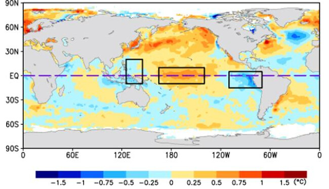
If a traditional El Niño doesn’t look as if it’s going to develop does that mean we won’t see an El Niño? No, just a different type. Modoki is the Japanese term for “similar, but different”. A Modoki El Niño is a specific sub-type of El Niño pattern that has the warmest water in the central and western Pacific Ocean. This is what a Modoki El Niño would look like in terms of sea surface temperature anomalies:

14540981498_9a331b8c09_b.jpg

Notice where the warmest water resides in the equatorial Pacific Ocean, right in the central/west central region. Comparatively cooler water is located just off the west coast of South America, where the warmest water exists as of right now. The transition that takes place in the next few months will likely allow the water off the west coast of South America to cool, while the central Pacific warms.
Make sure you check out the rest of Brian’s article, as it provdies a much more in-depth El Niño update. It provides you with a very informative, educated explanation as to what’s going on.
 

Amir Mohsen

متخصص بخش هواشناسی
امروز یک مقدار فرصت داشتم و رفتم سر وقت آرشیو عکسهای بهار سال گذشته که کلات بودم و دو تا از عکسهایی که از لحاظ نور خراب شده بود رو HDR کردم که هر دو نسخه اصلی و HDR شده این عکسها رو تقدیم دوستان خوبم میکنم:

942b15spwit2xkmlqpx.jpg


21590dzsdi77zlio2z4.jpg


7lqtnw2xbg5vkomqz6.jpg


3iimtpakui4qw1dvr34.jpg
 

سیبری

کاربر ويژه
ظاهرا سیل دیروز رابر خیلی بزرگ و بارش هم خیلی شدید و طبق گفته فرماندار 3 ساعت به طول کشیده!
 

سیبری

کاربر ويژه
رابر بهشت گمشده جنوب ایران
دیروز کوه های 4000 متر رابر در چنبره همرفتهای مانسون ایرانی!


bo6oqgj18pfnis5s1o7.jpg
 

سیبری

کاربر ويژه
سیل در «رابر» 2 هزار نفر را بی‌خانمان کرد
طغیان رودخانه‌های فصلی و وقوع سیل در رابر، 2 هزار نفر را در 9 روستا بی‌خانمان کرد.

13930429000757_PhotoA.jpg


حسین درخشان، سخنگوی سازمان امداد و نجات هلال احمر از وقوع سیل و طغیان رودخانه‌های فصلی در رابر از توابع استان کرمان خبر داد.

وی گفت: سیل 9 روستا را تحت تأثیر قرار داده و باعث شده است تا 2 هزار نفر دچار مشکل شوند.

سخنگوی سازمان امداد و نجات هلال احمر از امدادرسانی به 800 نفر از سیل زدگان خبر داد و گفت: 200 نفر از آنها به مناطق امن انتقال داده شده‌اند.

وی همچنین افزود:600 خودرو نیز از گل و لای بیرون کشیده شده است.

به گفته وی، عملیات امداد رسانی همچنان ادامه دارد و تاکنون 50 نفر نیز به صورت سرپایی درمان شده‌اند.
 

AFSORDE

کاربر ويژه
1Ardebil (Iran)8.8 °C
2Sarab (Iran)9.4 °C
3Ghuchan (Iran)11.4 °C
4Bojnourd (Iran)12.6 °C
5Orumieh (Iran)12.8 °C
6Ahar (Iran)13.4 °C
7Saghez (Iran)13.7 °C
8Zanjan (Iran)15.1 °C
9Shahre-Kord (Iran)15.6 °C
10Ghazvin (Iran)15.9 °C
11Hamedan (Iran)16.3 °C
12Torbat-Heydarieh (Iran)16.7 °C
13Mohabad (Iran)17.2 °C
14Ferdous (Iran)17.4 °C
15Makko (Iran)17.4 °C
16Mashhad (Iran)17.4 °C
17Shahrud (Iran)17.8 °C
18Sarakhs (Iran)18.4 °C
19Yasoge (Iran)18.4 °C
20Abadeh (Iran)19.0 °C
21Meyaneh (Iran)19.0 °C
22Tabriz (Iran)19.0 °C
23Arak (Iran)19.2 °C
24Pars Abad Moghan (Iran)19.4 °C
25Khoy (Iran)19.6 °C
26Maragheh (Iran)19.8 °C
27Kermanshah (Iran)19.9 °C
28Rasht (Iran)20.2 °C
29Gharakhil (Iran)20.4 °C
30Gorgan (Iran)20.4 °C
31Khorram Abad (Iran)20.6 °C
32Maraveh-Tappeh (Iran)20.6 °C
33Birjand (Iran)20.7 °C
34Kashmar (Iran)20.8 °C
35Zahedan (Iran)20.9 °C
36Ali-Goodarz (Iran)21.0 °C
37Noshahr (Iran)21.0 °C
38Esfahan (Iran)21.4 °C
39Sabzevar (Iran)21.4 °C
40Ramsar (Iran)21.8 °C
41Shiraz (Iran)21.8 °C
42Babulsar (Iran)22.0 °C
43Baft (Iran)22.0 °C
44Anzali (Iran)22.4 °C
45Ilam (Iran)22.6 °C
46Nehbandan (Iran)23.1 °C
47Kerman (Iran)23.4 °C
48Fasa (Iran)23.6 °C
49Sirjan (Iran)24.2 °C
50Sanandaj (Iran)24.6 °C
51Semnan (Iran)24.6 °C
52Kashan (Iran)24.8 °C
53Khor (Iran)24.8 °C
54Tehran-Mehrabad (Iran)25.4 °C
55Gach Saran Du Gunbadan (Iran)26.0 °C
56Yazd (Iran)26.0 °C
57Saravan (Iran)26.6 °C
58Zabol (Iran)26.6 °C
59Abadan (Iran)28.6 °C
60Bandar-E-Dayyer (Iran)28.6 °C
61Omidieh (Iran)28.6 °C
62Chahbahar (Iran)28.7 °C
63Safi-Abad Dezful (Iran)29.0 °C
64Tabas (Iran)29.1 °C
65Bushehr Civ / Afb (Iran)29.4 °C
66Abu Musa (Iran)29.6 °C
67Jask (Iran)29.6 °C
68Kharg (Iran)29.6 °C
69Kish Island (Iran)30.0 °C
70Bandarabbass (Iran)30.1 °C
71Ahwaz (Iran)30.2 °C
72Bushehr (Iran)30.2 °C
73Bandar Lengeh (Iran)30.4 °C
74Kahnuj (Iran)30.4 °C
75Bam (Iran)31.3 °C
76Masjed-Soleyman (Iran)31.7 °C
77Siri Island (Iran)31.8 °C
78Iranshahr (Iran)34.3 °C


سیبری

کاربر ويژه
دیشب واقعا شب سردی در قوچان بود وقتی میگم سرد یعنی طوریکه مسافران زیادی رو در پارکهای قوچان دیدم که پتودورخودشون پیچیده بودن وبچه هایی که کلاه وکاپشن داشتن
خوب چیزی که حس سرما رو در قوچان بیشتر میکنه وزش باد هست که ازبعد ازظهر تا نیمه شب ادامه داره
 

سیبری

کاربر ويژه
قوچان کمینه 9
بیشینه 28
امروز به دره و رودخانه اترک میرم و احتمالا سری هم به سد تبارک بزنم
 

Amir Mohsen

متخصص بخش هواشناسی
POLAR LOW - METEOROLOGICAL PHYSICAL BACKGROUND
by KNMI

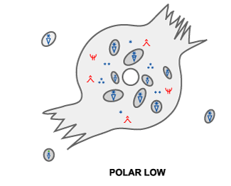
A Polar Low is a meso-scale cyclone with a warm core only existing in a cold airmass at quite a distance from the polar front. They occur in the winter period between October and May. In its mature phase the surface winds are near or above gale force. The reason why a Polar Low develops within a small baroclinic disturbance in a potentially unstable environment in northern regions can be explained with the Rossby radius of deformation: R~N[SUB]0[/SUB]H/f. In this equation, f is the coriolis parameter, N[SUB]0[/SUB] is the stability parameter, H is the scale height and R is the minimum scale of a system to be dynamically stable. The saturated-adiabatic lapse rate (small N[SUB]0[/SUB]), the northern position (large f) and very cold airmass (small H), result in an R being significantly smaller in a Polar Low environment than in an environment of an extra tropical cyclone.
In the lifecycle of a Polar Low three different phases can be distinguished: the initial or developing phase, the mature phase and the decaying phase. In the developing or initial phase baroclinicity and upper level triggering by positive vorticity advection (PVA) and potential vorticity (PV) play an important role. In the mature phase convection is often the driving force.

[h=2]Developing/initial phase
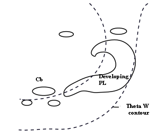
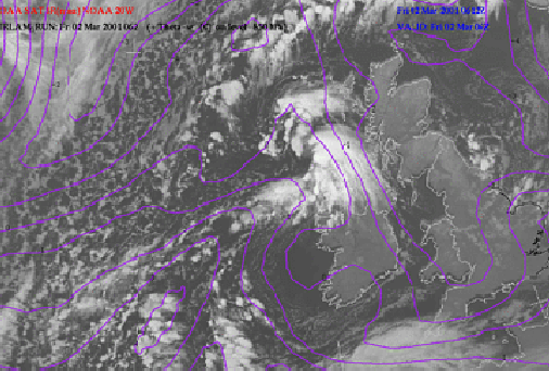
[h=3]Baroclinicity In most cases a Polar Low develops on a secondary shallow baroclinic zone in a polar or arctic airmass far away from the polar front. This baroclinic zone can have different origins. The zone could be a border between air from ice fields and maritime polar air (Arctic Front), or the remnants of an Occlusion. The enhanced cloudband, indicating the baroclinic zone, is a result of both positive vorticity advection and advection of warm air. Normally this zone can be visualised in the potential equivalent temperature (ThetaE) contours at 850 hPa. The potential wet bulb temperature (ThetaW) shows a similar pattern.
Very cold air overlays the baroclinic zone, resulting in a (potential) unstable atmosphere.

02 March 2001/06.00 UTC - NOAA Ch4 image; magenta: ThetaW 850 hPa
plcosk1k.gif

plco01k.gif


In the example above a polar low is developing west of Scotland in a gradient zone of Theta[SUB]W[/SUB].
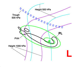
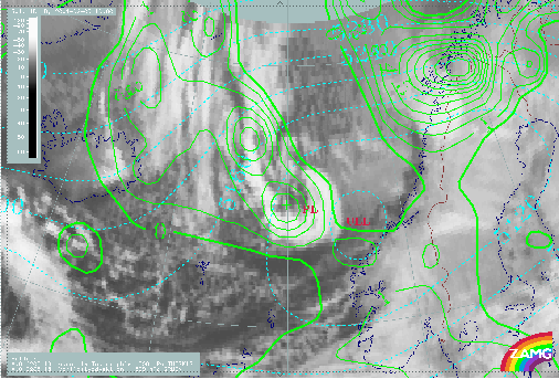
[h=3]Curvature Vorticity Advection A Polar Low normally develops within a surface trough and in front of an upper trough within the cold air mass behind a major depression or Cold Front. Positive vorticity advection (PVA) plays an important role in the spin up of the low. The upper level trough overruns the band of enhanced cloudiness and causes this PVA. In many cases this process happens at a trough of a large scale decaying Upper Level Low (ULL) which is often already accompanied by a low at the surface. Therefore curvature vorticity advection also plays a dominant role.

05 February 2001/18.00 UTC - Meteosat IR image; green: positive vorticity advection (PVA), cyan: height contours 500 hPa
plcosk2k.gif

plco02k.gif


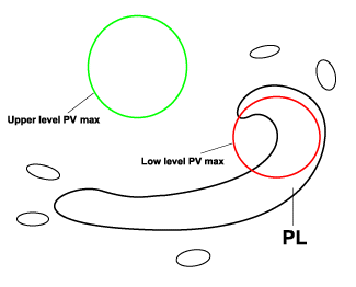
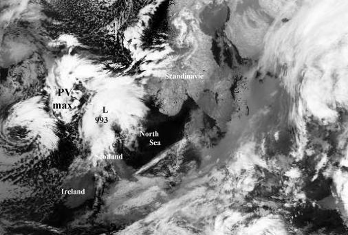
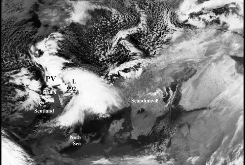
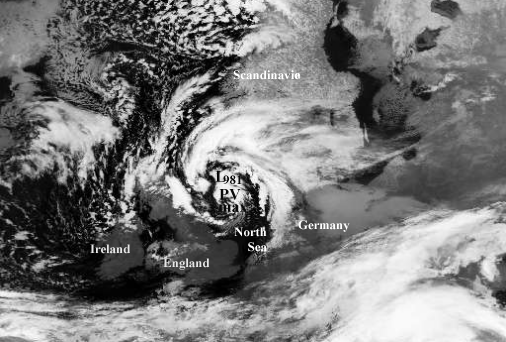
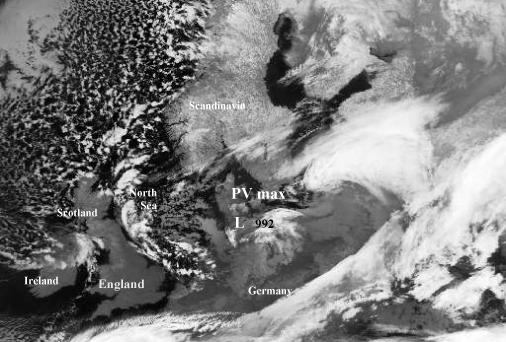
[h=3]Potential Vorticity Another triggering mechanism, although closely related to vorticity advection, is the advection of potential vorticity (PV). The baroclinic band can be regarded as a low level PV anomaly. If an upper level anomaly of high potential vorticity values overruns the baroclinic band or low level PV anomaly, both upper and lower level PV maximum will reinforce each other and start a spin-up process. This spin-up process, however, will only be possible if the cyclonic flow induced by the upper level PV anomaly can penetrate sufficiently deep down into the troposphere (see Introduction chapter - Additional parameters and helpful tools for the diagnosis of cloudiness: Potential vorticity ). Potential vorticity triggering a Polar Low
plcosk3k.gif


24 December 1995/02.17 NOAA CH4 image
24 December 1995/12.12 NOAA CH4 image
plco03k.gif

plco04k.gif

plco05k.gif

plco06k.gif

25 December 1995/07.32 NOAA CH4 image
26 December 1995/01.55 NOAA CH4 image

An example of a Polar Low induced by high PV values occurred during Christmas 1995. On 24 December 06.00 UTC a baroclinic band (not shown in the sequence of the above images) was positioned between Scotland and Norway with cold arctic air to the north and polar air in the south. Before the development started, a weak cyclone with a low level PV maximum was already present just north of Scotland. During the development period an upper level maximum of PV high in the troposphere shifted southward causing positive PV advection above the weak cyclone. Interaction between the two maxima took place triggering the formation of a Polar Low. On 25 December 06.00 UTC the Polar Low reached its mature state. At this moment the upper level PV maximum passed the centre of the polar low moving to the south. Eighteen hours later the polar low passed the coastline of Germany and started to decay.
[h=2]Mature phase
[h=3]Conditional Instability of the Second Kind (CISK) As a result of an unstable or potentially unstable atmosphere, deep convection starts in the developing phase of a Polar Low. This convection is fed by strong latent and sensible heat fluxes resulting from a large difference between air and sea surface temperature and due to high wind speed.
The latent heat release from convection and the Ekman pumping due to a low level cyclonic circulation result, according to the CISK-theory (see Comma ), in a positive feedback mechanism resulting in a deepening of the Polar Low.
[h=3]Warm core/eye formation A striking feature in the mature stage of a Polar Low is the formation of a warm core. In some cases (see Cloud structure in satellite images) the inner part of the warm core is cloudless resembling a hurricane eye.
There are two main mechanisms responsible for the formation of a warm core.
  1. Relatively warm air is transported to the centre of the Polar Low and finally cut off from the main flow.
  2. A warm core can be formed by convection. Enhanced surface winds cause enhanced latent and sensible heat fluxes. This heat will be transported aloft by convection. As already shown, the redistribution of heat by convection is important in the intensification of a Polar Low.

Very low surface pressures at the centre, sinking air and high windspeed in the surrounding wall of cloud all chracterize the eye of a tropical hurricane. Although satellite images sometimes show eyes or eye-like features in Polar Low formations, so far there is no evidence of exceptionally low surface pressure values or extremely high windspeed around the central region.
To evaluate the potential for eye formation in a Polar Low, it is necessary to consider the radiosonde ascent. If for example an individual updraft is followed by descending upper level air in the potential eye region, an eye will only form if the potential wet bulb temperature (ThetaW) of the descending air is considerably higher than the ThetaE of the air involved in the updraft.
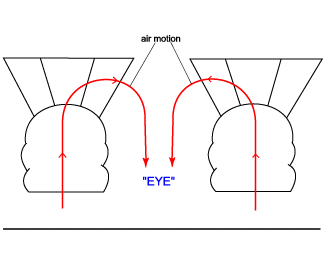
A warm eye would form if high ThetaW surface air, after ascending in the eye wall, would start to subside in the (interior) eye region (figure below). Even in this case, however, only a relatively small increase in the mean temperature of the column could be expected in the eye of a Polar Low. This is because of the low moisture content of the cold air resulting in relatively small temperature changes as result of the release of latent heat. Therefore Polar Lows only form eyes under special conditions.
plcosk4k.gif


[h=2]Decaying phase Polar Lows usually start to decay after landfall or "icefall". Their central surface pressure starts to increase and their strong wind fields disappear. Three effects are mainly responsible for this decay:

  • Reduction in evaporation
    An important source of energy is the evaporation of seawater. After landfall this source disappears resulting in a decay of the Polar Low.
  • Reduction in sensible heat flux
    During wintertime the land surface normally is colder than the sea surface. Therefore the sensible heat flux will be reduced after landfall of a Polar Low.
  • Increase in surface roughness
    The roughness of the land surface is greater than the roughness of the sea surface. Therefore, when a Polar Low reaches land, this increase in roughness results in enhanced surface convergence. The net inflow results in increased surface pressure, assuming a weaker adjustment of upper level divergence.
Polar Lows associated with strong baroclinicity are not necessarily dependent on energy sources such as sensible and latent heat fluxes. Therefore, these Polar Lows may not necessarily decay after landfall. Baroclinic Polar Lows normally start to decay when negative dynamic forcing mechanisms like cold air advection or negative vorticity advection start to play a dominant role.

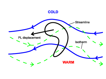
[h=2]Special phenomenon: Reverse-shear Polar Lows Some Polar Lows are called reverse-shear Polar Lows. The wind at the steering level is light and generally opposite to the thermal wind. The Polar Low is located where the thermal wind advects positive vorticity.
plcosk5k.gif


Amir Mohsen

متخصص بخش هواشناسی
POLAR LOW - WEATHER EVENTS
by KNMI

Polar Lows are mesoscale weather systems. During their life cycle they produce severe weather with strong surface winds and locally heavy precipitation. Due to the very cold environment of a Polar Low most of the precipitation is falling as snow. During landfall convective Polar Lows only produce significant precipitation in the coastal area. Some Polar Lows show a small-scale baroclinic zone resulting in a more frontal type of precipitation. These Polar Lows will shift farther inland producing hazardous weather conditions with heavy snowfall and strong wind gusts.

Parameter Description
Precipitation In developing phase: widespread light to moderated showers
In mature phase: heavy (snow) showers in most cases
Temperature Around freezing point but in centre slightly warmer. Strong decrease in temperature directly after passage of the centre.
Wind Mean wind > 27 kts/14 m/s or >=7 bft. Strong windgusts. Max wind occurs where relative motion of the Polar Low is in same direction as the wind direction.
Other relevant information Thunderstoms or even small tornadoes are possible.
The heaviest showers are located close to the centre. Occasionally these showers are thunderstorms with strong wind gusts. Even some small tornadoes are observed.
High risk of icing over sea. Blizzard conditions over land.

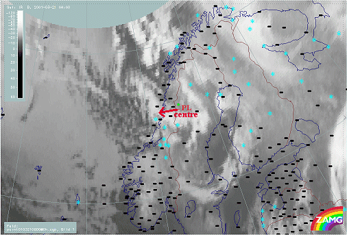
21 March 2001/06.00 UTC - Meteosat IR image; Weather events in a Polar Low near the west coast of Norway
plwesk1k.gif

plwe01k.gif


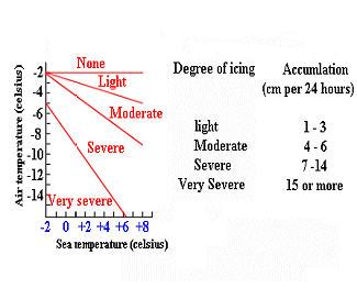
[h=2]Icing on ships Normally Polar Lows reach their mature stage over sea. Therefore ships have to be aware of the hazardous weather conditions. One of the risks small boats have to be aware of is icing. Because of the strong winds and the low air temperature, spray may freeze on the superstructure of a boat. The weight of accumulated ice may eventually become a considerable hazard.
The degree of icing depends both on temperature and wind speed, as shown in the figure below. Degree of icing with a wind of 8-9 bft. (> 41 kt./21 m/s)
plwesk2k.gif


Amir Mohsen

متخصص بخش هواشناسی
سلام


زمستون سال گذشته تا دلتون بخواد از این کم فشار های قطبی از مسیر اصلی خودش بخاطر وقوع شکست در امواج راسبی به عرضهای پایین تر خصوصا کشور ما کشیده شدند و طوفان برف در غرب خاورمیانه و همچنین شمال غرب ایران و استان فارس و حتی برفهایی که در مناطق کویری ایران بارید ناشی از همین کم فشار ها بود.
 
آخرین ویرایش:
وضعیت
موضوع بسته شده است.
بالا