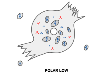
POLAR LOW - METEOROLOGICAL PHYSICAL BACKGROUND
by KNMI
A Polar Low is a meso-scale cyclone with a warm core only existing in a cold airmass at quite a distance from the polar front. They occur in the winter period between October and May. In its mature phase the surface winds are near or above gale force. The reason why a Polar Low develops within a small baroclinic disturbance in a potentially unstable environment in northern regions can be explained with the Rossby radius of deformation: R~N[SUB]0[/SUB]H/f. In this equation, f is the coriolis parameter, N[SUB]0[/SUB] is the stability parameter, H is the scale height and R is the minimum scale of a system to be dynamically stable. The saturated-adiabatic lapse rate (small N[SUB]0[/SUB]), the northern position (large f) and very cold airmass (small H), result in an R being significantly smaller in a Polar Low environment than in an environment of an extra tropical cyclone.
In the lifecycle of a Polar Low three different phases can be distinguished: the initial or developing phase, the mature phase and the decaying phase. In the developing or initial phase baroclinicity and upper level triggering by positive vorticity advection (PVA) and potential vorticity (PV) play an important role. In the mature phase convection is often the driving force.
[h=2]Developing/initial phase
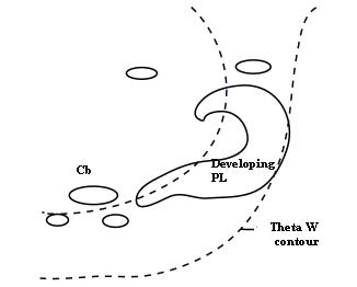
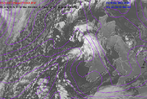
[h=3]Baroclinicity In most cases a Polar Low develops on a secondary shallow baroclinic zone in a polar or arctic airmass far away from the polar front. This baroclinic zone can have different origins. The zone could be a border between air from ice fields and maritime polar air (Arctic Front), or the remnants of an Occlusion. The enhanced cloudband, indicating the baroclinic zone, is a result of both positive vorticity advection and advection of warm air. Normally this zone can be visualised in the potential equivalent temperature (ThetaE) contours at 850 hPa. The potential wet bulb temperature (ThetaW) shows a similar pattern.
Very cold air overlays the baroclinic zone, resulting in a (potential) unstable atmosphere.
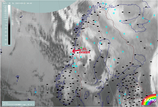
| 02 March 2001/06.00 UTC - NOAA Ch4 image; magenta: ThetaW 850 hPa
|
|
|
In the example above a polar low is developing west of Scotland in a gradient zone of Theta[SUB]W[/SUB].
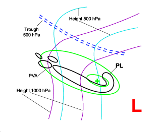
[h=3]Curvature Vorticity Advection A Polar Low normally develops within a surface trough and in front of an upper trough within the cold air mass behind a major depression or Cold Front. Positive vorticity advection (PVA) plays an important role in the spin up of the low. The upper level trough overruns the band of enhanced cloudiness and causes this PVA. In many cases this process happens at a trough of a large scale decaying Upper Level Low (ULL) which is often already accompanied by a low at the surface. Therefore curvature vorticity advection also plays a dominant role.
| 05 February 2001/18.00 UTC - Meteosat IR image; green: positive vorticity advection (PVA), cyan: height contours 500 hPa
|
|
|
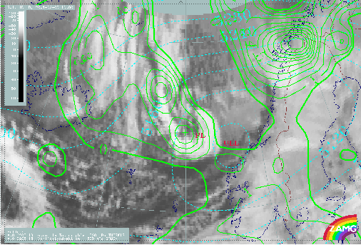
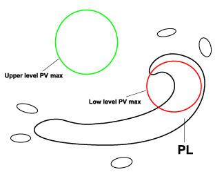
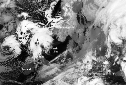
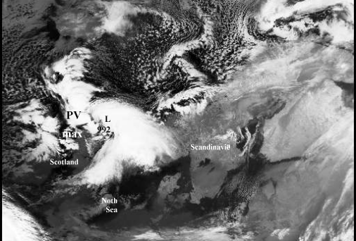
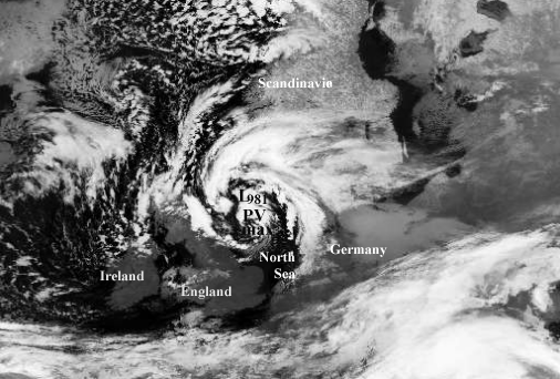
[h=3]Potential Vorticity Another triggering mechanism, although closely related to vorticity advection, is the advection of potential vorticity (PV). The baroclinic band can be regarded as a low level PV anomaly. If an upper level anomaly of high potential vorticity values overruns the baroclinic band or low level PV anomaly, both upper and lower level PV maximum will reinforce each other and start a spin-up process. This spin-up process, however, will only be possible if the cyclonic flow induced by the upper level PV anomaly can penetrate sufficiently deep down into the troposphere (see
Introduction chapter - Additional parameters and helpful tools for the diagnosis of cloudiness: Potential vorticity ). Potential vorticity triggering a Polar Low
24 December 1995/02.17 NOAA CH4 image
| 24 December 1995/12.12 NOAA CH4 image
|
|
|
|
|
25 December 1995/07.32 NOAA CH4 image
| 26 December 1995/01.55 NOAA CH4 image
|
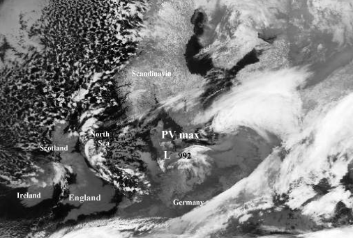
An example of a Polar Low induced by high PV values occurred during Christmas 1995. On 24 December 06.00 UTC a baroclinic band (not shown in the sequence of the above images) was positioned between Scotland and Norway with cold arctic air to the north and polar air in the south. Before the development started, a weak cyclone with a low level PV maximum was already present just north of Scotland. During the development period an upper level maximum of PV high in the troposphere shifted southward causing positive PV advection above the weak cyclone. Interaction between the two maxima took place triggering the formation of a Polar Low. On 25 December 06.00 UTC the Polar Low reached its mature state. At this moment the upper level PV maximum passed the centre of the polar low moving to the south. Eighteen hours later the polar low passed the coastline of Germany and started to decay.
[h=2]Mature phase
[h=3]Conditional Instability of the Second Kind (CISK) As a result of an unstable or potentially unstable atmosphere, deep convection starts in the developing phase of a Polar Low. This convection is fed by strong latent and sensible heat fluxes resulting from a large difference between air and sea surface temperature and due to high wind speed.
The latent heat release from convection and the Ekman pumping due to a low level cyclonic circulation result, according to the CISK-theory (see
Comma ), in a positive feedback mechanism resulting in a deepening of the Polar Low.
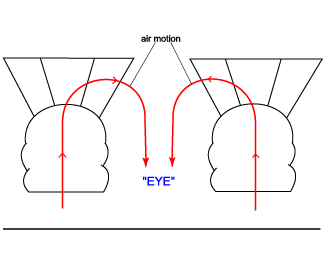
[h=3]Warm core/eye formation A striking feature in the mature stage of a Polar Low is the formation of a warm core. In some cases (see Cloud structure in satellite images) the inner part of the warm core is cloudless resembling a hurricane eye.
There are two main mechanisms responsible for the formation of a warm core.
- Relatively warm air is transported to the centre of the Polar Low and finally cut off from the main flow.
- A warm core can be formed by convection. Enhanced surface winds cause enhanced latent and sensible heat fluxes. This heat will be transported aloft by convection. As already shown, the redistribution of heat by convection is important in the intensification of a Polar Low.
Very low surface pressures at the centre, sinking air and high windspeed in the surrounding wall of cloud all chracterize the eye of a tropical hurricane. Although satellite images sometimes show eyes or eye-like features in Polar Low formations, so far there is no evidence of exceptionally low surface pressure values or extremely high windspeed around the central region.
To evaluate the potential for eye formation in a Polar Low, it is necessary to consider the radiosonde ascent. If for example an individual updraft is followed by descending upper level air in the potential eye region, an eye will only form if the potential wet bulb temperature (ThetaW) of the descending air is considerably higher than the ThetaE of the air involved in the updraft.
A warm eye would form if high ThetaW surface air, after ascending in the eye wall, would start to subside in the (interior) eye region (figure below). Even in this case, however, only a relatively small increase in the mean temperature of the column could be expected in the eye of a Polar Low. This is because of the low moisture content of the cold air resulting in relatively small temperature changes as result of the release of latent heat. Therefore Polar Lows only form eyes under special conditions.
[h=2]Decaying phase Polar Lows usually start to decay after landfall or "icefall". Their central surface pressure starts to increase and their strong wind fields disappear. Three effects are mainly responsible for this decay:
- Reduction in evaporation
An important source of energy is the evaporation of seawater. After landfall this source disappears resulting in a decay of the Polar Low.
- Reduction in sensible heat flux
During wintertime the land surface normally is colder than the sea surface. Therefore the sensible heat flux will be reduced after landfall of a Polar Low.
- Increase in surface roughness
The roughness of the land surface is greater than the roughness of the sea surface. Therefore, when a Polar Low reaches land, this increase in roughness results in enhanced surface convergence. The net inflow results in increased surface pressure, assuming a weaker adjustment of upper level divergence.
Polar Lows associated with strong baroclinicity are not necessarily dependent on energy sources such as sensible and latent heat fluxes. Therefore, these Polar Lows may not necessarily decay after landfall. Baroclinic Polar Lows normally start to decay when negative dynamic forcing mechanisms like cold air advection or negative vorticity advection start to play a dominant role.
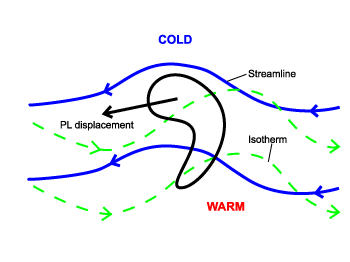
[h=2]Special phenomenon: Reverse-shear Polar Lows Some Polar Lows are called reverse-shear Polar Lows. The wind at the steering level is light and generally opposite to the thermal wind. The Polar Low is located where the thermal wind advects positive vorticity.