• توجه: در صورتی که از کاربران قدیمی ایران انجمن هستید و امکان ورود به سایت را ندارید، میتوانید با آیدی altin_admin@ در تلگرام تماس حاصل نمایید.

مباحث عمومی هواشناسی

وضعیت
موضوع بسته شده است.

Amir Mohsen

متخصص بخش هواشناسی
[h=2]Dazzling Northern Lights Anticipated Saturday Night
suehr.png
[h=6]By Samantha-Rae Tuthill, AccuWeather.com Staff Writer [h=5]April 12, 2013; 8:51 AM
Share |​

300x140_04121203_6278797068_f3d68d8c64.jpg
A solar flare that occurred around 2 a.m. Thursday morning may create a spectacular display of northern lights Saturday evening. The midlevel flare had a long duration and was directed at Earth. According to AccuWeather.com Astronomer Hunter Outten, who stated that this flare was "impressive", these are the best conditions for seeing a direct effect on our planet. On the Kp index, the flare has been categorized at 6 to 8. This is a scale for measuring the intensity of a a geomagnetic storm. The 6 to 8 rating means that the effects of the radiation will have a greater reach.​
640x320_04121425_16203_561819853857879_1815767595_n.jpg
The radiation from such a flare may cause radio wave disturbances to electronics such as cell phones, GPS and radios, causing services to occasionally cut in and out. While traveling slower than was originally anticipated, the flare effects are moving towards Earth at 1000 km per second.​
640x426_04121419_page.jpg
The more directly a flare faces Earth, the higher the effect will be​
The flare is also expected to cause vibrant northern lights from the Arctic as far south as New York, the Dakotas, Washington and Michigan, with a smaller possibility of it going into Pennsylvania and Iowa, even Kansas. The lights are currently estimated for 8 p.m. EDT Saturday arrival, with a possible deviation of up to seven hours. If the radiation hits much after dark settles on the East Coast the lights may be missed and will instead only be visible for the West.​
501x333_04121246_6278797068_f3d68d8c64.jpg
A view of the northern lights in Elmira, N.Y., from 2011. Photo by David St. Louis
Solar flares create auroras when radiation from the sun reaches Earth and interacts with charged protons in our atmosphere. The effects are greater at the magnetic poles and weaken as they move south from the Arctic or north of the Antarctic. In the northern hemisphere the results are called the aurora borealis, with the aurora australis being its southern counterpart. The result is a spectacular display of light and color for areas with clear enough views.​
640x426_04121426_page.jpg
Viewing conditions will be best in the mid-Atlantic, specifically for parts of Pennsylvania and the Delmarva. Most of the country will have poor to fair views as a result of cloud cover, with areas further south not experiencing the aurora at all. A pocket of fair conditions sits over southeastern Oregon and the southwest corner of Idaho. A swath of partly cloudy conditions will also spread over a section of the Ohio Valley for parts of Michigan, Indiana and Illinois. Ohio will experience fair to good viewing conditions. For the rest of the country conditions will be poor.​
View more on information on AccuWeather.com's Astronomy ******** Page.
 

nojeana

کاربر ويژه
Study: Arctic Summers Warmest in 600 Years


  • Published: April 12th, 2013 , Last Updated: April 12th, 2013


By Michael D. Lemonick
Follow @MLemonick
The Arctic has seen warmer summers over the past two decades than at any time in the past 600 years, according to a study published this week in the journal Nature. The study uses a sophisticated statistical approach, known as Bayesian modeling, to show that the extremely warm summers in high northern latitudes are evidence of an overall warming trend, rather than just a temporary fluctuation in an otherwise unchanging climate.
Surface temperatures in the Arctic were much warmer than average for the first decade of the 21st century, as shown in this image.
Click on the image to enlarge. Credit: NOAA.
That’s a crucial distinction: a natural fluctuation might reverse before the full effects of warm temperatures could set in, including the melting of Greenland’s ice cap, which could lead to a significant rise in sea level, and ice-free summers in the Arctic Ocean, which could trigger problematic weather anomalies in other parts of the globe.
Scientists have already shown that a warming climate will automatically generate more high-temperature records than a stable one. That’s because individual temperature measurements in a given location form a bell curve, with the greatest number of readings falling into the “normal” range for that location. A small number of readings will fall well above normal, however, and an equally small number will fall below.
If the normal range shifts, however, because the climate is warming overall, high temperatures that once came along very rarely will happen more often, while extreme cold temperatures will become even rarer. A 2012 paper by James Hansen, who recently retired from his post at NASA’s Goddard Institute for Space Studies, showed how this must be true for daily temperatures, but the same principle applies to seasonal averages.
The problem here is that people haven’t been taking comprehensive readings of temperatures in the high Arctic for very long, so they rely on proxies such as tree-ring thickness to stand in for temperature. And those proxies, said lead author Martin Tingley, an expert in climate statistics at Harvard, “carry significant uncertainties.”
Tingley likes to use an analogy: “I’m six-feet-four, which is significantly above average. So even if I’ve never met you, I can confidently guess that I’m probably taller than you are.” But if Tingley were about to enter a room with a thousand men already inside, he couldn’t be equally confident that he’d be the tallest.
It’s the same with summer average temperatures in the Arctic. “From a statistics perspective,” he said, “it’s very different to ask ‘is this summer warmer than the summer of 1473’ and ‘is this summer warmer than all summers in the past 600 years?’”
With precise records, you could just look it up, but the uncertainties in climate proxies make it much more difficult — and without going into the virtues and technical details of different statistical techniques, it turns out that Bayesian analysis is ideally suited to answer that broader question.
The answer, write Tingley and his co-author Peter Huybers, also of Harvard: “…we show that the magnitude and frequency of recent warm temperature extremes at high northern latitudes are unprecedented in the past 600 years.”
Tingley and Huybers’ analysis shows, moreover, that these recent extremes are best explained by an overall rise in average temperatures. That is right in line with an overwhelming body of evidence showing that man-made greenhouse gas emissions have already driven global temperatures higher, and will continue to do so as the century progresses.
Rapid Arctic climate change has resulted in a stunning decline in Arctic sea ice cover, with 2012 setting the record for the lowest ice extent since satellite observations began in 1979. The plunge in sea ice is helping to boost temperatures by exposing greater areas of dark, open ocean, which absorbs more incoming solar radiation that the brightly colored ice does.
Related Content:
پس امسال یخهای قطبی وضعیت وحشتناکی خواهند داشت؟
حالا پیامدش برای ایران چی می شه؟
 

nojeana

کاربر ويژه

Heavy Wind and Strong Winds for Ireland


By Mark Paquette

April 12, 2013; 9:11 AM


Share |

300x140_04121131_europe.jpg

While an area of area high pressure is over central Europe and brings a warming trend to western Europe this weekend, a strong low pressure system over the Atlantic will cause a cold front to impact Ireland on Saturday and parts of the United Kingdom Sunday.
This feature will spread heavy rain across Ireland. Rainfall amounts are expected to average 1.00-1.50 inches (25-38 mm) across Dublin with localized as high as 2.00 inches (51 mm) which will lead to areas of flooding.
Accompanying the heavy rain, south to southwesterly winds ahead of the cold front will average 30-40 mph (50-65 km/h) with gusts as high as 50 mph (80 km/h). As a result, power outages will occur across parts of Ireland on Saturday due to downed trees and power lines.
اروپای پر بارش همیشه برای ایران کابوس بوده مخصوصا اروپای غربی پر بارش خدا رحم کنه خدا نکنه ایران دوباره وارد یه دوره جدید خشک بشیم
 

Fooladi

کاربر ويژه
دو هفته است اینترنتم افتضاحه و دیگه نمی تونم دنبال کنم اینجا رو :ناراحت: شب به خیر
 

Fooladi

کاربر ويژه
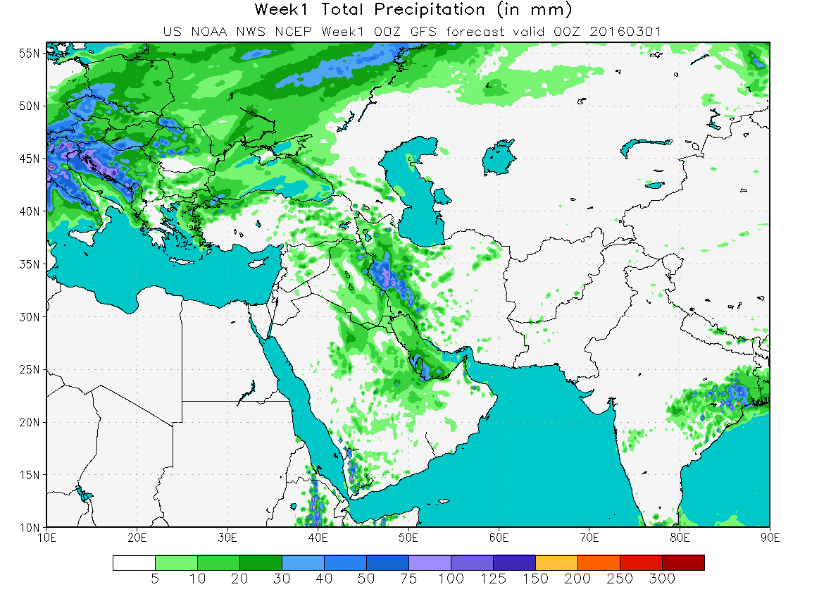
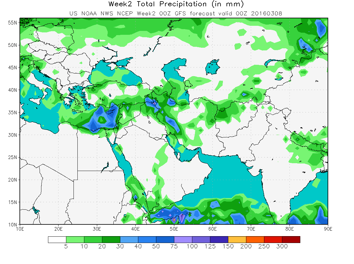
مرز استانها معلومه ولی دقت GFS برا استان شما برا این موقع از سال رو خودتون نتیجه گیری کنید.
week1_totp_b.png

week2_totp_b.png
 
آخرین ویرایش:

ali.doosti

کاربر ويژه
کلا امسال ساله ما نبودش نه پاییز نه زمستون نه بهارش!! این بارشایی که تو این بهار اتفاق افتاده واسه تهران بارش نیستش که!!! باید رعدوبرق بکوبه وسط اسفالت خیابون دل ملت از ترس بترکه بدش تگرگ و بارونی بیادش که حداقل اب از جوبا بزنه بیرون. این نوع بارش واسه من معنی بارش بهاری رو میده!!
سعید امسال ششمین سال خشگ پیاپی ماست...
زیادسخت نگیر!
 

سامیار هواشناس

کاربر ويژه
بارش برف ارتفاعات توچال را شبه سفید کرد
بارش برف امروز با وجود جزیی بودم مقدار بارش و به دلیل برودت مناسب هوا از ارتفاع 3000 متری به بالا توچال را تماما سفید پوش کرد
 

Amir Mohsen

متخصص بخش هواشناسی
سلام دوستان و صبح همگی بخیر

من رسیدم کلات و باید بگم که اون ابر تندری که دیشب از حاشیه غربی مشهد به سمت شمال و هزارمسجد منحرف شد منجر به بارش شدید تگرگ در کلات نادر شده که زمین رو هم سپید پوش کرده بود.
 

amir tehranpars

کاربر ويژه
از کجا با اطمینان میگی ؟ به نظر من در تهران هم منفیش هم مثبتش موجب بارش های خوب شده .

بله ، دقیقا !
ما شرایطی داشتیم که مثبت شدن و یا منفی شدن در تهران موجب بارش های خوبی شده ولی اگر مثلا یک دوره 10 ساله رو درنظر بگیریم ومیزان منفی شدن این شاخص رو با بارش در یک نمودار همدیدی درنظر بگیریم ، میبینی که حدود 70 درصد بارشها با منفی شدن این شاخص همخونی داشته !
 

amir tehranpars

کاربر ويژه
هرچند که بهار گرمی رو داریم میگذرونیم ولی بازم خوبه دماها این ده روز 2-3 درجه ای پایینتر از نرمال پیشبینی شده !
 

پسرخاله

کاربر ويژه
هرچند که بهار گرمی رو داریم میگذرونیم ولی بازم خوبه دماها این ده روز 2-3 درجه ای پایینتر از نرمال پیشبینی شده !
آره خدارو شکر از فردا تا شنبه هفته بعد هوای معتدل در روز و خنک در شب رو داریم. نقشه های بارندگی به شدت متغیر هستند حتی مدل نیروی دریایی!
 
وضعیت
موضوع بسته شده است.
بالا