• توجه: در صورتی که از کاربران قدیمی ایران انجمن هستید و امکان ورود به سایت را ندارید، میتوانید با آیدی altin_admin@ در تلگرام تماس حاصل نمایید.

مباحث عمومی هواشناسی

وضعیت
موضوع بسته شده است.

Amir Mohsen

متخصص بخش هواشناسی


Next Winter will be the starting point for the next Little Ice Age! The Ice Man is coming to the United States and to most of Planet Earth!
زمستان آینده (بعدی) نقطه عطفی بر آغاز عصر یخبندان جدید خواهد بود. مرد یخی از ایالات متحده ظهور خواهد کرد و غالب نقاط کره خاکی را در آغوش خواهد کشید!

We expect a powerful pattern change in the weather that will change the Polar Jet Stream in a way that extreme cold will be pulled down from the North Pole and pushed way south into the U.S. and as we get deep into this pattern, we expect temps. will run 20 to 30 degrees below normal for most of entire Winter months.


انتظار ما بر این است که تغییرات عمده ای در الگوهای آب و هوایی نمود پیدا کند، رفتار جت استریمی قطبی آنچنان دچارتغییر شود که سرمای شدید قطب شمال به عرضهای جنوبی تر ایالات متحده کشیده شود ،وقتی دقیق تر این الگوی آب و هوایی را بررسی میکنیم ، وقوع دماهایی در حدود 20 تا 30 درجه سردتر از نرمال در کل ماههای زمستان ، انتظار بی جایی نخواهد بود.

As this occurs Winter after Winter the next Little Ice Age will be upon us.

عصر یخبندان کوچک در انتظار ما خواهد بود چون این الگو در زمستانهای متوالی تکرار خواهد شد

Once we are locked into the Little Ice Age, we expect it to last 40 to 50 years or even much longer.

به محض اینکه ما وارد عصر یخبندان کوچک شویم ، این دوره یخبندان در حدود 40 الی 50 سال و یا حتی فراتر ادامه خواهد یافت.


The U.S. nor the world as a whole is ready for such an event.

نه تنها مردم ایالات متحده بلکه مردم کل دنیا باید آمادگی مواجه شدن با این پدیده را داشته باشند.


Millions of deaths will happen and the cost will run well into the billions.

میلیون ها نفر در سر تا سر دنیا جان خود را از دست خواهند داد و خسارات اقتصادی بسیار سنگین و جبران ناپذیر خواهد بود.


You can put this Global Warming stuff in the history books. It’s over and the new era is upon us. It is called, THE LITTLE ICE AGE!


شما این چرندیات در مورد گرمایش جهانی را به بایگانی کرده و به کتاب تاریخ خواهید سپرد. همه چیز در این خصوص تمام میشود و عصر جدیدی در پیش روی ما خواهد بود که به آن عصر یخبندان کوچک خواهیم گفت.


The U.S. Winters in the 60′s and 70′s were much colder than the Winters of the 80′, 90′s and 2000′s
.

زمستان های آمریکا در دهه های 1960 و 1970 میلادی خیلی سردتر از زمستان های دهه های 1980، 1990 و 2000 میلادی بود


That is about to change real fast. The sunspot activity will drop off to nothing and will stay that way for decades to come. We expect earthquake activity to rise in a very big way.


حقیقت این است که تغییرات به سرعت رخ خواهند داد. فعالیتهای خورشیدی( لکه های خورشید) متوقف خواهند شد و این روند تا دهه های آینده امتداد خواهد یافت.


We may also see a lot of volcano activity around the world over the next 10 years and beyond. If you go back in time this is nothing new. We have always had Climate Change that run in cycles.

این احتمال وجود دارد که ما ظرف 10 سال آینده شاهد وقوع فعالیتهای آتشفشانی گسترده در سر تا سر دنیا باشیم.
اگر به گذشته نگاه کنید این حرف تازه ای نیست. ما همیشه در چرخه های آب و هوایی شاهد تغییرات بوده ایم.


However, the news media has talked about Global Warming so much that the American people are not ready for what is coming their way at a very fast pace! We could very well see 40 or 50 years of extreme cold and snow during our winter months.


مردم امریکایی برای بروز چنین شرایطی تحت هیچ عنوان آمادگی نخواهند داشت چون که رسانه های خبری فقط در مورد گرمایش جهانی صحبت میکنند. ما در 40 تا 50 سال آینده شاهد زمستانهای پر برف و بسیار سرد و خشن خواهیم بود.

And each Winter will start in October and last until April. I know all this sounds bad but we really think it is coming and maybe sooner than we had bargained for. I am not going to get into all the Meteorology behind this forecast. We will save that for a later date. Thanks For Letting Me Share! Len R. Holliday


زمستان ها از اکتبر آغاز خواهند شد و تا فروردین امتداد خواهند یافت.
میدانم که صحبت در این خصوص با حس خوشایندی همراه نیست ولی ما باید فکر کنیم این حوادث زودتر از آنچیزی که بر روی کاغذ متصور هستیم رخ خواهد داد. من وارد تمام جزئیات هواشناسی در خصوص این پیش بینی نمیشم و صحبت در مورد جزئبات بیشتر این پیش بینی را به روزهای آینده موکول خواهیم کرد.

سپاس از اینکه به من اجازه اشتراک گذاری این مطلب را دادید.

لن- آر - هالیدی

 
آخرین ویرایش:

Amir Mohsen

متخصص بخش هواشناسی
در آخرین تصویر ماهواره ای هجوم و شدت وقوع رعد و برق در استانهای گلستان و خراسان شمالی به چشم میخوره:

mesatir00.gif
 

mahmood600

کاربر ويژه
UK, Ireland Face Damaging Wind Threat

The strongest storm to blast the United Kingdom and Ireland since the spring threatens to whip up damaging winds Sunday through Monday.Bouts of rain and nothing worse than breezy conditions through Saturday will precede the impending potent storm and its damaging winds.If the storm develops to its full potential, it would be capable of unleashing wind gusts of 80 to 110 kph (50 to 70 mph) from northwestern Ireland to Scotland Sunday through Monday.Northern and western coastal locations will be most susceptible to winds on the higher end of that range.
Such winds could lead to widespread tree damage and power outages, as well as minor structural damage. Additional damage will result if the trees
land on structures and cars.

More sporadic tree damage and power outages could unfold in Dublin, London and across the rest of Ireland, England and Wales where
gusts between 60 and 80 kph (35 and 50 mph) are possible.

650x366_09111212_ukwind.jpg
 

mahmood600

کاربر ويژه
[h=2]Gabrielle Takes Aim at Canada
While Tropical Storm Gabrielle will affect the island nation of Bermuda through Wednesday, it will pose a threat to Atlantic Canada before the week comes to a close.Gabrielle is expected to track northward over the next several days, maintaining its status as a tropical storm through Friday.Meanwhile, a cold front swinging through southern Quebec and the northeastern United States will move off the coast around the same time that Gabrielle is nearing Nova Scotia.

650x366_09110724_page.jpg
 

mahmood600

کاربر ويژه
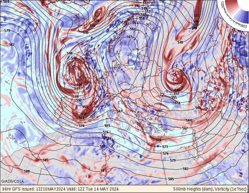
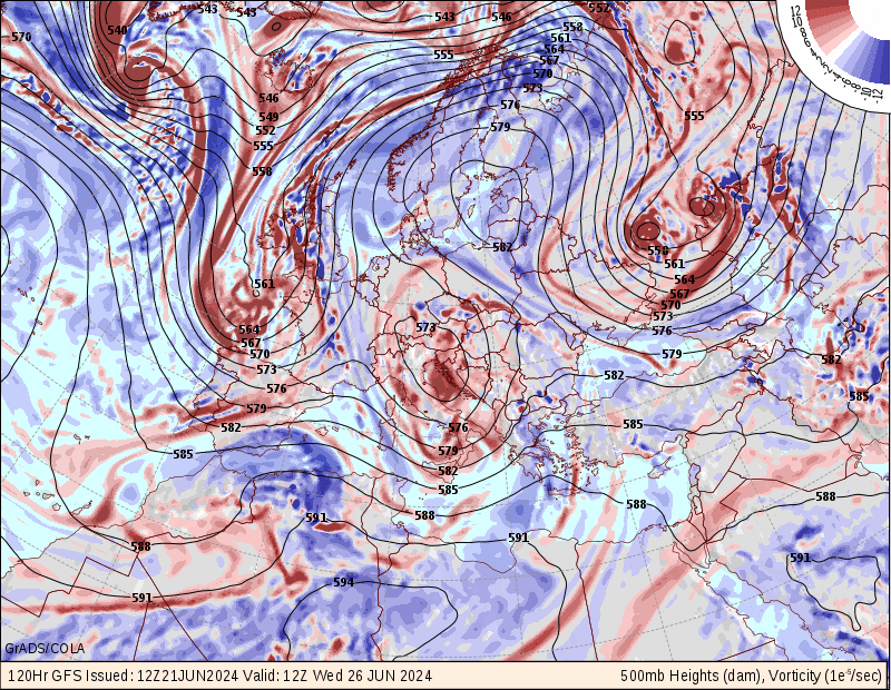
یکشنبه و دوشنبه 15 و 16 سپتامبر عجب ناوه قدرتمندی منطقه ایرلندو بریتانیای کبیر رو در بر خواهد گرفت

euro1.96hr.png

euro1.120hr.png
 

Amir Mohsen

متخصص بخش هواشناسی
Today in Weather History
for September 11

September 11, 1949
An early snowstorm brought 7.5 inches to Helena MT. In Maine, a storm drenched New Brunswick with 8.05 inches of rain in 24 hours, a state record. (The Weather Channel)​


September 11, 1961
Very large and slow moving Hurricane Carla made landfall near Port Lavaca TX. Carla battered the central Texas coast with wind gusts to 175 mph, and up to 16 inches of rain, and spawned a vicious tornado which swept across Galveston Island killing eight persons. The hurricane claimed 45 lives, and caused 300 million dollars damage. The remnants of Carla produced heavy rain in the Lower Missouri Valley and southern sections of the Upper Great Lakes Region. (David Ludlum) (Storm Data)​


September 11, 1976
Up to five inches of rain brought walls of water and millions of tons of debris into Bullhead City AZ via washes from elevations above 3000 feet. Flooding caused more than three million dollars damage. Chasms up to forty feet deep were cut across some roads. (The Weather Channel)​


September 11, 1986
Thunderstorms caused flash flooding and subsequent river flooding in central Lower Michigan. Up to 14 inches of rain fell in a 72 hour period, and flooding caused 400 million dollars damage. (Storm Data)​


September 11, 1987
Late afternoon and evening thunderstorms produced large hail and damaging winds in Texas, and spawned three tornadoes. Thunderstorm winds gusted to 70 mph at Goodnight TX. (The National Weather Summary) (Storm Data)​


September 11, 1988
Snow blanketed parts of the Central Rocky Mountain Region and the Central Plateau, with ten inches reported at Mount Evans in Colorado. Smoke from forest fires in the northwestern U.S. reached Pennsylvania and New York State. Hurricane Gilbert, moving westward over the Carribean, was packing winds of 100 mph by the end of the day. (National Weather Summary) (Storm Data)​


September 11, 1989
Nine cities in the north central U.S. reported record low temperatures for the date, including Havre MT with a reading of 23 degrees. Livingston MT and West Yellowstone MT tied for honors as the cold spot in the nation with morning lows of 17 degrees. Thunderstorms produced hail over the Sierra Nevada Range of California, with two inches reported on the ground near Donner Summit. The hail made roads very slick, resulting in a twenty car accident. (The National Weather Summary) (Storm Data)​
 

Amir Mohsen

متخصص بخش هواشناسی
وضعیت جوی مشهد تا 19 سپتامبر 2013


[h=3][SIZE=+2]NCEP GFS 8-Day Weather Forecasts for anywhere on Earth​

Forecast for GFS gridpoint matching mashhad:
Mashhad Iran(Stn Id=OIMM)


plot2.36.60.png

[/SIZE]
 
وضعیت
موضوع بسته شده است.
بالا