-
توجه: در صورتی که از کاربران قدیمی ایران انجمن هستید و امکان ورود به سایت را ندارید، میتوانید با آیدی altin_admin@ در تلگرام تماس حاصل نمایید.
You are using an out of date browser. It may not display this or other websites correctly.
You should upgrade or use an alternative browser.
You should upgrade or use an alternative browser.
مباحث عمومی هواشناسی
- شروع کننده موضوع Amir Mohsen
- تاریخ شروع
- وضعیت
- موضوع بسته شده است.
Amir Mohsen
متخصص بخش هواشناسی
سلام دوستان عزیز
مشهد داره آسمون بتدریج ابری میشه و هوا واقعا سوز سردی داره.
از اپدیت امشب نیروی دریایی میشه به وقوع بارشهایی پراکنده به شکل برف در فردا یعنی بامداد جمعه امیدوار شد . فعلا همین.
مشهد داره آسمون بتدریج ابری میشه و هوا واقعا سوز سردی داره.
از اپدیت امشب نیروی دریایی میشه به وقوع بارشهایی پراکنده به شکل برف در فردا یعنی بامداد جمعه امیدوار شد . فعلا همین.
Amir Mohsen
متخصص بخش هواشناسی
Amir Mohsen
متخصص بخش هواشناسی
Amir Mohsen
متخصص بخش هواشناسی
Amir Mohsen
متخصص بخش هواشناسی
اين لينك تقديم شما اميرمحسن جان
http://nigs.ir/Fa/publish/Doc/14/8914272.pdf
http://nigs.ir/Fa/publish/Doc/14/8914272.pdf
Amir Mohsen
متخصص بخش هواشناسی
از طرف دوستى از شيراز
زمستان جنوبى خواهد بود
زمستان ١٣٧٤ تكرار ميشود
اول این نوید رو به هم استانیهای عزیز بدم که بارشهای زمستون پیش رو در استان بالای نرماله. همچنین باید از هفته پیش رو شاهد ورود سامانه های بارشی پی در پی به کشور عزیزمون باشیم برا سایر نقط کشور هم بارشهای زمستان نرماله وهیچ جای نگرانی نیست .بنظر زمستون جنوبی باشه!!!!!!!!!امروز دکتر ناظم اسادات در همایشی که شرکت خود ما در شهرستان مرودشت برگزار کرد حضور داشت وچند دقیقه ای هم در رابطه با بحران اب صحبت کرد . این مطالب هم بخشی از صحبت هاش بود . در بخشی دیگه هم دلیل عدم بارش برف وشکل گیری اغلب بارشهای زمستانه در فارس به صورت باران رو افزایش 5درجه ای دما نسبت به میانگین صد ساله در دهه اخیر دونست .البته اینم بگم امیر کورش عزیز دسترسی به دکتر ناظم اسادات برام خیلی راحته چون دوست نزدیک مدیر عامل شرکت خود مونه ودر واقع همیشه در دسترسه .
Amir Mohsen
متخصص بخش هواشناسی
بر اساس آخرین تصاویر مولتی سنسور بارش ابرهایی که در آسمان شمال شرق ایران به چشم میخورند ظرف 3 ساعت گذشته در برخی نواحی مطابق با نقشه زیر منجر بوقوع بارش شده اند:


Amir Mohsen
متخصص بخش هواشناسی
یک امید هایی در آپدیت جدید نقشه های EUmetrain به چشم میخوره
اون نقاطی که با خطوط قرمز مشخص شده در واقع به نواحی گفته میشود که در تراز های فوقانی جو ما شاهد فعالیت سایکلونی و یا به نحوی کم فشار هستیم :

اون نقاطی که با خطوط قرمز مشخص شده در واقع به نواحی گفته میشود که در تراز های فوقانی جو ما شاهد فعالیت سایکلونی و یا به نحوی کم فشار هستیم :

Amir Mohsen
متخصص بخش هواشناسی
Mid-Latitude Cyclones: Horizontal Structure
[h=3]Background on Cyclones A cyclone is an area of low pressure around which the winds flow counterclockwise in the Northern Hemisphere and clockwise in the Southern Hemisphere. There are a couple examples of cyclones, a hurricane is a tropical cyclone but today we are interested in the mid-latitude or extratropical cyclone.
Extratropical cyclones are low-pressure systems that cause wet and often windy weather, but they are very different than tropical cyclones. Norwegian meteorologists discovered that extratropical cyclones are associated with fronts and that they have a definite life cycle, growing from birth as a frontal wave, to maturity as an occluded cyclone, and to death as a cut-off cyclone over the course of several days.
[h=3]Parts of a Cyclone
 Temperature contrasts are a major part of extratropical cyclones. These cyclones are at the center of the complex process of keeping the planet in radiative equilibrium. The planet moves warm air poleward and cold air equatorward in the vicinity of cyclones. Lets look at the parts of a cyclone:
[h=3]Locating a Cyclone We know that we have to look for low pressure and the boundary of cold air and warm air masses. Lets look at this observation map from 27 January, 1996
To pinpoint the parts of our cyclone we have to look for specifics in the observation map. Locating the fronts:
[h=3]What is actually going on at a Front? Warm Fronts
[h=3]The life of a Mid-Latitude Cyclone A mid-latitude cyclone is born in a region where their is a strong temperature gradient with forced lifting, perhaps an old stationary front (a). These regions are characterized by lower pressures when compared to their surrounding environments. The air converges in the low and forces lifting.
a)
 b)
b)

Northward moving warm air and southwarm moving cold air are forced around eachother, forming a bend in the temperature gradient (b). This forms the warm front and the cold front. Now with a counterclockwise spin, winds converge at the newly formed low pressure minimum at the center of rotation.
Look at the Norwegian Cyclone Model , the life of a cyclone.
We discussed the first two stages in the Norwegian Cyclone Model of mid-latitude cyclone development. In the next stage is the mature stage, the cold front and warm front are well developed. The pressure in the low has decreased even more at this stage. The most intense and severe weather associated with the cyclone will be seen in this stage.
By the last stage, the occluded stage, the cyclone begins to weaken. This is when we observe the occluded front. The warm moist air is removed from the low pressure center.
The weather in around the cyclone is different by region. We already looked at the weather associated with fronts, what about the weather around the low pressure center?

If the temperatures in the cold air mass are cold enough the low pressure area and areas to the north and west are regions of snowfall.
So what does an actual cyclone look like? Lets look at a satellite image:

We have all seen cyclones on weather maps, how do we know if it will strengthen or weaken? The key to cyclone development is in the upper level flow
[h=3]Intro to the Vertical Structure We know that surface flow converges in a low pressure center and that this forces vertical motions. So somehing must be going on above the surface that is helping in the cyclone development. The flow at upper levels is in geostrophic balance, so there is no friction forcing convergence or divergence. Lets look at a typical flow pattern at 500mb:

There are ridges and troughs in the wavy geopotential height lines. The ridges and troughs are very important in analyzing weather systems. The wavy pattern is associated with convergence and divergence of flow.

So why is this important? If we have convergence of the flow at lower levels if forces vertial motion. Then we have the upward moving air piling up in the column above the low, once it reaches the tropopause it is forced out of the column and diverges.

So now we can locate the surface cyclones just by looking at an upper level map. If this were a 500mb map, we could say that the High and low are located in the locations below:
 . .
. .

[h=3]Background on Cyclones A cyclone is an area of low pressure around which the winds flow counterclockwise in the Northern Hemisphere and clockwise in the Southern Hemisphere. There are a couple examples of cyclones, a hurricane is a tropical cyclone but today we are interested in the mid-latitude or extratropical cyclone.
Extratropical cyclones are low-pressure systems that cause wet and often windy weather, but they are very different than tropical cyclones. Norwegian meteorologists discovered that extratropical cyclones are associated with fronts and that they have a definite life cycle, growing from birth as a frontal wave, to maturity as an occluded cyclone, and to death as a cut-off cyclone over the course of several days.
[h=3]Parts of a Cyclone

- Airmasses
- Polar Airmass
- Tropical Airmass
- Fronts
- Cold Front
- Warm Front
- Occluded Front
- Stationary Front
[h=3]Locating a Cyclone We know that we have to look for low pressure and the boundary of cold air and warm air masses. Lets look at this observation map from 27 January, 1996
To pinpoint the parts of our cyclone we have to look for specifics in the observation map. Locating the fronts:
- Find the large temperature gradients
- Identify regions of wind shifts
- Identify the type of the temperature advection
- Look for kinks in the isobars
[h=3]What is actually going on at a Front? Warm Fronts
- A warm front is a transition zone where a warm air mass replaces a cold air mass. It is drawn as a red line with red semicircles pointing in the direction the front is moving.
What type of weather is associated with a warm front?

The warm air is less dense than the cold air and easily slides up over top of the cold air mass gradually pushing it out of the way. Since warm air easily slides upward in the vicinity of a warm front, we generally do not see convective precipitation. The clouds that form as a result of warm frontal lifting are usually not convective in nature, therefore we get stratus and statoform precipitation.
- A cold front is a transition zone where a cold air mass replaces a warm air mass. It is drawn as a blue line with blue triangles pointing in the direction the front is moving.
What type of weather is associated with a cold front?

The cold air mass is more dense than the warm air mass it replaces. As the cold air moves into the warm air region it forces the warm air to rise very quickly, resulting in deeper clouds and heavier precipitation than we saw with a warm front. The clouds that form as a result of cold fronts can be convective and can be associated with more intense precipitation.
- An occluded front is a region where the faster moving cold front catches up to the slower moving warm front. As a result the coldest air alters the sloping warm front surface. These separate newer colder air with cool air north of the warm front. These are drawn as purple lines with alternating triangles and semicircles pointing the direction of the moving colder air.
What type of weather is associated with an occluded front?

Occluded fronts can be hard to locate because of the lack of surface temperature difference. However, the weather ahead of the occluded front is similar to the weather of a warm front. The weather behind the occluded front can be like a cold or warm front pattern.
A cyclone will decrease its intensity once the occlusion occurs. Warm air is forced upward between the two air masses, what is left to lift?
- A stationary front is when there is no movement of an actual temperature gradient, but there is still convergence and forced lifting. These front are drawn as alternating small segments of warm and cold front lines.
[h=3]The life of a Mid-Latitude Cyclone A mid-latitude cyclone is born in a region where their is a strong temperature gradient with forced lifting, perhaps an old stationary front (a). These regions are characterized by lower pressures when compared to their surrounding environments. The air converges in the low and forces lifting.
a)


Northward moving warm air and southwarm moving cold air are forced around eachother, forming a bend in the temperature gradient (b). This forms the warm front and the cold front. Now with a counterclockwise spin, winds converge at the newly formed low pressure minimum at the center of rotation.
Look at the Norwegian Cyclone Model , the life of a cyclone.
We discussed the first two stages in the Norwegian Cyclone Model of mid-latitude cyclone development. In the next stage is the mature stage, the cold front and warm front are well developed. The pressure in the low has decreased even more at this stage. The most intense and severe weather associated with the cyclone will be seen in this stage.
By the last stage, the occluded stage, the cyclone begins to weaken. This is when we observe the occluded front. The warm moist air is removed from the low pressure center.
The weather in around the cyclone is different by region. We already looked at the weather associated with fronts, what about the weather around the low pressure center?

If the temperatures in the cold air mass are cold enough the low pressure area and areas to the north and west are regions of snowfall.
So what does an actual cyclone look like? Lets look at a satellite image:

We have all seen cyclones on weather maps, how do we know if it will strengthen or weaken? The key to cyclone development is in the upper level flow
[h=3]Intro to the Vertical Structure We know that surface flow converges in a low pressure center and that this forces vertical motions. So somehing must be going on above the surface that is helping in the cyclone development. The flow at upper levels is in geostrophic balance, so there is no friction forcing convergence or divergence. Lets look at a typical flow pattern at 500mb:

There are ridges and troughs in the wavy geopotential height lines. The ridges and troughs are very important in analyzing weather systems. The wavy pattern is associated with convergence and divergence of flow.

So why is this important? If we have convergence of the flow at lower levels if forces vertial motion. Then we have the upward moving air piling up in the column above the low, once it reaches the tropopause it is forced out of the column and diverges.

So now we can locate the surface cyclones just by looking at an upper level map. If this were a 500mb map, we could say that the High and low are located in the locations below:


Amir Mohsen
متخصص بخش هواشناسی
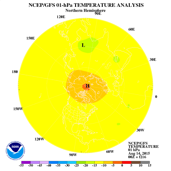
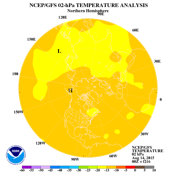
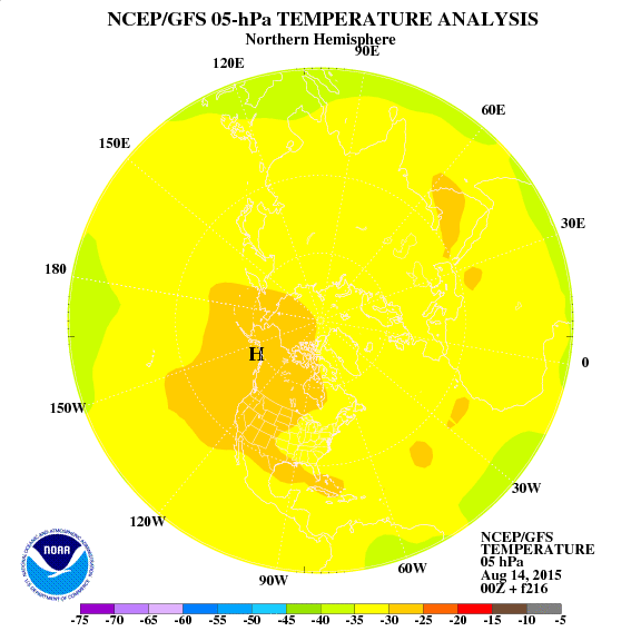
چشم انداز دمای تراز های استراتوسفر در 216 ساعت آینده
تراز 1 هکتوپاسکال
2 هکتوپاسکال
5 هکتو پاسکال
تراز 10 هکتوپاسکال:
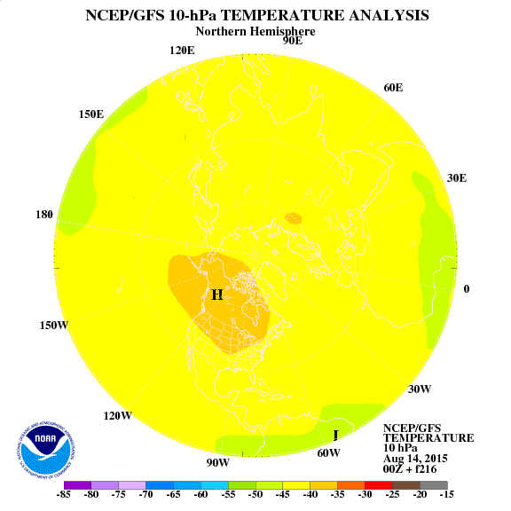
تراز 30 هکتو پاسکال:
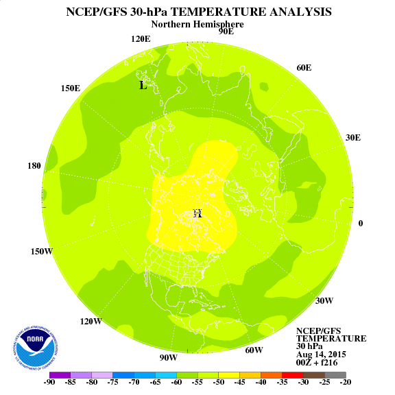
50 هکتو پاسکال:
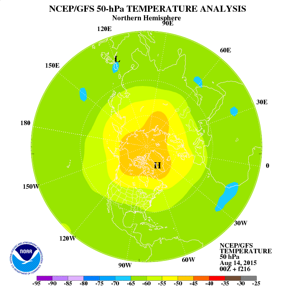
70 هکتو پاسکال:
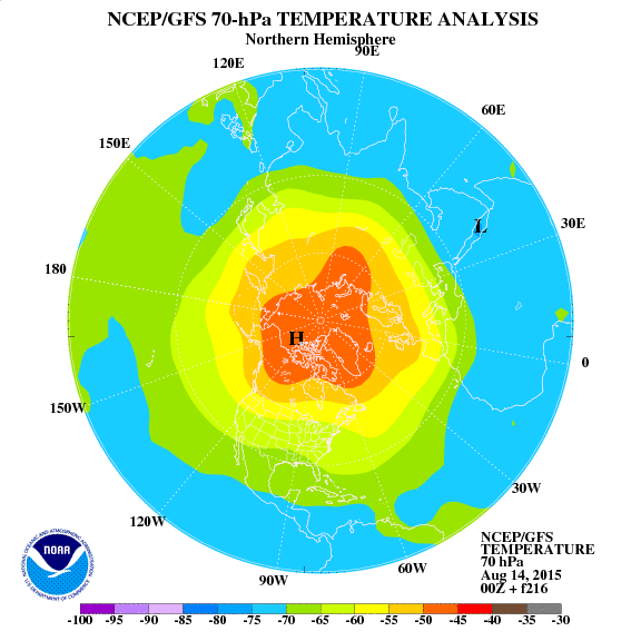
100 هکتو پاسکال:
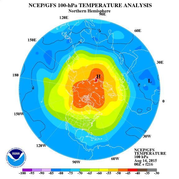
تراز 1 هکتوپاسکال

2 هکتوپاسکال

5 هکتو پاسکال

تراز 10 هکتوپاسکال:

تراز 30 هکتو پاسکال:

50 هکتو پاسکال:

70 هکتو پاسکال:

100 هکتو پاسکال:

Amir Mohsen
متخصص بخش هواشناسی
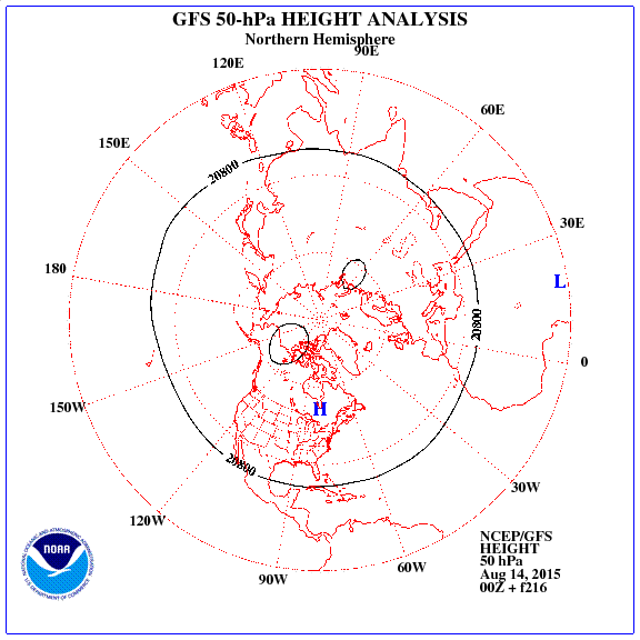
ارتفاع:




Amir Mohsen
متخصص بخش هواشناسی
اینهم وضعیت امروز تراز 10 هکتو پاسکال امروز برای نمونه که با 216 ساعت آینده مقایسه کنید:


Amir Mohsen
متخصص بخش هواشناسی
Amir Mohsen
متخصص بخش هواشناسی
- وضعیت
- موضوع بسته شده است.


