Wet, Wintry and Cold Week in Southern Europe
January 20, 2015; 7:58 AM
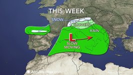
To begin the workweek, a deep trough of low pressure across western Europe kept the region unsettled with areas of rain and mountain snow. While Spain received the most widespread precipitation on Monday, rain and snow did fall in portions of France as well.
ي
As this disturbance moves east across the Mediterranean Sea this week, drier air will move into Portugal and western Spain bringing an end to the widespread rain and permitting a few breaks of sunshine as well. Both Tuesday and Thursday will feature numerous showers across the interior of Spain, but no widespread heavy rainfall is expected.
A strong onshore flow will, however, continue to produce daily rain and mountain snow across northern Spain. These areas could experience some flooding problems as rainfall will total 50-100 mm (2-4 inches) through Friday.
As the cold air remains across the region, snow will continue to fall across the higher terrain. The Cantabrain Mountains in northern Spain will likely see rounds of snow throughout the week above 1,000 meters (3,300 feet). Even the highest peaks, above 1,500 meters (5,000 feet), in southern Spain can see some snowfall.
Snow will also fall in southern France above 1,000 meters (3,300 feet) across the Massif Central. As the week progresses, snow will become more widespread in the Alps from France through Italy and Austria.
As this disturbance moves into the Mediterranean during the middle of the week, it will bring unsettled conditions to central Europe. From Wednesday into Friday, the heaviest rains will impact parts of Italy, the western Balkan Peninsula and even the northern coast of Algeria and Tunisia.
On Wednesday, downpours will invade southeastern France, while widespread rain and showers are expected over Italy and areas from Croatia to Montenegro.
The storm will continue to shift eastward slowly on Thursday and Friday causing downpours to become more widespread across Italy and the western Balkan Peninsula.
Also during this time, a strong north gradient will pile moisture into the northern coastline of Algeria and Tunisia causing daily downpours.
Rainfall on Thursday and Friday will total 25-50 mm (1-2 inches) across these regions with localized amounts in excess of 100 mm (4 inches). Flash flooding will be concern along with mudslides in areas of rugged terrain.
Meteorologist Adam Douty contributed to this story.


