• توجه: در صورتی که از کاربران قدیمی ایران انجمن هستید و امکان ورود به سایت را ندارید، میتوانید با آیدی altin_admin@ در تلگرام تماس حاصل نمایید.

تجزیه و تحلیل وضعیت جوی در سال زراعی 93-94 /فصل دوم( دي- بهمن-اسفند)

وضعیت
موضوع بسته شده است.

Amir Mohsen

متخصص بخش هواشناسی
نفوذ پر فشار از سمت سواحل شمالی و کاهش ارتفاع و فشار سطح دریا در نیمه جنوبی( الگوی فوریه)


CFSv2.z200.20150121.201502.gif


CFSv2.Prec.20150121.201502.gif


بدرود تا بعد...........
 

ali_kermanshah

کاربر ويژه
نفوذ پر فشار از سمت سواحل شمالی و کاهش ارتفاع و فشار سطح دریا در نیمه جنوبی( الگوی فوریه)


CFSv2.z200.20150121.201502.gif


CFSv2.Prec.20150121.201502.gif


بدرود تا بعد...........
افزایش ارتفاع در شمال دریای خرر برای سواحل که فکر کنم عالی باشه .
برای باقی مناطق هم فکر کنم خوب باشه .
 

ali_kermanshah

کاربر ويژه
Snow to Cause Travel Problems in United Kingdom


January 20, 2015; 11:53 AM ET

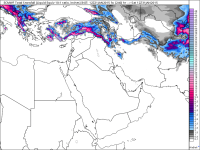
A weak wave of low pressure will drop southward across the United Kingdom Tuesday night into Wednesday
encountering a very chilly air mass which will result in frozen precipitation.
The areas most likely to see accumulating snow include western Scotland, Northern Ireland as well as the higher terrain of Wales and the Midlands
.
image.jpg

While accumulations will generally be on the order of 2-5 cm (1-2 inches) some of the highest terrain could see 10 cm (4
inches) or more.
Roadways will likely become snow covered leading to dangerous travel, especially Tuesday night and early Wednesday morning.Outside of these areas, a mixture of rain and snow will fall even farther south to the coast of England. London will also likely get snow mixed with rain, but any accumulation will be short-lived as temperatures remain above freezing through Wednesday afternoon.Chilly air will remain entrenched across the region through Thursday, before milder and more seasonable air returns from the Atlantic from Friday through the weekend.


ali_kermanshah

کاربر ويژه
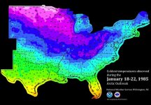
30th Anniversary: The Great Cold Outbreak of 1985

January 21, 2015; 12:19 PM ET

image.jpg
This morning, 30 years ago, I awoke to the coldest temperatures I had ever recorded in my paper weather logs. (I was 10 years old at the time.) It was -5 degrees F at my house in Boomer, North Carolina, at the foot of the Appalachian Mountains.The cold outbreak of Jan. 21, 1985, was here. Temperatures had fallen below zero across the Deep South and were in the single digits on the Carolina and Gulf coasts. This map shows the lowest temperatures (click through for a station-by-station list):
Nationally, the NWS in Wilmington says, "According to newspaper reports at least 165 fatalities were attributed to the weather. The inauguration parade for President Reagan's second term was canceled with wind chills in Washington DC colder than -10° F. Florida's Secretary of Agriculture termed this the "freeze of the century" with the state's citrus industry suffering $2.5 billion in losses."
 

پیوست ها

  • image.jpg
    image.jpg
    95.2 کیلوبایت · بازدیدها: 8
آخرین ویرایش:

ali_kermanshah

کاربر ويژه
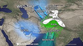
WATCH: Rain Floods Middle East; Heavy Snow Piles Up in Mountains

مشاهده پیوست 60875
The disturbance bringing this rain and snow will continue to track to the northeast pushing rain and snow into areas from
Kyrgyzstan and far western China to northwestern India through as least Thursday. The heaviest snow will shift east from Afghanistan into the western Himalayans.
This system could eventually bring improvements to the poor air quality that has been plaguing parts of northern India for several weeks.
 

پیوست ها

  • image.jpg
    image.jpg
    115.3 کیلوبایت · بازدیدها: 8
آخرین ویرایش:

seyyedalireza

مدیر موقت
WATCH: Rain Floods Middle East; Heavy Snow Piles Up in Mountains

مشاهده پیوست 60875
The disturbance bringing this rain and snow will continue to track to the northeast pushing rain and snow into areas from
Kyrgyzstan and far western China to northwestern India through as least Thursday. The heaviest snow will shift east from Afghanistan into the western Himalayans.
This system could eventually bring improvements to the poor air quality that has been plaguing parts of northern India for several weeks.

خدا کنه از آرن خبرها برا ماهم بزارم این سايتا
 

samann

کاربر ويژه
اپدیت امروز نوسان قطبی بسیار امیدوار کننده بود. به امید خدا اپدیتها از فردا باید بهبود پیدا کنه:گل:
 

DR WHO

کاربر ويژه
Return of the Polar Vortex?by James Hoover / January 20th, 2015
In the winter of 2014-15 has the polar vortex wind-chill jolt subsided? Do we even need to address its source and its cause? Scientists promise that it is part of the extremes climate change brings, and will return. But how is that paradox – extreme cold out of a warming planet — possible?
It’s elementary – at least initially.
The movement of air from high pressure to lower pressure is called wind. The wind’s strength depends on the pressure differences between warm air that rises and cold air that falls. The jet stream is a higher altitude air flow that affects hemispheric weather in the troposphere.
The Earth rotates counter-clockwise at 1040 miles per hour, completing the rotation in 23.93 hours, a rotation that acts on the jet stream. The Earth’s rotation sends the North to South air flow from West to East in the Northern Hemisphere. The jet stream forms due to pressure differences between warm air near the equator (which rises traveling North) and cold air near the arctic (traveling South). The cross-section of the N-S flow of subtropical and polar jet stream is shown in this Wikipedia article.
Jet streams are usually located anywhere from 25,000-48,000 feet above the surface of the Earth and their winds range anywhere from 57 miles per hour to 300 miles per hour. The greater the temperature/density differences between the arctic and the equator, the greater the force of the jet stream which forms in the tropopause (between the troposphere and the stratosphere). Higher Arctic temperatures lessen the difference and thus weaken the jet stream’s strength, causing it to drift and meander more often in the winter, guiding southward what scientists call the polar vortex.
The typical polar vortex in the Northern Hemisphere is on the left and the atypical is on the right. These cold-core low-pressure areas become stronger in the winter and weaken in the summer because the air current depends on the temperature difference between the equator and the poles.
Normally the polar vortex is a huge ring of circulating air extending in the Earth’s stratosphere, which starts some 10 miles from the Earth surface. Its temperature is about -100 degrees Fahrenheit, with its vortex constricted by a jet of some-100-mph wind. Last January waves of wind and pressure disrupted the vortex from below the stratosphere and split it apart, allowing bitter cold air to spill out from the Arctic into lower latitudes.
The polar vortex on the right in the image is larger in diameter and less defined and extends into the South, atypically covering southern areas in North America and Europe. The typical vortex configuration on the left is that of November, 2013. The wavy vortex on January 5, 2014 corresponded with 50 daily record low temperatures being set from Colorado to Alabama to New York, some 40 degrees Fahrenheit colder than average. The same errant Jet Stream parked near the United Kingdom and Ireland – and I do mean parked – bringing a train of storm systems over the British Isles.
According to Professor Jennifer Francis of Rutgers University, the weather patterns are already changing and could get worse: “The Arctic has been warming rapidly only for the past 15 years.” In the winter, this renders the Jet Stream less defined and carries polar air farther South, often characterized by stalls of weather fronts, dumping tons of snow in one locality, carrying with it bitterly cold temperatures. “We can expect more of the same, and we can expect it to happen more frequently,” she said.
Atmospheric researchers say that’s because of shrinking ice in the seas in Arctic regions. Less ice would let more energy go from the ocean into the air, and that would weaken the atmospheric forces that usually keep cold air trapped in the Arctic. A weaker Jet Stream lets Arctic air escape and wander south, more apt to slow down and drift, even stall, bringing with it weeks of Arctic super chill and blizzard conditions. Contrarily Alaska and parts of Scandinavia had exceptionally warm conditions last winter, while March of 2013 saw temperatures fall more than 18 degrees F in parts of Germany, Russia, and Eastern Europe.
But it’s not just shrinking ice according to Patrick Taylor, a scientist at NASA’s Langley Research Center in Hampton, VA. Overall, the Earth has warmed about 1.44 degrees Fahrenheit over the last 40 years. It doesn’t seem like much, and climate change deniers often point this out. Ignored is the fact that Arctic air has warmed 3.5 degrees Fahrenheit over the same period. This difference is relatively significant when the resulting West-to-East jet stream flow between the Arctic and the Equator in the winter diverts polar air masses.
Noting multiple complexities of weather condition, Taylor says, “The total warming at the poles is due to changes in clouds, water vapor, surface albedo, and atmospheric temperature. Greater warming in winter than in the summer is causing the energy transport over the Arctic” through large weather systems.
That happened relatively infrequently in the 1990s, but since 2000 it has happened nearly every year, according to a study published Tuesday in the journal Nature Communications. A team of scientists from South Korea and United States found that many such cold outbreaks happened a few months after unusually low sea ice levels in the Barents and Kara seas, off Russia.
In the new year, The Global Forecast System (GFS) and the European Center for Medium Range Weather Forecasts both call for -40 degree Fahrenheit lows from Minnesota to Maine during the Tuesday through Friday period, exactly a year to the day after the polar vortex of 2014. Chicago may even see a subzero high for the first time since January 6, 2014, with frigidity spreading to the East coast. But this one is scheduled to be short-lived, lasting only a few days to the weekend.
Luckily the Earth’s rotation hasn’t changed though the temperature of the arctic air has. Empirical evidence shows that higher arctic temperatures have altered the jet stream flow, along with what scientists call the polar vortex. Research and modeling continue but many scientists think that climate change (aka, global warming) is the key factor in weather extremes – paradoxically, not just confined to hot, dry, wet, violent, and stormy, but also to the bitterly cold.
After all, we are talking about measured extremes in a once millennially balanced world.
James Hoover is a recently retired systems engineer. He has advanced degrees in Economics and English. Prior to his aerospace career, he taught high school, and he has also taught college courses. He recently published a science fiction novel called Extraordinary Visitors and writes political columns on several websites. Read other articles by James.
 

abtinT

کاربر ويژه
شاخص ها رو در ماه فوریه بررسی کردم در زمان هایی که شاخص های ao , nao ,pna نزدیک خنثی هستن بارش تهران خوب بوده .
 

DR WHO

کاربر ويژه
ITV REPORT 21 January 2015 at 1:00pmJet Stream on the move - Less cold by the WeekendFrom last weekend the jet stream has been south of our shores - keeping low pressure systems at bay but allowing very cold air to linger over the UK for much of the week.For the rest of the working week we stick with cold days and frosty nights, with the risk of icy patches and maybe some freezing fog. Thursday should stay dry but rain will move in on Friday - beginning a process of change. This week the jet strems has been south of us - leaving the UK on it's colder sideThis week the jet strems has been south of us - leaving the UK on it's colder side Credit: Met Office/ ITVAs we head into the weekend the jet stream is on the move again - this time returning north of the UK.By Sunday it will have introduced a milder airstream with temperatures back to near-normal. But this will be a more mobile and more unsettled set up, with a higher risk of stronger winds and spells of rain - especially the further north and west you are. By the second half of the weekend the jet returns north of the UK, bringing milder air our wayBy the second half of the weekend the jet returns north of the UK, bringing milder air our way Credit: Met Office/ ITVLast updated Wed 21 Jan 2015
 
وضعیت
موضوع بسته شده است.
بالا