• توجه: در صورتی که از کاربران قدیمی ایران انجمن هستید و امکان ورود به سایت را ندارید، میتوانید با آیدی altin_admin@ در تلگرام تماس حاصل نمایید.

مباحث عمومی هواشناسی- خرداد ماه 1393

وضعیت
موضوع بسته شده است.

Amir Mohsen

متخصص بخش هواشناسی
فردا به امید خدا فیلم بارش امروز رو حجمش رو کم میکنم و حتما هم در اختیار دوستان خوبم قرار میدم و هم یک نسخه رو هم به هواشناسی استان .
 

Amir Mohsen

متخصص بخش هواشناسی
شب دوستان عزیز خوش و آرام


meteogram_celcius.cgi
 

DR WHO

کاربر ويژه
May 19, 2014 (notes updated May 26, 2014)
ENSO forecast: El Niño will develop and reach its height in late boreal summer and then remain at least through winter.
Indian Ocean forecast: A weak negative IOD is predicted as an ensemble average for the tropical Indian Ocean from summer to fall in 2014. However, we need to be careful about this prediction because the prediction plume is spread rather widely.
Regional forecast: Most part of Europe, Africa, Middle East, Russia, India, Southeastern Asia and western U.S. will experience a warmer-than-normal summer owing to the development of El Niño. In contrast, eastern China, central-eastern U.S. and Japan will experience a cooler summer. In the Southern Hemisphere, most part of Australia will be colder-than-normal in austral winter, while most part of Africa and South American Continent will be warmer-than-normal.
In the boreal fall, most part of Europe, Africa, Middle East, India, Southeast Asia, most parts of China, Korea, northern Japan, and Mexico will be in a warmer-than-normal condition, whereas eastern Russia, most part of U.S., southern Canada, and southern Japan will be in a colder-than-normal condition. In case of the negative IOD in the Indian Ocean, the unique combination with El Nino in the Pacific is similar to the situation in 1993, a year of record-breaking cool summer in the northeastern part of Japan.
The Maritime Continent in Asia, India, and Caribbean countries will be in a drier-than-normal condition in the boreal summer and fall owing to the El Niño. On the other hand, wetter-than-normal condition is predicted for U.S., Peru, Colombia, Ecuador, and western Brazil. Above normal precipitation is also expected in Japan in summer because of the active and somewhat prolonged Baiu-season. In the austral spring, Angola, Namibia, and central Australia will be in a drier-than-normal condition.
 

samann

کاربر ويژه
امیدوارم با توجه به آفتاب امروز شاهد همرفت قوی باشیم.
هوا هم کاملا مشخصه که شرجیه:گل: به هرحال دیگه باید پرونده بارش امسالو بست .
ما هرچه دعا کردیم که به 200 برسیم نشد که نشد
 

Amir Mohsen

متخصص بخش هواشناسی
[h=4]Forecast
The report was made 1 hour and 51minutes ago, at 06:12 UTC
Forecast valid from 30 at 06 UTC to 31 at 12 UTC
Wind 25 km/h from east/southeast
Visibility 10 km or more
Few clouds at a height of 1067 m
Scattered clouds at a height of3048 m
Temporary
from 30 at 09 UTC to 30 at 18 UTC
Wind 29 km/h from east/northeast
Visibility 3000 m
Scattered clouds at a height of 914m , Cumulonimbus.
Scattered clouds at a height of1067 m
Broken clouds at a height of 2743m
thunderstorm rain
Becoming
from 30 at 22 UTC to 30 at 24 UTC
Visibility 3000 m
Scattered clouds at a height of 610m
mist
Becoming
from 31 at 03 UTC to 31 at 05 UTC
Visibility 7000 m
Few clouds at a height of 1067 m
Scattered clouds at a height of3048 m
Temporary
from 31 at 06 UTC to 31 at 12 UTC
Wind 25 km/h from east/northeast
Visibility 3000 m
Scattered clouds at a height of 914m , Cumulonimbus.
Scattered clouds at a height of1067 m
Broken clouds at a height of 2743m
thunderstorm rain
 

شهاب از بوشهر

کاربر ويژه
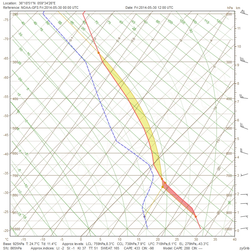
نمودار اسکیوتی ساعت 12 یو تی سی امروز مشهد منتشر شده و با اجازه اساتید بنده نمودار را شرح می کنم.

اول از همه طبق ان چه که نمودار اعلام کرده ، میزان شاخص کیپ (انرژی پتانسیل همرفتی در دسترس) برای عصر امروز در مشهد عدد 433 می باشد که نشان دهنده وقوع ناپایداری در حد متوسط هست.

دوم شاخص ناپایداری شوالتر هست که عدد -1 (منفی یک ) را نشان می دهد و بیانگر وقوع ناپایداری در حد متوسط هست.

سوم شاخص ناپایداری sweat می باشد که عدد 165 را نشان داده و موید وقوع طوفان و ناپایداری در حد متوسط می باشد.

و در پایان شاخص ناپایداری TTI می باشد که عدد 51 را نشان می دهد و مبین وقوع طوفان شدید هست.

با این تفاسیری که صورت گرفت ، می توان نتیجه گرفت که امروز عصر و امشب شرایط برای رخداد بارش و ناپایداری در شهر مشهد فراهم گردیده است.

skwti%20mashhad1.jpg


Amir Mohsen

متخصص بخش هواشناسی
آپدیت جدید جی اف اس

و این یعنی آغاز همرفت از بینالود و همگرایی با هزار مسجد

غرب مشهد بنظر بیشترین بهره را خواهد برد . مثل دیروز که حدود 7 تا 10 میلیمتر باریده بود


Sent from my SM-N900 using Tapatalk
 

seyyedalireza

مدیر موقت
به نظر من از نظرتجربی مشهد تا الان 200 تااومده ولی فقط ثبت نشده
به نظرم امورزم بارش خوبی درمشهد داریم
 
وضعیت
موضوع بسته شده است.
بالا