• توجه: در صورتی که از کاربران قدیمی ایران انجمن هستید و امکان ورود به سایت را ندارید، میتوانید با آیدی altin_admin@ در تلگرام تماس حاصل نمایید.

مباحث عمومی هواشناسی

وضعیت
موضوع بسته شده است.

شهاب از بوشهر

کاربر ويژه
سلام بر همگی.
بچه ها چرا ساکت هستید و چرا دیگه کسی پستی ارسال نمی کنه؟؟؟
بابا دنیا که به آخر نرسیده.
هنوز افراد زیادی تو این انجمن باقی موندن و ما باز هم می تونیم با هم فعالیت و درباره پدیده ها بحث و تبادل نظر کنیم.
 

mahmood600

کاربر ويژه
EUMETSAT_MSG_RGB-dust-easternEurope.jpg
 

Amir Mohsen

متخصص بخش هواشناسی
درود دوستان

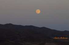
امشب وقتی بر میگشتم مشهد بالای گردنه گوجکی هوا خیلی خنک بود واسه همین توقف کردم و یک چای خوردم و این عکس رو گرفتم:

ماه1.jpg

ماه 2.jpg

البته عکس دوم رو از فاصله 25 کیلومتری شمال مشهد گرفتم که تا اینجا هوای خنک تداوم داشت ولی وقتی وارد مشهد شدم از شدت گرما مجبور شدم کولر روشن کنم!!!!!!!!!!!
 

Amir Mohsen

متخصص بخش هواشناسی
[h=2]Cooler, Less-Humid Break Coming Cincinnati to NYC, DC
sosnowski.png
[h=6]By Alex Sosnowski, Expert Senior Meteorologist [h=5]July 22, 2013; 1:35 PM
Share |

vbmyerse.jpg

A break from the high humidity with cooler conditions is on the way from the Ohio Valley to the mid-Atlantic starting at midweek.
While portions of the Great Lakes and New England got a break from the heat with high humidity over the weekend, the edge was merely taken off the heat wave farther south.
A new push of cooler and less-humid air will be more successful beginning later Tuesday and Tuesday night over the Ohio Valley, then spread to the mid-Atlantic Wednesday.
650x366_07221657_hd22.jpg

When comparing AccuWeather.com RealFeel® temperatures from last week to later this week, it will feel 25 degrees cooler in some cases.
City, StatePeak RealFeel® Last WeekHighest RealFeel WednesdayNormal High
New York1148083
Philadelphia1078085
Pittsburgh1067583
Cleveland1097384
Indianapolis1057482
Charleston, W.Va.1107983
Nashville, Tenn.1078189
Washington, D.C.1128286
Richmond, Va.1138487
The most notable change will be cooler nights and better sleeping weather for those who do not have air conditioning from mid- to late-week.
Temperatures will drop into the 50s over much of the Ohio Valley and central Appalachians as well as some of the northern and western suburbs of the I-95 cities. Lows will be in the 60s in the major metro areas along I-95 and the Tennessee Valley.
RELATED:
Northeast Regional Radar
Forecast Temperature Maps
Downpours in the East Monday night, Tuesday

However, construction projects that have been delayed because of intense heat last week may have some delays due to rain this week.
The change to cooler weather will be accompanied by drenching downpours in some areas Monday night into Tuesday.
A second pulse of rain may swing northward Thursday into Friday over the mid-Atlantic.
Much of the week may be unsettled from the Tennessee Valley to the southern Appalachians and parts of Virginia.


Amir Mohsen

متخصص بخش هواشناسی
A map showing maximum temperatures across the U.S. for July 10-19, 2013. Gray represents temperatures of 70°F while dark red represents temperatures above 107°F.
Credit: NOAA Environmental Visualization Laboratory​
 

Amir Mohsen

متخصص بخش هواشناسی
وضعیت دمای هوای امروز مشهد تا به همین لحظه:

meteogram_celcius.cgi


پس امروز هم مشهد اونقدر گرم نشده بوده چون من از ارتفاع پایین میومدم گرما احساس کردم!!!!
 

Amir Mohsen

متخصص بخش هواشناسی
خدا رو شکر بارشهای 30 جولای به بعد سواحل دریای کاسپین خصوصا نواحی غربیش هم سر جاشه:گل:

mean_sea_level_pressure_and_24h_cumulated_precipitations%21204%21Africa%21msl%21pop%21od%21oper%21w_mslrain%212013072212%21%21chart.gif
 

سایه

کاربر ويژه
سلام و عرض ادب خدمت دوستان فعال در بخش هواشناسی:گل:

ممنون میشم اگه وضعیت هوای استان گیلان رو در چند روز آینده بفرمایید:احترام:

البته اگه توضیح مختصری در مورد این اطلاعات هم بفرمایید ممنون میشم:خجالت2:کلا هیچ گونه اطلاعاتی در زمینه هواشناسی ندارم:خجالت:


Amir Mohsen

متخصص بخش هواشناسی
درود سایه خانوم عزیز

والا چشم انداز بارش در استان گیلان در حال بهبود هست در روزهای پیشرو بارشهایی رو خواهید داشت ولی از 27 جولای تا اول آگوست بارشهای نسبتا شدید تابستانه شما آغاز خواهد شد.:گل:

سلام و عرض ادب خدمت دوستان فعال در بخش هواشناسی:گل:

ممنون میشم اگه وضعیت هوای استان گیلان رو در چند روز آینده بفرمایید:احترام:

البته اگه توضیح مختصری در مورد این اطلاعات هم بفرمایید ممنون میشم:خجالت2:کلا هیچ گونه اطلاعاتی در زمینه هواشناسی ندارم:خجالت:
 

Amir Mohsen

متخصص بخش هواشناسی
Today, 09:17 AM


I need a new hobby other than weather
laugh.gif


I decided to stay up until about midnight doing some work with winter AO, NAO and PNA when compared to their preceding summer anomalies.

For the Arctic Oscillation, 46% of the years I looked at had a positive correlation, meaning both the summer anomalies and winter anomalies were negative or positive. 54% of the years I looked at had a negative correlation from summer to winter, meaning if the summer anomalies were positive, the winter AO anomalies were negative. The difference is so slight (46% to 54%) that this isn't really something to take interest in.

For the North Atlantic Oscillation, 45% of years analyzed had a positive summer-winter correlation, with 55% of years experiencing a negative correlation. Again, nothing to get excited about because the difference between the two is pretty small.

The PNA was the most significant in terms of siding with either the positive or negative correlation. 59% of years I examined had a positive correlation between summer and winter anomalies. Only 41% of years came in with a negative correlation. If you really wanted to, I would round it to 60%-40%, because I counted out a few years that would fit into the positive correlation category but decided they were too close to 0.00 to count.


Amir Mohsen

متخصص بخش هواشناسی
Today, 09:17 AM

I need a new hobby other than weather
laugh.gif


I decided to stay up until about midnight doing some work with winter AO, NAO and PNA when compared to their preceding summer anomalies.

For the Arctic Oscillation, 46% of the years I looked at had a positive correlation, meaning both the summer anomalies and winter anomalies were negative or positive. 54% of the years I looked at had a negative correlation from summer to winter, meaning if the summer anomalies were positive, the winter AO anomalies were negative. The difference is so slight (46% to 54%) that this isn't really something to take interest in.

For the North Atlantic Oscillation, 45% of years analyzed had a positive summer-winter correlation, with 55% of years experiencing a negative correlation. Again, nothing to get excited about because the difference between the two is pretty small.

The PNA was the most significant in terms of siding with either the positive or negative correlation. 59% of years I examined had a positive correlation between summer and winter anomalies. Only 41% of years came in with a negative correlation. If you really wanted to, I would round it to 60%-40%, because I counted out a few years that would fit into the positive correlation category but decided they were too close to 0.00 to count.


در مطالب بالا این دوست مون ضمن اینکه ایشون هم از وضعیت شاخص ها چندان رضایت نداره مثل ما و گفته باید این عادت و علاقه هواشناسیش رو سرانجام کنار بذاره تقریبا اومده یک مقایسه آماری انجام داده بین رابطه آنومالی شاخص های NAO , AO در فصل تابستان و زمستان !!

خلاصه کلام ایشون به این نتیجه رسیده که اگه در فصل تابستون هر کدم از این شاخصها روند مثبت شدن رو طی کنند بر اساس آمار باید در فصل زمستون این شاخص ها وارد فاز منفی خودشون بشند و البته معکوسش هم مصداق داره!!!!

ناگفته هم نمونه که هیچ چیز در هواشناسی معنا و مفهوم مطلق نداره که ایشون هم به صراحت اعلام کرده این موضوع رو

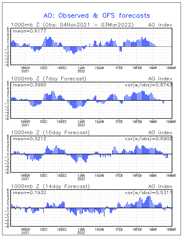
روند گذشته و کنونی و آینده شاخص AO:

ao.mrf.gif


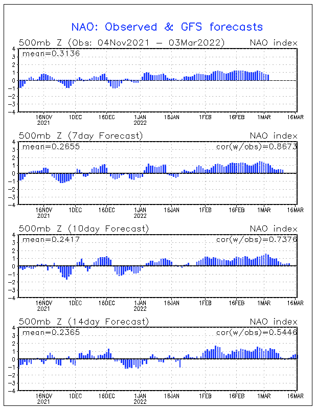
اینهم به همون ترتیب شاخص NAO :

nao.mrf.gif
 
وضعیت
موضوع بسته شده است.
بالا